Suzhou Creek Riverside Walk: Art, History, and Water in the Heart of Shanghai
The Suzhou Creek Riverside Walk is a free, continuous waterfront promenade stretching through central Shanghai, connecting industrial heritage, contemporary art spaces, and centuries-old bridges. Open 24 hours, it rewards early risers, photographers, and anyone curious about the city beyond its famous skyline.
Quick Facts
- Location
- Along Suzhou Creek (苏州河), central Shanghai — from Linkong Musical Park near the west outer ring road in the west to Waibaidu Bridge at the Bund in the east
- Getting There
- Natural History Museum Station (Line 13, Exit 3); Qufu Road Station (Lines 8 & 12); East Nanjing Road Station (Lines 2 & 10)
- Time Needed
- 1.5–4 hours depending on segment; a curated art-focused route covers about 4.7 km
- Cost
- Free (riverside walk); adjacent venues charge separately — e.g., Shanghai Natural History Museum ~¥30, Fotografiska ~¥80–90
- Best for
- Walkers, photographers, architecture lovers, and independent explorers
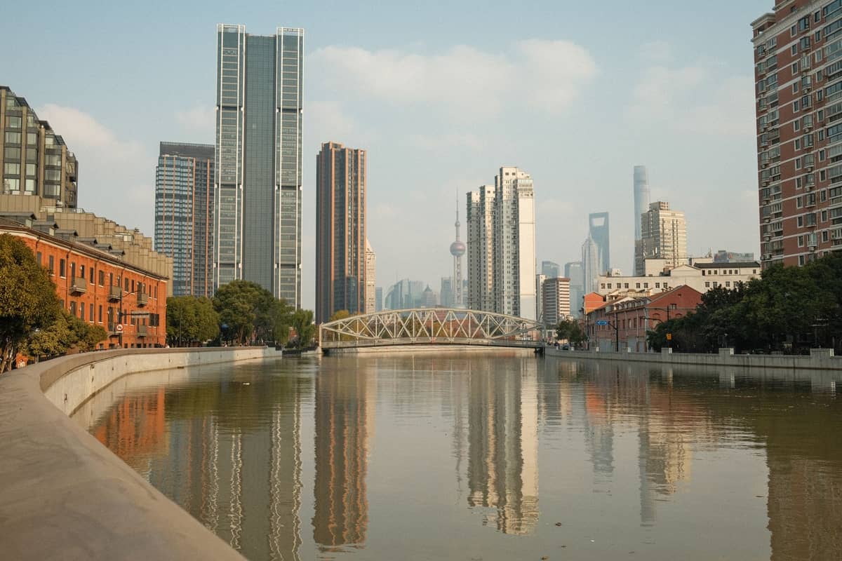
What the Suzhou Creek Riverside Walk Actually Is
The Suzhou Creek Riverside Walk — officially the 苏州河滨水步道 — is a publicly accessible waterfront promenade running along both banks of Suzhou Creek through central Shanghai. The creek itself stretches roughly 53–54 km through the city, and by December 2020 approximately 42 km of its central-city riverfront had been unified into a single, continuous pedestrian path, from Linkong Musical Park near the outer ring road in the west all the way to Waibaidu Bridge, where the creek meets the Huangpu River at the Bund.
This is not a manicured tourist corridor. It is a layered urban walk through neighborhoods that are still actively in transition: former industrial warehouses converted into galleries, century-old iron bridges carrying cyclists and grandmothers with groceries, and stretches of quiet waterfront that feel a world away from the retail intensity of Nanjing Road ten minutes' walk to the south. The walk is free, open 24 hours a day, every day of the year, and accessible at multiple points via the metro.
💡 Local tip
Do not try to walk the entire 42 km in one go. Most visitors choose a 3–5 km segment. The most rewarding curated route runs from the Shanghai Natural History Museum area east through the Suhe district, past the Guangxin Road Bridges cluster, and down to Waibaidu Bridge — about 4.7 km with art stops included.
The History Behind the Water
Suzhou Creek was once the economic artery of Shanghai's industrial age. From the late 19th century through the mid-20th century, its banks were lined with warehouses, flour mills, cotton mills, soap factories, and godown storage yards. Goods moved along it by wooden barge; smoke from factory chimneys sat low over the water. The creek was also notoriously polluted — by the 1970s it was essentially an open industrial drain, and restoring it to ecological health took decades of infrastructure investment that continued into the 2000s.
The industrial buildings that survived are now the walk's most distinctive feature. Many have been repurposed rather than demolished, which is relatively unusual in a city that has moved fast to replace its built fabric. The result is that walking the creek gives you a texture of Shanghai that neither the Bund nor Lujiazui can offer: architecture that carries memory, in neighborhoods where the city's working-class and creative economies now share the same block.
One of the most significant concentrations of converted industrial space sits at Moganshan Road, home to M50 Creative Park, a cluster of galleries and studios occupying former textile mill buildings from the 1930s to 1950s. Reaching it from the riverside takes about five minutes on foot from the Jiangning Road Station on Line 13.
Tickets & tours
Hand-picked options from our booking partner. Prices are indicative; availability and final rates are confirmed when you complete your booking.
Shanghai city and Zhujiajiao water town private tour with lunch
From 371 €Instant confirmationFree cancellationShanghai private tour with iconic landmarks of the old and new city
From 284 €Instant confirmationFree cancellationShangai Yuyuan Garden entrance tickets
From 9 €Instant confirmationFree cancellation
How the Walk Changes Through the Day
Early morning on the creek is its quietest, most local hour. Between 6am and 8am you share the path with retirees doing slow walks, older residents fishing with bamboo rods from the bank, and the occasional cyclist moving fast in the opposite direction. The water reflects whatever light is available and, in cooler months, carries a faint chill off the surface. There is very little English spoken at this hour; this is the creek as neighborhood utility, not attraction.
By mid-morning, the character shifts. Visitors with cameras appear, the galleries near M50 begin opening their doors, and cafe terraces along the Suhe Riverside section fill with people ordering coffee in a mix of Mandarin and English. Weekday mornings between 9am and 11am offer the best balance of light and low crowds for photography — the water catches the sun from the southeast, and the converted warehouses photograph well without harsh overhead shadows.
Weekend afternoons bring the most people to the Suhe district and the bridges section near Waibaidu. The promenade is wide enough that it never feels uncomfortably crowded, but solitude becomes harder to find. Sunset is popular at Waibaidu Bridge, where the creek meets the Huangpu and the Bund skyline opens up across the water. At night, the path stays lit and remains in use — particularly the eastern stretches near the Bund — though the industrial western segments become quieter and less patrolled after dark.
💡 Local tip
For the best light and photographs, walk east to west in the morning (sun behind you as you head toward M50) and west to east in the late afternoon (catching warm light on the bridges and Waibaidu). The direction matters more than most guides acknowledge.
Key Segments and What to Look For
The Bridges Walk (Qufu Road to Waibaidu Bridge, approx. 2 km)
This is the most architecturally concentrated section of the walk, passing around seven historic bridges in roughly 2 km. The bridges span multiple eras of Shanghai's engineering history, from iron truss structures built under foreign concession administration to mid-century concrete spans. Some carry pedestrians and cyclists; others carry traffic overhead while the walkway passes below through a riverbank underpass. Qufu Road Station on Lines 8 and 12 is the most practical entry point.
The final bridge in the eastward sequence is Waibaidu Bridge itself, Shanghai's oldest surviving iron bridge, completed in 1908. It marks the confluence of Suzhou Creek and the Huangpu River, and from it you have a direct sightline south along the Bund. It is a genuine piece of engineering history, not a reconstruction — the original riveted steel structure is still the structure you walk across.
The Suhe Riverside and Guangxin Road Section
This central segment, accessible from Shanghai Natural History Museum Station on Line 13, is where the walk becomes most deliberately curated. The Suhe Creative Riverside zone contains cafes, design shops, and gallery spaces inside converted warehouse buildings set directly on the water. It is the most photographed stretch of the creek and the most visitor-oriented, which has both advantages and drawbacks: the infrastructure is well-maintained, signage exists in English, but it can feel polished in a way that the rawer western sections do not.
The Shanghai Natural History Museum is immediately adjacent to this section, set within Jing'an Sculpture Park. Its ticket price is approximately ¥30 and requires advance booking via the official app. The Jing'an Sculpture Park surrounding it is free to enter and provides a good staging point before beginning the walk east.
M50 Creative Park and the Moganshan Road Section
West of the Suhe district, the path passes below Moganshan Road, where M50 Creative Park sits back from the creek behind a set of factory-era buildings. This is one of Shanghai's oldest-established contemporary art clusters and still one of the most serious: the galleries here tend toward international contemporary fine art rather than the decorative craft that dominates some of the city's newer creative markets. Entry to the park itself is free, though individual galleries charge for ticketed shows.
For a fuller picture of Shanghai's contemporary art landscape, the Shanghai contemporary art guide covers M50 alongside the West Bund galleries and Power Station of Art, which can be combined with a Suzhou Creek visit on an art-focused day.
Practical Details: How to Get There and How to Walk It
The walk has no single entrance. Most visitors choose a starting metro station based on the segment they want to cover. For the eastern bridges and Bund end, East Nanjing Road Station on Lines 2 and 10 is the most convenient, placing you within a roughly five-minute walk of Waibaidu Bridge. For the Suhe creative district and the art-focused central section, Shanghai Natural History Museum Station on Line 13, Exit 3, drops you directly at the park's edge. For the Moganshan Road and M50 section, Jiangning Road Station on Line 13 is the closest stop.
The path is largely flat across all sections, making it accessible for most walkers. The bridges section involves some stairs and ramps to cross from bank to bank or pass under bridge abutments, and specific accessibility features such as elevator access are not consistently documented — visitors with significant mobility limitations should check current conditions for specific entry points before visiting.
Comfortable shoes are the only equipment requirement. The surface varies from smooth paving in the Suhe zone to rougher concrete and gravel in older sections. In summer, sun exposure on the path is significant and shade is intermittent; bring water. In the plum rain season from June to early July and during typhoon-adjacent rain events from July to September, the path stays open but sections near the waterline can be slippery. Autumn, from October to mid-November, brings the best conditions: low humidity, moderate temperatures, and the most photogenic light.
⚠️ What to skip
Adjacent indoor venues — galleries, Fotografiska Shanghai, and the Shanghai Natural History Museum — have their own separate opening hours and ticketing. Fotografiska charges approximately ¥80–90 per person (weekday/weekend pricing varies). Always verify ticket availability in advance, especially on weekends. These venues are not part of the free riverside walk itself.
Photography Along Suzhou Creek
The creek rewards patient photography more than hurried snapshots. The strongest subjects are structural: the riveted ironwork of Waibaidu Bridge against a clear sky, the reflection of repurposed factory facades in still water at dawn, and the graphic repetition of similar bridge spans viewed in sequence from the bank. The early-morning light on the south-facing bank is particularly useful in autumn and spring when the sun angle is low enough to illuminate the waterline without washing out the stone and metal textures.
The walk connects naturally with broader photography itineraries around the city. For a dedicated approach to image-making in Shanghai, the best photo spots in Shanghai guide covers both the Bund side of Waibaidu Bridge and the M50 district, which can be threaded into a single morning session beginning at the creek.
Honest Assessment: What to Expect and Who Might Not Connect with It
The Suzhou Creek Riverside Walk is not an attraction with a clear payoff moment. There is no single landmark that justifies the visit on its own. What it offers instead is cumulative: a sense of how Shanghai thinks about its industrial past, and how urban regeneration can preserve texture rather than erase it. Travelers who need a checkbox experience will likely feel the walk undersells itself. Travelers who are comfortable wandering without a destination will find it one of the more satisfying hours they spend in the city.
Some sections, particularly in the western stretches toward Beixinjing, remain genuinely rough-edged and are not maintained to the standard of the Suhe zone. If you base your expectations entirely on the well-photographed Suhe district images that circulate online, the less-curated sections can feel anticlimactic. Go in knowing the full walk is a spectrum, not a uniform promenade.
If you are building a self-guided walking day, the Suzhou Creek section pairs particularly well with nearby areas. The best self-guided walks in Shanghai guide includes suggested routes that connect the creek with Jing'an and the North Bund area, avoiding backtracking.
Insider Tips
- Walk the bridges section on a weekday morning and look for fishermen under the northern bank — they set up early and are gone by mid-morning, and the scene is one of the most authentically local on the entire walk.
- The rooftop terrace at Fotografiska Shanghai, when open with a ticketed visit, gives you one of the better elevated views along the creek that most visitors never see from the promenade below.
- The stretch of path immediately west of M50 near Changhua Road tends to see far fewer visitors than the Suhe zone despite being equally interesting architecturally. Walk it first, then circle back to the galleries.
- Download an offline map before you start — the riverside path occasionally diverges from the street grid and Google Maps can lose the trail near some of the bridge underpasses. Amap (AutoNavi) handles the creek path more reliably.
- If you visit during autumn, the plane trees (French planes, planted during the concession era) that line stretches of the embankment drop yellow leaves onto the path in October — a detail that barely registers in summer but transforms the same walk aesthetically.
Who Is Suzhou Creek Riverside Walk For?
- Architecture and urban history enthusiasts who want to read Shanghai's industrial past in its surviving buildings
- Photographers looking for early-morning water reflections, iron bridge structures, and converted warehouse textures
- Independent walkers who prefer to navigate a city at ground level without a fixed itinerary
- Contemporary art visitors combining M50 Creative Park or Fotografiska with an outdoor walk between venues
- Repeat visitors to Shanghai who have already covered the main tourist landmarks and want a different register of the city
Nearby Attractions
Combine your visit with:
- Chongming Island
Chongming Island sits at the mouth of the Yangtze River, a vast alluvial island that functions as Shanghai's rural counterweight. Wetland reserves, a national forest park, cycling paths through farmland, and virtually no high-rises make it a genuinely different Shanghai experience.
- ERA Acrobatics Show
Running nightly at Shanghai Circus World in Jing'an District, ERA2 – Spirit of Shanghai is the city's flagship acrobatics production. Expect gravity-defying stunts, dramatic lighting, and a 60-to-100-minute show that needs no translation. Here is everything you need to know before buying a ticket.
- Jade Buddha Temple
The Jade Buddha Temple (玉佛禅寺, Yùfó Chán Sì) is one of Shanghai's most significant active Buddhist monasteries, housing two exceptional jade Buddha statues brought from Burma in the late 19th century. Unlike many temples that have become purely ceremonial attractions, this one functions as a working monastery, with monks in residence and daily rituals that visitors can witness firsthand.
- Jinshan City Beach
Jinshan City Beach (金山城市沙滩景区) is a man-made coastal resort on Hangzhou Bay, about 60 km south of central Shanghai. It is the closest thing to a genuine beach day the city offers, with designated swimming zones, a long promenade, and seasonal facilities. This guide covers what to realistically expect, when to go, and how to get there.