Southern Ridges: Singapore's Best Urban Nature Walk
The Southern Ridges is a 10 km trail network connecting five parks across Singapore's southwestern hills, from Kent Ridge to Mount Faber. Free, open 24 hours, and offering some of the city's finest elevated views, it rewards anyone willing to lace up and walk.
Quick Facts
- Location
- Southwest Singapore, linking Kent Ridge Park to Mount Faber Park
- Getting There
- HarbourFront (NE1/CC29), Labrador Park (CC27), Kent Ridge (CC24), or Pasir Panjang (CC26)
- Time Needed
- 2.5 to 4 hours for the full trail; 1 to 1.5 hours for highlights only
- Cost
- Free entry
- Best for
- Hikers, nature lovers, photographers, families with older children
- Official website
- www.nparks.gov.sg/activities/southern-ridges
What Is the Southern Ridges?
The Southern Ridges is a continuous 10 km trail network running along the forested hills of southwest Singapore. Conceived by the Urban Redevelopment Authority in 2002 and completed in stages, fully opened in 2008 at a cost of S$25.5 million, it stitches together five distinct parks: Kent Ridge Park, HortPark, Telok Blangah Hill Park, Mount Faber Park, and Labrador Nature Reserve. The result is one of the longest and most varied urban green corridors in Southeast Asia, all completely free to walk.
Unlike the manicured gardens of the Singapore Botanic Gardens or the curated spectacle of Gardens by the Bay, the Southern Ridges feels genuinely wild in stretches. Secondary rainforest presses in close on either side of the path. You will hear cicadas long before you see the skyline. At Telok Blangah Hill Park, the terrain rises to 94 metres, giving unobstructed views across the port and out to the islands of the Strait of Singapore. It is the kind of experience that makes visitors reconsider how dense this city actually is.
💡 Local tip
The trail is fully signposted and waymarked, but download the NParks map before you start. Mobile signal is patchy in the lower forested sections between HortPark and Kent Ridge.
The Trail in Order: What to Expect at Each Section
Most walkers start at Kent Ridge Park (accessible from Kent Ridge MRT, then a short taxi or bus ride, or a 15-minute walk uphill) and finish at Mount Faber or HarbourFront, making it a point-to-point route rather than a loop. This east-to-west direction means you end near MRT access and the cable car terminal, which suits first-timers.
Kent Ridge Park
Kent Ridge Park covers 47 hectares and carries significant wartime history. It was the site of the Battle of Pasir Panjang in February 1942, one of the last stands of the Malay Regiment against Japanese forces before the fall of Singapore. Reflections at Bukit Chandu, a memorial museum within the park, marks that history. The ridge here is wide and shaded, and in the early morning, kingfishers and sunbirds are regularly spotted in the canopy.
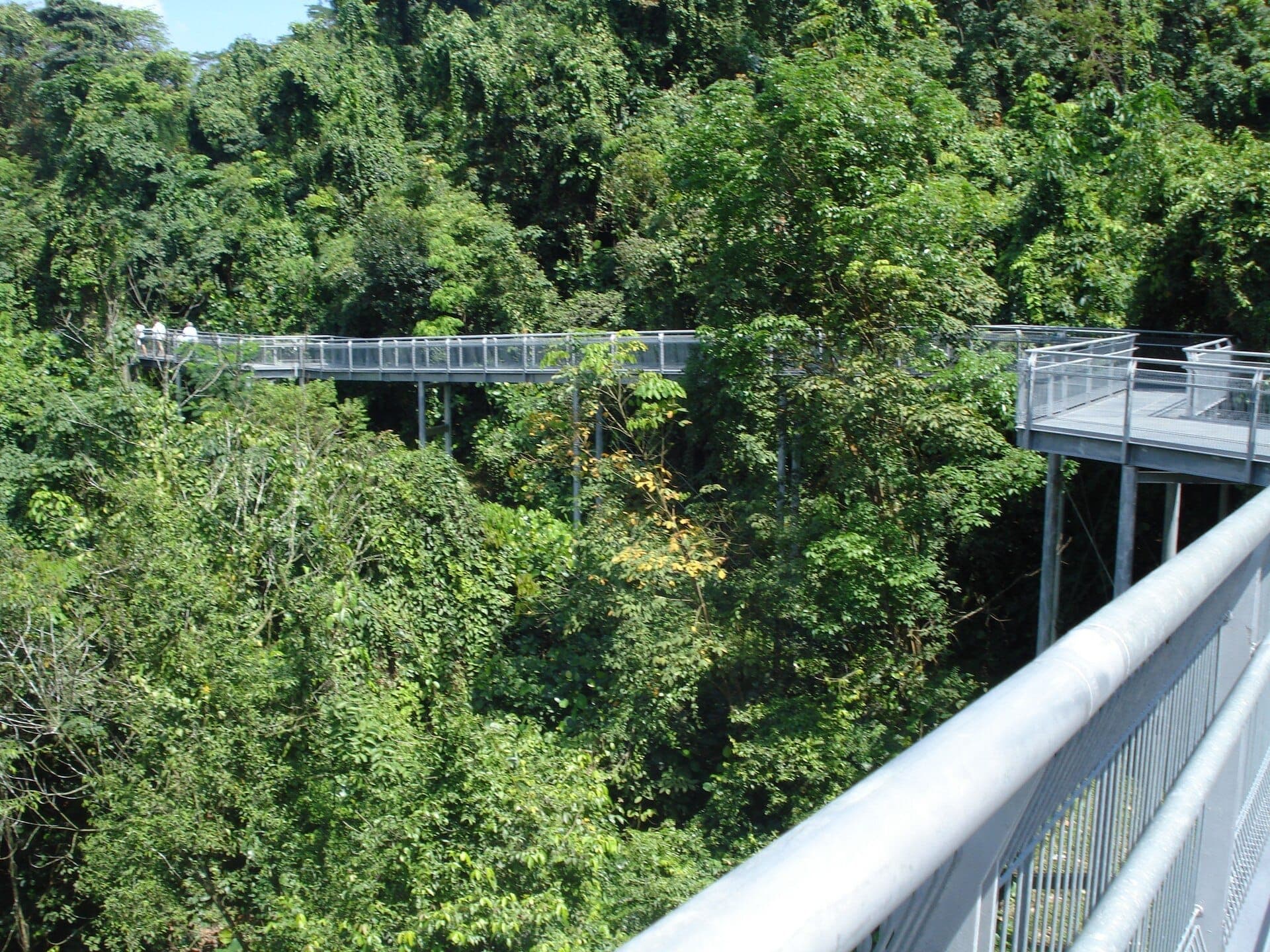
Canopy Walk and HortPark
The Canopy Walk is the trail's most photographed feature: a 280-metre elevated walkway suspended between trees, roughly level with the upper forest canopy. The structure sways slightly underfoot, which unnerves some visitors and delights others. From its highest point, you look out across a sea of palm crowns with the port cranes of Tanjong Pagar visible in the distance. It is best in the hour after sunrise when mist sometimes lingers in the lower valleys.
HortPark sits below the Canopy Walk and functions as a gardening hub and lifestyle park. It is a natural rest stop, with toilet facilities, water points, and a small café. Families with young children often come no further than HortPark, making it a solid half-day option on its own.
Telok Blangah Hill Park and the Henderson Waves
At 94 metres, Telok Blangah Hill Park is the highest point along the route and the location of the Henderson Waves bridge, which connects it to Mount Faber. Designed by RSP Architects and completed in 2008, Henderson Waves is a 274-metre pedestrian bridge shaped in a continuous wave form, rising up to 36 metres above Henderson Road. The ribbed timber shelters built into the undulating structure double as benches, and people regularly sit there at dusk to watch the container ships moving in and out of the world's second-busiest port.
The Singing Forest, planted in 2010 near Gillman Village on the lower slopes of this section, contains 200 trees representing 38 native species. The name refers to the ambient sound of insects and birds the forest was designed to attract. It is a quiet detour that most trail maps overlook.
Mount Faber Park
Mount Faber is the western end of the ridge walk and the easiest entry point for those who want only the highlights. The summit café and Singapore Cable Car terminal make it a busier place than the rest of the trail, particularly on weekend afternoons. The views here face northeast across Keppel Harbour toward the city skyline, which is best lit in the late afternoon when the towers catch the low sun from the west.
Tickets & tours
Hand-picked options from our booking partner. Prices are indicative; availability and final rates are confirmed when you complete your booking.
Adventure Cove Waterpark™ e-ticket
From 27 €Instant confirmationWild Wild Wet Waterpark Entrance Ticket
From 15 €Instant confirmationLion City bike tour in Singapore
From 55 €Instant confirmationFree cancellationLuggage Storage in Singapore
From 7 €Instant confirmationFree cancellation
Time of Day: When to Walk and What You Will Find
Early morning, from 6:30 to 9:00 am, is when the trail earns its reputation. Temperature and humidity are lower, the light is soft, and the wildlife is active. Local joggers are out in numbers, but the trail never feels crowded. Sunrise from the Canopy Walk or the Henderson Waves on a clear day is genuinely striking, with the gantry cranes catching the first light across still water.
Midday is the least comfortable time to walk the full trail. Singapore sits just north of the equator, and between 11:00 am and 2:00 pm the exposed sections of the Henderson Waves bridge and the Telok Blangah summit can be punishing. Carry at least one litre of water per person and wear a hat.
Late afternoon, from 4:00 to 7:00 pm, draws a second wave of visitors for good reason. The heat eases, the golden-hour light makes the forested sections glow, and the Henderson Waves at dusk is one of the better free viewpoints in the city. The bridge is lit at night with LED lighting that traces the wave form. If you time it right, you can be there for both sunset and the lights coming on.
⚠️ What to skip
Afternoon thunderstorms are common in Singapore, particularly between October and March. Check the weather forecast and be aware that the elevated Henderson Waves bridge closes during lightning alerts. The NEA Lightning Alert system updates regularly online and via app.
Getting There and Getting Around
For the full point-to-point walk, the practical approach is to take the MRT to Kent Ridge station (Circle Line, CC24), then a bus or short taxi ride up to the park entrance near the National University of Singapore. Buses 95, 200, and 265 stop along South Buona Vista Road, within walking distance of the Kent Ridge Park access point. Alternatively, start at the HarbourFront end and walk east, though this means the steeper climbs come later.
If you want only the Henderson Waves and Mount Faber section, the easiest access is HarbourFront MRT (North-East/Circle Line), then either a 15-minute walk up to Mount Faber or a ride on the Singapore Cable Car from VivoCity. Note that the cable car requires a separate ticket and is not part of the free trail experience.
ℹ️ Good to know
Bicycles, roller skates, and motorised personal mobility devices are not permitted on most Southern Ridges trails. The paths are for pedestrians only.
What to Bring and How to Prepare
The trail is well-maintained and does not require hiking boots, but grip matters on the steeper, shadier sections where the concrete path stays damp. Trainers with decent soles are adequate. Flip-flops are not suitable for the full route.
- At least 1 litre of water per person (refill points at HortPark)
- Sunscreen and a hat for the exposed bridge sections
- Insect repellent for the lower forest sections around Kent Ridge
- A light rain jacket or compact umbrella for afternoon storms
- Portable battery pack if you plan to rely on Google Maps for navigation
Photography benefits from either very early light or the last hour before sunset. The Canopy Walk frames the forest canopy in a way that works well with a wide-angle lens or a phone in portrait mode. The Henderson Waves is best shot from below, from Henderson Road, for its full wave profile, or from Telok Blangah Hill looking back along the bridge at dusk.
Who This Trail Is Really For, and Who Might Not Enjoy It
The Southern Ridges works well for anyone who wants genuine green space and city views without paying for a theme park. It rewards walkers who are comfortable on uneven terrain and happy to navigate between park zones using signage. The full 10 km takes two and a half to four hours depending on pace and stops.
Visitors with limited mobility will find parts of the trail challenging. The elevated walkways and the steeper sections near Kent Ridge involve steps that are not easily bypassed, and while NParks has improved accessibility in recent years, the trail is not fully wheelchair accessible throughout. Those looking for a comfortable, fully accessible green walk in Singapore are better served by the Singapore Botanic Gardens or Gardens by the Bay.
Travellers with only a day or two in Singapore face a real choice. The Southern Ridges does not compete with the concentrated spectacle of Gardens by the Bay or the density of Chinatown for first-time visitors. But for anyone on a second trip, or anyone who finds the main tourist circuit overly commercial, this trail is a meaningful counterpoint to the city's managed image.
Insider Tips
- The Canopy Walk is most atmospheric at around 7:00 am on a weekday. By 9:30 am on weekends it fills up with families, and the quieter contemplative quality disappears.
- There is a coffee shop at the summit of Telok Blangah Hill Park (Alkaff Mansion is nearby) and a small café at HortPark. If you are walking the full route, HortPark is your main practical rest point with toilets, vending machines, and seating.
- The Henderson Waves bridge is lit from dusk until midnight. Coming for the sunset and staying 30 minutes into darkness gives you two very different atmospheres for the same walk.
- From Mount Faber summit on a clear day, you can identify at least seven islands in the Strait of Singapore, including Sentosa and St. John's Island. On hazy days, this view disappears almost entirely, so the morning after rain gives the clearest sightlines.
- The Singing Forest near Gillman Village is rarely mentioned in mainstream guides. It is a 10-minute detour from the main trail near the Telok Blangah section and worth the deviation for anyone interested in native tree species or birding.
Who Is Southern Ridges For?
- Returning visitors who have already covered the main tourist sites
- Runners and early-morning walkers looking for a structured route through greenery
- Photographers chasing elevated city-and-port views outside the Marina Bay area
- Families with children aged eight and above who can manage a few hours on foot
- Travellers combining nature with history, via the Reflections at Bukit Chandu wartime memorial at Kent Ridge
Nearby Attractions
Combine your visit with:
- Boat Quay
Boat Quay stretches along the south bank of the Singapore River, its two- and three-storey shophouses packed with restaurants, bars, and cafes. Once the beating commercial heart of colonial Singapore, the strip today offers one of the city's most atmospheric settings for an evening meal or a morning walk with history underfoot.
- Clarke Quay
Clarke Quay lines the Singapore River with five blocks of conserved warehouses and shophouses, now packed with restaurants, rooftop bars, and clubs. Free to enter and active from dusk until well past midnight, it rewards visitors who arrive after dark when the neon reflects off the water and the crowds find their rhythm.
- Fort Canning Park
Standing 48 metres above the city centre, Fort Canning Park packs more history per square metre than almost anywhere else in Singapore. From ancient Malay royalty to British colonial command, the hill has shaped this island for over seven centuries — and today offers a genuinely peaceful escape just minutes from Orchard Road.
- Henderson Waves
Henderson Waves is Singapore's tallest pedestrian bridge at 36 metres above Henderson Road, connecting Mount Faber Park and Telok Blangah Hill Park along the Southern Ridges trail. Free to access at any hour, the 274-metre-long structure is equally rewarding at dawn, midday, and after dark.