Boat Quay: Singapore's Historic Riverfront, After Dark and Before
Boat Quay stretches along the south bank of the Singapore River, its two- and three-storey shophouses packed with restaurants, bars, and cafes. Once the beating commercial heart of colonial Singapore, the strip today offers one of the city's most atmospheric settings for an evening meal or a morning walk with history underfoot.
Quick Facts
- Location
- South bank of Singapore River, from UOB Plaza to Elgin Bridge
- Getting There
- Raffles Place (East-West line) or Clarke Quay (North East line), both around 10 min on foot
- Time Needed
- 1–2 hours for a walk and meal; longer if you stay for drinks
- Cost
- Free to enter; dining and drinks at market rates
- Best for
- Evening dining, colonial architecture, riverside walks
What Boat Quay Actually Is
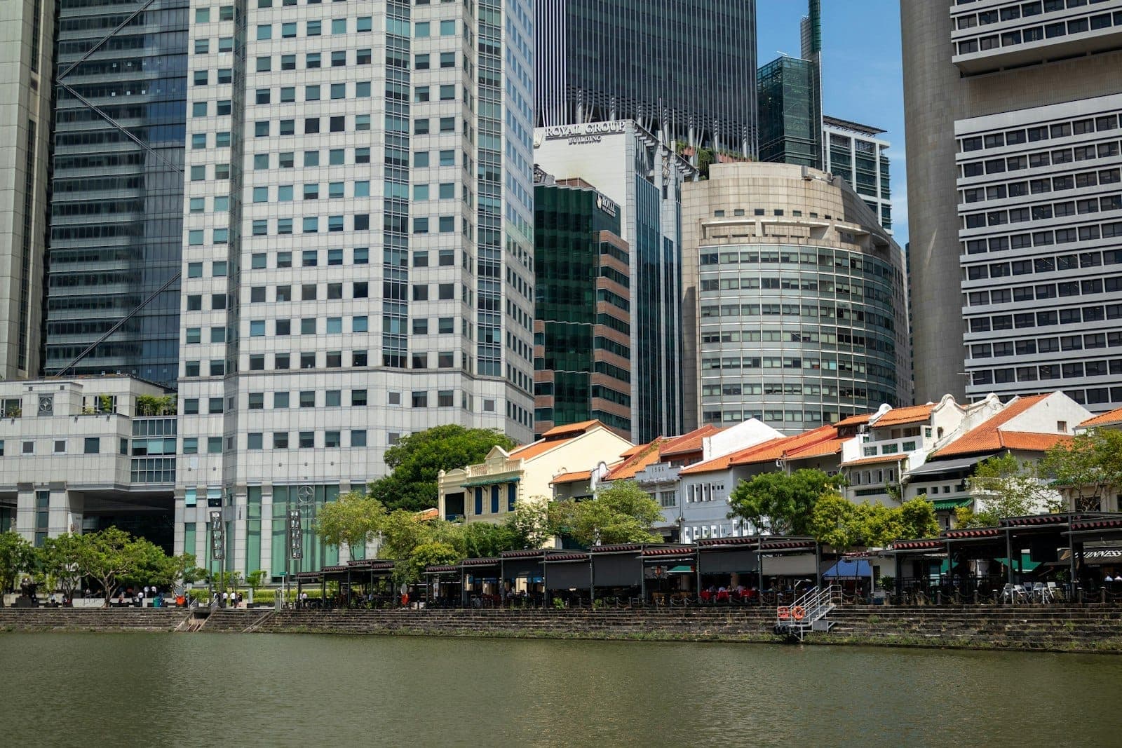
Boat Quay is a curved stretch of shophouse facades facing the Singapore River, running roughly from the base of UOB Plaza to Elgin Bridge. The two- and three-storey buildings date to the 19th century and are now conservation-listed, which means the street-level activity inside them changes constantly while the exterior remains locked in time. On any given evening you can walk from a Japanese izakaya to a Belgian beer bar to a Singapore seafood kitchen in under five minutes, all beneath the same terracotta rooflines and five-foot covered walkways.
The area is a public pedestrian zone, accessible around the clock at no charge. It is not a ticketed attraction, a museum, or a theme park. The draw is the combination of architectural character, riverside position, and a concentration of eating and drinking options that few other stretches in Singapore can match.
ℹ️ Good to know
The riverside promenade was revamped in 1989 with uniform canopies, underground cables, and added seating. It is substantially more comfortable than it used to be, and the views across to the financial district towers are now largely unobstructed from the waterfront benches.
A Port That Handled 75% of Singapore's Shipping
The history of Boat Quay is inseparable from the history of Singapore as a trading port. When Stamford Raffles drew up his town plan in 1822, he designated the south bank of the river as the area for Chinese commerce. By 1842 the district was built out, and by the 1860s Boat Quay was handling roughly 75% of Singapore's total shipping tonnage. The Hokkien community gave it multiple names reflecting different sections: Tiam Pang Lo Thau (the sampan landing), Chap Sa Kang (the 13 shops), Chap Peh Keng (the 18 houses), and Chui Chu Boi (the bathing-house end). Each name mapped a specific stretch of the waterfront and the trades that operated there.
The river itself was the logistics engine. Bumboats ferried goods between oceangoing vessels anchored in the harbor and the godowns (warehouses) lining the banks. By the late 20th century, however, the river had become severely polluted from the same commercial activity that had made it wealthy. The cleanup effort began in 1983, clearing the water and relocating the remaining boating trade. The Urban Redevelopment Authority announced conservation status for Boat Quay in 1986, and the area was formally gazetted on 7 July 1989.
The conservation designation is what saved the shophouses. Without it, the land values along the river would likely have meant demolition and redevelopment. If you want context on how this fits into Singapore's broader approach to its colonial-era built environment, the National Museum of Singapore covers the city's urban history in considerable depth.
Tickets & tours
Hand-picked options from our booking partner. Prices are indicative; availability and final rates are confirmed when you complete your booking.
Adventure Cove Waterpark™ e-ticket
From 27 €Instant confirmationWild Wild Wet Waterpark Entrance Ticket
From 15 €Instant confirmationLion City bike tour in Singapore
From 55 €Instant confirmationFree cancellationLuggage Storage in Singapore
From 7 €Instant confirmationFree cancellation
Morning, Afternoon, Evening: How the Strip Changes
At 8am on a weekday, Boat Quay is almost entirely given over to the office crowd from the surrounding financial district. A handful of cafes open early; the air smells of coffee and the river at low tide, a faint mineral-mud note that disappears once the sun climbs. The riverside paths are pleasant at this hour, quiet enough that you can hear the water and look at the shophouse facades without anyone blocking the view.
Midday brings lunch trade from nearby office towers. A few restaurants do good-value set lunches targeting that crowd; if you are eating here in the middle of the day, look for the chalkboard specials rather than the tourist-facing menus displayed outside. The heat between noon and 3pm is substantial, even under the five-foot ways. The covered walkways help but do not fully compensate.
From around 6pm the character shifts. The outdoor tables fill, string lights come on, and the reflected glow of the shophouse signage starts to ripple across the river. This is when Boat Quay looks the way it does in photographs. The background noise is a mix of conversation, occasional live music from one or two venues, and the soft engine hum of the Singapore River cruise boats passing in the dark.
💡 Local tip
The best window for photography is the 20–30 minutes after sunset, when the sky retains some blue and the restaurant lights are fully on. The contrast between the illuminated shophouses and the glass towers behind them is at its sharpest during this brief period.
Walking the Strip: What You Will Actually See
The walk from UOB Plaza end to Elgin Bridge takes about 10 minutes at an unhurried pace. The shophouses on the river side face you as you walk along the waterfront promenade; a second row of streets runs parallel inland, so the area has some depth if you want to explore beyond the main facade.
Architecturally, look for the characteristic features of Singapore shophouses: the narrow frontages (typically 4–6 metres wide), the covered five-foot walkway at ground level, and the decorative plasterwork on upper facades. Some buildings have been painted in heritage colours; others retain older, slightly faded tones. The URA conservation guidelines require that the facades be maintained without dramatic alteration, which is why the strip has a visual coherence that newer entertainment districts lack.
If you are walking from the Clarke Quay end, you will pass under Elgin Bridge and find the character softening slightly as you approach Boat Quay proper. The Singapore River cruise boards at several points along both banks and gives a different perspective on the shophouse rooflines from water level.
The promenade is flat and fully paved, which makes it accessible for wheelchairs and strollers, though the five-foot ways inside individual units vary. Footwear is not a concern during dry weather; during heavy rain the covered walkways provide reasonable shelter but the riverside tables get wet quickly.
Eating and Drinking Here: Setting Realistic Expectations
The honest summary is this: Boat Quay trades significantly on location. The prices are higher than equivalent food at a hawker centre a few blocks away, and the quality is variable. That said, some restaurants here are genuinely good, and the setting adds something real to the experience of eating in Singapore, particularly on a first visit.
The food options skew international: European restaurants, Japanese dining, and bars with Western pub menus make up a large proportion. Singaporean food is available but not dominant on this particular stretch. If local cuisine is your priority, the nearby hawker centres deliver better value.
For serious Singapore food within reasonable walking distance, Lau Pa Sat is about 10 minutes southeast and offers a far more authentic and affordable experience. For a deeper dive into local hawker culture generally, the Singapore hawker centres guide is a useful reference before you plan your meals.
The bar scene at Boat Quay runs later than many other parts of Singapore, with several venues open past midnight on weekends. The crowd on Friday and Saturday evenings is a mix of tourists, expatriates, and locals from the nearby financial sector. It is not a nightlife destination in the same sense as Clarke Quay further upstream, but it is a solid option for drinks in a setting with genuine character.
⚠️ What to skip
Be cautious of restaurants with aggressive touts or menus without prices displayed. Some establishments target tourists with inflated charges. Check that prices are clearly listed before you sit down.
Getting There and When to Go
The two most practical MRT options are Raffles Place station on the East-West line and Clarke Quay station on the North-East line. From Raffles Place, exit toward the river and walk north; the walk takes around 10 minutes. From Clarke Quay, walk south along the river path past Clarke Quay itself; allow a similar 10 minutes.
Boat Quay is very close to Merlion Park and the broader Marina Bay area, making it easy to combine into an evening walk. A loop from Merlion Park along the river to Boat Quay, then back via the business district, covers most of what a first-time visitor needs to see along the river corridor. More detail on planning that kind of itinerary is in the Singapore itinerary guide.
Weekday evenings from Monday to Thursday tend to be less crowded than weekends, with shorter waits for outdoor tables. Singapore's equatorial climate means rain is possible at any time of year; brief afternoon thunderstorms are common from November to January. The covered walkways provide partial shelter, but be prepared to move inside if a storm arrives during dinner.
Who Should Consider Skipping This
Travelers on tight budgets who want maximum food value should redirect their time to nearby hawker centres rather than Boat Quay restaurants. Those with only one or two days in Singapore may find the riverside walk worth 30 minutes as part of a broader itinerary, but it should probably not be a primary destination when competing with options like Gardens by the Bay or Chinatown.
Visitors primarily interested in authentic local food culture will get more from Maxwell Food Centre in Chinatown, which is about 15 minutes away on foot and offers a fundamentally different experience. Families with young children may find the evening bar atmosphere on weekends less comfortable, though daytime visits present no issues.
Insider Tips
- The riverside benches installed during the 1989 revamp are underused compared to the restaurant tables. Grab one at dusk with a takeaway drink and watch the cruise boats pass; it costs nothing and the view is the same.
- Walk the inland side of the shophouses (not the river-facing promenade) to see the back lanes, service entrances, and the occasional small shrine tucked between buildings. The architectural detail on the non-river facades is often more interesting and far less photographed.
- Weekday lunch sets at several Boat Quay restaurants are priced at roughly half the evening rates for largely the same food. If you want the setting without the premium, lunch on a Tuesday or Wednesday is the window.
- The riverbank reflection is best photographed from the north side of the river (the Fullerton Hotel side), looking back toward the shophouses. Most visitors photograph from Boat Quay itself, which gives a less interesting angle.
- If you hear live music drifting from a venue, it is almost always at the western end of the strip near Elgin Bridge. That cluster of bars tends to have a more local, lower-key crowd than the tourist-facing stretch closer to UOB Plaza.
Who Is Boat Quay For?
- First-time visitors who want a quick orientation to Singapore's colonial riverfront history
- Evening diners who want atmosphere as part of the meal, not just the food
- Architecture enthusiasts interested in 19th-century shophouse conservation
- Couples looking for an outdoor drinks setting with river views
- Travelers combining a walking loop with Merlion Park and the Marina Bay waterfront
Nearby Attractions
Combine your visit with:
- Clarke Quay
Clarke Quay lines the Singapore River with five blocks of conserved warehouses and shophouses, now packed with restaurants, rooftop bars, and clubs. Free to enter and active from dusk until well past midnight, it rewards visitors who arrive after dark when the neon reflects off the water and the crowds find their rhythm.
- Fort Canning Park
Standing 48 metres above the city centre, Fort Canning Park packs more history per square metre than almost anywhere else in Singapore. From ancient Malay royalty to British colonial command, the hill has shaped this island for over seven centuries — and today offers a genuinely peaceful escape just minutes from Orchard Road.
- Henderson Waves
Henderson Waves is Singapore's tallest pedestrian bridge at 36 metres above Henderson Road, connecting Mount Faber Park and Telok Blangah Hill Park along the Southern Ridges trail. Free to access at any hour, the 274-metre-long structure is equally rewarding at dawn, midday, and after dark.
- Jewel Changi Airport
Jewel Changi Airport is a 135,700 m² dome of forest, water, and commerce connecting Singapore's airport terminals. At its core stands the Rain Vortex, the tallest indoor waterfall on earth at 40 metres, surrounded by five floors of tropical greenery. Whether you have a layover or a full afternoon free, Jewel rewards the visit.