Son Tra Mountain & Ban Co Peak: Da Nang's Forested Summit Above the Sea
Rising to 696 metres above the East Sea (South China Sea), Son Tra Mountain (Núi Sơn Trà) anchors the Son Tra Peninsula northeast of Da Nang. Its highest point, Ban Co Peak (Đỉnh Bàn Cờ), rewards the climb with sweeping coastal panoramas, dense tropical forest, and surprisingly close encounters with rare Red-shanked Douc langurs. Entry is free.
Quick Facts
- Location
- Tho Quang Ward, Son Tra District, Da Nang — approx. 10 km northeast of the city centre
- Getting There
- No public bus to the summit. Ride a motorbike or hire a taxi/Grab car. Cross Dragon Bridge then follow Vo Nguyen Giap and Hoang Sa streets to the signed mountain route.
- Time Needed
- 2–4 hours for the drive up, summit visit, and return. เผื่อ a full half-day if exploring forest trails or stopping at Linh Ung Pagoda.
- Cost
- Free admission. Budget for motorbike rental or taxi/Grab fare from the city.
- Best for
- Sunrise views, wildlife spotting, motorbike day trips, photographers
What Son Tra Mountain Actually Is
Son Tra Mountain sits at the northern tip of Da Nang, on a peninsula that juts roughly 15 kilometres into the East Sea (South China Sea). The mountain's official Vietnamese name is Núi Sơn Trà, though locals and older maps still use the affectionate nickname Núi Khỉ — Monkey Mountain — a reference to the troops of Red-shanked Douc langurs that have lived here long enough to become one of the peninsula's most recognisable residents.
The summit is Ban Co Peak (Đỉnh Bàn Cờ, meaning Chessboard Peak), which rises to approximately 696 metres above sea level. From up here, Da Nang's coastline unspools in both directions: My Khe Beach stretches south, the Han River mouth glints below, and on a clear day the outline of the Hai Van Pass headland is visible to the north. The peninsula was designated a national nature reserve in 1992, covering around 4,400 hectares of subtropical forest, and that protected status is why the forest still closes in so thickly on both sides of the road as you climb.
ℹ️ Good to know
Opening hours vary by season. The tourist access roads on Son Tra Peninsula are open 07:30–18:30 from March to September, and 07:30–17:30 from October to February. Barriers are locked outside these hours except for authorised activities. Plan your descent before the closing time to avoid being caught on the mountain after dark.
The Drive Up: What to Expect on the Road
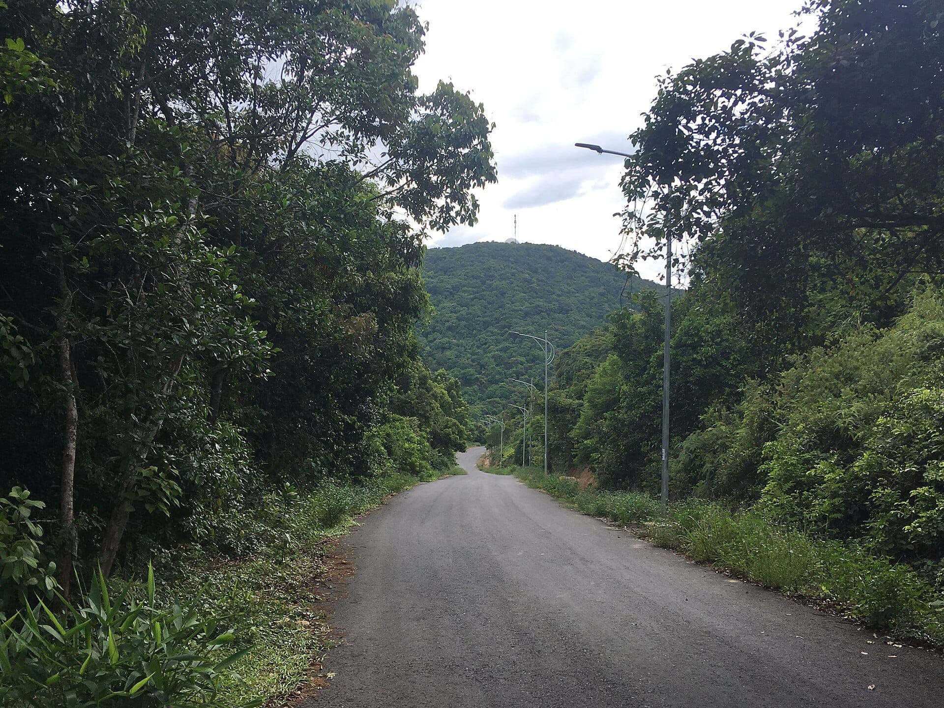
The road to Ban Co Peak begins near the peninsula's base and winds upward through a series of tight switchbacks. It is steep in places, and sections of the tarmac have been worn smooth by years of motorbike traffic and seasonal rain. Automatic scooters are restricted on certain stretches, so if you are renting one, confirm with your rental shop that your particular route and bike are permitted. Semi-automatic or manual bikes handle the gradient more comfortably.
Cars and larger vehicles can make the ascent, though overtaking on the bends requires patience. The road narrows in places, and the vegetation forms a canopy overhead that filters the light into pale green columns even in the middle of the day. In the early morning, mist sometimes settles in the hollows below the ridgeline, and the smell of damp earth and crushed leaf litter is noticeably strong before the heat burns it off.
To reach the base from central Da Nang, cross the Dragon Bridge and follow Vo Nguyen Giap Street north along the coast, continuing onto Hoang Sa Street. The turn-off for the mountain road is signed. The entire journey from the city centre takes roughly 25–35 minutes depending on traffic.
Tickets & tours
Live prices and dates from our booking partner. If you book, we may earn a commission at no extra cost to you.
Private Return Transfer from Da Nang to My Son and Marble Mountain
From 85 €Instant confirmationFree cancellation4x4 tour from Hoi An to Marble Mountain and the Son Tra Peninsula
From 75 €Instant confirmationFree cancellationPrivate Transfer from Hoi An Center to My Son and Marble Mountain
From 74 €Instant confirmationFree cancellationMarble Mountains and My Son sanctuary full-day tour with lunch
From 86 €Instant confirmationFree cancellation
At the Summit: Ban Co Peak
The final approach to Ban Co Peak involves a short climb up stairs from the parking area. The path is uneven and the steps are not uniform, so sturdy footwear matters more here than anywhere else on the peninsula. The summit itself is open enough to allow a full 360-degree panorama on a clear day, with low stone walls providing a natural vantage edge.
At 696 metres, the altitude brings a reliable breeze even when the city below is sweltering. In the dry season months from around April through August, the sky over Da Nang tends toward deep blue in the morning, and the coastal perspective — with My Khe Beach rendered as a thin pale arc against the water — is genuinely striking. A small pavilion and a few low structures occupy the summit area, including a chess set installation that references the peak's name, Bàn Cờ, meaning chessboard.
The summit is not wheelchair accessible. The combination of steep mountain roads, an unpaved final stretch, and uneven stairs makes it unsuitable for mobility aids. Visitors with limited mobility can still access lower viewpoints along the peninsular road, which offer partial coastal views without requiring the summit climb.
💡 Local tip
Arrive before 08:00 for the clearest air and fewest vehicles on the road. The light at sunrise turns the sea copper-gold from this elevation, and the langurs are most active in the cool of the morning. By mid-morning, tour groups begin arriving and the summit becomes noticeably more crowded.
Wildlife: The Douc Langurs and What Else Lives Here
Son Tra Peninsula holds one of the largest remaining wild populations of the Red-shanked Douc langur (Pygathrix nemaeus), a species listed as Endangered on the IUCN Red List. These are not habituated animals in the way that temple monkeys often are. They move through the upper canopy in family groups, the vivid rust-red of their legs and the pale grey of their torsos visible through binoculars when the vegetation is not too dense. Spotting them requires patience and quiet: stop the engine, sit still, and look up into the taller trees along the upper road.
The nickname Monkey Mountain creates an expectation of chaotic roadside animals, and that expectation is often disappointed. Sightings are real but unpredictable. Early mornings in the dry season offer the best chances, particularly in the forest sections between the mid-point rest stops and the summit. Long-tailed macaques are also present on the peninsula and are far more likely to approach the road looking for food — do not feed them, both for conservation reasons and your own safety.
Beyond mammals, the peninsula's forest supports a documented range of bird species, and birders sometimes pause at the quieter forest sections with binoculars. The dense secondary forest along the western slopes of the mountain holds more birdlife than the exposed summit ridge.
How Weather Changes the Experience
Da Nang's wet season runs roughly from September through early March, and Son Tra Mountain is significantly affected. Cloud and low mist can settle over the upper two-thirds of the mountain for hours at a time, reducing visibility at the summit to a few dozen metres. Rain makes the road surface slippery, particularly on the steeper bends, and riders who are not experienced on wet mountain roads should reconsider the trip. That said, the forest is intensely green and atmospheric in overcast conditions, and you are unlikely to have company at the summit.
The dry season from April through August delivers the most reliable summit views and the safest road conditions. For a broader picture of when to plan your Da Nang visit around weather, the best time to visit Da Nang guide covers monthly conditions in detail.
⚠️ What to skip
Check the weather before you go. If the summit is in cloud when you leave the city, it will likely still be in cloud when you arrive. A quick look at the peak from the coastal road below will tell you whether the upper section is clear before committing to the climb.
What Else Is on the Peninsula
Son Tra Mountain is the centrepiece of the peninsula, but the surrounding area holds several other worthwhile stops. Linh Ung Pagoda is actually located on the peninsula itself (not to be confused with the pagoda of the same name at the Marble Mountains), and the 67-metre-tall Lady Buddha statue visible from much of Da Nang's coastline stands at this site. The pagoda grounds are open and serene in the morning hours.
The peninsula's coastline includes several small coves and beaches accessible via side roads off the main circuit. These tend to be far quieter than My Khe Beach and are worth a stop if you have a motorbike and time to explore. The Son Tra Peninsula area guide covers the full range of options in the district.
A full half-day combining the summit drive, a stop at Linh Ung Pagoda, and a swim at one of the peninsula beaches is a reasonable and satisfying itinerary. Attempting to combine this with a morning at the Marble Mountains or an afternoon in Hoi An makes for a long day and shortcuts each experience.
Photography Notes
The summit is the obvious target, but the most interesting photographs on Son Tra Mountain often come from the road itself: sections where the jungle canopy closes overhead, the hairpin bends with sea glimpses between the trees, and the langurs in the upper forest. A telephoto lens makes a significant difference for wildlife shots.
For the coastal panorama, shoot from the summit in the first hour after sunrise or in the last 30 minutes before sunset when the low angle of light defines the headlands and gives the sea texture. Midday light at this elevation is harsh and flattens the coastal detail. Bring a polarising filter if you want the water to show its true blue-green rather than washing out.
If you are building a broader photography day around Da Nang's viewpoints, the Da Nang viewpoints guide includes comparisons of Ban Co Peak with other elevated perspectives around the city.
Insider Tips
- The road to the summit has two main approaches. The eastern route is generally better maintained and more commonly used by tourists. Ask your hotel or rental shop which route is currently open for your bike type, as restrictions can change.
- There is minimal food or drink available at the summit. Bring water — at least one litre per person — because the drive up is warm and the summit breeze can be deceptive about how much you are sweating.
- If the main summit viewpoint is crowded, a short walk along the ridge path brings you to less-visited spots with comparable views and far fewer people in your photographs.
- Military infrastructure occupies parts of Son Tra Peninsula. Do not photograph military buildings, radar installations, or personnel. Stick to the designated tourist roads and viewpoints.
- Combine the summit visit with an early morning stop at Linh Ung Pagoda on the way down. The pagoda is at its quietest before 09:00, and the Lady Buddha statue catches the morning light from the east.
Who Is Son Tra Mountain & Ban Co Peak For?
- Motorbike riders looking for a scenic half-day loop from the city centre
- Wildlife enthusiasts hoping to spot Red-shanked Douc langurs in the wild
- Photographers seeking elevated coastal panoramas at golden hour
- Travellers who want a break from the beach without leaving Da Nang
- Couples and small groups looking for a self-guided adventure that doesn't require a tour
Nearby Attractions
Other things to see while in Son Tra Peninsula:
- Lady Buddha Statue (Linh Ung Bai But Pagoda)
Standing 67 metres above the coastline of Son Tra Peninsula, the Lady Buddha statue at Linh Ung Bai But Pagoda is Da Nang's most recognisable landmark. The pagoda grounds are free to enter, beautifully maintained, and open daily from 06:00 to 21:00, making them one of the most accessible spiritual and scenic sites in central Vietnam.
- Son Tra Night Market
Son Tra Night Market, known locally as Chợ Đêm Sơn Trà, is a free-entry pedestrian market spread across nearly 200 stalls on the east bank of the Han River, minutes from the Dragon Bridge. It runs nightly from around 5:30 PM and draws a mix of locals shopping for produce, tourists hunting for souvenirs, and visitors eating their way through Vietnamese street food. It is unpretentious, affordable, and genuinely lively after dark.
- Son Tra Peninsula Beaches
The beaches of Son Tra Peninsula sit inside a protected nature reserve on the northeastern edge of Da Nang, roughly 10 km from the city center. Unlike the wide resort strips of My Khe, these coves are compact, largely undeveloped, and backed by dense jungle rather than hotel towers. Entry is free, and the water is generally clear outside of storm season.
Planning a trip? Discover personalized activities with the Nomado app.