Salina Island: The Aeolian Archipelago's Green, Unhurried Alternative
Salina is the second-largest of the Aeolian Islands, shaped by twin extinct volcanoes and unusually lush vegetation compared to its neighbours. It produces the archipelago's finest Malvasia dessert wine, grows some of Sicily's best capers, and attracts visitors who want genuine island life over day-trip crowds.
Quick Facts
- Location
- Salina, Aeolian Islands, Province of Messina, Sicily, Italy (98050 ME)
- Getting There
- Hydrofoil or ferry from Milazzo or Messina on mainland Sicily; also connected to other Aeolian Islands. Main ports: Santa Marina Salina and Rinella.
- Time Needed
- Minimum 2 full days; 4-5 days to explore properly at a relaxed pace
- Cost
- No admission fee to the island itself. Ferry/hydrofoil tickets priced separately by operator; verify current fares directly with carriers before travel.
- Best for
- Hikers, food and wine lovers, couples, photographers, and anyone seeking a slower Aeolian experience
- Official website
- http://www.comunesantamarinasalina.it
What Makes Salina Different From the Other Aeolian Islands
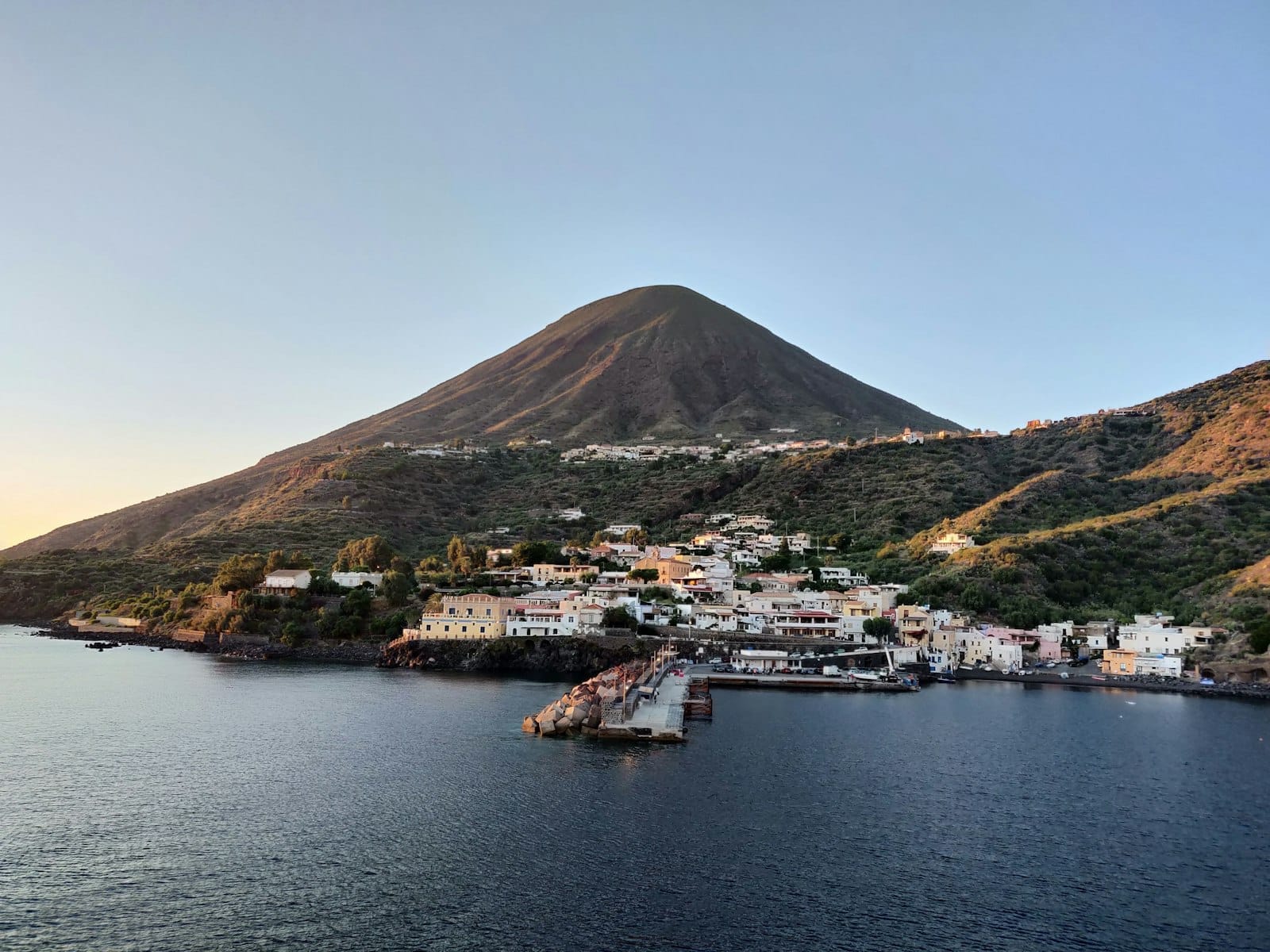
Salina Island sits at the geographic heart of the Aeolian archipelago, roughly equidistant from the fire-and-lava drama of Stromboli to the northeast and the sulphurous mud pools of Vulcano to the south. At about 26.4 km², it is the second-largest island in the group, but in character it feels like a separate world. Where many Aeolian islands are brown, rocky, and almost lunar in their dryness, Salina is green. Genuinely, surprisingly green.
Two extinct volcanoes, Monte Fossa delle Felci (962 m) and Monte dei Porri (860 m), give Salina its twin-peak silhouette visible from the ferry long before you dock. The ancient Greeks named the island Didyme, meaning "the twin," for exactly this reason. The height of these peaks forces passing clouds to release their moisture here rather than further south, producing a microclimate that supports vineyards, caper bushes, and dense fern forest that the neighbouring islands cannot sustain.
The name Salina itself comes from a small inland lake historically used for salt extraction, a trade that has long disappeared but left its name on maps and in local memory. Today the island's economy turns on Malvasia delle Lipari wine, capers, fishing, and tourism that, by comparison with Lipari or Vulcano, remains measured and manageable.
ℹ️ Good to know
Salina has no general admission fee. The island is a public destination accessible year-round. What you pay for is the ferry or hydrofoil crossing. Always confirm current schedules and fares directly with operators such as Liberty Lines or Siremar before travel, as services and prices change seasonally.
Arriving and First Impressions
Most visitors arrive at Santa Marina Salina, the main village on the east coast and the island's de facto commercial centre. The port is small enough that you can see the whole seafront in a single glance: a row of low-rise buildings in pale yellow and terracotta, a scattering of fishing boats, and bars that open early for espresso and brioche. The atmosphere is unhurried in a way that feels structural rather than performed. Salina simply does not have the infrastructure for the kind of high-turnover tourism that transforms other Mediterranean islands.
A second port, Rinella, sits on the southwestern coast and handles some ferry traffic, particularly services connecting from Palermo and the western Aeolian islands. Arriving at Rinella gives you a quieter first impression: a small fishing cove, a bar on the waterfront, and the feeling that the rest of the island requires deliberate effort to reach. Both ports are worth knowing, since wind conditions occasionally redirect ferries from one to the other.
On the dock at Santa Marina in the early morning, the air carries salt and something organic, the faint green smell of vegetation unusual for a volcanic island. By midday in July or August, temperatures in the villages reach the high twenties Celsius, and the pace slows accordingly. Most movement happens before noon and again after five in the afternoon. Anyone arriving expecting a resort rhythm will need to recalibrate.
Tickets & tours
Hand-picked options from our booking partner. Prices are indicative; availability and final rates are confirmed when you complete your booking.
Lipari and Salina boat tour with stops
From 47 €Instant confirmationFree cancellationEtna South Upper Craters Guided Excursion from Taormina
From 42 €Instant confirmationFree cancellationTaormina private tour with an expert guide
From 42 €Instant confirmationFree cancellationIsola Bella boat tour and snorkeling
From 55 €Instant confirmationFree cancellation
The Villages: Six Small Centres, Each With Its Own Character
Salina is divided among three municipalities—Santa Marina Salina, Malfa, and Leni—with six main population centres including smaller villages such as Lingua, Rinella, and Pollara. None of them is large. Together they form a loose circuit that can be explored by rental scooter, car, or the island's local bus service, though the roads are narrow and steep in places.
Lingua, a short walk or drive south of Santa Marina, clusters around a lagoon that was once the salt production site the island is named for. It is famously associated with the best granita on the archipelago: Alfredo's bar in the village has been cited by food writers and locals alike for decades. The granita here is made with real almonds or fresh fruit, and eating one on the lagoon wall watching the light shift over the water is the kind of simple experience Salina does very well.
Pollara, on the northwestern coast, occupies a volcanic crater and looks out over a near-perfect semicircular bay with steep reddish cliffs dropping into the sea. The beach at Pollara is small and reached by a steep path, but the view from the crater rim above is one of the most photographed in the Aeolian Islands. The 1994 Italian film Il Postino was partially filmed here, and the connection brings a trickle of literary-minded visitors each summer. Malfa, on the north coast, is quieter still and draws those looking for upscale accommodation and a more secluded beach at Punta Scario.
Hiking: Monte Fossa delle Felci and the Nature Reserve
The ascent of Monte Fossa delle Felci, at 962 metres the highest point in the Aeolian archipelago, is the defining physical experience on Salina. The most commonly used trail begins near the sanctuary of Madonna del Terzito, between Valdichiesa and Leni, and climbs through vineyards before entering the protected forest zone. Here the path is shaded by tree heather, ferns, and holm oak, and the sounds of the lower island, scooters, boat engines, conversation, fade completely.
The summit requires a moderate level of fitness and appropriate footwear. The terrain is uneven volcanic rock in places, and the upper section is exposed. On a clear morning, which is most mornings from May through October, the panorama from the top takes in every Aeolian island simultaneously: Stromboli's cone to the northeast, Panarea's scattered rocks below it, Lipari and Vulcano to the south, Filicudi and Alicudi to the west. Allow three to four hours for the round trip from the sanctuary.
💡 Local tip
Start the Fossa delle Felci hike no later than 7:30am in summer. The summit section has no shade, and by 10am the heat on exposed rock becomes genuinely draining. Bring at least 1.5 litres of water per person; there are no facilities on the trail.
A large portion of Monte Fossa delle Felci and surrounding terrain is protected as a nature reserve, preserving the unique ecosystem that sets Salina apart from the rest of the archipelago. For context on other natural walking landscapes in Sicily, the Zingaro Nature Reserve on the mainland offers a comparable commitment to protected walking terrain, though the landscapes are quite different.
Malvasia Wine and Capers: What Salina Tastes Like
Salina produces Malvasia delle Lipari DOC, one of the most distinctive dessert wines in Italy. The Malvasia Bianca grape, grown on the island's volcanic slopes, produces a wine that is amber-gold, sweet but with enough acidity to avoid cloying richness, and carries notes of apricot, dried citrus peel, and a faintly smoky mineral quality that comes from the soil. It is typically served in small glasses alongside almond biscuits or pastries at the end of a meal.
Several small producers offer informal tastings. The names most frequently associated with quality production include Hauner and Fenech, both of which have been operating on the island for decades. Picking up a bottle at the source and understanding where each vineyard sits in relation to the two volcanic peaks is a more satisfying experience than reading about the wine afterward. For a broader picture of Sicilian wine culture, the Sicily wine guide covers the major regions and grape varieties across the island.
Salina capers are equally serious. The island's capers are considered among the finest in Sicily, salted rather than brined, which preserves their sharp, floral intensity. You will find them in nearly every dish served on the island: pasta, insalate, grilled fish. Small bags of salted capers make practical and genuinely useful gifts. Look for them in the small alimentari shops in Santa Marina and Malfa rather than at tourist-facing stalls, where prices are higher and provenance less certain.
Beaches and Swimming
Salina's beaches are not its strongest suit if you are comparing them with sandy stretches elsewhere in the Mediterranean. The coastline is predominantly dark volcanic rock and pebble, with a few small shingle beaches. That said, the water clarity around the island is exceptional. The absence of large tourist infrastructure means boat traffic is relatively low, and visibility underwater is often measured in tens of metres.
Punta Scario near Malfa and the beach at Pollara are the most photographed spots. The approach to Pollara beach is a steep descent on foot, and the beach itself is small, but the enclosed crater bay creates an almost theatrical setting. Rinella has a slightly larger, more accessible beach popular with families staying in that part of the island. For the best snorkelling, the rocky outcrops around the northern coast are more rewarding than any individual beach.
⚠️ What to skip
Salina's terrain is steep and volcanic. The paths to several beaches involve uneven stone steps and loose rock. Flip-flops are inadequate for anything beyond the immediate waterfront. Bring water shoes for swimming from rocky entries, and closed shoes for any path that climbs away from the coast.
When to Visit and How the Island Changes by Season
The practical window for visiting Salina runs from late April through October, when ferry connections are reliable and most accommodation and restaurants are open. The peak summer months of July and August bring the island's highest visitor numbers, though Salina remains significantly quieter than Lipari during this period. For a broader look at timing across the region, the best time to visit Sicily covers seasonal factors island-wide.
May and June offer the most comfortable conditions for hiking: daytime temperatures in the low to mid-twenties Celsius, the vegetation at its most lush, and the tourist season not yet at full volume. September is similarly appealing, with the added advantage of warm sea temperatures from the summer's accumulated heat and significantly fewer visitors than August. The light in September and October has a particular quality, lower and warmer in tone, that rewards photography.
From November through March, Salina becomes a very different place. Many restaurants and hotels close entirely. Ferry services reduce to a fraction of the summer schedule and can be cancelled due to rough weather, sometimes for days at a stretch. The island reverts to its year-round population of a few hundred residents. Visiting in winter is possible, but requires flexibility, self-sufficiency, and an acceptance that most of what makes Salina appealing to visitors will be unavailable.
Practical Walkthrough: Getting Around the Island
Salina has no airport. All arrivals are by sea. From Milazzo, on the north-east Sicilian coast west of Messina, hydrofoils reach Santa Marina Salina in around 90 minutes; conventional ferries take longer. From Messina, the crossing is also available but less frequent. Services connect Salina to all the other Aeolian Islands, making it feasible to use Salina as a base for day trips to Lipari, Panarea, or even Stromboli, subject to weather and seasonal timetables.
Within the island, renting a scooter or small car at the port is the most practical option for independent exploration. The circuit road connecting the main villages is about 20 km in total. Local buses do run between villages on a fixed schedule, but services are infrequent and timed around local rather than tourist needs. Taxis and private transfers are available but should be arranged in advance during peak season.
If you are planning Salina as part of a wider Aeolian circuit, the Sicily island hopping guide outlines how to sequence the islands efficiently, including which ports and ferry operators serve each connection.
Insider Tips
- The bus from Santa Marina to Pollara is infrequent and does not always coincide with sunset. If you want to photograph the crater bay in the late afternoon light, rent a scooter or negotiate a return transfer in advance. The walk back from Pollara to Malfa is scenic but long and has no lighting.
- Malvasia is sweet and goes down easily in the warmth of a summer evening. The alcohol content is higher than it tastes; typically 13-15% for the passito style. Order a small glass with food rather than treating it like a table wine.
- The alimentari in Malfa and Lingua stock locally salted capers sold by weight at prices substantially below what you will pay in the Santa Marina port shops. Bring a small container or ask for double-wrapped bags if you are flying onward.
- Wind is the variable that most disrupts Aeolian travel plans. The scirocco from the south and the tramontane from the north can both close the hydrofoil service without much notice. Build a buffer day into your itinerary if you have a fixed departure from the mainland.
- For the Fossa delle Felci hike, the trailhead near the Madonna del Terzito sanctuary has limited parking and no facilities. The small bar in Valdichiesa, a short walk away, opens early and is the best place to fill water bottles before the ascent.
Who Is Salina For?
- Hikers and naturalists who want volcanic terrain with genuine forest cover and panoramic summit views
- Food and wine travellers focused on Malvasia delle Lipari DOC and authentic caper production
- Couples looking for a quieter Aeolian base with good restaurants and fewer crowds than Lipari
- Photographers drawn to the Pollara crater bay, the twin volcanic peaks, and the quality of late-season light
- Travellers using an island base to make day trips by hydrofoil to Stromboli, Panarea, and Lipari
Nearby Attractions
Other things to see while in Aeolian Islands:
- Lipari
Lipari is the largest and most accessible of Sicily's Aeolian Islands, a UNESCO World Heritage volcanic archipelago in the Tyrrhenian Sea. From its towering citadel and world-class archaeological museum to obsidian-streaked cliffs and crystalline coves, Lipari rewards travelers who want more than a beach stopover.
- Panarea
Panarea is the smallest of the seven inhabited Aeolian Islands, a car-free volcanic outcrop in the Tyrrhenian Sea with a surface area of just 3.4 km². part of a UNESCO World Heritage Site for its geological significance, it draws travelers who want crystalline water, dramatic terrain, and an atmosphere that feels genuinely removed from the mainland. It is also, by Aeolian standards, one of the priciest places to stay in Sicily.
- Stromboli
Stromboli is one of the world's most persistently active volcanoes, erupting small bursts of lava and ash typically every 20–30 minutes around the clock. Part of the Aeolian Islands UNESCO World Heritage Site, it draws travelers willing to reach a genuinely remote place in exchange for an experience that is difficult to match anywhere in Europe.
- Vulcano
Vulcano is the southernmost of Sicily's Aeolian Islands and the one that delivers the archipelago's volcanic drama most directly. From the rim of the Gran Cratere to the sulphurous mud baths at Porto di Levante, this compact island packs an intense sensory experience into a small footprint. It rewards a full day, and for those who stay overnight, it reveals a quieter, more elemental side after the day-trippers leave.