Plaza San Martín: Retiro's Grand Civic Park
Plaza San Martín is the defining green space of the Retiro neighborhood, framed by some of Buenos Aires' most striking early 20th-century buildings. Free, open around the clock, and rich in political history, it rewards a slow walk at almost any hour of the day.
Quick Facts
- Location
- Retiro, Buenos Aires (bounded by Av. del Libertador, Maipú, Av. Santa Fe, and Av. Leandro N. Alem)
- Getting There
- Subte Line C to San Martín or Retiro stations; also served by Retiro commuter rail terminal and dozens of bus lines
- Time Needed
- 30–60 minutes for the park itself; 2+ hours if you explore the surrounding buildings
- Cost
- Free – public park, no admission fee
- Best for
- Architecture lovers, history seekers, midday breaks, evening strolls
- Official website
- turismo.buenosaires.gob.ar/en/atractivo/plaza-san-mart%C3%ADn
What Plaza San Martín Is
Plaza San Martín is a large public park and civic square occupying a prominent elevated terrace at the northern end of Buenos Aires' historic center. It sits in the Retiro district, flanked on all sides by buildings that read like a catalog of the city's early 20th-century architectural ambition: the Edificio Kavanagh, the Círculo Militar (formerly Palacio Paz), and the Torre Monumental (once known as the British Clock Tower) all face the square or sit within a short walk. The park itself is free to enter and open at all hours, making it equally useful as a 7 a.m. bench-and-coffee spot and a 10 p.m. evening circuit.
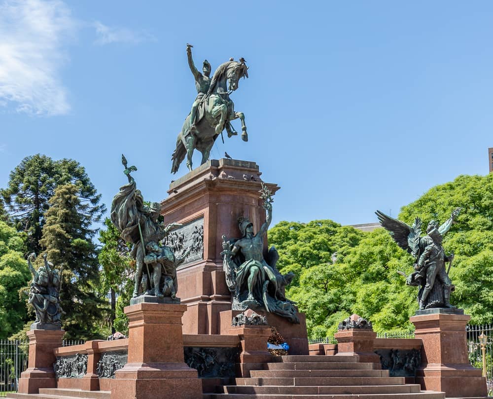
The square is named for General José de San Martín, the liberator of Argentina, Chile, and Peru, whose equestrian statue stands at its center. This is not just a decorative monument: the site carries ceremonial weight, and state events, military commemorations, and political demonstrations have all taken place here across Argentina's turbulent modern history.
ℹ️ Good to know
Plaza San Martín is generally accessible at all hours, with free admission. Occasional temporary closures may occur for civic ceremonies or maintenance.
The Landscape: What You Actually See
The park occupies sloping ground that drops from Avenida Santa Fe at the south toward the lower level near the Torre Monumental to the northeast. This topography gives the square an unusual sense of depth for a city-center park. As you descend from the main upper terrace, the tree canopy thickens, and the urban noise from the surrounding avenues softens noticeably.
The vegetation is one of the park's understated strengths. Massive rubber trees (Ficus elastica) with aerial root systems, jacarandas that drop purple flowers across the paths in November, and a variety of subtropical species create real shade. In summer, the canopy temperature can feel several degrees cooler than the surrounding pavement, which matters in a city where January afternoons regularly push past 30°C.
Gravel and paved paths criss-cross the park, with benches placed at intervals under the larger trees. The paths are generally level enough for wheelchairs within the park itself, though the surrounding streets and some older kerb stones nearby are uneven. Entrance ramps are available at major access points.
The park's lower northeastern edge opens toward the Torre Monumental and the Retiro transport hub. From this vantage point, you get an unusual angle on the Torre Monumental, a 75-meter neo-Gothic clock tower donated by the British community in 1916, visible above the treeline.
Tickets & tours
Live prices and dates from our booking partner. If you book, we may earn a commission at no extra cost to you.
Walking private tour of Plaza de Mayo and San Telmo
From 38 €Instant confirmationFree cancellationMadero Tango Show tickets with optional dinner
From 32 €Instant confirmationFree cancellationBuenos Aires small-group city tour with optional lunch and cruise
From 25 €Instant confirmationFree cancellationPiazzolla Tango Show VIP tickets with transfer and optional dinner
From 112 €Instant confirmationFree cancellation
The Architecture Around the Square
The buildings that face Plaza San Martín are the main reason architecture enthusiasts put this square on their itinerary. Standing in the park and turning a slow 360 degrees gives you a compressed survey of the building confidence Buenos Aires had at the turn of the 20th century, when the city was among the wealthiest in the world.
The Círculo Militar, occupying the site formerly known as Palacio Paz, is one of the largest private residences ever built in Argentina, completed in 1914. Its French Second Empire facade is monumental without being overwhelming. Nearby, the Edificio Kavanagh presents an interesting contrast: a 1936 Art Deco rationalist tower that was, at the time of its completion, the tallest reinforced-concrete building in South America. These two buildings alone span three decades of completely different aesthetic philosophies, both visible from the same park bench.
If the architectural density of this area sparks a broader interest in the city's built environment, the Buenos Aires architecture guide covers the full spectrum from colonial Microcentro to modernist Palermo.
How the Park Changes by Time of Day
Early mornings, roughly 7 to 9 a.m., bring office workers cutting through on their way to Retiro station and a handful of runners completing circuits on the upper terrace. The light at this hour hits the Edificio Kavanagh from the east, illuminating its stepped crown in a way that afternoon photographs rarely capture. The park is uncrowded, the air cooler, and the birdsong from the rubber trees is genuinely prominent.
By midday, particularly on weekdays, the benches fill with workers eating lunch brought from nearby takeaways. Groups of school students on excursions sometimes gather around the San Martín monument. The square is social but not chaotic, and the noise level stays at a comfortable ambient hum rather than a roar.
Late afternoon to early evening is the most photogenic window for the surrounding facades. The warm westerly light wraps around the Círculo Militar and catches the carved stone details. Families with children appear, and the dog-walking population of Retiro treats the lower park paths as a late-afternoon routine. After dark, the square is lit and reasonably active, though the pace drops considerably after 10 p.m. on weeknights.
💡 Local tip
For the best combination of light and atmosphere, visit in the hour before sunset: the facades are warm-lit, the park is populated but not packed, and the jacarandas (in season, October to November) are at their most striking.
Historical and Cultural Context
The site now occupied by Plaza San Martín was previously known as Plaza de las Catalinas, named for a Catalonian religious community that held land in the area during the colonial period. It served various civic and military purposes across the 18th and 19th centuries before being redesigned as a formal public garden.
The square's current layout owes much to Charles Thays, the Franco-Argentine landscape architect who shaped many of Buenos Aires' parks and gardens in the late 19th and early 20th centuries. Thays favored naturalistic plantings over rigid symmetry, which is why the square feels more like a real park than a formal European plaza. The same designer was responsible for the Jardín Botánico in Palermo.
One significant feature at the lower end of the square is the Monumento a los Caídos en Malvinas, the memorial to Argentine soldiers who died in the 1982 Falklands War. The names of the fallen are engraved on black panels, and an eternal flame burns nearby. The memorial receives quiet, respectful visitors throughout the day and is particularly significant on the anniversary dates of the conflict, when formal ceremonies take place.
Plaza San Martín sits at the edge of the Retiro neighborhood, which is also home to the city's largest transport hub. Understanding the Retiro district as a whole helps make sense of the plaza's position at the meeting point between the historic civic center and the modern city.
Getting There and Getting Around
The plaza is one of the most accessible points in Buenos Aires by public transport. Subte Line C serves both Retiro station and San Martín station, both within a short walk of the square's perimeter. The Retiro commuter rail terminal, the largest in the city, connects to suburbs on the Mitre, Belgrano R, and San Martín lines and is within 5 minutes on foot. Dozens of colectivo (bus) routes stop on the surrounding avenues.
The SUBE card, a rechargeable fare card available at kioscos and some metro stations, is needed for buses and the Subte. If you do not have one, acquiring it early in your trip will save repeated inconvenience. Fares are low by international standards, though the exact amount changes frequently; check current rates before traveling.
⚠️ What to skip
Avenida del Libertador and Avenida Leandro N. Alem, which bound the northern and eastern sides of the plaza, are heavy traffic corridors. Use the signalized crossings and allow extra time when crossing from the train or bus on foot.
If you are building a walking route through the city center, Plaza San Martín connects naturally southward along pedestrian Florida Street toward the Obelisco and Avenida de Mayo, making it an easy starting or finishing point for a full downtown circuit.
Photography Notes and Practical Tips
The Edificio Kavanagh photographs best from the lower terrace of the park looking northeast: its tapering Art Deco profile comes into full view without being blocked by trees. A wide-angle lens or the wide mode on most smartphone cameras is useful here. For the San Martín equestrian monument, late afternoon gives the softest directional light from the west.
The Malvinas memorial is a place where quiet and discretion are appropriate. While there is no formal restriction on photography, visitors should be aware that people come here to grieve and reflect. Treat it the way you would any war memorial.
Weather affects the experience more than most guidebooks acknowledge. In summer (December to February), midday heat combined with high humidity can make a park visit uncomfortable between noon and 3 p.m. Spring (September to November) and autumn (March to May) give more pleasant ambient temperatures for a slow walk, with October and November having the added visual bonus of the jacaranda bloom. The park has minimal shade at its higher, more open terrace sections, so a hat and water are sensible in summer.
Who Might Not Enjoy This
If your goal is a structured indoor experience with labeled exhibits, Plaza San Martín will feel unresolved: it is a park, and its meaning is largely contextual. Travelers with very limited time who are prioritizing museums or tango venues might spend that time more productively elsewhere. The park is also not remarkable after dark for anyone seeking nightlife: by 11 p.m. it is quiet, and the surrounding area is commercial rather than social.
The plaza is also sometimes described as a gateway to Retiro rather than a destination in itself. This is partly fair: much of the value here comes from using it as an organizing point for walking to nearby buildings rather than treating it as the main event. If you are short on time, a 20-minute pass through on the way to or from the Retiro transport hub captures most of what the square offers.
Insider Tips
- The Círculo Militar occasionally opens parts of its interior to the public, including its grand halls and small museum. Check their schedule in advance if you want to see the inside of what was once the Palacio Paz, one of the most opulent private residences in Argentine history.
- For the Malvinas memorial, the most meaningful time to visit is April 2, the anniversary of the 1982 landing, when official commemorations take place. Outside of that date, early morning visits are the quietest.
- The upper terrace near the San Martín statue is a reliable spot to watch the city's office rhythm: the surge of pedestrians from Retiro station between 8 and 9 a.m., and the reverse flow at 6 p.m., is a compressed portrait of how Buenos Aires moves.
- Jacaranda season (October to November) covers the gravel paths in purple flowers that photograph well against the grey stone facades. This is one of the few times the park looks genuinely different from week to week.
- Florida Street, the pedestrian shopping corridor, runs from the southern edge of the plaza all the way to Avenida de Mayo. Walking it in full gives a useful north-to-south cross-section of the historic center without spending a peso.
Who Is Plaza San Martín For?
- Architecture enthusiasts who want to compare Art Deco and Beaux-Arts buildings in a single visit
- History-focused travelers interested in Argentine independence and the Malvinas conflict
- Visitors building a walking route through the central city who need a navigational anchor point
- Photographers seeking morning light on the Edificio Kavanagh or autumn jacaranda coverage
- Travelers arriving or departing via Retiro who have an hour to spare between connections
Nearby Attractions
Other things to see while in Retiro:
- Edificio Kavanagh
Completed in 1936, the Edificio Kavanagh was once the tallest skyscraper in Latin America and the largest reinforced concrete structure in the world. Today it stands in Retiro as a landmark of Art Deco architecture, best appreciated from the adjacent Plaza San Martín at different times of day.
- Museo de Arte Hispanoamericano Isaac Fernández Blanco
Housed inside the extraordinary Palacio Noel, a 1920s Spanish Colonial Revival mansion in Retiro, the Museo de Arte Hispanoamericano Isaac Fernández Blanco holds Buenos Aires' most important collection of colonial silverwork, religious imagery, and period furniture spanning the 16th to 19th centuries. It is quieter, more focused, and ultimately more rewarding than many of the city's larger art institutions.
- Palacio Paz (Círculo Militar)
Built for a press baron and completed in 1914, Palacio Paz is the largest private residence ever constructed in Argentina. Today operated by the Círculo Militar, it opens its gilded salons to guided tours that reveal a Belle Époque interior of staggering scale, matched by an important national arms museum on the premises.
- Torre Monumental (Torre de los Ingleses)
Standing at the edge of Retiro since 1916, the Torre Monumental is a gift from the British community to Argentina and one of the few publicly accessible viewpoints in central Buenos Aires. Foreign visitors pay a modest admission fee. The clock tower rises about 50 metres above the plaza, offering clear sightlines over the city's roofline, the river, and the web of commuter rail lines below.
Planning a trip? Discover personalized activities with the Nomado app.