Mount Batur: Bali's Iconic Sunrise Volcano Trekking Experience
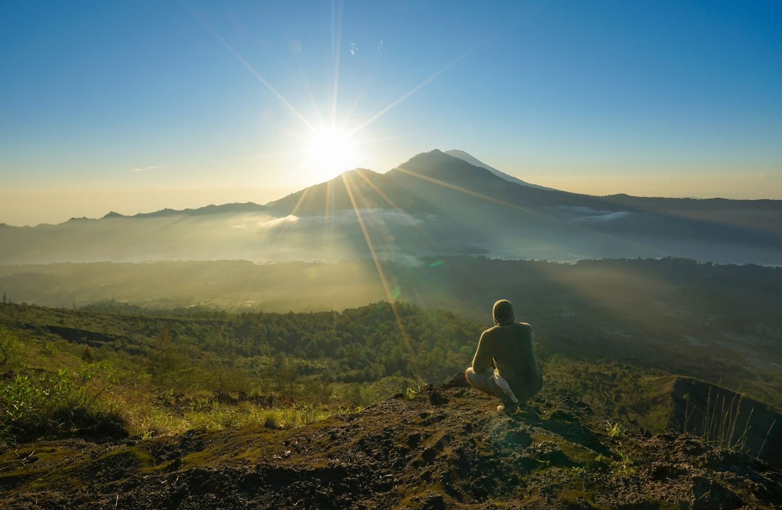
Mount Batur is an active 1,717-metre volcano in Bali's highland interior, drawing thousands of hikers each year for its pre-dawn ascent and extraordinary crater-rim sunrise. The two-hour climb rewards visitors with sweeping views over Lake Batur, Mount Agung, and, on clear mornings, the distant silhouette of Mount Rinjani on Lombok.
Quick Facts
- Location
- Kintamani District, Bangli Regency, Bali (approx. 2 hours north of Ubud)
- Getting There
- Private car or scooter to Toya Bungkah village (main trailhead). No public transit. Most visitors book a guided tour with hotel pickup.
- Time Needed
- 5–7 hours total: depart 2–3 AM, summit by sunrise (~5:30–6:00 AM), descend and breakfast by 10 AM
- Cost
- Guided sunrise trek typically IDR 350,000–550,000 per person (includes guide fee). Independent hiking strongly discouraged and subject to local guide association rules.
- Best for
- Hikers, sunrise chasers, volcano enthusiasts, photographers
What Mount Batur Actually Is
Mount Batur (Gunung Batur) is an active stratovolcano sitting inside a massive ancient caldera, one of the largest in Southeast Asia. The caldera itself formed roughly 29,300 years ago during a cataclysmic eruption. The younger cone that visitors climb today has erupted more than 20 times since 1804, most recently in 2000. Lava fields from the 1968 eruption are still clearly visible on the northeastern slopes: broad, grey-black sheets of hardened basalt that cut through the surrounding scrub and feel startlingly raw underfoot.
The UNESCO Global Geopark designation granted to the Batur caldera region in 2012 reflects its geological significance, not just its photogenic quality. Lake Batur, filling the caldera floor few hundred meters below the main summit, is Bali's largest lake and a critical freshwater source for the island's southern rice paddies. When you stand on the rim at dawn, you're looking at a living geological system, not a scenic backdrop.
The Climb: What to Expect Hour by Hour
Most guided groups leave their accommodation or a designated meeting point in the Kintamani area between 2:00 and 3:00 AM. The darkness is not incidental: the goal is to be on the summit before first light, which typically arrives between 5:30 and 6:00 AM depending on the season. Headlamps are essential. The path starts through thin forest and transitions quickly onto open volcanic scree, where the trail steepens sharply.
The ascent takes roughly 1.5 to 2 hours at a moderate pace. The trail is not technical: there are no ropes or equipment required. But the loose volcanic gravel on the upper third demands attention, particularly in the dark. Footing is better on the left-side path from Toya Bungkah than on some of the steeper alternative routes. Fitness matters: the final 30 minutes involve a sustained push at altitude, and the thin, cool air at the top (temperatures regularly drop to 10–15°C before dawn) sharpens the contrast with the tropical heat below.
💡 Local tip
Bring a wind layer and warm gloves. Temperatures at the summit can feel close to freezing before sunrise, especially in July and August when Bali's dry-season winds are strongest. A light fleece plus a wind shell is sufficient for most hikers.
At the top, guides from some groups carry eggs and bananas to cook in the natural steam vents near the crater edge, a widely photographed ritual that has become part of the Batur experience. It is memorable, if a little theatrical. The steam itself is real: you can feel warmth rising from fumaroles along the crater rim, and the sulphurous smell is faint but unmistakable.
Tickets & tours
Hand-picked options from our booking partner. Prices are indicative; availability and final rates are confirmed when you complete your booking.
Guided Mount Batur sunrise hike plus natural hot springs
From 50 €Instant confirmationFree cancellationFull-day scenic Ubud and Kintamani Volcano tour
From 60 €Instant confirmationFree cancellationMount Batur jeep private tour with breakfast at sunrise
From 59 €Instant confirmationFree cancellationMount Batur sunrise trekking with private guide
From 60 €Instant confirmationFree cancellation
Sunrise at the Summit: The Real Reward
The sunrise from Mount Batur is genuinely exceptional, with some honest caveats. On clear mornings from May through September, the view is multi-layered: the dark caldera lake, the broad flatlands of central Bali stretching south toward the sea, and the dominating mass of Mount Agung (Bali's highest and most sacred volcano at 3,031 metres) rising to the east. The light arrives in stages, starting as a pale gold line on the horizon and gradually flooding the caldera in warm amber.
Cloud cover is the main variable. During Bali's rainy season (October through March), the summit is frequently socked in by the time the sun rises, producing a white-out rather than a panorama. The experience can still feel atmospheric, but you may see nothing beyond 20 metres. If a clear sunrise is your primary goal, plan your hike for the dry season and check the forecast the evening before.
For full context on when to visit Bali to maximise your chances of clear highland conditions, the best months to visit Bali guide breaks down seasonal weather patterns in detail.
By 7:00 AM, the summit area is crowded. By Bali standards, this is a high-traffic attraction: dozens of groups arrive at roughly the same time, which means the crater rim can feel busy during the golden hour window. The crowds thin out noticeably by 8:00–8:30 AM as groups begin their descent, giving late risers on the summit a quieter, warmer experience, but missing the best light.
Guides, Safety, and the Local Association
The Batur Guide Association (PPPGB) controls access to the mountain and requires all hikers to use a registered local guide. This is not optional: hikers who attempt to climb independently have been turned back at the trailhead. The requirement is enforced consistently. While the mandatory guide system is occasionally criticised by independent-minded travellers, it also means the trails are maintained, safety incidents are relatively rare, and local communities receive direct economic benefit from the mountain's tourism.
Guide fees are set by the association rather than individually negotiated, which keeps pricing relatively transparent. Most visitors book through their hotel or a tour operator, which adds a markup but simplifies logistics. Booking directly at the Toya Bungkah trailhead the evening before or early morning is possible and usually cheaper. Confirm the guide's registration with the association if booking informally.
⚠️ What to skip
Do not accept unsolicited offers from touts in Kintamani town or near the parking areas. Use registered guides from the official association trailhead at Toya Bungkah or book through a reputable tour operator.
Getting There and Practical Logistics
Mount Batur is approximately 50 kilometres north of Kuta and 35 kilometres northeast of Ubud by road, but the winding mountain route means journey times of 1.5 to 2 hours from most southern Bali accommodation. There is no reliable public transport to the trailhead. The vast majority of hikers arrive either on a pre-arranged guided tour with hotel pickup (the most convenient option) or by renting a scooter and navigating independently to Toya Bungkah village, which sits on the western shore of Lake Batur.
If you are based in Ubud, the drive to the trailhead takes around 1~2 hour via Tampaksiring. Many Ubud guesthouses can arrange guided hikes or connect you with trusted drivers. Leaving Ubud by 2:00 AM for a standard sunrise hike is typical.
Parking at Toya Bungkah is straightforward. Warung (small restaurants) near the trailhead open early to serve post-hike breakfast, and by 9:00 AM the area around the lake is lively with returning hikers eating noodle soup and fried rice. Budget roughly IDR 30,000–60,000 for breakfast here: simple, filling, and earned.
Who Should Think Twice
Mount Batur is often described as a beginner-friendly volcano hike, and physically that is broadly true: the ascent is steep but short, and no technical skills are needed. However, the 2:00–3:00 AM departure, the cold summit temperatures, and the loose-gravel trail in darkness make this genuinely demanding for people who do not exercise regularly or who have joint or mobility issues. The descent is harder on the knees than the ascent.
Families with young children should also assess honestly. Children who hike regularly can manage the trail, but the pre-dawn start and cold summit temperatures make it a challenging outing for kids under 10. If a volcano view matters more than the summit experience itself, the Kintamani viewpoint overlook (accessible by road) provides a dramatic caldera panorama without any hiking at all.
ℹ️ Good to know
Altitude note: At 1,717 metres, Mount Batur is not high enough to cause altitude sickness for most travellers, but asthma sufferers and those with cardiovascular conditions should consult a doctor before attempting the climb.
Insider Tips
- Book your guided hike for a Tuesday or Wednesday: weekends and public holidays draw noticeably larger groups, making the summit feel crowded. Midweek mornings offer a significantly calmer summit experience.
- Wear closed shoes with ankle support and grip. Flip-flops and standard sneakers are poor choices for volcanic scree, particularly on the descent. Trail runners or light hiking boots are ideal.
- Bring your own snacks and at least 1.5 litres of water per person. Guides sometimes carry water to sell at the summit at inflated prices. Hydrating before the hike and carrying enough removes that variable.
- If you want to linger at the summit after the crowds thin, the descent path back to Toya Bungkah takes around 1.5 hours at a relaxed pace. Leaving the top by 8:30 AM means arriving at the warung for breakfast when the light is still pleasant and before the midday heat builds.
- The caldera rim drive from Kintamani through Penelokan gives a strong sense of the volcanic landscape even if you do not hike. Combining a dawn hike with a drive around the caldera lake afterward turns the outing into a full highland day trip.
Who Is Mount Batur For?
- Hikers seeking a genuine volcanic landscape without a multi-day expedition
- Sunrise and landscape photographers who want elevated, unobstructed views
- Travellers curious about Bali's geological and cultural highland interior
- Couples looking for a shared physical challenge with a memorable payoff
- Anyone whose Bali itinerary is built around active experiences rather than beach days
Nearby Attractions
Other things to see while in Ubud:
- Tegallalang Rice Terraces
Tegallalang Rice Terraces is one of Bali's most photographed landscapes, a sweeping cascade of hand-carved paddies north of Ubud shaped by the ancient subak irrigation system. This guide covers what the terraces actually look like up close, when to visit, what it costs, and whether it lives up to its reputation.
- Tirta Empul Temple
Tirta Empul Temple in Tampaksiring is where Balinese Hindus have bathed in holy spring water for over a thousand years. The ritual bathing pools, ancient shrines, and mountain air make this one of the most spiritually charged sites on the island. Here is what visiting actually looks like.
- Campuhan Ridge Walk
The Campuhan Ridge Walk is a 2-kilometre paved and dirt path tracing a narrow spine above two river valleys, cutting through open grasslands and jungle canopy on the edge of Ubud. It is the closest thing the town has to a proper escape from its own popularity, and it costs nothing to walk.
- Goa Gajah Elephant Cave
Carved into a hillside near Ubud around the 11th century, Goa Gajah is one of Bali's most significant Hindu archaeological sites. The cave entrance — a gaping stone mouth surrounded by carved demons and foliage — is instantly recognizable, but the full site extends into terraced gardens, bathing fountains, and jungle ravines that most visitors never reach.
- Sacred Monkey Forest Sanctuary
Home to over 1,200 long-tailed macaques and three Hindu temples dating back centuries, the Sacred Monkey Forest Sanctuary is one of Ubud's most photographed and genuinely surprising attractions. It rewards visitors who respect its rules and punishes those who don't.
- Amed
Amed is a string of fishing villages along Bali's remote northeast coast, known for dramatic black-sand beaches, world-class diving on coral reefs and a WWII Japanese shipwreck, and an unhurried atmosphere that feels like a different island entirely. It rewards travelers willing to make the drive.
- Ayung River
The Ayung River is Bali's longest river, carving a deep green gorge through the rainforest just west of Ubud. It draws visitors for white-water rafting, riverside resort walks, and some of the most dramatic jungle scenery on the island.
- Sekumpul Waterfall
Sekumpul Waterfall, located in Bali's northern highlands near Singaraja, is widely considered the island's most impressive waterfall system. A steep jungle trek leads to a cluster of seven cascades plunging up to 80 meters into a mist-filled gorge, surrounded by dense tropical forest and the sound of rushing water that you can hear long before you see it.
- Usat Liberty Wreck
The USAT Liberty is a World War II cargo ship resting just off the black-sand shore of Tulamben, on Bali's northeast coast. Lying at depths between 5 and 29 metres, it is one of Southeast Asia's most accessible and rewarding wreck dives, equally suited to beginners snorkelling the shallow superstructure and experienced divers exploring the deep stern.