Heysen Trail: A Great Long-Distance Walk Through the Adelaide Hills Through the Adelaide Hills
The Heysen Trail is a 1,200-kilometre marked walking route running from Cape Jervis on the Fleurieu Peninsula north to Parachilna Gorge in the Flinders Ranges, passing through the Adelaide Hills. Whether you walk a single afternoon section or plan a multi-week journey, the trail delivers some of South Australia's most distinctive landscapes, from eucalypt forest and creek gullies to open ridge lines with panoramic views.
Quick Facts
- Location
- Adelaide Hills and beyond — running from Cape Jervis to Parachilna Gorge, approximately 1,200 km total
- Getting There
- LinkSA operates a daily public bus service to Cape Jervis from Adelaide; access varies significantly by section
- Time Needed
- Half a day for a single section; weeks to months for long-distance walkers tackling the full route
- Cost
- No trail admission fee; transport, maps, and accommodation costs vary by section and style
- Best for
- Serious hikers, nature lovers, multi-day trekkers, and day-walkers seeking more than a city park
- Official website
- heysentrail.asn.au
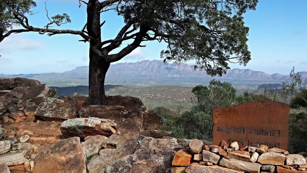
What the Heysen Trail Actually Is
The Heysen Trail is Australia's longest marked walking trail, stretching roughly 1,200 kilometres through South Australia. It begins at Cape Jervis on the southern tip of the Fleurieu Peninsula and ends at Parachilna Gorge in the northern Flinders Ranges, threading through the Adelaide Hills along the way. Named after Hans Heysen, the German-born artist who spent decades painting the eucalypt landscapes of the Adelaide Hills and beyond, the trail was proposed in 1969. Its opening 9 kilometres launched in 1976, and the full route was completed in 1993 after years of work by volunteers, land managers, and the Friends of the Heysen Trail.
This is not a single attraction with an entrance gate. It is a network of marked sections passing through national parks, conservation areas, private farmland, and public reserves. Each section has its own character, its own access logistics, and its own demands on the walker. Understanding that variety is the first step to planning a visit that actually matches what you are looking for.
⚠️ What to skip
Fire season closures apply to many sections of the trail, typically during South Australia's high fire danger period. Check current section status with the SA Department for Environment and Water before any visit, especially between November and April.
The Adelaide Hills Sections: Where Most Visitors Start
For visitors based in Adelaide, the Adelaide Hills sections of the Heysen Trail are the most accessible entry point. The hills begin rising just 20 to 30 minutes' drive east of the city centre, and several trailheads can be reached by car or, in some cases, by bus. The terrain here is characteristically South Australian: dry open woodland, rocky ridge lines, sections of deep gully with stringybark and blue gum, and occasional cleared farmland with long views west toward the plains and the city.
Sections around Waterfall Gully and Morialta are among the most walked, partly because they connect with existing conservation parks that already draw day visitors. The Waterfall Gully area in particular gives a quick feel for the kind of terrain the trail crosses in the southern hills, with shaded creek beds giving way to exposed sandstone ridges. The Morialta Conservation Park sections further east add length and elevation, and are well regarded among local walkers for the quality of the bush and the relative solitude compared to the city's closer green spaces.
Morning light works best in the hills. The gullies are often cool and shadowed even on warm days, and early starters will hear the birds clearly, including rosellas, honeyeaters, and in quieter sections, the mechanical scratching of superb fairywrens in the understorey. By midday in summer the exposed ridges can feel punishing, and the smell of dry eucalypt bark and warm dust becomes the dominant sensory note.
Tickets & tours
Live prices and dates from our booking partner. If you book, we may earn a commission at no extra cost to you.
Ultimate Adelaide and Hahndorf full-day tour
From 94 €Instant confirmationFree cancellationHalf-day Lofty Descents tour by bike
From 89 €Instant confirmationFree cancellationAdelaide kayak tour with expert instructors
From 51 €Instant confirmationFree cancellationTrue Crime Tour in Adelaide
From 21 €Instant confirmationFree cancellation
Walking Seasons and When to Go
The official peak walking season runs from April through October. This aligns with the cooler, wetter months of Adelaide's Mediterranean climate, when temperatures in the hills typically range from around 8 to 22 degrees Celsius. Spring, roughly September to November, brings wildflowers on many sections and longer daylight hours. Autumn, March to May, offers stable mild conditions and less foot traffic than the school holiday periods.
Summer walking, December through February, carries genuine risk on exposed sections. Temperatures in the Adelaide Hills regularly exceed 35 degrees Celsius during heatwaves, and fire danger closes many sections entirely. If you visit during summer and want to walk, stick to very short sections near water, start before 7 am, carry far more water than you think you need, and check fire conditions every morning without exception. This is not a trail that forgives complacency in hot weather.
Winter brings rain and occasional mud, particularly on clay sections of the trail south of Adelaide. Boots with ankle support and waterproofing are worthwhile from June through August. Some creek crossings become genuinely wet after rain, and a few access tracks to remote sections may require a 4WD vehicle in wet conditions. For a broader overview of when conditions are most suitable, see the best time to visit Adelaide guide, which covers the regional climate in more detail.
Getting There and Getting Around
Access varies enormously depending on which section you plan to walk. For the southern end at Cape Jervis, LinkSA operates a daily public bus service from Adelaide and several southern transport hubs, making it possible to reach the trailhead without a car. This is genuinely useful for walkers planning to travel one way and be collected, or to use the ferry to Kangaroo Island before or after walking.
For Adelaide Hills sections, a car is the most practical option for reaching trailheads quickly and flexibly. Some sections near Cleland and Mount Lofty can be combined with a visit to Mount Lofty Summit, which has a car park and is also reachable by public transport from the city. The Friends of the Heysen Trail website maintains transport information and is the most reliable source for current access conditions by section.
💡 Local tip
Download the official trail maps from the Friends of the Heysen Trail website before you go. Mobile coverage is patchy or absent on many sections, and relying on a phone signal for navigation is not safe on longer or more remote walks.
What to Expect on the Trail
The trail is marked with red metal markers, distinctive triangular blazes attached to posts or trees at regular intervals. On well-used sections near the hills, the path is clear and the markers frequent. On remote northern sections through the Flinders Ranges, the trail becomes more rugged, the markers more widely spaced, and the distances between water sources much greater. Long-distance walkers need to plan water carries carefully and consult water availability notes for each section.
Camping along the trail varies by section. Some areas have designated camping spots; others pass through private land or national parks with specific permit requirements. There are no facilities at most campsites beyond a cleared flat area, so self-sufficiency with a tent, cooking equipment, and adequate food is essential for multi-day sections. The trail is not a resort-style trekking route with huts or luggage transfers.
Wildlife encounters are common, particularly in the Adelaide Hills sections. Eastern grey kangaroos are frequently spotted at dusk and dawn near open grassy areas. Echidnas shuffle across the track in the early morning with little concern for walkers. Snakes, including eastern browns, are present and active in warmer months. Stay on the track, watch where you step in long grass, and carry a basic first aid kit. For those interested in the broader natural environment of the hills, the Adelaide wildlife guide provides useful context for what you might encounter.
Photography, Landscape, and What Makes This Trail Distinctive
Hans Heysen painted these landscapes obsessively, and standing on the right ridge at the right time of day, it is easy to understand why. The quality of light in the Adelaide Hills, especially in autumn and early winter, has a particular clarity and warmth. The grey-green of the eucalypt canopy, the ochre bark of older gum trees, the pale grass on south-facing slopes: these are tones that photograph well in the golden hours around dawn and dusk.
For photographers, the ridge sections above the Piccadilly Valley and around the Mount Lofty area offer wide views westward over the Adelaide Plains, with the distant ocean visible on clear days. Early morning visits in autumn and winter frequently produce low mist sitting in the valleys below the ridge line, creating layered landscape images that capture something genuinely characteristic of this part of South Australia.
Those who want a shorter and more panoramic experience without committing to a full trail section might combine a brief walk with a visit to Windy Point Lookout for context on the geography, or explore the Belair National Park sections, which offer well-maintained tracks within a formal park structure. For those who want a multi-day hiking framework, the Adelaide hiking guide covers the range of options across the hills and beyond.
Who Should Think Carefully Before Committing
The Heysen Trail is not the right choice for every visitor. Travellers with limited time in Adelaide who want a quick nature fix will likely find the logistics disproportionate to the experience: getting to the right trailhead, navigating the section, and returning to the city takes planning that a shorter walk in the hills does not require. The trail rewards those who are specifically interested in walking as an activity, not those looking for a scenic backdrop for a few photos before lunch.
Visitors with mobility limitations will find little accommodation here. The terrain is varied and often uneven, with no sections currently identified in official sources as wheelchair accessible. Families with young children can walk shorter sections near the hills, but should choose them carefully based on distance and shade, particularly in warmer months.
Insider Tips
- The Friends of the Heysen Trail publish a series of detailed section notes that go well beyond what any general map app will tell you. Read the relevant notes before each section, not just the trail map. They include current water source reliability, campsites, and known issues with track conditions.
- If you are doing a one-way section walk, consider the transport logistics from the end point before you choose your start. Some sections end at road access points with limited or no public transport, and getting back to Adelaide without a car waiting can be difficult.
- In the Adelaide Hills sections, the walk south from Mount Lofty toward Waterfall Gully is mostly downhill and can be done as a half-day outing from the city with public transport to Mount Lofty and a walk back to a suburb served by buses. Check current trail conditions and fire status before attempting this.
- Fire danger ratings in South Australia are updated daily. On Total Fire Ban days, walking any section is strongly discouraged, and some sections are formally closed. The SA Country Fire Service website provides current ratings by region.
- Light layers matter more than heavy gear on most Adelaide Hills sections. The temperature difference between a shaded gully and an exposed ridge on the same walk can be 10 degrees or more, even in mild weather.
Who Is Heysen Trail For?
- Long-distance and multi-day hikers seeking a serious Australian walking challenge
- Day walkers based in Adelaide who want structured trail options in the hills rather than informal tracks
- Nature photographers drawn to eucalypt woodland landscapes and wide hill-top views
- Travellers who enjoy combining natural and cultural history, given the trail's connection to Hans Heysen's landscape art
- Self-sufficient campers wanting to experience South Australian bush away from road noise and day-tripper crowds
Nearby Attractions
Other things to see while in Adelaide Hills:
- Belair National Park
Proclaimed in 1891, Belair National Park covers 840 hectares of native bushland in the Adelaide Hills, just 11 kilometres from the city centre. It offers walking trails, open grass areas, wildlife watching, and a genuine sense of space without requiring a full-day commitment.
- Carrick Hill
Carrick Hill is a beautifully preserved 1930s Arts and Crafts estate in Springfield, about 8 kilometres from the Adelaide CBD. The property combines a fully furnished house museum, a heritage garden designed to complement the architecture, and a contemporary gallery space — all set within a 100-acre estate in the Adelaide foothills.
- Cleland Wildlife Park
Cleland Wildlife Park sits within a 1,036-hectare national park in the Adelaide Hills, offering one of Australia's most intimate native wildlife experiences. Walk among free-roaming kangaroos, hand-feed wallabies, and get close to koalas — all within 20 minutes of the city centre.
- Gorge Wildlife Park
Set on 14 acres of Adelaide Hills bushland near Cudlee Creek, Gorge Wildlife Park has been introducing visitors to Australian native animals since 1965. It is one of the few places near Adelaide where you can hold a koala, hand-feed kangaroos, and observe over 150 species of Australian and exotic animals, birds, and reptiles in an unhurried, genuinely personal atmosphere.
Planning a trip? Discover personalized activities with the Nomado app.