Cykelslangen (The Bicycle Snake): Copenhagen's Most Elegant Bike Bridge
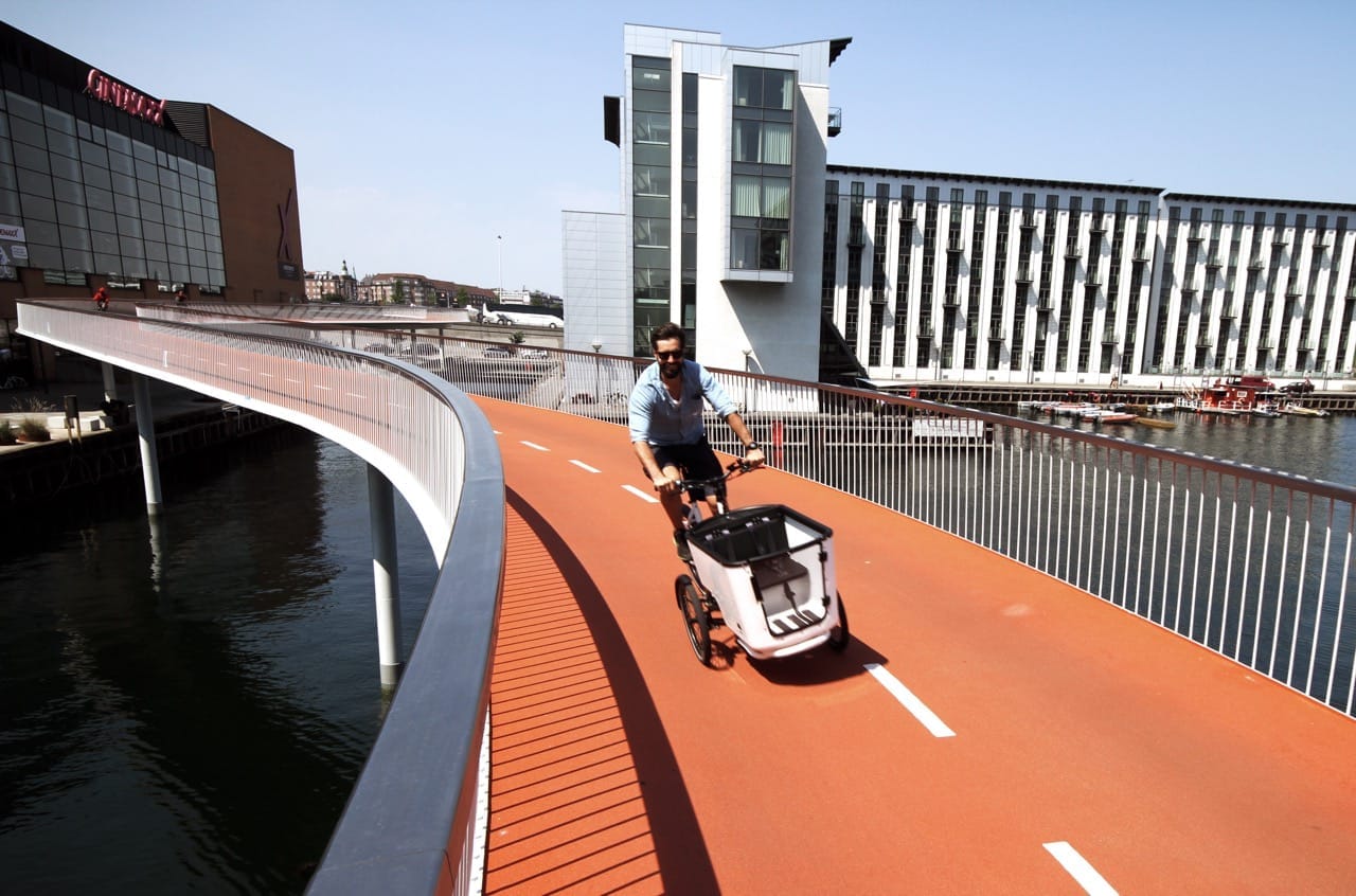
Cykelslangen, or The Bicycle Snake, is an approximately 230-metre elevated cycling bridge in Copenhagen's Vesterbro district. Opened in 2014 and designed by Dissing+Weitling, it curves above the harbor at up to 7 metres height, connecting Fisketorvet and Kalvebod Brygge to Bryggebroen, which leads onward to Islands Brygge. Entry is free, access is 24/7, and the views of the inner harbor are worth the detour.
Quick Facts
- Location
- Kalvebod Brygge / Havneholmen, Vesterbro, Copenhagen (1560 København V)
- Getting There
- Dybbølsbro S-train station (short walk)
- Time Needed
- 15–30 minutes to ride or walk through; longer if you linger for harbor views
- Cost
- Free — no admission, open public infrastructure
- Best for
- Cyclists, architecture fans, harbor views, and anyone tracing Copenhagen's cycling culture
- Official website
- dissingweitling.com/en/project/bicycle-snake
What Cykelslangen Actually Is
Cykelslangen, which translates directly as The Bicycle Snake, is a bike-only elevated bridge spanning approximately 230 metres along the inner harbor waterfront in Vesterbro. It opened in late June 2014 after roughly eight years of planning, designed by the Copenhagen architecture firm Dissing+Weitling in collaboration with engineers Rambøll, contractor MT Højgaard, and landscape architect Marianne Levinsen Landskab, commissioned by the City of Copenhagen.
The bridge starts at the elevated Dybbølsbro road bridge near Fisketorvet shopping mall and sweeps down in a long S-curve to connect with Bryggebroen, the pedestrian and cycle bridge that crosses onward to Islands Brygge on the opposite bank. At its highest point, the deck sits around 5.5 to 7 metres above the quay. The orange-painted steel railing is what most people notice first, visible from several hundred metres away against the grey harbor water.
Its purpose is functional, not decorative: before it existed, cyclists coming from the western side of the city had to share cramped space on the Dybbølsbro road bridge with motor traffic, or take significant detours. Cykelslangen gave them a smooth, uninterrupted descent to the harborfront cycling network — and in doing so, became one of the most photographed pieces of cycle infrastructure in Europe.
ℹ️ Good to know
Cykelslangen is a working commuter route, not a tourist viewing platform. During weekday rush hours (roughly 7:30–9:00am and 4:30–6:30pm), it carries a steady flow of commuter cyclists moving at pace. If you're visiting to photograph or linger, early mornings or weekend afternoons are more comfortable.
The Architecture: Why This Bridge Looks the Way It Does
The design brief had a clear constraint: the bridge had to connect two fixed points at different heights without steep gradients, since laden cargo bikes and elderly cyclists need the same smooth ride as faster commuters. The answer was the S-curve, which allows a gradual descent over a long distance while keeping the structure compact enough to fit within the harbor zone.
Dissing+Weitling chose a simple material palette: weathering steel for the structural frame and the orange-red tubular railing, with a smooth concrete deck. The railing curves continuously from start to finish, which gives the bridge its snake-like quality when viewed from above or from the water. The deck is narrow by road standards — wide enough for two cyclists to pass with care — which keeps the structure light and slender in appearance.
The bridge sits within a broader harbor transformation that has been reshaping Vesterbro and its waterfront since the late 1990s. Fisketorvet mall and the Kalvebod Brygge office buildings mark the edge of what was once industrial port land. Cykelslangen is in many ways the connective tissue between the older city grid and the newer harbor cycling routes heading south to Islands Brygge. For a full picture of how Copenhagen's cycling ambitions are expressed architecturally, the Danish Architecture Center on Bryghuspladsen covers the broader story.
Tickets & tours
Hand-picked options from our booking partner. Prices are indicative; availability and final rates are confirmed when you complete your booking.
1-hour boat harbour tour in Copenhagen
From 26 €Instant confirmationFree cancellationSmall group 3-hour walking tour in Copenhagen
From 45 €Instant confirmationFree cancellationCopenhagen to Malmo one-day tour
From 56 €Instant confirmationFree cancellationFull-day tour to Forest Tower and Forgotten Giants from Copenhagen
From 110 €Instant confirmationFree cancellation
What the Experience Feels Like at Different Times
Early on a weekday morning, the bridge belongs to commuters. The sound is mostly the soft hiss of tires on concrete and the occasional click of gears shifting. Cyclists move in a loose rhythm, most traveling in the same direction. The harbor below reflects pale northern light, and on clear mornings the view west along Kalvebod Brygge takes in a long line of glass office buildings and the water between them.
On summer weekend afternoons, the pace slows considerably. You'll see people stopping partway along to photograph the curve or the harbor view below. The orange railing catches warm afternoon light well, particularly in the hour before sunset, which is when most of the best-known photographs of the bridge are taken. In midsummer Copenhagen, that window stretches until 9pm or later.
At night, the bridge is lit, and the orange railing glows against dark water. Traffic drops, and walking the bridge (though it is technically cycling infrastructure) feels more intimate. The harbor is quiet and the city's ambient noise falls away. Winter visits are possible — the bridge is generally open year-round as part of the public street network — but the deck can become slippery when wet or icy, and the wind off the harbor is sharp in January.
⚠️ What to skip
In wet or icy conditions, the concrete deck can be slippery for cyclists. Copenhagen winters are mild but damp. If you're visiting on a bike in cold months, reduce speed on the curves. For pedestrians walking it, flat-soled shoes with grip are sensible.
Getting There and Getting Around
The nearest S-train station is Dybbølsbro, which sits directly above the western end of the bridge. From the station, the descent to Cykelslangen takes about two minutes on foot or by bike. If you're approaching from central Copenhagen by bike, the route along Vesterbrogade or via the harbourfront path from Rådhuspladsen is straightforward.
The bridge connects seamlessly to the Copenhagen harbor cycling network at its southern end, near Bryggebroen. From there, you can continue south along the water to Islands Brygge and beyond, or cross Bryggebroen east to Christianshavn. The whole loop from central Vesterbro to Islands Brygge and back through the harbourfront takes around 40–60 minutes at a relaxed pace and takes in several of the city's better harbor views. For orientation on cycling routes across the city, the cycling in Copenhagen guide covers rental options and route networks.
If you're coming without a bike and want to walk the bridge, it's manageable but narrow. Pedestrian priority is with cyclists, so staying to one side and being aware of approaching bikes is common courtesy. The ground-level harbor path below runs parallel and is the designated pedestrian route.
Photography: What Works and What Doesn't
The most effective shots of Cykelslangen come from ground level, looking up at the curve of the bridge against the sky. The Fisketorvet end gives you the longest sightline along the S-curve. From the water or from a kayak, the underside of the structure and the reflection in the harbor can produce strong images, but requires either a boat or kayak access to the harbor.
Drone photography over the bridge requires compliance with Danish aviation authority rules and is not something to attempt without advance preparation. From the bridge deck itself, the most interesting shots look straight down the railing toward the curve, with the harbor below. A wide-angle lens handles the geometry better than a telephoto. Golden hour in summer, roughly 8–9pm, gives the orange steel its warmest tone.
Honest Assessment: Is It Worth the Trip?
If you're already cycling the harbor route or heading toward Islands Brygge Harbour Bath, Cykelslangen is directly on your path and takes no additional time. In that context, it's an obvious yes. As a standalone destination requiring a dedicated trip from the city centre, the honest answer is more conditional.
The bridge is genuinely elegant and gives a clear sense of why Copenhagen's cycling infrastructure is studied by urban planners worldwide. Riding it feels different from a standard road crossing: the harbor opens up around you, the surface is smooth, and the curve gives a small sense of motion that a straight bridge wouldn't. For architecture and urban design enthusiasts, it's worth seeing up close.
But visitors expecting a dramatic destination experience may find the bridge itself is over in under two minutes. It rewards context rather than isolated visits. Combining it with a broader Vesterbro afternoon — coffee in the Meatpacking District, a walk along the harborfront, or a swim at Islands Brygge in summer — gives the visit much more weight. Travelers who find cycle infrastructure dull regardless of quality should spend their time elsewhere. There are no cafes, no visitor facilities, and no interpretive signage on the bridge itself.
💡 Local tip
The best single viewpoint for photographing the full length of the bridge is from the Fisketorvet waterfront plaza at the northern end, looking south-southwest along the curve. Arrive before 8am on a summer morning for light, empty bridge, and calm water.
Context: Cykelslangen and Copenhagen's Cycling Ambitions
Cykelslangen didn't emerge in isolation. It's one piece of a sustained, decades-long investment by the City of Copenhagen in cycling as primary urban transport. Copenhagen consistently ranks among the world's most bike-friendly cities, with roughly half of all commute trips made by bicycle within the municipality — a level that places it among the leading large European capitals for cycling. The harbor bridges, of which Bryggebroen and Cykelslangen are the most architecturally notable, were built specifically to remove friction from north-south cycling routes across the water. For travelers interested in exploring these routes systematically, the cycling in Copenhagen guide and the Danish Architecture Center both offer useful framing.
The surrounding Vesterbro district has also changed significantly since Cykelslangen opened. Kalvebod Brygge has continued to develop with new commercial and residential buildings, and the harborfront itself has become a recreational spine connecting the inner city to Amager. Understanding Vesterbro as a district — its older residential character inland versus the newer harbor edge — adds texture to what the bridge represents spatially. The Vesterbro neighborhood guide covers that broader context.
Insider Tips
- The approach from the Dybbølsbro S-train station is the most direct, but walking 10 minutes south along Kalvebod Brygge from Fisketorvet gives you a better sequence: you see the bridge from below and at a distance before riding or walking it, which makes the structure's scale clearer.
- The narrow deck means two cyclists can pass, but three cannot. When photographing from the bridge itself, always stand to the railing side and keep one ear open for approaching bikes from behind.
- On hot summer days, the harbor swimming facilities at Islands Brygge are a 10-minute ride south across Bryggebroen. Combining a bridge crossing with a harbor swim makes for a genuine half-day in the sun.
- If you're visiting specifically for architecture, the view from directly underneath the bridge from the Kalvebod Brygge quay shows the structural logic of the S-curve and the cantilever clearly — and is a better architectural photograph than most shots from the deck.
- The bridge is maintained year-round and is not normally closed for weather, but after severe freezing rain or icy conditions it can be temporarily closed for safety. Check local conditions if visiting in January or February.
Who Is Cykelslangen (The Bicycle Snake) For?
- Cyclists looking for a scenic harbor crossing between Vesterbro and Islands Brygge
- Architecture and urban design enthusiasts studying Copenhagen's cycling infrastructure
- Photographers seeking distinctive harbor-level views with strong graphic geometry
- Travelers building a half-day Vesterbro itinerary combining food, design, and waterfront
- Families cycling the harbor route with children old enough to ride confidently on a narrow elevated deck
Nearby Attractions
Other things to see while in Vesterbro:
- Carlsberg District (Carlsberg Byen)
The Carlsberg District is one of Copenhagen's most ambitious urban transformations: a 160-year-old brewery site in Vesterbro, now evolving into a full neighborhood of converted industrial buildings, new architecture, cultural venues, and independent businesses. Entry to the district is free, and the streets reward unhurried exploration.
- Meatpacking District (Kødbyen)
Once the industrial heart of Copenhagen's meat trade, Kødbyen in Vesterbro has transformed into one of the city's most compelling after-dark destinations. Functionalist white-tiled buildings, protected as national monuments, now house some of the best restaurants and bars in Denmark. Entry to the district is free, and the atmosphere shifts dramatically between day and night.