Zócalo (Plaza de la Constitución): Mexico City's Monumental Heart
At roughly 46,800 square metres, the Plaza de la Constitución is one of the largest public squares in the world. Free to enter at any hour, it anchors the Centro Histórico with the weight of three civilisations: Aztec, colonial Spanish, and modern Mexican.
Quick Facts
- Location
- Plaza de la Constitución S/N, Centro Histórico, Mexico City (CDMX)
- Getting There
- Metro Zócalo/Tenochtitlan (Line 2, blue line) — exit directly onto the square
- Time Needed
- 30 min for the square itself; 2–4 hours if you enter the National Palace or cathedral
- Cost
- Free — no admission fee for the open plaza
- Best for
- History lovers, architecture, national events, sunrise photography
What the Zócalo Is
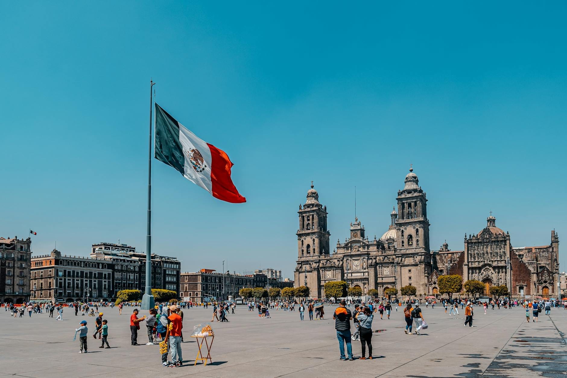
The Plaza de la Constitución, universally called the Zócalo, is the central public square of Mexico City and, by most measures, one of the largest plazas on earth. It measures approximately 195 by 240 metres, covering around 46,800 square metres of flat, stone-paved ground. Standing in the middle of it, you sense that scale physically: the surrounding buildings seem to recede, and the enormous Mexican flag at the centre snaps loudly in the wind that funnels through the space on most afternoons.
The square takes its formal name from the Constitution of Cádiz of 1812, when a commemorative plinth (zócalo in Spanish) was planned for the centre but never completed. The nickname stuck while the monument did not. Today the name Zócalo has spread colloquially to refer to the main square of almost any Mexican city or town, but this original in the capital remains the reference point.
ℹ️ Good to know
The Zócalo sits directly above the ruins of Tenochtitlan, the Aztec capital. The Templo Mayor archaeological zone is visible just northeast of the square, and excavations have been ongoing beneath Centro Histórico for decades.
The Surrounding Buildings: A Crash Course
The square is enclosed on all four sides by structures that span five centuries of power. On the north side, the Metropolitan Cathedral of Mexico City (Catedral Metropolitana) dominates the skyline with its baroque and neoclassical facade. Construction stretched from 1573 to 1813, which explains why the cathedral reads as several architectural periods layered on top of one another rather than a single coherent style.
The entire eastern edge of the plaza is occupied by the National Palace (Palacio Nacional), the seat of federal executive power in Mexico. Inside, Diego Rivera's sweeping murals depicting Mexican history from pre-Hispanic civilisations to the Revolution cover the main staircase and upper corridor walls. Entry to the murals is free and does not require advance booking, though queues form on weekends and national holidays.
The Old City Hall (Antiguo Ayuntamiento) occupies the southern edge. The west side opens onto the commercial street Portal de Mercaderes, a 16th-century arcade that still shelters shops and cafés at street level. The uniformity of the four-sided enclosure gives the Zócalo a sense of deliberate formality that most plazas in Latin America, which tend to have open corners, do not share.
Tickets & tours
Hand-picked options from our booking partner. Prices are indicative; availability and final rates are confirmed when you complete your booking.
Puebla and Cholula guided tour from Mexico City with optional lunch
From 43 €Instant confirmationFree cancellationXochimilco, Coyoacan and Frida Kahlo Museum with skip-the-line tickets
From 63 €Instant confirmationFree cancellationMexico City exploration game and tour in Chimalistac
From 10 €Instant confirmationFree cancellationCuernavaca and Taxco Guided Tour with Optional Lunch
From 40 €Instant confirmationFree cancellation
How the Square Changes Through the Day
Early mornings, roughly between 6 and 8 AM, are markedly different from any other time. The stone is scrubbed clean from the previous day, vendors have not yet set up, and the flag-raising ceremony (which happens at dawn on weekdays) can be watched with almost no crowd. The light at this hour hits the cathedral's west towers at a low angle that photographers chase. The air is cool and noticeably thin at 2,240 metres above sea level — visitors who have just arrived from low-altitude cities often feel the altitude here first.
By mid-morning, organised tour groups arrive, street performers and craft sellers take positions near the cathedral steps, and the smell of corn tortillas and cinnamon from nearby food stalls drifts across the square's edges. This is the most photogenic and energetic period for most visitors: full light, activity, but not yet the density of a weekend afternoon.
Weekend afternoons can feel overwhelming. Large political demonstrations, cultural events, concerts, and seasonal installations (an ice-skating rink appears in winter, a massive Christmas tree in December) regularly close portions of the square or change its character entirely. If you want unobstructed photographs of the open plaza, a weekday morning is significantly better than a Saturday afternoon.
At night, the cathedral and National Palace are lit up and the square takes on a theatrical quality. Families walk, vendors sell balloons and corn on the cob, and the scale of the space becomes almost abstract in the darkness. It is generally considered safe at night given the high police presence, though ordinary street-sense applies in the surrounding blocks.
💡 Local tip
The flag at the centre of the Zócalo is lowered each evening in a formal military ceremony. The exact time shifts with sunset throughout the year. If you are near the square in the late afternoon, check the schedule at the National Palace entrance that day — the ceremony takes about 20 minutes and is worth watching.
Historical Context: Three Layers of Civilisation
The ground beneath the Zócalo was the ceremonial core of Tenochtitlan, the Aztec capital founded in 1325 on an island in Lake Texcoco. The Templo Mayor, the principal religious pyramid of the Aztec empire, stood roughly where the cathedral's apse is now — Spanish colonial builders demolished Aztec structures and used their stones as foundation material, a deliberate act of symbolic and physical erasure.
This layered history is not abstract. Walk one block northeast and you reach the Templo Mayor archaeological zone, where the excavated pyramid foundations are open to visitors. The transition from open colonial plaza to exposed pre-Hispanic stonework within a two-minute walk makes the Centro Histórico unusually legible as a palimpsest of civilisations.
The colonial city that replaced Tenochtitlan was formally established after the Spanish conquest of 1521. The grid of streets that surrounds the Zócalo today largely follows the original colonial urban plan, with a few Aztec causeways still traceable beneath major avenues. The UNESCO World Heritage inscription, which covers the Historic Centre of Mexico City and Xochimilco, recognises both the colonial urban fabric and the underlying pre-Hispanic significance.
Getting There and Moving Around
Metro Line 2 (the blue line) has a station called Zócalo/Tenochtitlan with an exit that opens directly onto the square's eastern side, next to the National Palace. This is the simplest and fastest way to arrive from most of the city. The fare is fixed and inexpensive regardless of distance — verify the current amount on the STC Metro official site before travel, as fares are periodically revised.
The Zócalo is the natural starting point for a walking tour of the Centro Histórico. Calle Madero, the pedestrianised street that runs west from the square, connects the plaza to the Alameda Central within a 10-minute walk. Palacio de Bellas Artes is at the far end of that same route. Most of the major sites in the historic centre are reachable on foot from the plaza.
The neighbourhood immediately surrounding the square is dense with traffic, pedestrians, and informal vendors. Ride-hailing apps (Uber, DiDi, Cabify) operate in the city and can be used for drop-off nearby, but vehicle access immediately around the Zócalo is often restricted, particularly during events. Arriving by Metro is nearly always faster.
⚠️ What to skip
During major political demonstrations, the Zócalo and adjacent streets can be closed or access restricted for hours. Large marches typically proceed along Avenida Juárez toward the square. Check local news if your visit coincides with a politically significant date.
Photography, Practicalities, and What to Bring
For wide-angle shots of the full plaza, position yourself against the wall of the National Palace facing west toward the cathedral in early morning light. The sun rises roughly behind the cathedral from the north, so the facade is in shadow at dawn but catches warm light from around 9 AM onward. The flag at the centre creates a strong vertical element that anchors foreground composition.
Drone photography is not permitted without official government authorisation in the Centro Histórico. Camera tripods are technically allowed on the open plaza but are not permitted inside the National Palace or cathedral. Security guards at both buildings enforce this inconsistently, but be prepared to fold a tripod down.
The altitude affects more people than expect it to. Mexico City sits at 2,240 metres above sea level, and the Zócalo is exposed with no shade. Carry water, apply sunscreen, and pace yourself if you have arrived recently from a low-altitude city. The rainy season runs from roughly May to October, with afternoon thunderstorms that can arrive quickly and drench the open square within minutes. Bring a light rain layer if visiting between June and September.
The plaza surface is flat stone and fully wheelchair-accessible for the open area. The Metropolitan Cathedral and National Palace have internal steps and uneven historic flooring that can be challenging; both have some accessibility provisions but older sections present real obstacles.
Insider Tips
- The flag-raising ceremony at dawn is far less crowded on a weekday than on national holidays or the weekend. The military escort marches out from the National Palace with no fanfare — just show up and stand anywhere near the flagpole.
- The roof terrace of the Gran Hotel Ciudad de México (on the west side of the square, above the Portal de Mercaderes) offers a commanding elevated view of the Zócalo from roughly the second floor level. The art nouveau atrium inside the hotel is worth a look in itself.
- February to April sits in the dry season, offers relatively stable weather with no afternoon storms, and avoids the December holiday crowds. If you are flexible about timing, this window gives the most predictable conditions for exploring the open plaza.
- Pre-Hispanic spiritual ceremonies are occasionally held in the Zócalo, particularly around equinoxes, by groups maintaining or reviving indigenous Mexica traditions. These are public and free to observe. They typically begin at sunrise in the northeast corner of the square.
- The blocks immediately south and east of the Zócalo — particularly around Santo Domingo Square — are quieter than the main plaza and give a better sense of everyday Centro Histórico life without the concentrated tourist density.
Who Is Plaza de la Constitución (Zócalo) For?
- History and archaeology enthusiasts who want to understand the geographic heart of three successive civilisations in one location
- Architecture travellers drawn to the range of colonial and baroque styles visible from a single vantage point
- Early-morning photographers seeking dramatic light, low crowds, and an expansive unobstructed foreground
- Travellers on a tight budget: the plaza, the Diego Rivera murals in the National Palace, and the exterior of the cathedral cost nothing to visit
- First-time visitors to Mexico City who want a spatial and historical anchor before exploring individual neighbourhoods
Nearby Attractions
Other things to see while in Centro Histórico:
- Alameda Central
Founded in 1592, Alameda Central is the oldest public park in the Americas and the green centerpiece of Mexico City's historic center. Flanked by the Palacio de Bellas Artes and a ring of colonial-era institutions, it offers free entry, shaded walkways, and a front-row seat to everyday city life.
- Calle Madero
Avenida Francisco I. Madero connects the Zócalo to the Torre Latinoamericana along one of the oldest streets in the Americas. Free to walk at any hour, it layers colonial architecture, street performance, and everyday city life into a single corridor that doubles as an open-air history lesson.
- Casa de los Azulejos
Casa de los Azulejos is one of the most photographed facades in Mexico City, its exterior wrapped in blue-and-white Talavera tiles from Puebla. With documented origins in the 16th century and operating as a Sanborns restaurant since 1919, it offers free entry and a rare chance to step inside a baroque palace that has survived centuries of history.
- La Ciudadela Artisan Market
The Mercado de Artesanías de La Ciudadela is one of Mexico City's largest and best-known handicraft markets, with more than 350 vendors selling handmade goods from across 22 states. Entry is free, quality ranges from tourist trinkets to serious collector pieces, and knowing how to navigate the stalls makes all the difference.