Stanley Park Seawall: Vancouver's Waterfront Walk Worth Every Step
The Stanley Park Seawall is a free, 9 km paved path circling the edge of one of North America's largest urban parks. With views across Burrard Inlet, English Bay, and the North Shore mountains, it draws walkers, cyclists, and inline skaters year-round — and rewards those who show up early.
Quick Facts
- Location
- Stanley Park, Vancouver, BC V6G 3E2 — northwestern tip of the downtown peninsula
- Getting There
- Bus route 19 serves park entrances; the Coal Harbour waterfront is walkable from downtown
- Time Needed
- 2–3 hours on foot; 1–1.5 hours by bicycle for the full 9 km loop
- Cost
- Free to walk or cycle; bicycle rentals available nearby at additional cost
- Best for
- Scenic walks, cycling, photography, outdoor exercise with mountain and ocean views
- Official website
- vancouver.ca/parks-recreation-culture/stanley-park.aspx
About the Stanley Park Seawall
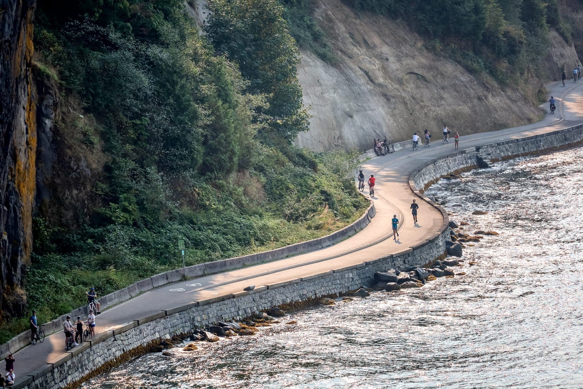
The Stanley Park Seawall is a 9 km paved waterfront path that traces the entire shoreline of Stanley Park, running from Coal Harbour in the northeast, around the rocky western headland, and back down to English Bay in the south. It is the most celebrated section of Vancouver's broader 22–28 km seawall system, which is widely cited as the longest uninterrupted waterfront path in the world.
The path is open year-round, 24 hours a day, with no gates and no admission fee. Pedestrians use the outer (ocean-facing) lane, while cyclists and inline skaters move in a dedicated inner lane in a counterclockwise direction — a convention that keeps traffic flowing and reduces conflict. This separation is well-marked but not always respected on crowded summer afternoons, which is worth knowing before you arrive.
ℹ️ Good to know
The seawall path is directional for cyclists: counterclockwise only. Pedestrians can walk in either direction, but most follow the same counterclockwise flow. Coming in from the Coal Harbour end and heading northwest gives you the water on your left for most of the route.
A Walk Through History: How the Seawall Was Built
The seawall did not appear all at once. Construction of stone retaining walls along Vancouver's waterfront began in 1917, driven by practical necessity: the shoreline of Stanley Park was being steadily eroded by tidal action, and without intervention, the park's western and northern edges would have lost significant ground. The work was slow, largely manual, and carried out in phases over six decades.
The final section encircling Stanley Park was not completed until 1980, meaning the full loop took more than 60 years to finish. Much of the stonework you walk past today is original, and it shows in the rough-cut granite blocks that form the low retaining walls along the more exposed northern stretches. That physical continuity with early 20th-century Vancouver gives the path an unusual quality: it is both a modern recreational route and an artifact of a much older city.
Stanley Park itself occupies the northwestern tip of Vancouver's downtown peninsula, covering roughly 405 hectares of largely forested land bordered by Burrard Inlet, English Bay, and the waters leading out to the Strait of Georgia. For more context on the park's full scope, including interior trails and major attractions within it, see the Stanley Park guide.
The Route: What You See at Each Stretch
Starting from the Coal Harbour end, the first kilometer runs along a calm, marina-lined waterfront with float planes taking off from the water and the North Shore mountains sitting directly ahead across Burrard Inlet. The path here is wide, the surface immaculate, and the views immediate. This opening section is popular with office workers at lunch and early-morning joggers precisely because it delivers a dramatic payoff without any effort.
Past Brockton Point, the path rounds the northeastern corner of the park and the character changes. The forest presses closer to the path, cedars and Douglas firs rising 30 to 40 metres overhead. The smell shifts noticeably here — salt air mixing with the cool, faintly resinous scent of old-growth forest, a combination that is one of the seawall's more surprising sensory details. Freighters anchor in the inlet just offshore, some of them close enough to read the hull markings.
The Brockton Point totem poles stand just inland from the path at this stretch, visible without leaving the seawall. They represent the work of Haida, Kwakwaka'wakw, and other First Nations carvers, and while the current poles are reproductions or replacements of earlier pieces, the grouping is one of the more photographed spots in the city.
The western half of the loop, past Siwash Rock and along the cliffs above English Bay, is the most dramatic section. Waves from the Strait of Georgia hit the rock face directly here during winter storms, and the spray can reach the path. The cliffs drop steeply below the railing, and the view opens up to the south toward the Gulf Islands and Vancouver Island. This is where the seawall feels genuinely remote despite being minutes from one of Canada's largest cities.
The southern stretch winds past Second Beach and back toward the West End neighborhood, with English Bay opening up to the left. On clear evenings, this section frames perfect sunset views across the water toward English Bay Beach, which sits just beyond the park boundary and is worth adding to any seawall itinerary.
Time of Day: How the Experience Changes
Early morning, roughly 6 to 8 am, is when the seawall is at its best. The light comes in low from the east, hitting the water and the North Shore peaks with a clarity that disappears once the day warms up. The path is populated but not crowded: serious cyclists in kit, dog walkers, and dedicated runners who clearly do this every day. The city noise has not yet arrived, and the combination of cool air, birdsong from the forest, and flat water in the harbor is genuinely restorative.
By mid-morning on summer weekends, the seawall becomes one of the most trafficked recreational paths in Canada. Families with strollers, tourists with rental bikes, inline skaters, and organized running groups all share the route simultaneously. The path is wide enough to handle this, but the contemplative quality of the early morning is gone. If your goal is atmosphere over exercise, plan accordingly.
Winter visits, particularly on dry overcast days between November and March, produce a different kind of reward. Foot traffic drops dramatically, the ocean takes on a grey-green intensity, and the forest along the northern stretches looks darker and more imposing. Average January temperatures hover around 4°C, so layering is essential, but the seawall itself is generally clear of snow and ice given Vancouver's mild coastal climate.
💡 Local tip
For photography: the stretch between Prospect Point and Siwash Rock during the golden hour before sunset produces some of the most striking images on the entire route — ocean to the left, old-growth forest to the right, and the light catching the rock faces. A wide-angle lens handles this section well.
Getting There and Practical Logistics
The seawall is accessible from multiple entry points. Most visitors approaching from downtown enter via the Coal Harbour waterfront, which connects directly to the park's northeastern edge without needing transit. From the West End, Denman Street leads directly to the park boundary near English Bay, putting walkers onto the southern end of the loop. TransLink bus route 19 serves the park area, though for most visitors staying anywhere near downtown, the seawall is within comfortable walking distance.
For those who want to cycle the route without their own bike, several rental operators are located near the Denman Street park entrance in the West End. Rentals typically include helmets. Confirm current pricing and availability with operators directly, as rates change seasonally.
The entire 9 km path is paved, flat, and fully accessible for wheelchair users and strollers. There are no significant elevation changes on the seawall itself, though some interior park connections involve stairs or grades. Restroom facilities exist at Lumbermen's Arch, Second Beach, and near Brockton Point. During peak summer months, these fill up; plan accordingly or use facilities at the park pavilions slightly inland.
⚠️ What to skip
Vehicle parking inside Stanley Park is paid and fills completely by mid-morning on summer weekends. If driving, arrive before 9 am or approach via transit or on foot from downtown. Park Drive, the one-way road through the park, often backs up with cars circling for spaces during busy periods.
Connecting the Seawall to the Rest of Vancouver
The Stanley Park Seawall does not exist in isolation. It connects directly to the broader Vancouver Seawall, which continues southeast along Coal Harbour toward Canada Place, through Yaletown, and onward to the Yaletown seawall section and beyond. A dedicated guide to the full route is available in the Vancouver Seawall guide, which covers the entire 28 km system.
Within Stanley Park itself, the seawall is only one layer of what's available. Interior trails connect through old-growth forest to landmarks including Lost Lagoon, the Rose Garden, and Prospect Point, the promontory directly below Lions Gate Bridge that offers some of the highest views in the park. None of these require leaving the park or paying any fee.
Visitors combining the seawall with a broader day in the area should note that Prospect Point sits at the northernmost tip of the park, accessible either by the seawall path or by Park Drive, and gives a different perspective on the same coastline from roughly 60 metres above the water.
Who Should Temper Their Expectations
The seawall earns its reputation, but it is worth being clear about what it is not. It is a flat, paved urban recreation path, not a wilderness experience. The forest alongside the northern section is impressive, but the path never goes into it. Those seeking technical trails, elevation gain, or genuine solitude should look at the interior park trails or consider options across the inlet on the North Shore.
On peak summer weekends, the seawall between Denman Street and Brockton Point can feel more like a moving crowd than a nature walk. The experience degrades significantly in these conditions if you are easily frustrated by foot traffic. Arriving before 8 am or visiting on a weekday largely solves this problem.
Visitors with limited mobility who want to see the full loop should note that while the path is flat and paved, 9 km is still 9 km. Cycling or renting a mobility device for part of the route is a practical option. There is no shuttle service operating on the seawall path itself.
Insider Tips
- Start the loop from the Coal Harbour end rather than Denman Street. The Coal Harbour approach gives you the mountains ahead of you immediately and builds toward the more dramatic western cliffs — a better narrative arc for a first visit.
- The bench cluster just past Siwash Rock, facing southwest, is one of the least-visited viewpoints on the entire loop despite being among the most visually striking. Most cyclists pass without stopping; most walkers are too tired by this point to notice. Stop here.
- Bring a light rain layer regardless of the forecast. The western headland section is fully exposed to weather coming off the strait, and conditions there can differ noticeably from what it feels like at the Coal Harbour entrance just 4 km away.
- The seawall connects to the Coal Harbour waterfront path, which in turn reaches Canada Place. Walking from the start of the Stanley Park loop all the way to Canada Place adds only about 1.5 km and takes you through some of the most architecturally interesting waterfront in downtown Vancouver.
- Cyclist rental operations near Denman Street often offer tandem bikes, which are slower but make the loop accessible for mixed-ability groups. Book ahead on summer weekends — they sell out by mid-morning.
Who Is Stanley Park Seawall For?
- Walkers and joggers wanting a long, flat route with continuous ocean and mountain views
- Cyclists looking for a scenic, car-free loop accessible directly from downtown accommodation
- Families with strollers or young children needing a fully accessible, free outdoor activity
- Photographers targeting golden-hour coastal light with forest and ocean in the same frame
- Visitors with only a half-day in Vancouver who want a single route that captures the city's geography
Nearby Attractions
Other things to see while in West End:
- Brockton Point Totem Poles
The Brockton Point Totem Poles are an outdoor collection of nine First Nations poles carved by artists from the Squamish, Kwakwaka'wakw, Haida, Nisga'a, and Nuxalk Nations. Set in a meadow at the edge of Burrard Inlet inside Stanley Park, the site is free, open around the clock, and reachable on foot from Coal Harbour in about 20 minutes.
- Davie Village
Davie Village is the cultural and social centre of Vancouver's queer community, stretching along Davie Street between Burrard and Jervis in the West End. Free to explore at any hour, it offers a mix of LGBTQ+ history, independent cafés and bars, the iconic rainbow crosswalk at Davie and Bute, and Jim Deva Plaza, a public gathering space that doubles as a community memorial.
- English Bay Beach
English Bay Beach, also known as First Beach, has served as Vancouver's primary urban beach for over a century. Stretching along Beach Avenue in the West End, it offers free access to a sandy shoreline with mountain backdrops, reliable sunsets, and a lively summer atmosphere that fades into quiet morning solitude the rest of the year.
- Lost Lagoon
Lost Lagoon is a 16.6-hectare freshwater lake sitting at the gateway to Stanley Park in Vancouver's West End. Free to visit at any hour, it draws birdwatchers, joggers, and anyone needing a few minutes of calm at the edge of a major city. The 1.75 km perimeter trail is one of the more underrated walks in Vancouver.