Yaletown Seawall & False Creek: Vancouver's Waterfront Walk
The False Creek Seawall through Yaletown is one of Vancouver's most rewarding waterfront walks, tracing the north shore of False Creek past converted warehouses, pocket parks, and bobbing sailboats. It's free, flat, and accessible year-round, making it a reliable choice whether you have an hour or an entire afternoon.
Quick Facts
- Location
- False Creek north shore, Yaletown, Vancouver BC — between Burrard Street Bridge and Science World
- Getting There
- Yaletown–Roundhouse Station (Canada Line SkyTrain) or Main Street–Science World Station
- Time Needed
- 45–90 minutes for a one-way walk; 2–3 hours if you stop at parks and cafés
- Cost
- Free (open public path)
- Best for
- Morning joggers, leisure cyclists, waterfront picnics, architectural photography
- Official website
- stanleyparkvan.com/stanley-park-van-seawall-false-creek.html
About the Yaletown Seawall
The False Creek Seawall through Yaletown is a paved, mostly flat waterfront path that follows the north shore of False Creek from the Burrard Street Bridge in the west to the plaza in front of Science World in the east. The full False Creek Seawall circuit is approximately 10 km and is commonly described as taking about 60 to 90 minutes to walk end to end at a relaxed pace. The Yaletown section is a manageable portion of that, and the one most visitors naturally gravitate toward because of the neighbourhood behind it.
The path is separated into parallel lanes, one for pedestrians and one for cyclists, for most of its length. A few short transition zones are shared, so paying attention near busy intersections matters, but overall the layout is intuitive. The surface is paved concrete and generally in good condition, making it accessible for strollers, wheelchairs, and mobility aids. Public washrooms are available at David Lam Park and inside the Roundhouse Community Centre, both easy to locate along the route.
ℹ️ Good to know
The seawall is open 24 hours a day, year-round, with no admission fee. That said, lighting along the path is limited after dark, and most visitors stick to daylight hours.
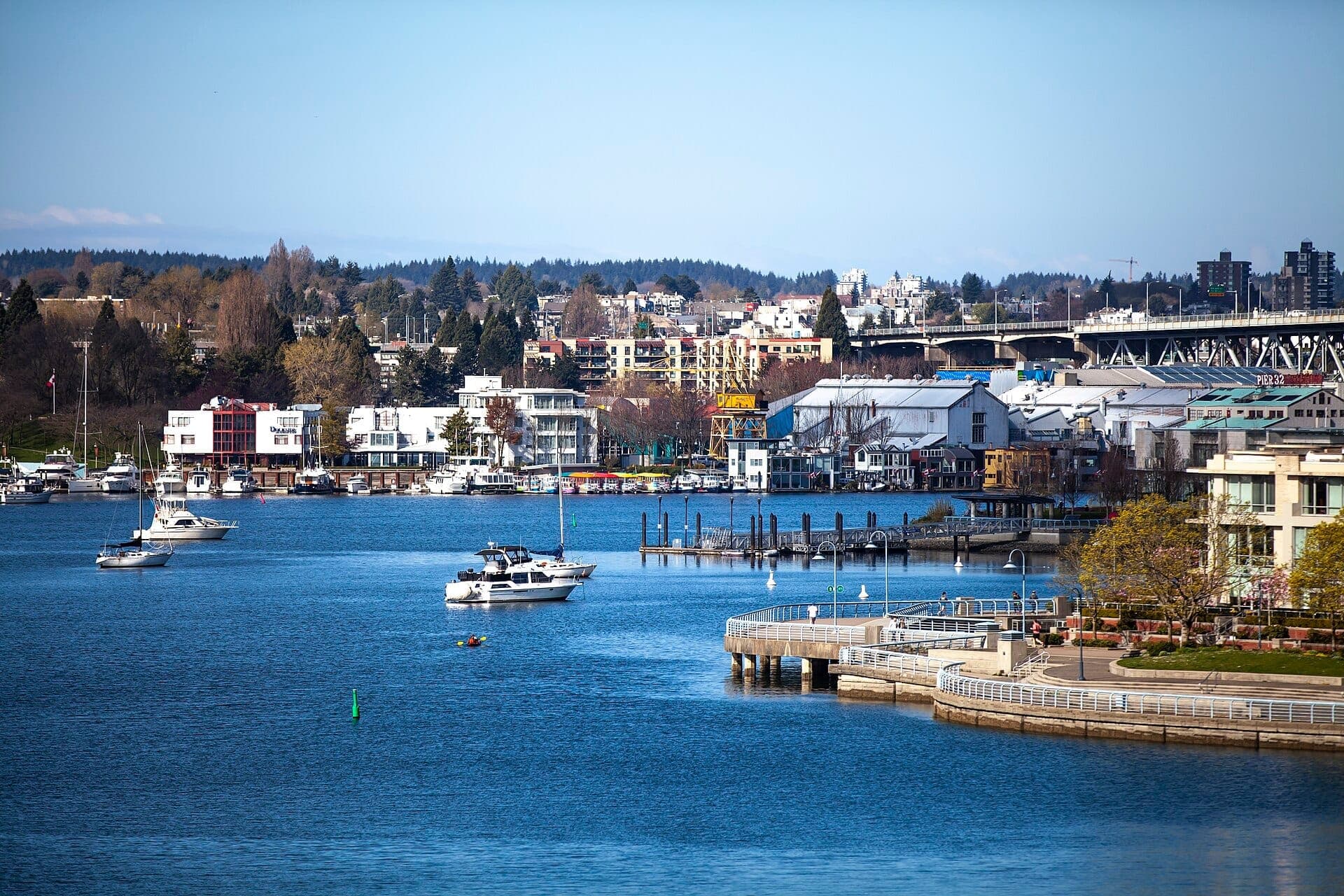
The View Across False Creek
From the Yaletown seawall, you look south across False Creek toward Granville Island and the Mount Pleasant and Fairview slopes rising behind it. The water is a working marina as much as a scenic feature: small ferries cross constantly, kayaks slide past, and sailboat masts shift with the tide. The Burrard Street Bridge anchors the western end of the view, its green concrete spans rising in that distinctly 1930s civic style.
On a clear morning, the reflection of the Granville Bridge on the water and the North Shore mountains in the background produces the kind of framing that makes Vancouver's waterfront reputation make sense. But this view is weather-dependent. In winter, overcast skies flatten the light significantly, and the mountains disappear entirely in low cloud. If mountain backdrops matter to you, check the forecast the night before. For dedicated viewpoint seekers, the best views in Vancouver guide covers spots where clear-day panoramas are more reliably spectacular.
The False Creek ferries are a functional part of the route rather than just a tourist feature. Small passenger boats operated by two competing companies cross False Creek at several docking points along the seawall, connecting Yaletown to Granville Island and other points around the creek for a few dollars per ride. Catching one is an easy way to turn a one-way walk into a loop. See the False Creek Ferries page for current fares and schedules.
How the Walk Changes by Time of Day
Early mornings between 6:30 and 9:00 bring a noticeably different crowd than afternoons. Joggers run in steady streams, dog walkers cluster near the grass at David Lam Park, and the coffee shops on the Yaletown side are just opening. The water is calm before the ferry traffic picks up, and the light, particularly in summer, falls low and golden across the inlet. This is the quietest, most atmospheric window for photography.
Midday on weekends is the busiest period, especially between May and September. Cyclists moving at pace share the path with slow-moving families, and the ferry docks at the Yaletown Roundhouse get queues. It's perfectly manageable, but the contemplative quality disappears. Weekday afternoons are a reasonable middle ground: fewer recreational cyclists, more people on lunch breaks, and the restaurants along the Yaletown edge start filling up.
Sunset draws another crowd entirely. The seawall faces generally south and southwest in places, meaning the sky above Granville Island lights up with color on clear evenings while the lights of the apartment towers on both shores begin reflecting on the water. Summer sunsets in Vancouver occur late, often after 9:00 PM in June and July, so this is a practical option even after dinner.
Yaletown's Industrial Past and What Replaced It
The Yaletown waterfront was industrial rail-yard territory through much of the late 19th and 20th centuries. The neighbourhood's name traces back to workers who relocated from Yale, BC when the Canadian Pacific Railway moved its maintenance operations here in the 1880s. The low-rise brick warehouse buildings that line the streets behind the seawall, now converted into restaurants and boutiques, are the surviving physical record of that era.
Expo 86, Vancouver's world exposition, was the catalyst for the waterfront's transformation. The exposition was held on the north shore of False Creek, and the infrastructure built for it, including the original seawall sections and the Roundhouse building (then used as a locomotive turntable facility), became the foundation for the residential and mixed-use redevelopment that followed through the 1990s and 2000s. Yaletown today is one of Vancouver's denser inner-city neighbourhoods, shaped almost entirely by that post-Expo conversion.
The Roundhouse Community Centre, which sits at the corner of Davie and Pacific near the Yaletown–Roundhouse SkyTrain station, still contains the original CPR locomotive No. 374, the engine that pulled the first passenger train into Vancouver in 1887. It's visible through glass in a dedicated pavilion at no charge, and it's worth a two-minute detour if history interests you.
David Lam Park and the Seawall's Green Anchors
David Lam Park is the largest green space directly on the Yaletown seawall. It stretches along the waterfront with open lawn, mature trees, a children's water play area (seasonal), and benches facing the water. On warm afternoons it fills with people reading, picnicking, or watching the seaplane traffic over False Creek. The park also serves as a de facto gathering space during public events, including the city's fireworks competitions in summer.
The combination of the park's open grass and the paved seawall just below it makes this stretch genuinely pleasant for an extended stop rather than a pass-through. If you're walking with children, the transition between the path and the park lawn is easy and safe. There are water fountains at the park during warmer months, though bringing your own water bottle is always sensible.
💡 Local tip
The Yaletown–Roundhouse Canada Line station puts you on the seawall within a 5-minute walk. Take the Davie Street exit and walk south toward the water. You'll reach the path before you need to consult a map.
Cycling the Seawall: What to Know
The False Creek Seawall is one of Vancouver's most popular cycling corridors, and several bike rental and bike-share options exist nearby. Mobi by Shaw Go, Vancouver's public bike-share system, has docking stations in Yaletown and along the seawall route. Rental bikes are also available from operators near Granville Island and elsewhere in the area.
Cycling direction on the seawall is generally one-way in certain sections, with counterclockwise being the convention for the False Creek loop. Signs and painted markings indicate the correct flow. Cyclists should keep speed low near pedestrian-heavy areas, particularly around ferry docks and park entrances. For a longer cycling route that connects to the Yaletown seawall, the Vancouver Seawall guide covers the full waterfront network, including how the False Creek section links to the Stanley Park and Coal Harbour stretches.
What to Eat and Do Along the Route
Yaletown's restaurant strip runs along Mainland Street and Hamilton Street, one block back from the seawall. The converted loading docks of former warehouses now function as patio seating, and the brick exteriors give the area a visual consistency that most of Vancouver's newer developments lack. Brunch spots, coffee roasters, and upmarket casual dining are the dominant formats. Prices reflect the neighbourhood's positioning as one of Vancouver's more expensive inner-city areas.
If you want to continue into a broader exploration of the area after the walk, the seawall connects naturally to the rest of False Creek. Heading west from David Lam Park leads toward the Burrard Bridge and eventually Vanier Park and Kitsilano. Heading east brings you past the Plaza of Nations and Science World, whose distinctive geodesic dome is visible from the path well before you reach it.
Insider Tips
- The best unobstructed view of the North Shore mountains from this stretch of seawall is from the western end of David Lam Park, facing roughly northwest. Position yourself here on a clear morning for the cleanest sightline.
- The two False Creek ferry companies (Aquabus and False Creek Ferries) operate independently and stop at slightly different docks. If you plan to cross to Granville Island, check which dock is closest to where you're standing before walking past it.
- Mobi bike-share docking stations near Yaletown–Roundhouse Station are often full by mid-morning on weekends. If you're planning to cycle the seawall, pick up a bike before 9:00 AM or check the app for dock availability before walking to a station.
- CPR Locomotive No. 374 inside the Roundhouse Community Centre is a genuinely interesting stop for five minutes and costs nothing. The pavilion faces Pacific Boulevard and is easy to spot from the street.
- The seawall between the Plaza of Nations and Science World is notably quieter than the Yaletown stretch on weekends. If you want a calmer walk, start from the Main Street–Science World SkyTrain station and head west.
Who Is Yaletown Seawall & False Creek For?
- Morning joggers and cyclists looking for a flat, safe waterfront route with good sight lines
- Visitors who want to understand Yaletown's post-industrial character while getting some fresh air
- Families with strollers or young children who need a flat, paved, car-free route with nearby park space
- Architecture and photography enthusiasts interested in Vancouver's Expo 86 legacy and warehouse conversions
- Travelers who want to connect the seawall walk to a Granville Island visit via the False Creek ferries
Nearby Attractions
Other things to see while in Yaletown:
- False Creek Ferries
False Creek Ferries has been shuttling locals and visitors across Vancouver's inner waterway since 1982. With 9 stops linking Yaletown, Granville Island, Kitsilano, and beyond, these small blue vessels are both a practical commuter tool and one of the most pleasant ways to see False Creek from the water.