PATH Underground City: Navigating Toronto's 30 km Underground Network
The PATH is Toronto's downtown pedestrian walkway system stretching more than 30 km beneath the Financial District. Free to enter and open around the clock, it connects Union Station, major office towers, shopping centres, and six TTC subway stations — making it both a practical commuter route and a genuinely impressive piece of urban infrastructure.
Quick Facts
- Location
- Downtown Toronto, below the Financial District; main entry at Union Station, 65 Front St W
- Getting There
- TTC Line 1: Union, King, Queen, Osgoode, St. Andrew, and Dundas stations all connect directly
- Time Needed
- 20 minutes (point-to-point commute) to 2+ hours (exploration or shopping)
- Cost
- Free to enter; individual shops, restaurants, and services charge their own prices
- Best for
- Winter commuters, rainy-day exploration, shoppers, transit connectors
What Exactly Is the PATH?
The PATH Underground City is the world's largest underground pedestrian network, recognized by Guinness World Records, and it sits beneath one of North America's most densely developed financial districts. Officially called PATH — Toronto's Downtown Pedestrian Walkway — the system spans more than 30 km of climate-controlled corridors and includes more than 1,200 shops and services., ranging from pharmacy chains and fast-food outlets to independent cafés and specialty clothing stores.
The network links Union Station and its GO Transit and UP Express connections in the south to the Eaton Centre shopping mall and the area around Nathan Phillips Square in the north. East to west, it threads through Scotia Plaza, First Canadian Place, Royal Bank Plaza, and dozens of other office towers. Six TTC subway stations connect directly into the system: Union, King, Queen, Osgoode, St. Andrew, and Dundas.
Visitors usually discover the PATH as a transit shortcut or shelter from a January snowstorm. But understanding it as infrastructure rather than tourist attraction matters here: this is primarily a working commuter environment used by hundreds of thousands of office workers daily. That said, for anyone spending time in downtown Toronto, learning to navigate even a basic section of the PATH opens up practical connections that aren't obvious from street level.
A Brief History of the Network
The origin of Toronto's underground network traces to 1900, when Eaton's department store built a tunnel connecting its main Yonge and Queen Street building with its annex across James Street. That original tunnel still forms part of the PATH today, running beneath the area now occupied by the Toronto Eaton Centre.
For several decades the system grew without a formal plan — each office tower or mall added its own concourse, often in a slightly different direction than its neighbours. The result is a network that feels organic rather than designed. Corridors change width, ceiling height, and architectural finish as they pass from one building's management to the next. This patchwork character is precisely what makes navigation confusing for newcomers and what gives the PATH its particular underground texture.
Significant expansion happened through the 1970s and 1980s, as Toronto's Financial District grew rapidly. City planners eventually began to coordinate signage and mapping standards, though the network remains owned and operated section-by-section by the buildings it passes through, rather than by a single authority. The City of Toronto maintains wayfinding standards and official maps, but building owners control access points, which is why some entrances close at night or on weekends.
Tickets & tours
Hand-picked options from our booking partner. Prices are indicative; availability and final rates are confirmed when you complete your booking.
Toronto Old Town: Dark Side Exploration Game and Tour
From 12 €Instant confirmationFree cancellationLEGOLAND Discovery Centre Toronto tickets
From 16 €Instant confirmationFree cancellationToronto 'Little Canada' entrance tickets
From 27 €Instant confirmationFree cancellationNiagara Falls evening tour with boat, dinner and Illumination Tower
From 77 €Instant confirmationFree cancellation
What It Actually Feels Like Down There
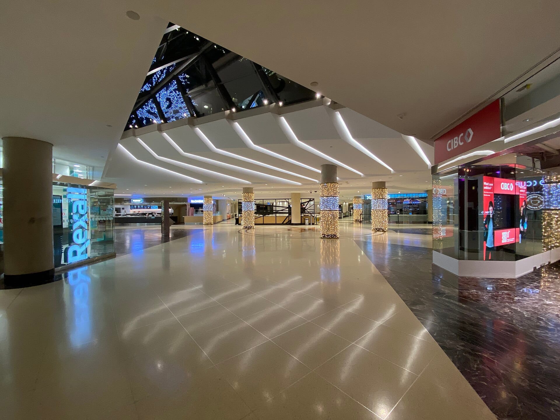
The dominant sensory experience of the PATH is fluorescent light, temperature control, and the low hum of ventilation systems. On a weekday morning between 7:30 and 9:30 AM, the main arteries around Union Station and First Canadian Place carry dense foot traffic: office workers moving fast, coffee in hand, earbuds in. The smell shifts from fresh pastry near bakery counters to cleaning product near elevator banks. The floors are mostly hard polished stone or sealed concrete, and the sound of footsteps accumulates quickly in the wider passages.
By midday the pace changes. Lineups form at lunch counters in the food courts near TD Centre and Scotia Plaza. The corridors between towers fill with people browsing window displays or taking longer routes to avoid going outside. This is the most active the PATH gets for retail: the lunch hour is when most of the shops do their real business.
After 6 PM on weekdays, the atmosphere shifts considerably. Office workers clear out fast, and entire sections go quiet in a way that can feel slightly disorienting if you're expecting a populated environment. By 8 PM, many shops are closed, some corridor sections see very light foot traffic, and the experience is more industrial corridor than urban mall. On weekends, the same applies to most of the Financial District sections, while areas near the Eaton Centre remain more active.
⚠️ What to skip
Many PATH access points and building entrances close in the evenings and on weekends, and while much of the network is technically open 24 hours, practical access is limited by individual building hours. If you're navigating after business hours, plan for potential dead ends and have a street-level backup route.
Practical Navigation: How to Get Around Without Getting Lost
Getting lost in the PATH is genuinely easy, and acknowledging that upfront is more useful than false reassurance. The network was built incrementally by different developers, and corridors frequently change direction, go up or down half-levels, or switch from one building's wayfinding system to another's. Colour-coded signs using the cardinal directions (red for south, blue for north, yellow for east, orange for west) are posted throughout, and they help once you internalize the system, but the first hour underground can be disorienting.
The most practical approach for a first visit is to anchor to known landmarks: Union Station in the south, the Eaton Centre in the north, and the TD Centre or Scotia Plaza in the middle. Pick one corridor and follow it consistently rather than taking every branch. The City of Toronto provides official PDF maps on its website, and the Mappedin digital platform offers an interactive version that is substantially easier to read in real time.
💡 Local tip
Download the PATH map before you go underground — cell signal is unreliable in large sections of the network. The City of Toronto's official map and Mappedin's interactive version are both available online.
Accessibility varies across the network. Many buildings have elevators and step-free concourse sections, but the PATH is not uniformly accessible throughout. Certain connections involve stairs without an adjacent elevator, and the routes between buildings sometimes require going up to street level and re-entering elsewhere. Travellers with mobility needs should consult the City of Toronto's accessibility information and plan specific routes in advance rather than improvising.
If you're entering from public transit, Union Station is the most logical starting point for most visitors. The station connects TTC subway lines, GO Transit regional trains, and the UP Express airport link, and the PATH connections are clearly signposted from the main concourse. For more on the station itself, see the Union Station guide.
Shopping, Eating, and Services in the PATH
The commercial offering inside the PATH is broader than most visitors expect, though the emphasis is firmly on convenience rather than boutique discovery. You'll find pharmacies, banks, dry cleaners, opticians, and mobile phone repair shops alongside the expected chains: fast-food restaurants, coffee brands, bakeries, and casual clothing retailers. Food courts are the primary lunch destination for thousands of office workers daily, and quality ranges from adequate to surprisingly good depending on the vendor.
For destination shopping, the PATH's most significant node is the Toronto Eaton Centre, which the network connects to directly from the south. The Eaton Centre brings a more conventional mall experience into the PATH system, with anchor department stores and a much wider range of retail tenants than the Financial District corridors offer.
Dining options skew heavily toward lunch-only or all-day casual: expect food court counters, grab-and-go delis, and fast casual chains as the dominant formats. Sit-down restaurants do exist within PATH-connected buildings, but they're typically accessed by taking an elevator up to lobby or higher floors rather than sitting directly on the underground corridor level. Anyone looking for a serious meal should expect to emerge back to street level.
When the PATH Is Most Useful (and When to Skip It)
The PATH is most genuinely useful to visitors during winter, when downtown Toronto's temperatures can drop below -10°C and wind chill makes street-level walking actively unpleasant. The ability to walk from Union Station to the Eaton Centre, or from a hotel connected to the network to a meeting or museum, without putting on a coat, is the system's real value proposition. During a cold snap in February, the PATH corridors are warm, crowded, and efficient in a way that makes the confusion of navigation worthwhile.
In summer, the calculation changes. Toronto's summer temperatures are warm but rarely extreme, and the street-level experience of the Financial District and surrounding neighbourhoods is far more engaging than the underground corridors. The waterfront, nearby parks, and the streetscape around St. Lawrence Market offer much more visual interest than anything the PATH provides. Using the PATH in July because it's underground is reasonable if you need a specific connection; going underground specifically as an experience is a poor trade-off when the street is better.
Rainy days at any time of year are another strong use case. The PATH offers a dry route between major transit hubs and shopping destinations, and it handles heavy rain days better than an umbrella does. Business travellers staying in hotels connected to the network, particularly those along Front Street and in the core Financial District, will find it a straightforward way to reach meetings, restaurants, and transit without touching the outdoors at all.
ℹ️ Good to know
The PATH connects to several major downtown hotels, including those along Front Street and Bay Street. If you're choosing accommodation in downtown Toronto and want underground access, check whether your hotel has a direct or near-direct PATH connection before booking.
Travellers who find underground spaces claustrophobic, or who are primarily visiting Toronto for its outdoor character and neighbourhood culture, will get little from the PATH. The system has almost no natural light, no greenery, and no architectural drama. If your Toronto itinerary is built around neighbourhoods like Kensington Market, Queen West, or the Distillery District, the PATH is simply not relevant to your plans. For those visitors, a better use of limited time is above ground. See the Toronto walking tours guide for street-level exploration options.
Insider Tips
- The PATH official wayfinding system uses four colours corresponding to compass directions: red (south), blue (north), yellow (east), and orange (west). Memorising this colour code for even five minutes before entering will save significant backtracking.
- The least crowded time to explore without fighting lunch traffic is between 2 PM and 4 PM on weekdays. You'll have clear sightlines and can actually look at the space rather than navigating around people.
- Royal Bank Plaza, accessible from the PATH near Union Station, has an interior atrium worth looking up at: its towers use gold-tinted glass that casts a warm light into the lower concourse levels, one of the few visually interesting architectural moments in the network.
- If you get disoriented, the fastest reorientation strategy is to find an elevator, go up to the building lobby level, identify the street address from the lobby directory, and re-enter the PATH with your bearings reset.
- Brookfield Place, connected to the PATH near Bay and Front, has a cathedral-like Allen Lambert Galleria atrium at its heart — a genuinely spectacular piece of architecture that most PATH users rush through without looking up. The steel-and-glass vaulted ceiling is worth two minutes of your time.
Who Is PATH Underground City For?
- Winter visitors wanting to move between Union Station, hotels, and the Eaton Centre without exposure to sub-zero temperatures
- Business travellers with meetings across the Financial District who want efficient, weather-independent routes between buildings
- Rainy-day shoppers who want to reach major retail destinations from transit hubs without getting wet
- Transit users arriving at Union Station who need to reach specific downtown addresses without navigating street-level intersections
- Urban infrastructure enthusiasts with a genuine interest in how cities manage pedestrian movement at scale
Nearby Attractions
Other things to see while in Downtown Toronto:
- Allan Gardens Conservatory
Allan Gardens Conservatory is a free, year-round botanical conservatory at 160 Gerrard Street East in downtown Toronto. Housed in six glass display houses anchored by a 1910 Edwardian Palm House, it holds about 1,500 m² of tropical palms, cacti, orchids, and seasonal blooms. One of the oldest parks in Toronto, it remains one of the city's most underrated green spaces.
- Art Gallery of Ontario
The Art Gallery of Ontario is one of North America's largest art museums, housing over 90,000 works inside a landmark Frank Gehry-renovated building in downtown Toronto. From Indigenous Canadian art to European masters and contemporary photography, the AGO rewards focused visitors and casual explorers alike.
- Brookfield Place (Allen Lambert Galleria)
The Allen Lambert Galleria inside Brookfield Place is a free, publicly accessible arcade designed by architect Santiago Calatrava between 1987 and 1992. Its arching steel-and-glass canopy, rising between two of downtown Toronto's tallest towers, is one of the most impressive interior spaces in Canada.
- Campbell House Museum
Built in 1822 for Upper Canada's Chief Justice, Campbell House Museum is the oldest surviving residence from the original Town of York. Moved to its current downtown corner in 1972 and opened as a museum in 1974, it offers an intimate, unhurried window into early colonial Toronto — a sharp contrast to the glass towers surrounding it.