Kamo River (Kamogawa): Kyoto's Living, Breathing Riverfront
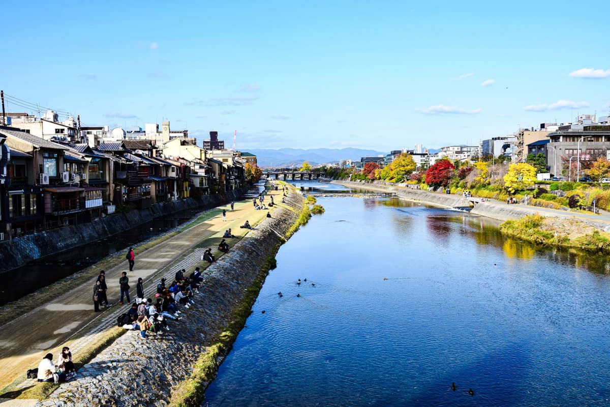
The Kamo River runs north to south through central Kyoto, serving as the city's most democratic public space. Free to access at any hour, the riverbanks draw joggers at dawn, couples at dusk, and everyone in between. This is not a ticketed sight — it is the living backdrop of Kyoto daily life.
Quick Facts
- Location
- Central Kyoto, running through Downtown Kyoto (Nakagyō-ku and Shimogyō-ku); popular section between Shijo and Demachiyanagi
- Getting There
- Gion-Shijo Station (Keihan Main Line) and Kyoto-kawaramachi Station (Hankyu Kyoto Line) for the central Shijo Bridge area; Demachiyanagi Station (Keihan Ōtō Line / Eizan Line) for the northern delta section
- Time Needed
- 30 minutes for a short stroll; 2–3 hours for a full walk from Shijo Bridge to Demachiyanagi
- Cost
- Free — the riverside paths are public space, open 24 hours with no admission
- Best for
- Slow walkers, couples, solo travellers wanting a break from temples, early risers, and anyone curious about everyday Kyoto
- Official website
- www.japan.travel/en/spot/1183
What the Kamo River Actually Is
The Kamo River (鴨川, Kamo-gawa, literally 'Duck River') is a roughly 30-kilometre waterway flowing south through the heart of Kyoto City before joining the Katsura River in Fushimi, becoming part of the Yodo River system. Unlike the curated heritage sites that define most visitor itineraries here, the Kamogawa is open space — no entrance gate, no queue, no closing time. It is the place where Kyoto residents actually live their leisure hours.
The most visited section runs from Shijo Bridge north to the triangular delta at Demachiyanagi, where the Takano River merges with the Kamo. This stretch covers the liveliest urban riverfront and includes the famous summer riverside dining decks (known as 'yuka'), several key bridges, and the long gravel-and-grass banks where locals sit in equidistant pairs with almost mathematical precision — a phenomenon Kyoto residents acknowledge with dry humour.
ℹ️ Good to know
Under Japan's River Act, the waterway is officially designated 'Kamo River' throughout its length. In casual speech, Kyotoites generally call it 'Kamo-gawa' without a formal distinction between sections, so for visitors the naming nuance matters little — it all refers to the same beloved river.
How the River Changes Through the Day
Early morning, roughly 6 to 8 a.m., belongs to the locals. Joggers in reflective gear move along the paved paths on both banks. Older residents practice tai chi on flat sections of stone near the water. Grey herons stand motionless in the shallows, indifferent to everyone. The light at this hour is low and cool, hitting the water at an angle that turns the surface silver. The air smells faintly of river silt and morning moisture — not unpleasant, more like the underside of a clean stone.
By mid-morning, the banks start to fill with a more mixed crowd: school groups crossing bridges, delivery cyclists using riverside paths as cut-throughs, the first tourists arriving with cameras. Near the Kamogawa Delta around Demachiyanagi, the stone stepping-stones crossing the river become a minor attraction in themselves, particularly for children who turn the crossing into a competition. These flat, turtle-shaped stones are low enough to feel precarious in a satisfying way, and the crossing usually draws a small audience from the bank.
Afternoons in summer are the one time the riverbank is less pleasant than its reputation suggests. Kyoto sits in a basin surrounded by mountains on three sides, and afternoon heat can be punishing, with temperatures regularly reaching around 32 to 33°C in July and August. The exposed gravel banks offer no shade. This is when the riverside restaurants and cafes above the bank come into their own — cooler, elevated above the path, and oriented toward the water.
Evenings are when the river performs best. As the sun drops behind the western hills, the temperature eases and the banks fill gradually: couples sitting on the low stone walls, students opening canned drinks, families letting small children run at the edge of the grass. The lights from restaurants and the distant pagodas of Higashiyama reflect off the water. This is the Kamo River that photographs well and that visitors tend to remember.
Tickets & tours
Hand-picked options from our booking partner. Prices are indicative; availability and final rates are confirmed when you complete your booking.
Kyoto Coast, Amanohashidate and Ine Bay 1-Day Trip from Osaka or Kyoto
From 46 €Instant confirmationFree cancellationKyoto Sanzen-in, Arashiyama and Bamboo Grove Full Day Tour
From 47 €Instant confirmationFree cancellationKyoto Arashiyama insider walking tour
From 66 €Instant confirmationFree cancellationMatcha green tea tour in Kyoto's Uji Market
From 130 €Instant confirmationFree cancellation
The Historic Weight of a Public Space
Kyoto was founded as a capital city in 794 CE, and the Kamo River has been central to its geography ever since. Historically, the river served as both a water source and a ritual boundary — the eastern bank was considered the edge of the city proper in classical times, with shrines like Shimogamo and Kamigamo drawing on the river's water for purification rites. Today, both Shimogamo Shrine and Kamigamo Shrine remain important Shinto sites closely tied to the Kamo River's spiritual identity.
The river's cultural role as a gathering space has historical roots too. The banks have hosted seasonal festivals, performances, and market activity for centuries. The yuka dining platforms — raised wooden decks cantilevered over or near the water from late May through September — are a direct continuation of this tradition, representing one of summer Kyoto's most recognisable images. The tradition of riverside summer dining is a seasonal institution, and the section nearPontocho Alley, which runs parallel to the river's west bank, is especially concentrated with yuka restaurants. Many of these require reservations, particularly on weekends.
💡 Local tip
Yuka dining season generally runs from late May to September, but the exact dates vary by restaurant. Budget-conscious visitors can still enjoy the evening atmosphere by picking up food from Nishiki Market or a nearby convenience store and sitting on the banks — completely acceptable and widely practised by locals.
Walking the River: A Practical Walkthrough
The most rewarding walk starts at Shijo Bridge, where the Gion-Shijo Station (Keihan Main Line) deposits you directly at the river's edge. Both banks have paved walking paths maintained by the city. The western bank tends to have slightly more cycling traffic, while the eastern path is more often used by pedestrians and offers better views of the Higashiyama mountain range to the east. The walking surface is a mix of smooth concrete near bridges and firmer gravel on flatter stretches — comfortable in most footwear, though trainers or flat shoes are preferable.
Walking north from Shijo, you pass under Sanjo Bridge, then Marutamachi Bridge, before reaching the grassy flats near Aoi Park and finally the distinctive triangular delta at Demachiyanagi. This northern section near the confluence is one of the calmest and most local-feeling stretches of the entire river — fewer tourists, more families, wilder vegetation at the water's edge. It also provides a natural starting point for visitingShimogamo Shrine, which lies within walking distance up the Tadasu no Mori forest path from the delta.
Heading south from Shijo instead, the river becomes more urban and the walking paths eventually thin out south of Gojo Bridge. Most visitors find the Shijo-to-Demachiyanagi stretch more than sufficient — approximately 2.5 kilometres one way, taking about 35 to 45 minutes at a relaxed pace without stopping.
If you are combining the river walk with a broader Downtown Kyotoitinerary, the Shijo Bridge area connects naturally to Gion to the east and Nishiki Market to the west — both easily walkable from the riverbank within five minutes.
Wildlife, Seasons, and What to Actually Look For
The 'Duck River' name is not purely historical. Little grebes, kingfishers, white wagtails, and multiple species of duck are visible year-round along the shallower northern sections. Grey herons are a near-constant presence, motionless and improbably patient. In spring, the cherry trees lining sections of the bank above the lower paths come into bloom, and the river serves as one of Kyoto's lower-key but genuinely pleasant blossom-viewing spots — less crowded than Maruyama Park or the Philosopher's Path, though it lacks the concentrated density of trees those spots offer.
Autumn along the Kamo is understated compared with the Higashiyama hillside temples, but the light quality in October and November — cool, clear, golden in late afternoon — makes the riverside walk particularly comfortable. For anyone combining a river walk with autumn temple visits, theKyoto in autumn guideexplains how the Kamo fits into a broader seasonal itinerary.
Winter deserves a mention for the atmospheric low morning mist that sometimes sits on the water surface in December and January. The banks are emptier, the light is sharp, and the mountain silhouettes to the east are clearer than at any other time of year. Cold by Kyoto standards (near 0°C on January nights, daytime averages around 8°C), but the absence of crowds makes a morning walk genuinely tranquil.
Honest Assessment: What the Kamo River Is Not
The Kamo River is not a spectacle. There is no single viewpoint, no centrepiece structure, no moment of architectural revelation. Visitors who arrive expecting a curated experience will find a stretch of water, some birds, and a lot of ordinary people going about their day. If your Kyoto time is very limited and you are prioritising temples, shrines, and gardens, the river is best treated as connective tissue — a pleasant route between other places — rather than a destination in its own right.
That said, for travellers who have already covered the major sites, or who are following afirst-timer Kyoto itineraryand want to add texture to their experience, the river offers something the temples genuinely cannot: unscripted, unremarkable, real city life. No entrance fee, no dress code, no audio guide. Just the river.
⚠️ What to skip
Cycling is common on the riverside paths, and cyclists move fast in places. Pedestrians should stay aware and step to one side when needed. Some sections near bridges are stair-only access, which limits wheelchair and pushchair use. Ramp access varies by location — the Shijo Bridge area has smoother access than some of the smaller bridges further north.
Photography Tips
The most photogenic moments on the Kamo River are found at the transitional hours. Sunset from Shijo Bridge looking north gives a clean axis shot with the mountains behind — arrive 20 minutes before sunset and the sky above the river corridor turns dramatically orange on clear evenings. Reflections in the water are sharpest in the early morning before foot traffic disturbs the surface. The stepping-stones between Sanjo and Shijo make for satisfying wide-angle compositions if you can position yourself on the bank slightly upstream.
For the yuka platforms, telephoto lenses from the opposite bank work better than close-up shots from the path below. The platforms are elevated and lit warmly at night, creating good contrast against the dark water and sky. Be conscious of restaurant guests' privacy when shooting toward the decks.
Insider Tips
- The stepping-stones near Sanjo Bridge are a Kyoto rite of passage — they are low enough to feel exciting and are generally safe, but can be slippery in wet weather. Check the stone surface before committing.
- The northern bank near Demachiyanagi, just before the delta, has flat grassy areas that are far less crowded than the Shijo section and far more likely to show you wildlife. Early morning here is genuinely peaceful.
- The equidistant couple phenomenon on the banks is real and often remarked upon among Kyotoites: pairs naturally space themselves evenly along the wall, leaving a consistent gap between groups. It is worth observing specifically to appreciate how instinctively Kyoto residents regulate shared space.
- If you want yuka dining without planning weeks ahead, weekday evenings (Monday to Thursday) outside of Golden Week and Obon season are significantly easier for walk-ins at some of the smaller Pontocho restaurants with riverside decks.
- The river walk from Shijo to Demachiyanagi passes directly past one of Kyoto's most used local coffee areas — the streets around the Imadegawa and Kawabata intersection have several small independent cafes that open from morning hours, useful for a mid-walk break.
Who Is Kamo River (Kamogawa) For?
- Travellers who need a decompression break between temple visits and want fresh air without another entrance fee
- Couples looking for an easy, unhurried evening walk with atmospheric lighting and food options nearby
- Early risers who want to experience Kyoto before tour groups arrive — the banks at 7 a.m. are a different city
- Photographers interested in candid urban life, wildlife, and water reflections rather than staged heritage shots
- Budget travellers who want to absorb Kyoto's atmosphere without spending anything
Nearby Attractions
Other things to see while in Downtown Kyoto (Kawaramachi & Shijo):
- Kyoto Gyoen National Garden
Kyoto Gyoen National Garden is a 65-hectare public park wrapped around the Kyoto Imperial Palace, free to enter year-round. Once the residential precinct of Heian-era court nobles, it is now one of the few places in central Kyoto where you can walk for an hour without being asked to buy a ticket.
- Kyoto Imperial Palace
Kyoto Imperial Palace, known in Japanese as 京都御所 (Kyōto Gosho), served as the seat of Japan's imperial family until the capital transferred to Tokyo in the late 19th century. Set within the broad, park-like grounds of Kyoto Gyoen National Garden, the palace complex is free to enter and open to the public year-round, making it one of downtown Kyoto's most accessible historic sites. That said, 'accessible' doesn't mean 'spectacular' in the conventional sense — this is a place of restraint, not grandeur, and knowing what to expect shapes the experience entirely.
- Kyoto International Manga Museum
Housed in a beautifully repurposed elementary school in central Kyoto, the Kyoto International Manga Museum holds roughly 300,000 manga-related items spanning over a century of the medium. It is part library, part archive, part cultural institution, and one of the few places in Japan where you can pull a vintage manga off a wall-to-ceiling shelf and read it on the grass.
- Nijō Castle
Nijō Castle is one of Kyoto's most revealing historic sites, where the architecture itself was built to expose intruders through deliberately squeaking floorboards. A UNESCO World Heritage Site since 1994, it offers a rare look inside the physical world of Edo-period power.