Fort Funston: San Francisco's Wild Coastal Bluffs Worth the Drive
A former U.S. Army post turned National Park Service unit, Fort Funston sits atop roughly 200-foot sandstone bluffs on San Francisco's southwest Pacific coast. It's free to enter, open dawn to dusk, and offers a rare combination of ocean air, sandy trails, and wide-open sky that feels nothing like the rest of the city.
Quick Facts
- Location
- 206 Fort Funston Road, San Francisco, CA 94132 (southwest SF, off Skyline Blvd near Lake Merced)
- Getting There
- Muni bus routes serve the broader Lake Merced / Skyline Blvd area; driving or rideshare is the most practical option for most visitors
- Time Needed
- 1.5 to 3 hours for a full bluff-and-beach loop
- Cost
- Free — no admission fee (part of Golden Gate National Recreation Area)
- Best for
- Dog owners, hikers, hang gliding spectators, photographers, anyone needing space away from city crowds
- Official website
- www.nps.gov/goga/planyourvisit/fortfunston.htm
What Fort Funston Actually Is
Fort Funston is a unit of Golden Gate National Recreation Area managed by the U.S. National Park Service, sitting on the southwestern stretch of San Francisco's Pacific-facing coastline. The site covers bluffs that rise roughly 200 feet above the ocean, backed by wind-sculpted dunes, scrub vegetation, and the remains of a World War II-era military installation. It's a place where the city's density drops away completely, replaced by salt air, the sound of surf below, and a surprisingly large sky.
The area was originally established as the Lake Merced Military Reservation by around 1900, and renamed Fort Funston in August 1917 in honor of Major General Frederick N. Funston (1865–1917), a decorated Army officer best known for his role in San Francisco's recovery after the 1906 earthquake. The fort was formally decommissioned in 1974 and folded into the National Recreation Area. What remain of the military period are concrete battery emplacements embedded in the bluffs, now slowly being reclaimed by sand and ice plant.
For a full picture of how Fort Funston fits into San Francisco's broader outdoor landscape, the San Francisco hiking guide covers the best trail options across the city, including coastal walks that connect to Fort Funston's northern edge.
The Bluffs and Trails: What You'll Actually See
The main trail system at Fort Funston runs along the bluff edge and through the dune interior. The bluff-top path is mostly paved or packed sand, wide, and relatively flat, which makes it accessible for most fitness levels and for many wheelchairs and strollers, but several offshoots descend steeply to the beach below via soft, deep sand. Those descent trails require steady footing and are not suitable for strollers or most mobility aids. The beach at the base is broad and exposed, backed by the layered sandstone cliff face.
The vegetation on the bluff plateau is coastal scrub, with low-growing ice plant, coyote brush, and native lupine. In late winter and early spring, the lupine blooms in patches of purple across the sandy soil. The views from the bluff edge take in Ocean Beach to the north, the Pacific horizon to the west, and on clear days the cliffs of the Marin Headlands visible above the fog line to the northwest.
💡 Local tip
Arrive before 9 a.m. on weekdays for near-empty trails. Weekend mornings, especially after 10 a.m., bring large numbers of dog owners — this is one of San Francisco's most popular off-leash dog areas, and the trails can feel more like a dog park than a nature reserve during peak hours.
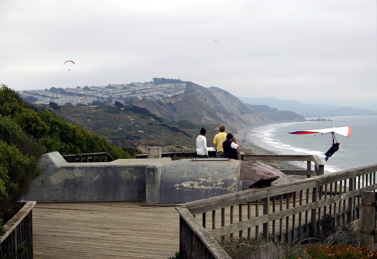
The battery emplacements are worth a close look. Built during World War II and the Cold War as part of the Harbor Defenses of San Francisco, these concrete gun platforms and observation bunkers are now open to exploration on foot. The thick concrete walls, rusted iron fixtures, and darkened interior passages carry a specific kind of quiet weight. They're not formally interpreted with signage at every turn, which makes them feel discovered rather than curated.
Tickets & tours
Hand-picked options from our booking partner. Prices are indicative; availability and final rates are confirmed when you complete your booking.
Sonoma and Napa Valley wine tour from San Francisco
From 127 €Instant confirmationFree cancellationGo City | San Francisco Explorer Pass
From 76 €Instant confirmationFree cancellationMuir Woods and Sausalito guided tour with transportation
From 82 €Instant confirmationFree cancellationSan Francisco CityPASS
From 77 €Instant confirmationFree cancellation
Hang Gliding: The Unexpected Spectacle
Fort Funston is one of the premier urban hang gliding launch sites in the United States. The consistent onshore winds that push up the bluff face create reliable lift conditions, and on afternoons when the wind is right, you'll typically see several hang gliders launching from the designated area near the main parking lot and riding the lift above the bluffs. The sight of colorful wings banking against an ocean backdrop, with San Francisco's skyline faintly visible to the north, is one of those unexpected urban moments.
The launch area has a small observation deck where spectators can watch at close range. Conditions are most reliable in the late afternoon during spring and summer, when the marine layer has pulled back enough to generate clean lift. On overcast or windless days, there may be no activity at all, so treat it as a bonus rather than a guarantee.
How the Experience Changes by Time of Day
Early morning at Fort Funston is distinctly different from the midday version. Before 8 a.m., the parking lot is sparse, the air is cold and damp, and the fog often sits close enough to the bluff edge that visibility shrinks to a few hundred feet in any direction. The sound of waves carries up from below without the competing noise of crowds, and the wet sand on the trails holds footprints from overnight activity. This is the version of Fort Funston that local runners and serious dog owners prefer.
By midday, the atmosphere shifts. Fog typically clears between late morning and early afternoon, revealing the full sweep of coast. This is when the light is cleanest for photography, when the battery emplacements are warm to the touch, and when the hang gliders are most likely to be active. The trails fill up with a mix of families, leashed and off-leash dogs, and casual walkers.
Late afternoon brings golden light across the dunes and a return of the onshore wind. Sunset from the bluff edge, when it's clear, is striking, with the sun dropping into the Pacific without obstruction. However, the parking lot empties quickly after sunset and the trails can feel isolated after dark. The park's year-round dawn-to-dusk hours should be taken seriously.
⚠️ What to skip
San Francisco's summer months (June through August) are often cool and foggy at Fort Funston, with temperatures in the low 60s°F and frequent marine layer that can obscure views entirely. September and October are statistically the warmest and clearest months for a coastal visit here.
Getting There and Practical Logistics
Fort Funston is located off Skyline Boulevard (CA-35) in southwest San Francisco, reached via Fort Funston Road. The main parking lot is free and reasonably sized, but fills up on weekend mornings — typically by around 9:30 to 10 a.m. If it's full, there's limited street parking along Skyline Boulevard, but the walk-in distance can add time. Arriving before 9 a.m. on weekends solves the parking issue entirely.
For visitors without a car, getting to Fort Funston by public transit takes some planning. Muni serves the broader area, but the site is not directly on a high-frequency route. Rideshare (Uber, Lyft) is the most direct option from central San Francisco, and the ride from downtown typically takes 20 to 30 minutes depending on traffic. For guidance on navigating the city's transit options, the getting around San Francisco guide provides current route and fare context.
Dress in layers regardless of the season. The bluff is exposed and the wind can be sharp even on sunny days. Footwear with grip is useful if you plan to descend to the beach — the sand on the access paths is loose and deep. There are restroom facilities at the main parking area. No food or drink vendors operate on-site, so bring water.
Photography at Fort Funston
The site offers several distinct photographic subjects: the concrete battery emplacements against the sky, the bluff edge with ocean backdrop, the dune vegetation in close-up, and the hang gliders in flight. For the gliders, a telephoto lens in the 200–400mm range gives the best results from the observation area. For landscape work, the bluff-edge shots are strongest in the 30 to 45 minutes after the marine fog clears, when soft diffuse light still covers the sand before the midday glare sets in.
Fort Funston's coastal vantage point also opens up wider photographic possibilities across the San Francisco shoreline. Pairing a visit here with a stop at the Lands End Trail to the north gives a full spectrum of the city's wild Pacific edge in a single day.
Who This Place Is For, and Who Might Not Enjoy It
Fort Funston suits visitors who want unstructured outdoor time without a formal itinerary. There are no admission booths, no audio guides, no scheduled programming. You arrive, you walk, you watch the ocean or the gliders, and you leave when you're ready. That lack of structure is the whole point for a certain kind of traveler.
Visitors focused on San Francisco's cultural and architectural highlights may find the 30-minute drive to the southwest edge of the city harder to justify relative to other options. The first-time visitor guide to San Francisco can help you decide where Fort Funston fits into a tighter itinerary.
Mobility considerations are real here. The main bluff-top trail is manageable for most visitors, but the beach access paths are sandy, steep, and uneven. Visitors with limited mobility should call the NPS information line at (415) 561-4700 ahead of time for current conditions. The site is also entirely unsheltered from wind and weather, which can make it uncomfortable for young children on cold or foggy days.
Insider Tips
- The battery emplacements on the bluff are most atmospheric in the early morning fog, when the concrete interiors hold cold air and the ocean is audible but invisible below. Bring a flashlight if you want to explore the darker passages.
- If you want to watch hang gliding, check wind conditions before you go. The gliders need consistent onshore winds, which are most reliable on spring and summer afternoons. A calm or overcast day may mean no activity at the launch site at all.
- The descent paths to the beach are not marked with difficulty ratings, but the northernmost access trail is shorter and less steep than the main southern route. It's still soft, deep sand, but the angle is more forgiving.
- Fort Funston connects to the broader Coastal Trail network. Walking north from the main parking area eventually links to Ocean Beach and, beyond that, to the Cliff House area, making a longer half-day coastal route possible without needing a car shuttle.
- Dogs are allowed off-leash in designated areas, which makes this one of the most dog-friendly spots in the city. However, the off-leash zones have specific boundaries — follow the posted signs carefully, as NPS rangers do patrol the area and may enforce leash rules outside those zones.
Who Is Fort Funston For?
- Dog owners looking for off-leash space with serious room to run
- Hikers and walkers who want Pacific coastal views without crowds or entry fees
- Photographers interested in military ruins, coastal landscapes, or hang gliding action
- Visitors spending several days in San Francisco who want one morning away from the urban core
- Families with older children comfortable on sandy, uneven terrain
Nearby Attractions
Combine your visit with:
- 16th Avenue Tiled Steps
The 16th Avenue Tiled Steps Project is a community-made mosaic staircase of 163 steps stretching through San Francisco's Golden Gate Heights neighborhood (a sub-area of the Inner Sunset), depicting a journey from the ocean floor to the night sky. It's free, photogenic, and connects to one of the city's best lesser-known hilltop viewpoints.
- Angel Island State Park
Angel Island State Park sits in the middle of San Francisco Bay, offering miles of hiking trails, layers of military and immigration history, and 360-degree views of the city skyline, Marin headlands, and beyond. Getting there requires a ferry, which is part of the appeal — the island feels removed from city life, even though San Francisco is visible the entire time.
- Asian Art Museum of San Francisco
One of the largest Asian art collections in the Western world, housed in a transformed Beaux-Arts landmark at Civic Center. From ancient Chinese bronzes to contemporary Southeast Asian installations, the museum rewards careful visitors who know what to look for.
- UC Berkeley Campus
The University of California, Berkeley sits on a hillside above San Francisco Bay, offering free access to striking Beaux-Arts architecture, landmark museums, and open green spaces. A short BART ride from San Francisco, it rewards curious visitors with history, intellectual energy, and some of the best campus scenery in the country.