Chicago River Bascule Bridges: Engineering in Plain Sight
Spanning the Chicago River and its branches, the city's trunnion bascule bridges are among the most concentrated collections of movable bridge engineering in North America. Built between 1900 and 1940, they are free to walk across, fascinating to watch in operation, and best understood as part of a wider exploration of the river corridor.
Quick Facts
- Location
- Chicago River crossings throughout the Loop and surrounding downtown neighborhoods, Chicago, IL
- Getting There
- Multiple CTA 'L' stations along the Brown, Pink, Green, Orange, Purple, and Blue lines serve river crossings; State/Lake and Washington/Wells are useful Loop starting points
- Time Needed
- 30 minutes for a single bridge; 2–3 hours for a proper walking tour of multiple crossings
- Cost
- Free to walk across; no admission or ticketing
- Best for
- Architecture enthusiasts, photographers, engineering history fans, and anyone walking the Chicago Riverwalk
What Are the Chicago River Bascule Bridges?
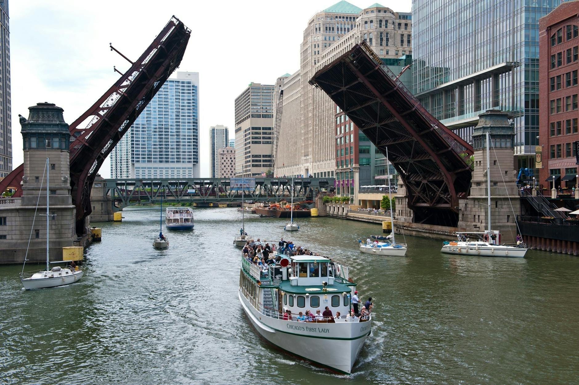
The Chicago River Bascule Bridges are a group of movable steel bridges that cross the Chicago River, its North Branch, and its South Branch within the I&M Canal National Heritage Corridor in and around downtown Chicago. They use the Chicago-style trunnion bascule design: a system of counterweights, gears, and electric motors that allows the bridge leaves to rotate upward and back, clearing the river for taller vessel traffic. The engineering approach was developed and refined during the first decades of the twentieth century, with most bridges in the downtown core built between 1902 and 1940.
These are not museum pieces. They are working infrastructure. Freight vessels, tour boats, and tall-masted sailboats still trigger openings today, and when a bridge goes up, it does so with a mechanical authority that draws crowds to the railings. For anyone interested in civil engineering, industrial history, or simply the working anatomy of a city, the bridges reward close attention.
ℹ️ Good to know
The bridges are documented in the Historic American Engineering Record (HAER) held by the Library of Congress, which attests to their national significance as a collection of early-twentieth-century movable bridge technology.
The Engineering: How a Trunnion Bascule Works
The word bascule comes from the French for seesaw, and that is essentially the operating principle. Each leaf of a Chicago-style trunnion bascule bridge rotates around a fixed horizontal pin called a trunnion. A large concrete counterweight, typically housed in a pit below the road deck, balances the weight of the leaf. When the bridge operator activates the electric motors, gears drive the trunnion and counterweight system, and the leaf rises smoothly without requiring enormous energy to lift.
The Chicago-style variant became the dominant bascule design in North America during the early twentieth century because it was quick-opening and mechanically efficient compared with earlier movable-span designs. Chicago's flat terrain, the heavy commercial traffic on the river, and the city's grid of downtown streets created both the demand and the engineering incentive for a bridge type that could open in roughly a minute and close quickly enough to keep pedestrian and vehicle traffic moving.
Look down into the bridge pit when a crossing is raised and you can sometimes see the counterweight mass and the trunnion housing. The operator houses, small brick or concrete structures positioned at each corner of the bridge deck, are also worth noting. Many retain their original architectural detailing, including decorative cornices and metal window frames, which suggest the civic pride that once accompanied serious public works projects.
Tickets & tours
Hand-picked options from our booking partner. Prices are indicative; availability and final rates are confirmed when you complete your booking.
Chicago's River and Lake architecture speedboat cruise
From 37 €Instant confirmation90-min architecture boat tour on the Chicago river
From 32 €Free cancellationOdyssey Chicago river architectural lunch cruise
From 86 €Instant confirmationPremium Chicago River architectural brunch on the Odyssey
From 85 €Instant confirmation
Walking the Bridges: A Practical Route
The densest concentration of bascule bridges sits within a short walk of the Loop. A useful starting point is the Michigan Avenue Bridge (officially the DuSable Bridge), which carries Michigan Avenue across the main stem of the river at the edge of the Magnificent Mile. From there, walking west along the Chicago Riverwalk puts you within sight of several additional crossings: the Clark Street Bridge, the LaSalle Street Bridge, the Wells Street Bridge, and the Lake Street Bridge among them. Each has its own operating history and visual character.
The Wells Street Bridge is particularly worth pausing on because it carries both vehicle traffic and the elevated Brown and Purple Line tracks. Watching a train cross overhead while boat traffic moves below creates a layered sense of the city's transport history compressed into a single moment. The sound is considerable: steel wheel on steel rail, river water against the concrete piers, traffic passing at street level.
Further west, the North and South Branches of the river carry fewer bridges but sometimes offer a less crowded viewing experience. The Riverwalk itself extends along the main stem, providing a lower-level pedestrian path that brings you close to the waterline and gives a better sense of bridge scale than the street-level crossing alone.
💡 Local tip
The Chicago Architecture Foundation River Cruise passes under or alongside many of the downtown bascule bridges and provides expert commentary on their design and history. It is one of the most efficient ways to see multiple bridges in context.
Watching a Bridge Opening
Bridge openings in the downtown core are not a scheduled spectacle on a daily basis, but during spring and fall there is a scheduled series of “bridge lifts” for recreational sailboats that offers a reasonable chance of witnessing one. The river carries tour boats, water taxis, and private vessels from approximately spring through autumn, and taller vessels require bridge lifts. The bridges along the main stem see more activity than those on the branches.
When a lift is about to happen, the operator activates warning lights and audible signals. Traffic barriers lower across the road deck, pedestrians are cleared to waiting areas, and then the leaves begin to rotate upward. The entire sequence, from barrier drop to full opening, takes roughly a minute for a well-maintained crossing. The mechanical sounds during the process, the hum of motors, the grind of rack-and-pinion gearing, and the low creak of the structure taking up the load, are unlike anything in everyday urban experience.
One practical note: bridge lifts temporarily block foot and vehicle traffic, sometimes for several minutes while a vessel transits and the bridge reseats. If you are on a tight schedule, factor in the possibility of a short wait, particularly near the more active crossings on the main stem.
⚠️ What to skip
During the annual spring bridge-lift season on the Chicago River, a series of downtown movable bridges are raised on scheduled days to allow sailboats to move between Lake Michigan and inland harbors, and these lifts can block crossings for several minutes at a time. Check local news before planning a river-level walk during that period.
Time of Day and Seasonal Considerations
Morning light, roughly between 7 and 9 a.m., hits the steel superstructure of the bridges from the east and produces strong shadows that emphasize the structural geometry. This is the best window for photography of the Michigan Avenue and Wabash Avenue bridges. The Riverwalk is quieter at this hour, and the sound of the river is more audible without peak foot traffic.
Midday in summer brings the most pedestrian activity, which can make the Riverwalk feel congested near the main tourist nodes. That said, summer also brings the highest frequency of boat traffic and therefore the best odds of seeing a bridge raised. Late afternoon in autumn, when the low sun catches the orange-toned patina on older bridge elements, offers some of the most atmospheric conditions for extended exploration.
Winter visits are genuinely worthwhile for anyone equipped for the cold. Chicago's winters are serious, with mean January temperatures around -3 to -1 degrees Celsius (about 26 to 30 degrees Fahrenheit), and strong wind off the river adds significant chill factor. However, the bridges are far less crowded, the structural steel often accumulates frost or ice that highlights the mechanical joints, and the Riverwalk takes on a quiet, almost industrial character that is very different from summer. Wear insulated footwear and wind-resistant outer layers.
Historical and Cultural Context
The Chicago River was the commercial spine of a rapidly industrializing city in the late nineteenth and early twentieth centuries. Grain, lumber, and manufactured goods moved through it, and the bridges that crossed it had to accommodate both the street grid of a fast-growing metropolis and the waterborne freight traffic that the economy depended on. The Chicago-style trunnion bascule design emerged as the answer to that specific pressure, and the bridges built between 1902 and 1940 represent the period when the city was investing most heavily in civic infrastructure. The history of Chicago's architecture is often told through its skyscrapers, but the bridges are an equally significant chapter in the built record of the city.
The DuSable Bridge on Michigan Avenue, named for Jean Baptiste Point DuSable, the Haitian-born trader widely recognized as Chicago's first permanent non-Indigenous settler, carries additional historical weight. Its four bridgehouse pylons are decorated with bronze relief panels depicting scenes from Chicago's early history, including the Fort Dearborn Massacre of 1812 and the rebuilding after the Great Chicago Fire of 1871. These panels are easy to miss if you are focused on the bridge mechanism itself. The bridge sits at the northern edge of Magnificent Mile and Streeterville, making it a natural point to connect a bridge walk with wider neighborhood exploration.
For visitors who want structured architectural context, the Chicago Architecture Foundation River Cruise provides narrated context for the bridges alongside the riverfront building stock. The Chicago Architecture Center near Wabash Avenue also has exhibits covering bridge engineering and the broader story of the city's built environment.
Photography Tips and Accessibility
The Riverwalk level provides the most interesting camera angles because it places you below the road deck and lets you frame the bridge structure against the sky or against the buildings lining the opposite bank. A wide-angle lens is useful here. For a raised bridge, the best position is on the adjacent bank, looking across the water at the elevated leaf and its counterweight pit.
The Riverwalk itself is a paved, flat surface accessible to wheelchair users and pushchairs for most of its length, though access points via ramps vary by location. The bridges at street level are standard sidewalk crossings and fully accessible. Note that when a bridge is raised, pedestrians are stopped at barriers and must wait, which can involve standing on a potentially windy bridge deck for several minutes.
Visitors combining the bridges with a broader downtown walk will find that the bridges connect naturally to Millennium Park and the wider Loop on the south and east sides, and to River North on the north bank.
Who Should Skip This
The bridges themselves are not a destination in the conventional sense. There is no visitor center, no interpretive signage at most crossings, no ticketing, and no guarantee of witnessing an opening on any given visit. Travelers who need a structured, time-bounded attraction with clear narrative payoff may find the experience underwhelming without additional research or a guided tour. Families with very young children may find the Riverwalk walk manageable but the bridge mechanism itself hard to convey without dedicated signage.
Anyone with significant mobility limitations should also check current Riverwalk access conditions before visiting, since ramp availability and surface conditions can vary by season, particularly in winter when icing is possible.
Insider Tips
- The operator houses at the four corners of each bridge are small architectural treasures in their own right. The ones on the Michigan Avenue Bridge retain particularly fine brickwork and metalwork details. Look for the Chicago Department of Transportation plaques that list construction dates and original engineers.
- If you want to watch a bridge open without the surrounding crowd, the crossings west of the Loop on the South Branch, such as the Halsted Street Bridge, see lighter foot traffic and operate when commercial or larger recreational vessels need passage.
- The annual spring bridge-raising, when the city lifts nearly all downtown movable bridges simultaneously for maintenance inspection, draws photography crowds but completely halts crossings. If you are planning a Riverwalk walk, avoid this day. If you want to photograph raised bridges en masse, it is a rare opportunity.
- The Wells Street Bridge is a rare downtown crossing that carries both a road deck and elevated rail tracks. Standing on the pedestrian walkway while a Brown Line train crosses above and a river tour boat passes below creates a genuinely disorienting sense of the city's layered infrastructure.
- The relief panels on the DuSable Bridge bridgehouse pylons are at eye level and almost always unattended. Give yourself five minutes to read the scenes depicted. They function as a compressed street-level history of early Chicago that most visitors walk past without noticing.
Who Is Chicago River Bascule Bridges For?
- Architecture and engineering enthusiasts who want to examine movable bridge technology up close and for free
- Photographers looking for structural geometry, reflections, and urban texture along the river corridor
- History-minded walkers connecting the built fabric of the Loop to Chicago's industrial and commercial past
- Visitors already walking the Riverwalk who want interpretive depth beyond the café and tourist boat layer
- Repeat visitors to Chicago who have covered the major ticketed attractions and want a different kind of encounter with the city
Nearby Attractions
Other things to see while in The Loop:
- Art Institute of Chicago
One of the largest and most visited art museums in the United States, the Art Institute of Chicago anchors the eastern edge of the Loop with a collection of over 300,000 works spanning 5,000 years. From Georges Seurat's pointillist masterpiece to Grant Wood's American Gothic, the highlights alone demand the better part of a day.
- Buckingham Fountain
The Clarence Buckingham Memorial Fountain is one of the largest decorative fountains in the world, sitting at the heart of Grant Park since 1927. Free to visit during its seasonal run from spring through mid-October, it puts on hourly water displays and a nightly illuminated show that draws crowds from across the city.
- Chicago Architecture Center
Housed in Mies van der Rohe's One Illinois Center on the Chicago River, the Chicago Architecture Center packs nearly 10,000 square feet of exhibition space, a landmark scale model of the city, and access to some of the country's most informative architecture tours. It's the most comprehensive entry point into understanding what makes Chicago's skyline one of the world's most significant.
- Chicago Architecture Foundation River Cruise
The Chicago Architecture Center River Cruise aboard Chicago's First Lady is the most authoritative way to read the city's skyline. In 90 minutes, trained docents walk you through more than 40 landmark buildings across all three branches of the Chicago River, connecting architectural styles to the human decisions that shaped them.