Chicago Riverwalk: The Loop's Waterfront Walk Worth Your Time
The Chicago Riverwalk is a 1.25-mile public promenade running along the south bank of the Chicago River through the heart of downtown. Free to access, it packs architecture tours, kayak rentals, open-air dining, and river views into a walkable stretch that works equally well as a quiet morning detour or a full afternoon outing.
Quick Facts
- Location
- South bank of the Chicago River, from Lake Shore Drive (Outer Drive Bridge) west to Lake Street, The Loop
- Getting There
- Multiple CTA 'L' stations in the Loop — State/Lake, Washington/Wabash, and Clark/Lake are all within a short walk
- Time Needed
- 20–30 minutes to walk end-to-end; 2–4 hours if you stop for food, a boat tour, or kayaking
- Cost
- Free to access; individual boat tours, kayak rentals, and restaurants charge their own fees
- Best for
- Architecture lovers, casual walkers, families, anyone wanting river-level views of the skyline
- Official website
- www.chicago.gov/city/en/sites/chicagoriverwalk
What the Chicago Riverwalk Actually Is
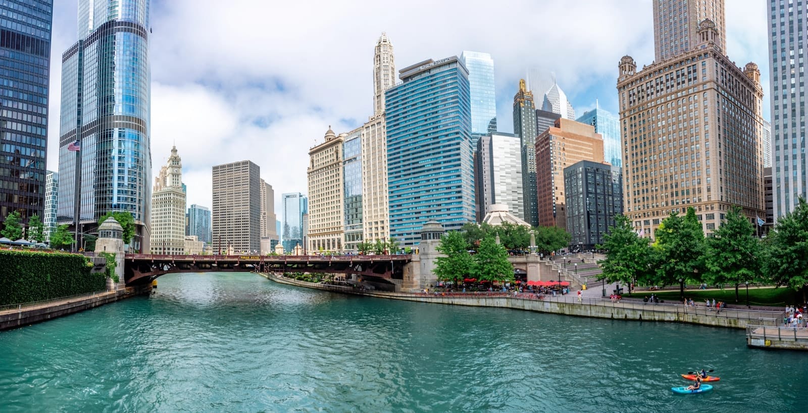
The Chicago Riverwalk is a continuous pedestrian promenade running approximately 1.25 miles (2.0 km) along the south bank of the main branch of the Chicago River. It stretches from the Outer Drive Bridge near Lake Michigan in the east all the way west to Wolf Point near Lake Street, passing under nine bridges and alongside some of the most recognizable buildings in the city's skyline.
At river level, you're below the street grid — literally one level down from the traffic of Wacker Drive. That separation is the key to the whole experience. The city noise stays above you. What you get instead is the low churn of water, the occasional rumble of a tour boat engine, and the echo of voices bouncing off concrete and steel. It is one of the rare places in downtown Chicago where you can stop, stand still, and actually look at the architecture rather than crane your neck from a sidewalk.
ℹ️ Good to know
The Riverwalk is generally open daily from 6:00 a.m. to 11:00 p.m. Access is free at all times. Concessions, restaurants, and boat operators are mostly seasonal — expect many to be closed or on reduced hours from late autumn through early spring.
History and How It Got Here
For most of the twentieth century, the Chicago River's downtown banks were industrial back-of-house space: loading docks, utility infrastructure, and the undersides of elevated roads. The water itself famously runs backwards — in 1900, Chicago engineers reversed the river's flow away from Lake Michigan to protect the city's drinking water supply, a feat of civil engineering that still ranks among the most audacious urban infrastructure projects in American history.
The modern Riverwalk's origins trace to the reconstruction of Wacker Drive in 2001, which created the physical base for a continuous lower-level promenade. The project that transformed it into what visitors see today began in earnest in 2012 under Mayor Rahm Emanuel, with a major expansion west of State Street that added six distinct zones, each designed by the landscape architecture firm Ross Barney Architects in partnership with Sasaki Associates. The project was funded in part through federal transportation grants.
Those six zones — Marina, Cove, River Theater, Water Plaza, Jetty, and Confluence — give the Riverwalk a choreographed quality that distinguishes it from a simple waterfront path. For a deeper look at how this project fits into Chicago's broader design legacy, the Chicago Architecture Center maintains detailed documentation of the Riverwalk's design history and is worth visiting before or after your walk.
Tickets & tours
Hand-picked options from our booking partner. Prices are indicative; availability and final rates are confirmed when you complete your booking.
Riverwalk self-guided audio walking tour in Chicago
From 13 €Instant confirmationFree cancellationGo City | Chicago All-Inclusive Pass
From 127 €Instant confirmationFree cancellationiFLY Chicago Lincoln Park indoor skydiving experience
From 126 €Instant confirmationFree cancellationiFLY Chicago Rosemont indoor skydiving tickets
From 117 €Instant confirmationFree cancellation
The Six Zones: What You'll Find Where
Walking west from the lakefront end, the zones transition in character. The Marina zone near the east end is the most active: boat slips, water taxis, and architecture tour departures make it feel like a working waterfront. Early mornings here, when the river is mirror-flat and tour boats haven't started running yet, the reflections of the towers above are almost perfect.
The Cove section curves inward and features a floating wetland garden. It's a quieter pocket where you'll often find people sitting on the low timber seating reading, eating lunch, or just watching the river traffic. The River Theater uses stepped limestone seating that descends toward the water — an amphitheater without a stage, where the river itself provides the view. On weekday lunch hours it fills with office workers eating sandwiches in the sun.
Further west, the Water Plaza features interactive water jets popular with children in summer. The Jetty zone extends small planting islands and fishing piers out over the water. The westernmost section, Confluence, marks the meeting point of the Chicago River's three branches and offers some of the most dramatic angular views of downtown towers framed between bridge piers. This end of the walk is noticeably less crowded, even in peak season.
💡 Local tip
If you only have 20 minutes, walk to the Confluence zone at the western end. The view back east toward the bridges and towers is the one most photographers miss — and you'll share it with far fewer people than the popular Michigan Avenue entry point.
How the Experience Changes by Time of Day
Early morning, roughly 6:30 to 8:30 a.m., is when the Riverwalk belongs almost entirely to joggers, cyclists, and the occasional dog walker. The light comes in low from the east and catches the glass facades of the towers along Wacker Drive at sharp angles. The river surface is calm before boat traffic begins. If you want photographs without people in every frame, this is your window.
Midday on a warm weekday transforms the space entirely. Restaurant terraces fill up, the architecture tour boats run continuous departures, kayakers navigate between bridge piers, and the River Theater seating is occupied from top to bottom. The smell shifts too: grilled food from the concession stands mixes with the faint mineral scent of river water. It's genuinely lively without feeling chaotic, partly because the path is wide enough to absorb the crowds.
Late afternoon and evening bring a different crowd. After 5:00 p.m., the office buildings above empty out and some of that foot traffic descends to the Riverwalk for after-work drinks at the outdoor bars. The towers catch the golden light and hold it longer than street level does. By 9:00 p.m. in summer, the space is quiet again but still occupied — couples, late-night walkers, the occasional photographer doing long-exposure river shots. The 11:00 p.m. closing is rarely enforced aggressively, but most visitors are gone well before then.
Things to Do Here Beyond the Walk Itself
The most popular paid activity on the Riverwalk is an architecture boat tour. Several operators depart from the eastern Marina zone, offering narrated cruises of 60 to 90 minutes that cover the river's architectural history from the water. The Chicago Architecture Foundation River Cruise is the best-regarded option, run in partnership with the Chicago Architecture Center, and should be booked in advance during summer weekends.
Kayak rentals are available in summer, typically from operators stationed near the Kayak Launch zone. Paddling under the city's bascule bridges at water level — looking up at their rusted iron undersides — is a genuinely different perspective on downtown. The Chicago River kayaking experience rewards those willing to show up early when boat traffic is minimal.
Fishing is permitted at the Jetty zone, and people do actually fish here. The river supports populations of largemouth bass, common carp, and channel catfish — a quiet reminder that the water quality has improved dramatically over the past three decades following sustained cleanup efforts.
For dining, options range from casual grab-and-go spots to sit-down riverside terraces. Prices run higher than comparable food a few blocks away — you're paying for the water views. If you want a proper meal without the premium markup, consider using the Riverwalk walk as a route to the West Loop, which begins not far west of where the promenade ends.
Practical Information for Visitors
Access to the Riverwalk itself is free, though official hours are generally 6:00 a.m. to 11:00 p.m. Entry points are available at most of the bridges crossing the river along Wacker Drive — stairways descend to the lower level at Michigan Avenue, State Street, Dearborn, Clark, LaSalle, Wells, and Franklin Streets. Most stairways are uncovered, so rain turns the stone steps slick. Several access points also have ramps; visitors with mobility considerations should check the City of Chicago's official Riverwalk page for current accessibility details at specific entry points.
The nearest CTA 'L' stations are all within a few minutes' walk: State/Lake, Washington/Wabash (served by the Brown, Green, Orange, Pink, and Purple Express lines), and Clark/Lake (served by the Blue, Brown, Green, Orange, Pink, and Purple Express lines) all deposit you within easy walking distance of Riverwalk access points. For a full picture of the Loop's transit options, the guide to getting around Chicago covers CTA 'L' lines, fares, and passes in detail.
In summer (roughly May through September), bring sunscreen. The river corridor channels wind, which can make a warm day feel more comfortable than expected — but also means sun exposure from reflected light off the water adds up faster than most visitors anticipate. Comfortable walking shoes matter more than on street-level sidewalks because the paving surfaces vary: polished concrete, limestone pavers, and wooden dock sections. In winter, sections of the lower promenade can be icy and some concession and access areas close; the street-level Wacker Drive remains passable year-round.
⚠️ What to skip
The Riverwalk has limited shade. On hot summer days (July highs average around 29°C / 84°F), the concrete and stone surfaces retain heat and the water provides only partial relief. Bring water, especially if you're spending more than an hour outdoors.
Who Should Temper Their Expectations
The Riverwalk is occasionally oversold as a destination in itself. If you're visiting in late October through March, the honest picture is considerably different from the summer one: many concession operators are closed, the outdoor seating is gone, the boat tours stop running, and what remains is a windy concrete path with impressive bridge views and not much else. It's still a worthwhile 20-minute detour on a dry winter day, but it's not worth planning around.
Travelers looking for green space, trees, or natural surroundings won't find much of it here. The Riverwalk is emphatically an urban experience — concrete, steel, glass, water, and the noise of the city above. If you want lakefront nature, Montrose Beach or the Lakefront Trail give you a very different kind of outdoor experience. The Riverwalk is at its best understood as an architecture walk that happens to be at water level, not a park.
Insider Tips
- The Confluence zone at the western end of the Riverwalk, where the north and south branches of the Chicago River meet, is visually dramatic and almost always less crowded than the Michigan Avenue end. Walk the full length rather than turning back halfway.
- Architecture boat tours sell out on summer weekend afternoons. Book online the morning of your visit, or show up before 10:00 a.m. to get a slot without stress. The Chicago Architecture Center River Cruise specifically tends to have better-informed guides than competing operators.
- The bascule bridges along the Riverwalk are raised for river traffic several times a day in the warmer months, typically during Marine Traffic hours. If you see a bridge going up while you're on the lower level, it's worth pausing to watch — the counterweight mechanisms are visible from directly below.
- For the best skyline photography from the Riverwalk, the Michigan Avenue access point looking west offers the most layered view: multiple bridges receding into the distance with towers on both banks. This shot works best in morning light when the sun comes in from behind you.
- The River Theater zone's stepped limestone seating is one of the least obvious places to sit and eat a takeaway lunch in the Loop — shaded enough in midday, close enough to the water to feel removed from street traffic, and rarely as crowded as it looks from above.
Who Is Chicago Riverwalk For?
- Architecture and design enthusiasts who want a ground-level perspective on the Chicago skyline
- First-time visitors to Chicago looking for a free orientation to downtown
- Families with children in summer, particularly the Water Plaza zone and kayak activities
- Travelers with a tight schedule who want to combine transit between Loop attractions with something worth seeing in between
- Photographers working in early morning light, when the river is still and the bridges frame the towers cleanly
Nearby Attractions
Other things to see while in The Loop:
- Art Institute of Chicago
One of the largest and most visited art museums in the United States, the Art Institute of Chicago anchors the eastern edge of the Loop with a collection of over 300,000 works spanning 5,000 years. From Georges Seurat's pointillist masterpiece to Grant Wood's American Gothic, the highlights alone demand the better part of a day.
- Buckingham Fountain
The Clarence Buckingham Memorial Fountain is one of the largest decorative fountains in the world, sitting at the heart of Grant Park since 1927. Free to visit during its seasonal run from spring through mid-October, it puts on hourly water displays and a nightly illuminated show that draws crowds from across the city.
- Chicago Architecture Center
Housed in Mies van der Rohe's One Illinois Center on the Chicago River, the Chicago Architecture Center packs nearly 10,000 square feet of exhibition space, a landmark scale model of the city, and access to some of the country's most informative architecture tours. It's the most comprehensive entry point into understanding what makes Chicago's skyline one of the world's most significant.
- Chicago Architecture Foundation River Cruise
The Chicago Architecture Center River Cruise aboard Chicago's First Lady is the most authoritative way to read the city's skyline. In 90 minutes, trained docents walk you through more than 40 landmark buildings across all three branches of the Chicago River, connecting architectural styles to the human decisions that shaped them.