Cap de la Hève: Le Havre's Wild Cliff Edge Above the English Channel
Cap de la Hève is a dramatic chalk cliff headland rising about 100–115 metres above the English Channel at the northern tip of Sainte-Adresse. Free to access year-round, it marks the boundary between the Côte d'Albâtre and the Baie de Seine, offering panoramic coastal views, a hidden tidal beach, and layers of military history stretching back to the 19th century.
Quick Facts
- Location
- Cap de la Hève, 76310 Sainte-Adresse, north of Le Havre city centre
- Getting There
- On foot or by bike via the coastal promenade from Le Havre's seafront; LiA bus network serves Sainte-Adresse
- Time Needed
- 1.5–3 hours for the walk from the seafront and exploration at the cap
- Cost
- Free — open public coastal site with no admission fee
- Best for
- Cliff walkers, photographers, history seekers, and anyone wanting an escape from the urban grid
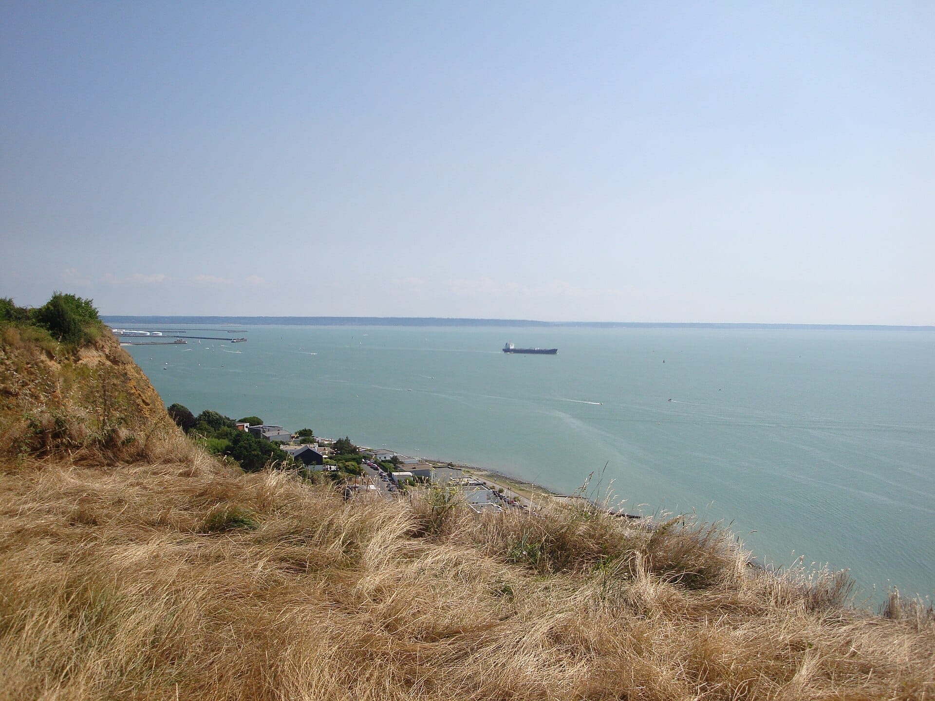
What Cap de la Hève Actually Is
Cap de la Hève is a chalk cliff promontory at the northern edge of Sainte-Adresse, rising to around 100 metres above the English Channel. Geographically, it is one of those rare points where the landscape shifts register completely: to the north, the White cliffs of the Côte d'Albâtre stretch toward Étretat and beyond; to the south and east, the Baie de Seine opens wide, with the port of Le Havre visible in the middle distance and the Seine estuary flattening out toward Honfleur on the opposite bank.
The site was classified as a protected natural area — a 'site classé' — in 1992, covering 141 hectares. It is also designated an Espace Naturel Sensible (Sensitive Natural Area) by the Seine-Maritime department, a status that limits development and maintains natural habitats along the cliff edge and plateau. There are no ticket booths, no barriers, and no opening times. You simply walk to it.
ℹ️ Good to know
The 5 km coastal walking route from Le Havre's seafront to Cap de la Hève ('Front de mer : du sémaphore au cap de la Hève') is a self-guided, free itinerary listed on the City of Le Havre website.
The Walk In: From the Seafront to the Cliff Edge
The most logical approach is to begin on Le Havre's seafront promenade and follow the coast north. The first stretch runs along the flat, exposed seafront past the city beach, where the wind off the Channel is almost always noticeable — sometimes a mild headwind, sometimes something more insistent. In summer, this section feels cosmopolitan and unhurried. In winter or autumn, you are likely to have it largely to yourself, which has its own appeal.
As you move into Sainte-Adresse, the character shifts. The low coastal terrace gives way to small villas and gardens, and the path begins to rise. The gradient is gradual enough that most reasonably fit walkers will not find it taxing, but the change in elevation becomes visible: the horizon widens, the port cranes shrink, and the pale chalk of the cliffs appears more clearly ahead.
If you are combining this walk with a stop in Sainte-Adresse itself, the village offers a quieter pause before the final approach to the cap. The Impressionist viewpoints in Sainte-Adresse are worth a brief detour — Monet painted this coastline in the 1860s, and looking south from the same vantage points, it is not difficult to understand why.
Tickets & tours
Hand-picked options from our booking partner. Prices are indicative; availability and final rates are confirmed when you complete your booking.
Customized private D-day Normandy landing excursion from Le Havre
From 1.300 €Instant confirmationFree cancellationFull-day trip to Giverny and Rouen from Le Havre
From 1.200 €Instant confirmationFree cancellation
At the Cap: What You See and Feel
The summit area of Cap de la Hève is not manicured. Grasses, low scrub, and chalk outcrops define the plateau. There are no cafés, no gift shops, and no interpretation panels beyond basic signage. This is not a criticism — it is precisely what the place offers that most urban viewpoints cannot.
Standing at the edge, the scale registers quickly. The cliff drops roughly 100 metres to the water. On clear days the view extends across to the Calvados coastline to the south-west, and north along the white chalk faces that characterise the Alabaster Coast. The sound here is almost always wind and seabirds — herring gulls, and in spring, northern fulmars nesting in the chalk faces. In the morning, when the light comes in from the east and catches the Channel, the surface takes on a metallic quality that photographers tend to find particularly productive.
Afternoon visits are more comfortable in summer, when the elevated plateau catches the afternoon sun and the light softens for photography. In autumn and winter, the same spot becomes considerably rawer — westerly Atlantic systems push directly into the cap, and the wind can be strong enough to require a firm footing near the edge. That said, winter visits on calm days carry a different reward: total solitude at one of the most dramatic coastal points in Normandy.
💡 Local tip
For the best light and fewest people, aim for early morning on a weekday. Weekends in summer see families, dog walkers, and cyclists sharing the path. Arrive before 9am and you will often have the cliff edge to yourself.
The Hidden Beach Below: Plage du Bout du Monde
One practical detail that most visitors overlook: there is a beach at the foot of the cliff. Locally nicknamed 'la plage du bout du monde' (the beach at the end of the world), it is reached by a stairway descending from the cliff top. The stairway is steep and the descent is not short. At the bottom, you arrive at a narrow strip of pebble and sand that sits below the full height of the cliff, sheltered from most of the prevailing wind, with the sensation of being completely cut off from the road network above.
This is not a beach for sunbathing infrastructure — there are no lifeguards, no facilities, and no shade beyond the cliff itself. It is tidal, so the accessible strip varies considerably with the sea state. Anyone with mobility limitations should be aware that the stairway descent makes this part of the site inaccessible. The cliff-top views are the main draw, and they require no stairs.
Military History and Fortifications
Cap de la Hève has been militarily significant for well over a century. Its elevation and position at the mouth of the Seine made it a logical fortification point. A battery was installed here in the 19th century and later remodelled. By 1892, a new battery had been constructed to house heavy guns. The scale of that armament gives a sense of how seriously the position was regarded strategically.
During World War II, German forces made extensive use of the site, adding further fortifications to the existing structures. The broader context of Le Havre's wartime experience — the port's role, the Allied bombing campaigns, and the city's near-total reconstruction — is covered in detail in the Le Havre WWII history guide. At Cap de la Hève, the remaining concrete structures and earthworks are visible to attentive walkers. They are not formally interpreted or museumified, but they are substantial enough to be clearly identifiable.
The combination of 19th-century artillery emplacements and 20th-century German occupation layers gives the headland a weight that goes beyond simple coastal scenery. For visitors who come specifically for this history, the site rewards careful exploration — but also rewards a bit of prior research, since there is minimal on-site interpretation.
Practical Guidance: Getting There, Weather, and Photography
The walk from Le Havre's seafront is approximately 5 km one way. Allow at least an hour for the approach walk on its own, more if you stop at the Sainte-Adresse viewpoints along the way. The return is the same path, so budget at least 2.5 to 3 hours total if you want any time at the cap itself. The LiA bus network connects Le Havre city centre with Sainte-Adresse, which shortens the walking distance if you prefer to skip the lower coastal section.
Weather affects this walk significantly. The Côte d'Albâtre is exposed to Atlantic weather systems, and conditions can change quickly. In strong wind and rain, the cliff-edge paths become slippery and the walk becomes an endurance exercise rather than a pleasure. Check the forecast before you go — the site is free and always there. Normandy's maritime climate means there is rarely a perfect forecast window, but days with broken cloud and moderate wind are actually excellent for photography: the light is dynamic and the sea has texture.
For photography, a wide-angle lens handles the panoramic clifftop views well, while a longer focal length lets you isolate the chalk cliff faces and the scale of the port infrastructure to the south. The lighthouse visible near the cap area adds a clear landmark on overcast days when the horizon is soft.
⚠️ What to skip
Stay well back from the cliff edge. Chalk cliffs erode continuously and edges can be unstable. This applies especially after rain, when the surface near the top can be soft. There are no barriers at many points along the edge.
Is Cap de la Hève Worth the Walk?
Cap de la Hève is not an attraction that delivers its value passively. It asks something of you: a 5 km walk each way, tolerance for exposed weather, and an interest in landscape for its own sake. If those terms suit you, it delivers a quality of coastal experience that is genuinely hard to find within walking distance of a city the size of Le Havre. If you are travelling with young children, consider that the path length and cliff-edge nature of the site require sustained attention. The Le Havre with kids guide has alternative suggestions for family days on the coast.
For cruise passengers with limited time in port, Cap de la Hève is probably not the highest priority — the 10 km round trip on foot from the seafront is a significant time commitment against a short port window. Visitors with a full day and an interest in walking the coastline will find it among the most memorable hours they spend in Le Havre.
If the walk appeals but you want to build it into a fuller day, the Le Havre walking tour guide outlines how to connect the seafront, Sainte-Adresse, and the cap into a single coherent itinerary.
Insider Tips
- The returning walk south gives you a completely different visual experience — the port and the city come into view progressively as you descend toward Le Havre, and the scale of the industrial waterfront from above is genuinely striking. Do not just turn around and retrace without pausing to look.
- If visibility is good, the white cliffs of the English coast are occasionally visible from the cap on very clear days — rare, but it happens. Check weather apps for visibility forecasts rather than just cloud and rain.
- The plateau area directly behind the cliff edge has short grass paths that loop around the fortification remnants. These are not signposted but are easy to follow and add 20–30 minutes of exploration without requiring any technical hiking ability.
- LiA bus services run from Le Havre city centre to Sainte-Adresse, cutting the walking distance in half if you want to focus your energy on the cliff itself rather than the full coastal approach.
- Bring water and a windproof layer regardless of the forecast. The plateau offers no shelter and no facilities, and even warm summer days turn cold quickly in a Channel headwind.
Who Is Cap de la Hève For?
- Coastal walkers and hikers looking for a genuine cliff-edge experience close to an urban base
- Photographers seeking wide channel panoramas and dynamic Atlantic light conditions
- History enthusiasts interested in 19th-century artillery fortifications and WWII coastal defences
- Visitors wanting solitude and open landscape after time in Le Havre's urban centre
- Cyclists exploring the Vélomaritime coastal route, for whom the cap is a natural waypoint
Nearby Attractions
Other things to see while in Sainte-Adresse:
- Cimetière Sainte-Marie
Cimetière Sainte-Marie is one of France's officially listed remarkable cemeteries, covering 18 hectares on the hills north of Le Havre with over 20,000 tombs. It holds 2,063 Commonwealth war graves from both World Wars, an 1861 chapel, and layers of local history that reward unhurried exploration.
- Impressionist Viewpoints (Sainte-Adresse & Cap de la Hève)
The clifftops and seafront promenade of Sainte-Adresse and Cap de la Hève are where Claude Monet found some of his most enduring compositions. A marked outdoor trail with interpretive panels connects the exact spots where canvases like 'Terrace at Sainte-Adresse' and 'La Pointe de la Hève' were painted, all freely accessible and open at any hour.
- Chapelle Notre-Dame-des-Flots
Perched on the heights of Sainte-Adresse above the Seine estuary, Chapelle Notre-Dame-des-Flots is a neo-Gothic chapel built in the late 1850s as a sanctuary for sailors and fishermen. Its interior fills with ex-votos, model ships, and votive paintings dedicated to those lost at sea, making it one of the most quietly moving heritage sites in the Le Havre area. Admission is free.
- Plage de Sainte-Adresse
Plage de Sainte-Adresse is a large pebble beach on the northwestern edge of Le Havre, framed by a historic jetty and sweeping views across the Seine estuary. Free, unhurried, and steeped in Impressionist history, it rewards visitors who make the short trip from the city centre.