Qixing Mountain Trail: Hiking Taipei's Highest Peak in Yangmingshan
The Qixing Mountain Trail (七星山步道) leads to the highest point in Taipei City at 1,120 metres, passing volcanic fumaroles, alpine meadows, and stone-paved ridges inside Yangmingshan National Park. The 4.5 km route is free, well-marked, and achievable in a half-day, making it one of the most rewarding hikes accessible by public bus from central Taipei.
Quick Facts
- Location
- Yangmingshan National Park, Beitou District, Taipei City
- Getting There
- MRT Jiantan Station (Red Line), then Bus S15 to Yangmingshan Bus Terminal plus a connecting park bus to Lengshuikeng or Xiaoyoukeng
- Time Needed
- 3–5 hours (full loop including transport)
- Cost
- Free to enter; standard MRT/bus fares apply
- Best for
- Hikers, nature lovers, volcano enthusiasts, clear-day views of Taipei
- Official website
- www.ymsnp.gov.tw/en/sglarticle/mt.-qixing-nature-walk
What Is Qixing Mountain and Why Does It Matter?
Seven Star Mountain, known in Mandarin as Qixingshan (七星山), is a dormant stratovolcano and the tallest mountain entirely within Taipei City limits, peaking at about 1,120 metres above sea level. The mountain takes its name from the seven distinct summits visible along its ridge when viewed from the lowlands, though most hikers target either the main peak (主峰) or the east peak (東峰). Both sit inside Yangmingshan National Park, a protected volcanic landscape that begins barely 20 minutes north of Taipei's urban core by bus.
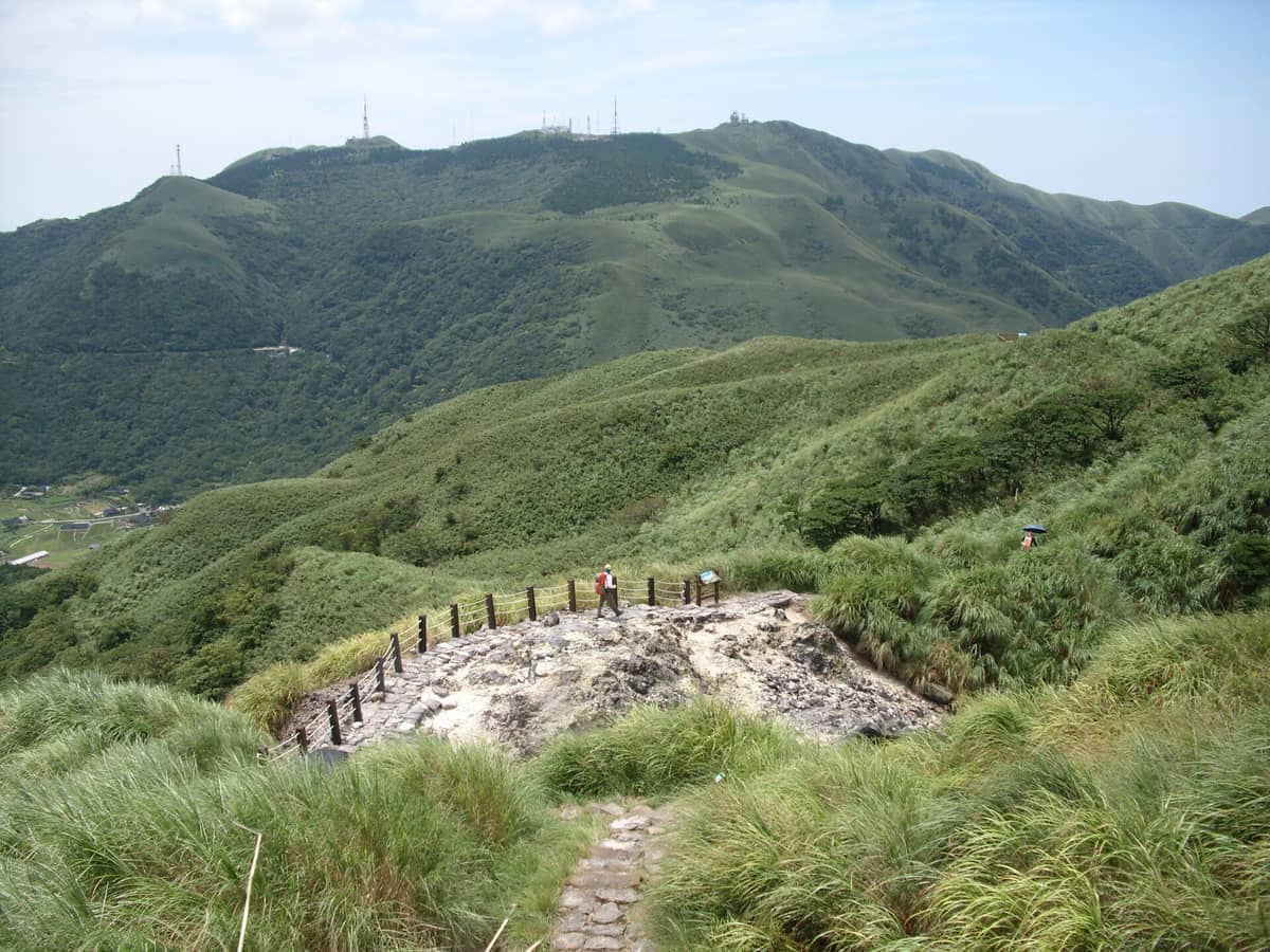
What makes this hike unusual for a city trail is the genuine volcanic character of the terrain. Fumaroles at Xiaoyoukeng, near the northern trailhead, vent sulfurous steam visibly year-round. The smell of sulfur greets you before you see it: a sharp, egg-like odor that fades as you gain elevation and confirms you are walking on geologically active ground. The upper ridgeline, by contrast, is swept clean by wind and often wrapped in mist, with low arrow bamboo covering the slopes in pale green and silver in the cooler months.
ℹ️ Good to know
The official Mt. Qixing Nature Walk is approximately 6.4 km long and connects Lengshuikeng Visitor Center to the Xiaoguanyin stop parking lot via the main and east peaks. Most hikers tackle it as a point-to-point route and return by bus from whichever end they finish at.
The Trail in Detail: What to Expect Underfoot
The entire trail is paved in stone steps, maintained by the national park authority. There is no scrambling, no exposed rock faces requiring handholds, and no trail-finding difficulty. Signage in Chinese and English marks every junction. What the trail does offer is relentless elevation: from the Lengshuikeng Visitor Center at roughly 740 metres to the main peak at about 1,120 metres, the route climbs approximately 380 metres in a short distance, with stretches of steep stone staircase that demand a steady pace.
The route from Lengshuikeng begins through mixed forest with filtered light and the sound of insects and birds. The Shady Tree Trail section in the lower half offers some relief from direct sun, with tall camphor and native broadleaf trees creating a canopy. This changes sharply above the treeline: the upper slopes are open, windswept, and visually dramatic. On clear days from the summit, you can trace the Taipei basin in one direction and the Taiwan Strait in another. Haze and cloud are equally common, and the summit in mist has its own quiet atmosphere, though the views obviously disappear.
From the main peak, a ridge path continues to the east peak before descending toward Xiaoyoukeng, where the fumaroles are most active and the sulfur smell returns. The Xiaoyoukeng observation deck provides a safe vantage point over the steaming vents. From there the Arrow Bamboo Trail section leads down to the Xiaoguanyin stop, where buses return toward central Taipei.
⚠️ What to skip
In April 2025, a wildfire burned parts of the Qixingshan slopes. Authorities temporarily closed sections of the trail and the Xiaoyoukeng parking lot, and buses skipped the Xiaoyoukeng Service Center; check with Yangmingshan National Park for the latest trail status before visiting if wildfire or weather events have occurred recently.
How the Experience Changes by Time and Season
Weekday mornings between 7 and 9 a.m. offer the quietest experience on the trail. Local hikers, many of them older Taipei residents in proper trekking gear, are typically already on their way up while tourist groups have not yet arrived from the city. The light is low and angled, casting long shadows across the stone steps and picking out the texture of the volcanic rock. Temperature at the summit in the morning can be noticeably cooler than in the city below, sometimes by 5–8 degrees Celsius.
Weekends from mid-morning onward, especially during spring cherry blossom season in March and April, bring significantly more foot traffic. The trailheads can feel crowded, and the stone paths up to the peak see a near-constant stream of hikers. For those wanting solitude, this is not the window to choose.
October through April gives the most reliable weather for clear summit views, coinciding with Taipei's drier season. Summer brings high humidity and the risk of afternoon thunderstorms; starting early is especially important from May through September. Winter mornings can be cold and foggy at the summit, with temperatures occasionally dropping near zero at the peak. A windproof layer is worth carrying regardless of how warm it feels in the city when you set out.
For a broader sense of when Taipei's outdoor spaces are at their best, the Taipei hiking guide covers seasonal conditions across multiple trails and parks in the region.
Getting There and Starting the Hike
The most practical approach from central Taipei is to take the MRT Red Line to Jiantan Station (劍潭站), then board Bus S15 toward Yangmingshan. From the Yangmingshan bus terminal you continue on internal park buses to the Lengshuikeng Visitor Center or the Xiaoyoukeng area, the two main trailheads for the Mt. Qixing Nature Walk. Standard MRT and bus fares apply; no additional park entry fee is charged. The bus ride from Jiantan takes roughly 30–40 minutes depending on traffic on the winding mountain road.
Most hikers start at Lengshuikeng and finish at Xiaoyoukeng (or reverse), catching a return bus from whichever end they complete. If you want to begin near the fumaroles and descend through the forest, start at Xiaoyoukeng. If you prefer a sheltered, tree-lined warm-up before the open ridge, start at Lengshuikeng. Either direction works; the signage supports both.
💡 Local tip
The S15 minibus has limited capacity and can fill up quickly on weekend mornings during spring. Aim to board at Jiantan Station before 8:30 a.m. on weekends to avoid waiting for the next departure.
Qixing Mountain sits within Yangmingshan National Park, which covers a much larger area with multiple trails, hot spring streams, and seasonal flower fields. A visit to the park can easily be combined with the Qixing trail for a full-day outing.
What to Wear and Bring
The stone steps are stable and well-maintained, so trail shoes with basic grip suffice. Dedicated hiking boots are comfortable for the descent, when tired legs make the uneven steps harder to negotiate, but are not strictly required. Bring at least 1.5 litres of water per person; there is no reliable water source on the trail itself, and the climb in humid weather is perspiration-heavy. Sunscreen and a hat matter on the exposed upper ridge, even in cooler months.
Weather at the summit can shift quickly. A light rain jacket packed into a daypack adds almost no weight and can make the difference between a comfortable descent and a soaked, cold finish. Signal coverage on the upper ridge can be patchy with some carriers; download an offline map or the official park trail before leaving the city.
The trail is not wheelchair-accessible and is not suitable for pushchairs or visitors with significant mobility limitations. Accessible areas within Yangmingshan National Park, such as the Erziping plateau and some visitor center grounds, are better options for those who cannot manage sustained steep staircase climbing.
Photography and Viewpoints
The summit on a clear day offers a panorama that takes in the entire Taipei basin, with Taipei 101 visible as a thin silver needle to the south and the northern coastline appearing as a silver line on the horizon. The best light for photography is in the early morning, when the basin sits under soft haze and the sky above the ridgeline is unobstructed. By midday, atmospheric haze often softens or obscures the distant views.
The Xiaoyoukeng fumaroles photograph well in the morning when cooler air makes the steam columns more visible and dramatic. The contrast between the white steam, yellow sulfur deposits, and the surrounding green slope is striking. A wide-angle lens captures the full scale of the geothermal area; a moderate telephoto pulls details from the vent openings without needing to leave the observation platform.
For a comparison of Taipei's panoramic viewpoints, including easier options for non-hikers, the Taipei viewpoints guide covers several alternatives across the city.
Who Should Think Twice Before Coming
The Qixing Mountain trail asks for genuine physical effort. The elevation gain is approximately 500 metres over a relatively short horizontal distance, delivered almost entirely via steep stone stairs. Visitors who are not accustomed to sustained uphill walking for 60–90 minutes, or who have knee issues that make stair descent uncomfortable, will find this trail punishing rather than rewarding.
Visitors primarily interested in the broader Yangmingshan landscape without a demanding summit push have better options: the Erziping area, the Xiaoyoukeng overlook accessible by bus without hiking, and the Beitou valley. Those visiting Taipei on a tight itinerary of 2–3 days may find the half-day commitment of this trail hard to justify against the city's other priorities, particularly if weather reduces the summit views. On cloudy or rainy days, the fumaroles are interesting but the trail's primary draw (the panorama) is largely absent.
If you are planning a wider trip that includes Yangmingshan and other natural sites near Taipei, the day trips from Taipei guide can help you structure the logistics.
Insider Tips
- Bus S15 runs from MRT Jiantan Station to the Yangmingshan bus terminal, where you can transfer to park buses for Lengshuikeng and Xiaoyoukeng, but on busy spring weekends minibuses fill fast. Standing at the Jiantan bus stop before 8:30 a.m. significantly improves your chances of boarding without a wait.
- The east peak (東峰) is slightly lower than the main peak but often less crowded and offers its own clear view of the northern coastline. If the main summit is packed, the east peak detour is worth the extra few minutes.
- Pack a windproof layer even if the forecast looks clear. The summit ridge funnels wind from the north and can feel substantially colder than the forested lower trail, particularly from October through March.
- Start at Lengshuikeng if you want to build into the views gradually: you hit the open ridge and panorama near the top, making the payoff feel earned. Start at Xiaoyoukeng if the fumaroles are your primary interest and you want to see them before you are tired.
- Yangmingshan National Park closes some facilities on the last Monday of every month and on Lunar New Year's Eve. The trail itself is generally accessible regardless, but confirm visitor center hours if you are planning to use them as a basepoint.
Who Is Qixing Mountain (Seven Star Mountain) Trail For?
- Hikers wanting a half-day summit trail accessible by public transport from central Taipei
- Volcano and geology enthusiasts drawn to active fumaroles and visible geothermal activity
- Photographers chasing sunrise or early-morning panoramas of the Taipei basin
- Repeat visitors to Taipei looking to move beyond the standard city attractions
- Travelers with a full day to spare who want to combine mountain hiking with the wider Yangmingshan National Park area
Nearby Attractions
Other things to see while in Shilin District:
- National Palace Museum
The National Palace Museum in Shilin houses one of the largest and most significant collections of Chinese imperial art in the world. From jade carvings to ancient bronzes and delicate ceramics, a visit here offers a depth of history few museums anywhere can match.
- Shilin Night Market
Shilin Night Market is the largest and most visited night market in Taiwan, with over 500 stalls spread across several streets in Taipei's Shilin District. Free to enter and officially open every day from around 4 PM to midnight, it draws visitors with iconic street food, games, and an atmosphere that builds from early evening to full intensity after 8 PM.
- Shung Ye Museum of Formosan Aborigines
Located steps from the National Palace Museum in Shilin, the Shung Ye Museum of Formosan Aborigines is Taipei's most focused institution for understanding Taiwan's Indigenous peoples. Opened on June 9, 1994, it covers the traditions, material culture, and histories of Taiwan's 16 recognized Indigenous groups across four floors of carefully curated displays.
- Taipei Astronomical Museum
The Taipei Astronomical Museum in Shilin District is home to one of Asia's largest planetariums, plus IMAX and 3D theaters, hands-on exhibits, and a public observatory. Main-hall admission starts at just NT$40, which makes it a strong-value stop for families, students, and anyone curious about the cosmos.