Nawarat Bridge: Chiang Mai's Most Storied River Crossing
Nawarat Bridge is one of Chiang Mai's most significant bridges across the Ping River, connecting the Old City to the eastern riverfront. More than just infrastructure, it serves as a daily gathering point, a photography landmark, and a quiet window into how the city actually moves.
Quick Facts
- Location
- Nawarat Bridge, Riverside Chiang Mai, spanning the Ping River at Charoen Muang Road
- Getting There
- 10-minute walk east of Tha Phae Gate; accessible by songthaew along Charoen Muang Rd or by bicycle
- Time Needed
- 20–45 minutes for the bridge and immediate riverbanks; longer if combining with riverside cafés or markets
- Cost
- Free, no admission required
- Best for
- Sunrise walks, photography, understanding Chiang Mai's urban geography, casual evening strolls
What Nawarat Bridge Actually Is
Nawarat Bridge is not a tourist attraction in the conventional sense. There are no ticket booths, no audio guides, no queues. It is a working bridge, one of the primary crossings over the Ping River in central Chiang Mai, and it has been carrying foot traffic, motorcycles, tuk-tuks, and daily commerce between the Old City and the eastern districts for generations. That functional reality is precisely what makes it worth understanding.
The bridge connects Tha Phae Road on the west side to Charoen Muang Road on the east, placing it at a genuine crossroads of the city. Schoolchildren ride past on bicycles in the morning. Vendors push carts across it at dawn. Monks walk its length in saffron robes as light breaks over the mountains to the east. Visiting Nawarat is visiting Chiang Mai at street level, without a filter.
💡 Local tip
The best time to photograph the bridge is 20–30 minutes after sunrise, when warm light catches the river surface and foot traffic is light enough to get clear compositions. Return at dusk for entirely different colors and a more animated scene.
Historical and Cultural Context
The original Nawarat Bridge dates to the early 20th century, with construction beginning in 1906 and completion in 1910, constructed during a period when Chiang Mai was transforming from a semi-autonomous northern kingdom into a connected Thai city. The bridge's name translates loosely to 'nine gems' or 'nine jewels,' a reference drawn from royal and Lanna ceremonial language. Its construction represented a significant modernizing step, replacing the ferries and seasonal crossings that had served the river for centuries.
The Ping River itself carries considerable cultural weight in northern Thailand. It flows from the mountains north of the city, passing through the heart of Chiang Mai before continuing south to join the Chao Phraya system. The riverbanks near Nawarat once supported teak logging operations, a trade that shaped the economic identity of the region throughout the colonial era. For more on how this area fits into the wider city, the Riverside Chiang Mai neighborhood guide covers the full stretch of Ping River attractions.
The bridge has been rebuilt and reinforced over the decades, and the current structure is functional concrete rather than any heritage original. That honesty matters: do not come expecting a historic stone arch or colonial ironwork. The value here is geographic and cultural, not architectural.
Tickets & tours
Hand-picked options from our booking partner. Prices are indicative; availability and final rates are confirmed when you complete your booking.
Chiang Mai Private Van Day Trip to Pai and Kho Ku So Bamboo Bridge
From 184 €Instant confirmationFree cancellationDoi Inthanon National Park small group guided tour
From 34 €Instant confirmationFree cancellationHalf-day tour to admire elephants and enjoy Thai nature
From 48 €Instant confirmationFree cancellationChiang Mai - Chiang Dao Cave and 5 Hill Tribe villages
From 42 €Instant confirmationFree cancellation
The Experience at Different Times of Day
Early Morning
Between 6 and 8 a.m., the bridge is at its most alive and least touristic. The air is cooler and carries the smell of the river, a clean, slightly mineral scent with occasional traces of incense from nearby spirit houses. Market vendors move goods between the eastern wholesale areas and the Old City side. Monks from surrounding temples make their alms rounds, crossing the bridge with quiet purpose. The light at this hour is soft and directional, particularly useful for photographers tracking reflections off the Ping River.
Looking north from the bridge in the early morning on clear days, the outline of Doi Suthep is visible above the city roofline. It is one of the few places in central Chiang Mai where the mountain and the river appear in the same frame, which explains why photographers return here consistently.
Midday and Afternoon
By mid-morning the bridge is simply functional: traffic, scooters, and pedestrians moving with intent. The heat builds quickly and there is no shade on the bridge itself, so a midday crossing is not particularly comfortable from March through May. If you are visiting during the burning season, haze may obscure the mountain views entirely.
⚠️ What to skip
From February to April, Chiang Mai's burning season can fill the air with smoke haze. Mountain views from the bridge may be completely obscured, and air quality on open bridges with limited shade can be uncomfortable. Check the AQI before planning an extended visit during this period.
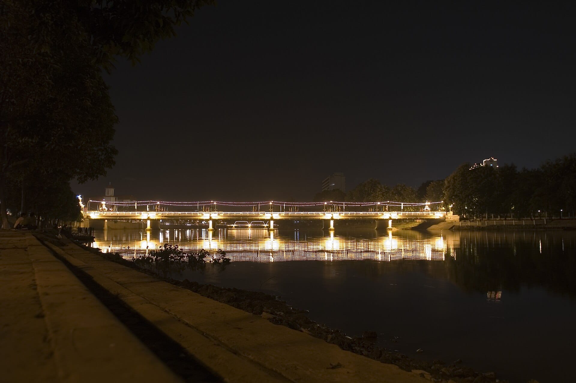
Evening
Dusk transforms the atmosphere significantly. By 5:30–6:30 p.m., the light turns gold and then pink over the river, and the pedestrian flow slows to something more leisurely. Locals come to watch the river rather than cross it. Food vendors appear near both bridge ends, selling grilled corn, fruit, and drinks from carts. The eastern approach to the bridge becomes noticeably more social, with people sitting on the low walls and concrete barriers that line the riverside promenade.
The stretch of riverfront just south of Nawarat is worth exploring after dusk. Several riverside restaurants and bars occupy renovated buildings here, and the Mae Ping River Cruises depart from piers within a short walk, offering a very different perspective on the same waterway.
What to See on and Around the Bridge
The bridge itself is roughly 100–150 meters long and wide enough for a separate pedestrian walkway alongside vehicle traffic. Concrete lamp posts line both sides, and there are small alcoves where locals stop to look out over the river. From the railing, you can watch long-tail boats and small vessels pass underneath, and during rainy season (July–October) the river level rises noticeably, sometimes dramatically, giving the bridge a different character entirely.
At the western end of the bridge, a short walk along the moat road leads toward Tha Phae Gate, the most recognizable landmark of the Old City. This makes Nawarat a natural starting or ending point for anyone exploring the Old City walls and gates on foot. The moat and its surrounding boulevard are pleasant at any time of day.
On the eastern side, the immediate neighborhood is a working commercial district with hardware shops, small restaurants, and a wholesale goods market that feeds the Old City economy. It is not polished for tourism, which gives it a more authentic texture than the heavily curated streets inside the moat. Walk two blocks east from the bridge and you are in a part of Chiang Mai most short-stay visitors never see.
Photography Guidance
Nawarat Bridge is a reliable location for river photography year-round, but the framing and conditions vary significantly by season. For a comprehensive approach to photographing Chiang Mai's architecture and landscapes, the Chiang Mai photography guide covers timing, locations, and equipment considerations in detail.
From the bridge walkway, facing south captures the river's wider downstream course with a lower density of buildings on the banks. Facing north gives the mountain backdrop in good weather. The bridge's lamp posts create natural leading lines in wide compositions. A wide-angle lens in the 16–24mm range on a full-frame camera (or equivalent) makes the most of the geometry. A small portable tripod is useful for dusk long-exposure shots of the river surface.
Note that traffic flows across the bridge continuously and pedestrians use the walkway on one side only. There is enough room to stop and shoot without blocking foot traffic, but it is not a location where you can set up a tripod in the middle of a lane. Work from the railing or the lamp post alcoves.
Practical Logistics
Nawarat Bridge is open at all hours. There is no entrance, no gate, and no official management. It is a public road bridge. Parking is not readily available nearby, and the surrounding streets are narrow and congested during morning and evening rush hours. Arriving on foot from the Old City, by bicycle, or by songthaew dropped on either approach road are the most practical options.
Accessibility on the bridge itself is moderate: the pedestrian walkway has no significant steps, but the approaches from both sides involve navigating busy street-level intersections. Visitors with mobility limitations should assess the crossing approach from the west side, off Tha Phae Road. For broader logistics about moving around the city, the getting around Chiang Mai guide covers songthaew routes, bicycle rental, and tuk-tuk use in detail.
There are no facilities directly on the bridge, no toilets, no water, no food. Both riverbanks have small vendors and cafés within a two-minute walk. The nearest concentration of restaurants and coffee shops is on the eastern bank, along Charoen Muang Road heading south.
Who Should Skip It
Travelers expecting a scenic heritage structure or a dedicated viewpoint with interpretation panels will be disappointed. This is a utility bridge in an urban setting. If your itinerary is short and you are prioritizing Chiang Mai's temple circuit or hill town excursions, Nawarat Bridge does not need to be a deliberate destination. It is better treated as something you cross on the way to somewhere else, at which point it becomes quietly meaningful rather than anticlimactic.
Visitors sensitive to traffic noise and exhaust fumes may also find lingering on the bridge unpleasant during peak hours. If what draws you to the riverfront is calm and greenery, Huay Tung Tao Lake and the parks north of the city offer a very different kind of outdoor experience.
Insider Tips
- Go before 7 a.m. on a weekday to see the bridge at its most genuinely local, with market vendors, monks, and school traffic all moving at once. The tourist layer is essentially absent at this hour.
- The small riverside promenade on the eastern bank just south of the bridge is a low-key local hangout spot in the evenings. Bring a drink from a nearby vendor and watch the river rather than crossing it.
- On clear mornings between November and February, Doi Suthep appears directly in line with the western approach road. Position yourself on the bridge facing west at sunrise for a city-and-mountain composition that requires no hiking.
- Rainy season (roughly July–October) brings the Ping River up significantly. After heavy rains, the river can rise to within a few meters of the bridge underside, and the current becomes fast and visibly powerful. It is one of the more dramatic natural things you can witness in central Chiang Mai without leaving pavement.
- If you are renting a bicycle, Nawarat is a natural turnaround point on a riverside cycling route. Head south along the western bank from the Old City, cross at Nawarat, and return north along the eastern bank for a 45-minute loop that covers both sides of the river.
Who Is Nawarat Bridge For?
- Photographers looking for authentic morning scenes with natural light and river reflections
- Urban explorers and slow travelers interested in everyday city life rather than curated experiences
- Cyclists and walkers building a riverside itinerary across both banks of the Ping River
- Repeat visitors to Chiang Mai who have covered the main temples and want a different perspective on the city
- Early risers who want to experience the city before the tourist infrastructure activates
Nearby Attractions
Other things to see while in Riverside (Ping River Area):
- Art in Paradise Chiang Mai (3D Art Museum)
Art in Paradise Chiang Mai is a large-format interactive 3D art museum located near the Riverside district. Visitors pose inside trompe-l'oeil paintings to create optical illusion photographs. It suits families, couples, and anyone looking for a lighthearted few hours indoors.
- Chiang Mai Night Bazaar
The Chiang Mai Night Bazaar is a sprawling commercial market district along Chang Khlan Road, drawing both tourists and locals with stalls selling handicrafts, clothing, street food, and souvenirs. It's well-organized and easy to navigate, but knowing what to expect prevents disappointment.
- Mae Ping River Cruises
The Mae Ping River has shaped Chiang Mai since the city's founding in 1296, and a river cruise remains one of the few ways to see the city from a genuinely different angle. Longboat and converted rice-barge tours depart from piers near Nawarat Bridge, passing riverside temples, colonial-era trading houses, and fruit orchards that survive within the city limits.
- Saturday Walking Street (Wua Lai Road)
Every Saturday evening, Wua Lai Road transforms into one of Chiang Mai's most atmospheric night markets. Known historically as the city's silversmith district, the street fills with handcrafted goods, northern Thai street food, and the glow of temple lanterns — all with noticeably fewer tourists than its Sunday counterpart.