Laguna de Guatavita: The Sacred Lake at the Heart of El Dorado
Laguna de Guatavita is a circular crater lake in the Cundinamarca highlands and one of Colombia's most significant sacred sites. Associated with the Muisca El Dorado ritual, it sits 75 km northeast of Bogotá inside a protected forest reserve managed by CAR. Access is by mandatory guided walk only, making every visit a slow, deliberate encounter with both Andean ecology and pre-Columbian history.
Quick Facts
- Location
- Between Sesquilé and Guatavita, Cundinamarca — approximately 75 km northeast of Bogotá
- Getting There
- By car via Autopista Norte toward Sesquilé; or bus from Terminal Norte to Guatavita, then local taxi to the park entrance
- Time Needed
- Half day minimum; guided circuit takes roughly 2 hours on-site, plus 1.5–2 hrs travel each way
- Cost
- Approx. 19,500–21,000 COP for Colombians; approx. 28,000 COP for foreign visitors (guide included in ticket price; verify current rates with CAR)
- Best for
- History lovers, hikers, photography, day-trippers from Bogotá, anyone tracing the El Dorado legend
What Laguna de Guatavita Actually Is
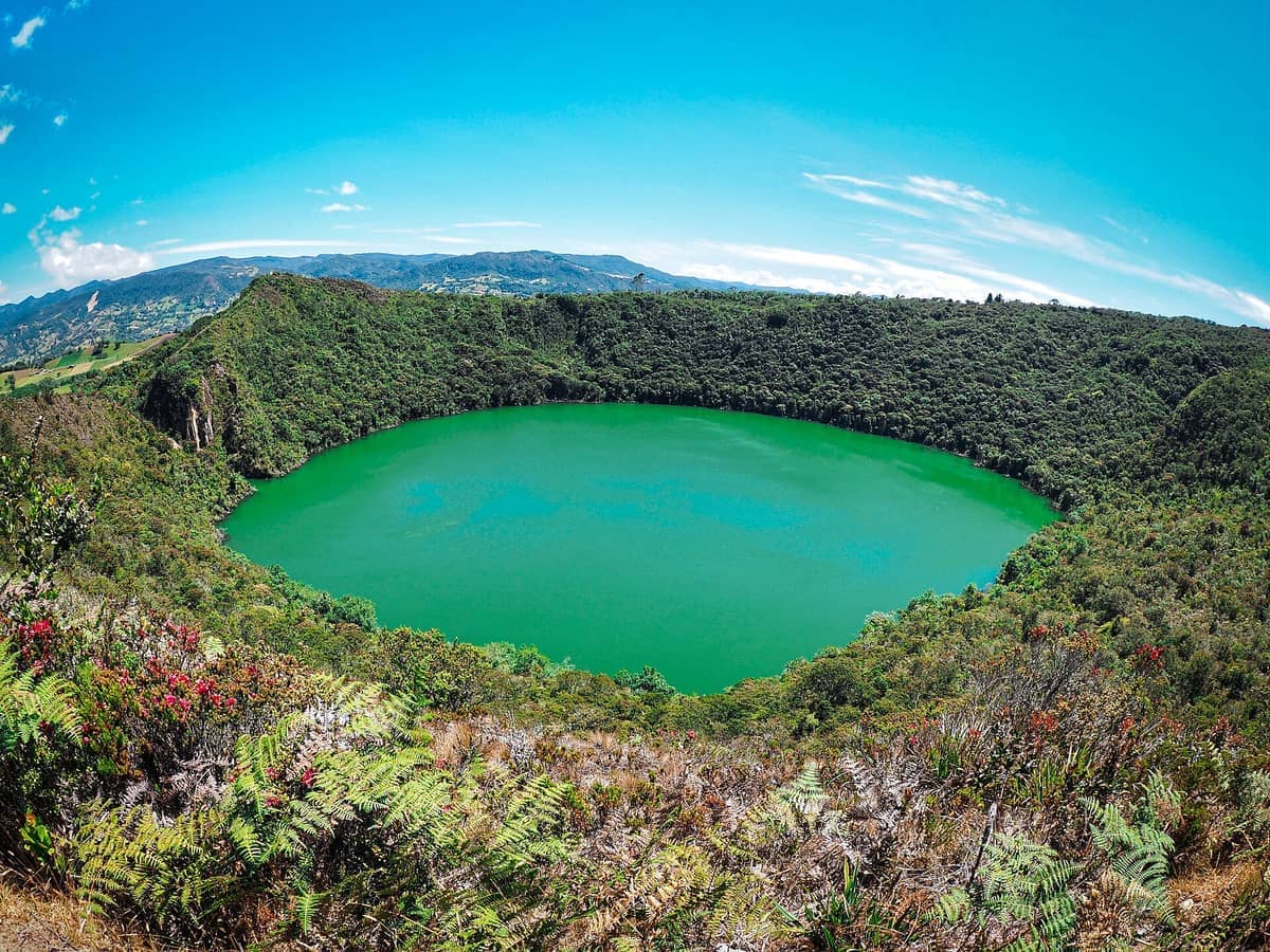
Laguna de Guatavita is not a typical scenic lake. It is a nearly perfect circular crater lake sitting at roughly 3,100 metres above sea level in the Eastern Andes of Cundinamarca, and it is protected under the designation Reserva Forestal Protectora Productora Laguna de Guatavita, managed by the Corporación Autónoma Regional de Cundinamarca (CAR). The circularity of the lake is striking from the rim: the water below is dark green, ringed by steep walls of cloud forest, and on clear days the surface reflects the sky like a disc of hammered copper.
For the Muisca people who inhabited the Cundinamarca and Boyacá highlands before Spanish colonisation, this lake was a sacred site of the highest order. It is directly associated with the El Dorado ritual, in which a newly anointed chief was covered from head to foot in gold dust and then, aboard a raft loaded with offerings of gold and emeralds, paddled to the centre of the lake. There, he submerged himself and the offerings into the water as an act of consecration. Word of this ritual, filtered through Indigenous accounts and Spanish imaginations, became the legend of El Dorado that sent European explorers across an entire continent.
The gold and emeralds thrown into Guatavita over generations were never fully recovered, despite multiple colonial-era and later drainage attempts. That history gives the place an undeniable weight. If you have already visited the Museo del Oro in Bogotá, where the famous Muisca raft figurine is displayed — a ritual object found at Pasca and interpreted as the Guatavita ceremony.
The Guided Circuit: What to Expect on the Walk
Entry is only possible as part of a guided group. The guide is mandatory and included in your ticket price, and groups depart at scheduled intervals throughout the day. This is not a restriction that diminishes the experience. The guides, most of whom speak Spanish with varying degrees of English, provide context that would be impossible to absorb from a sign alone: the significance of specific plants used in Muisca ceremonies, the history of the 16th-century drainage attempts, and the ecological work CAR has done to protect the watershed.
The circuit covers a trail of moderate difficulty that climbs to the rim of the crater and then follows the ridge before descending back to the entrance. Expect stepped paths, exposed tree roots, and sections of uneven ground that can be slippery in wet conditions. The ascent to the rim involves a sustained climb that visitors unfamiliar with altitude may find more demanding than expected. At 3,100 metres, the air is noticeably thinner than in Bogotá (itself at 2,640 m), and exertion hits harder. Take the pace slowly, drink water throughout, and do not underestimate the trail.
⚠️ What to skip
The path can become genuinely slippery after rain. Wear proper closed-toe shoes with grip — not sandals or fashion trainers. Light layers are essential: the trail starts in tree cover and opens onto the exposed crater rim, where temperatures and wind can drop quickly.
The payoff for the climb is a view that requires no interpretation. Standing on the rim of the crater looking down at the perfectly circular lake, with Andean cloud forest blanketing the slopes below and the Tominé reservoir glinting on the horizon, the landscape does most of the work. Allow time at the top rather than rushing through. The silence at the rim, broken only by wind and the occasional call of a mountain bird, is one of the more memorable things about the visit.
Tickets & tours
Hand-picked options from our booking partner. Prices are indicative; availability and final rates are confirmed when you complete your booking.
Guatavita and Zipaquira guided tour
From 115 €Instant confirmationFree cancellationCandelaria walking tour
From 35 €Instant confirmationFree cancellationCoffee farm guided tour
From 114 €Instant confirmationFree cancellationZipaquira Salt Cathedral guided tour
From 86 €Instant confirmationFree cancellation
How Light and Weather Transform the Experience
The site opens at 9:00 a.m. and closes at 4:00 p.m., with last entry around 3:00 p.m. Morning visits offer the best combination of clear skies, lower humidity, and cooler temperatures for the climb. In the Cundinamarca highlands, cloud and mist tend to build through the afternoon, and by early afternoon on rainy-season days the crater rim can be completely lost in low cloud. This is not always bad — mist gives the lake an appropriately ancient, atmospheric quality — but it does eliminate the panoramic view.
The dry seasons in the Bogotá region run from roughly December to March and June to August. Visiting during these windows maximises the chance of clear skies and a dry trail. The April to May and September to November rainy periods bring more frequent cloud cover and wetter paths, though visits are still possible and sometimes strikingly beautiful, particularly when mist sits low inside the crater.
For photographers, the golden hour light on the lake surface in the first hour after opening is worth the early start. The lake's dark green water absorbs and reflects light differently depending on cloud cover, and midday overcast conditions can actually produce even, flattering tones on the crater walls. For broader context on planning around Bogotá's seasons, the Bogotá weather and climate guide covers what to expect month by month.
Getting There from Bogotá
The lagoon lies approximately 75 km north of Bogotá, between the municipalities of Sesquilé and Guatavita. By private car or rideshare, the most direct route follows Autopista Norte north from the city, then turns toward Sesquilé and Guatavita, circling the Tominé reservoir. The last 8 km to the park entrance are on a signed road off the main circuit. Allow 1.5 to 2 hours each way depending on Bogotá traffic, which can be significant on weekday mornings. Parking is available at the park entrance.
By public transport, take a bus from Bogotá's Terminal de Transporte Norte to Guatavita town. From Guatavita, local transport or taxis cover the remaining distance to the reserve entrance. There is no direct public bus from Bogotá to the lagoon's entrance gate. Organised day tours from Bogotá, available through hostels and tour operators, are a common and practical option, particularly for first-time visitors who prefer the transport and guiding handled in one package.
💡 Local tip
If driving, fill up with fuel before leaving Bogotá. The road toward Sesquilé has limited service infrastructure. Also confirm the reserve is open before you go: CAR closes the site on Mondays (except when Monday is a public holiday, in which case it opens and closes on Tuesday) and on days when weather or maintenance requires it.
Historical Context: The El Dorado Legend and What Came After
The Muisca civilisation occupied much of the Cundinamarca and Boyacá highlands from at least the 9th century CE, developing complex trade networks, goldsmithing traditions, and ceremonial practices. Guatavita was among their most sacred lakes, associated with a serpent deity said to inhabit its depths. The El Dorado ritual was not a regular event but a singular coronation ceremony, though repeated offerings into the lake over generations accumulated an extraordinary quantity of gold on the lakebed.
Spanish colonisers were aware of the ritual within decades of conquest. In 1580, a merchant named Antonio de Sepúlveda organised the most significant drainage attempt, cutting a notch into the crater rim that partially lowered the water level and recovered some gold objects. The notch is still visible on the crater wall today. Later attempts in the 19th and early 20th centuries used industrial pumping, and the English company that undertook the 1898 effort recovered objects before the exposed lakebed mud hardened in the sun and rendered further excavation impossible. The Colombian government declared the lake a protected national monument in 1965, ending extraction attempts and eventually leading to its current status as a protected forest reserve.
The connection between Guatavita and the objects housed in Bogotá is direct. The Muisca raft figurine in the Museo del Oro — one of the most important pre-Columbian gold objects in existence — depicts the El Dorado ritual itself and was found in a cave at Pasca, south of Bogotá. Visiting both in the same trip creates a genuinely layered understanding of Muisca culture.
Practical Details and Limitations
Admission prices in recent CAR tariffs are approximately 19,500 COP for Colombian nationals and approximately 28,000 COP for foreign visitors, with lower rates for local residents (oriundos). These prices are set by CAR and are subject to change; verify current tariffs at the official CAR website before visiting. The guide is included in the admission fee and is not optional.
The trail is not suitable for visitors with significant mobility limitations. The terrain includes stairs, uneven packed-earth paths, and an exposed ridge section. Pets are not permitted inside the reserve. There are basic facilities at the entrance area, but the trail itself has no amenities. Bring water, sunscreen, and a windproof layer for the rim.
Who should reconsider this trip: visitors who are not comfortable with moderate hiking at altitude, those who require fully paved or wheelchair-accessible routes, and anyone on a very tight half-day schedule who has not factored in Bogotá's exit traffic. The journey time alone makes this a 6-to-7-hour commitment from central Bogotá. If altitude is a concern, read the Bogotá altitude guide before adding Guatavita — which sits even higher — to your itinerary.
Guatavita pairs well with the colonial town of Guatavita itself, which was purpose-built in the 1960s after the original town was flooded by the Tominé reservoir. It is an unusual place with whitewashed walls and a planned colonial aesthetic, worth a short walk if you are driving. For other rewarding day trips from the capital, the day trips from Bogotá guide covers the full range of options, including the Catedral de Sal de Zipaquirá, which can be combined with Guatavita in a single day by car.
Insider Tips
- Arrive at opening time (around 8:30–9:00 a.m.) to join the first guided group of the day. Groups are capped in size, and peak weekend slots fill up. Waiting for a later group on a busy Saturday can cost 45–60 minutes.
- The notch cut into the crater wall by Antonio de Sepúlveda's 1580 drainage attempt is visible from the rim. Ask your guide to point it out specifically — it is a concrete physical mark of the El Dorado obsession and easy to miss without direction.
- Bring a windproof layer specifically for the crater rim, even if the entrance area feels warm. The exposed ridge above the lake creates a channel effect, and temperatures at the rim can drop several degrees compared to the trailhead.
- If you are visiting during the rainy season, embrace the mist rather than fighting it. Low cloud inside the crater changes the experience but does not ruin it — the lake looks more dramatic under grey light than under flat midday sun.
- Combine the visit with a stop in Guatavita town for lunch before or after. The town's main square has simple restaurants serving traditional Cundinamarca food — ajiaco, changua, and grilled trout from the reservoir — and the setting is genuinely unusual given the town's planned colonial architecture.
Who Is Laguna de Guatavita For?
- Travellers who visited the Museo del Oro and want to see the physical source of the El Dorado ritual firsthand
- Hikers comfortable with moderate altitude terrain looking for a half-day trail with strong historical context
- Photographers seeking dramatic Andean crater landscapes, particularly in early morning light or misty conditions
- History and archaeology enthusiasts interested in pre-Columbian Muisca culture
- Day-trippers from Bogotá who want a complete change of scenery and pace from the urban environment
Nearby Attractions
Combine your visit with:
- Cascada La Chorrera
Cascada La Chorrera is Colombia's tallest waterfall, plunging approximately 590 metres through cloud forest on the road to Choachí, less than an hour east of Bogotá. The hike to reach it is a proper half-day commitment, not a gentle stroll, but the payoff is one of the most dramatic natural sights within day-trip distance of the capital.
- Catedral de Sal de Zipaquirá
Carved 180 meters beneath a working salt mine, the Catedral de Sal de Zipaquirá is one of South America's most extraordinary architectural achievements. This guide covers what to expect underground, how to get there from Bogotá, and whether the trip is worth your time.
- Jardín Botánico de Bogotá
The Jardín Botánico de Bogotá José Celestino Mutis is one of Colombia's most important living plant collections, spread across a flat, walkable campus that includes the striking Tropicario greenhouse complex. It is a calm, well-organized space that rewards visitors who enjoy botany, photography, and a break from the city's pace without leaving it.
- Paloquemao Market
Plaza de Mercado de Paloquemao is one of Bogotá's largest and most atmospheric covered markets, where wholesale vendors, home cooks, and curious travelers all share the same aisles. Open before dawn and free to enter, it offers an unfiltered look at Colombian food culture — from dozens of exotic native fruits to floor-to-ceiling towers of cut flowers.