Imgiebah Bay (Selmun Bay): Malta's Most Secluded Cove
Tucked into Malta's north-eastern coastline near Selmun, Imgiebah Bay is a small, sandy cove framed by sheer limestone cliffs. There are no facilities, no bus routes, and no easy road in — which is precisely why it stays quiet when every other beach in Mellieha is packed.
Quick Facts
- Location
- Selmun area, Mellieha, northern Malta (also known as Selmun Bay)
- Getting There
- No direct bus service. Approx. 1.5-hr walk or 30-min bike from Mellieha town centre. Car recommended; limited parking near cliff top.
- Time Needed
- 2–4 hours including travel, descent, and time at the beach
- Cost
- Free entry. Open 24/7 year-round.
- Best for
- Swimmers seeking solitude, snorkelers, hikers, and campers
What Imgiebah Bay Actually Is
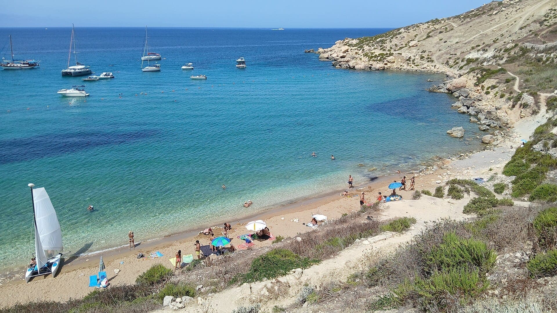
Mġiebaħ Bay, officially referred to by that Maltese spelling and widely known in English as Selmun Bay, sits on Malta's north-eastern coast within the limits of Mellieħa. It is a small pocket of pale sand hemmed in on three sides by vertical limestone cliffs that drop straight into extraordinarily clear water. The bay faces roughly northward and is sheltered by rugged limestone cliffs.
The honest description is this: Imgiebah Bay is a raw, undeveloped cove with no beach bars, no sunbed rental, no lifeguard, and no proper road to get there. What it offers instead is the kind of silence and cleanliness that Malta's more accessible beaches simply cannot provide on a July afternoon.
⚠️ What to skip
There are no facilities at Imgiebah Bay — no toilets, no shade structures, no food or water vendors. Bring everything you need, including drinking water, sun protection, and snacks. Plan to carry out all rubbish.
Getting There: The Route That Keeps It Quiet
The limited accessibility of Imgiebah Bay is not incidental — it is the entire reason the bay remains uncrowded. Finding the turn-off requires attention. Coming from the direction of Mellieħa, look for a sharp left turn before the main Mellieħa roundabout. The turn is marked by two columns with bamboo growth alongside, easy to miss at speed. From there, a narrow rural track winds past isolated farmhouses toward the cliff edge.
Parking is limited to a handful of spots near the clifftop. From there, a steep descent on a rough path brings you down to the beach. The path requires sure footing and good footwear — flip-flops are genuinely inadequate here. Budget around 10 to 15 minutes for the descent, and roughly the same coming back up, though the uphill return in summer heat is considerably harder. Take it slowly.
No Malta Public Transport bus serves this bay directly. Those without a car can cycle from Mellieħa town in approximately 30 minutes, or walk in around 1.5 hours. If you are combining this with other stops in the north, consider reading the guide to getting around Malta before planning your route. Ride-hailing apps including Bolt and Uber operate in Malta and can get you to the general Selmun area, but the final stretch of track may not be navigable by standard vehicles.
💡 Local tip
If you are driving, check that your vehicle has reasonable ground clearance for the final unpaved stretch. Low-slung rental cars can scrape on the rougher sections of the track.
Tickets & tours
Hand-picked options from our booking partner. Prices are indicative; availability and final rates are confirmed when you complete your booking.
City Sightseeing hop-on hop-off bus tour of Gozo
From 20 €Instant confirmationFree cancellationThe Malta Experience Audio-Visual Show and La Sacra Infermeria Tour
From 20 €Instant confirmationFree cancellationLuggage Storage in Malta
From 6 €Instant confirmationFree cancellation6-day heritage and attractions pass in Malta
From 80 €Instant confirmationFree cancellation
The Beach Itself: What You Will Find
The sand at Imgiebah Bay is pale and coarse rather than the fine powder of tropical brochures, but it is clean and considerable for a Maltese cove. The entry to the water is partly sandy and partly rocky, so water shoes are useful, especially near the edges of the bay where submerged limestone ledges are common. The water color ranges from bright turquoise in the shallows to deep cobalt further out, a result of the clarity and the limestone geology beneath.
Snorkeling directly off the rocks at either side of the bay is the main activity beyond swimming. The limestone formations host sea urchins, small fish, and occasional octopus — the kind of marine life that disappears when beaches get busy. On calm days, the water surface is almost entirely still by late morning, making underwater visibility excellent.
The bay is dog-friendly and permits both BBQs and camping, which makes it a particular draw for local Maltese families on weekends, especially in late spring and early autumn when the water is warm but the summer crowds have thinned. Arrive early on a Saturday or Sunday if you want to claim a quiet spot.
How the Bay Changes Through the Day
Early morning at Imgiebah Bay, roughly from sunrise until 9am, is almost always empty. The light hits the limestone cliffs at low angles, turning the rock face amber and gold. The water at this hour reflects the sky with a stillness that disappears once the afternoon wind picks up. If you have the option, this is the best time to photograph the bay — the cliffs glow, the water is glassy, and the descent feels cooler.
By midday in summer, the bay fills with whatever small crowd has made the effort to get there, typically a fraction of what any accessible beach would see. The northward orientation means the cliffs provide some natural shade in the afternoon as the sun moves west, which is a genuine advantage over south-facing coves. From around 3pm onward, the light softens and the water temperature is at its highest, making the late afternoon swim arguably the most comfortable of the day.
In winter and shoulder months, Imgiebah Bay can be completely deserted for hours at a stretch. The Mediterranean climate means even October and November bring swimming-temperature water, and the reduced UV index makes extended beach time far more comfortable. November through March brings a real chance of rough seas and sharp wind off the northern coast — check conditions before making the descent, as the path back up becomes slippery when wet.
⚠️ What to skip
The northern exposure that keeps Imgiebah Bay quieter also means it catches the Gregale wind — a strong north-easterly that can make the water rough and the cliff descent unpleasant. If winds above 20 km/h are forecast, consider postponing your visit.
Context: Mellieha's Coastline and What Surrounds the Bay
Imgiebah Bay sits within the broader Mellieħa coastal zone, which includes some of Malta's most visited beaches as well as several that remain largely unknown to visitors on short trips. Mellieha Bay to the south-west is the largest sandy beach on Malta and a complete contrast to Imgiebah: well-serviced, busy, and easily reached by bus. Knowing both exist helps you calibrate your expectations.
The Selmun area immediately above the bay is dominated by the Selmun Palace, a Baroque-era watchtower palace built in the 18th century by the Knights of St John and now a hotel. Its presence on the clifftop is visible from certain angles on the beach below, adding an unexpected layer of architectural history to what is otherwise a purely natural setting. For more on the Knights' influence across Malta, the Knights of Malta history guide provides useful background.
Mellieħa itself, a short drive inland, offers restaurants, supermarkets, and accommodation. It is a practical base for exploring the north of Malta, including the Red Tower on the ridge above Mellieħa and the ferry terminal for Comino and Gozo. If you are planning multiple days in the north, the 7-day Malta itinerary covers how to structure that well.
Who Should Think Twice Before Coming
Imgiebah Bay is not for everyone, and it is worth being direct about that. Anyone with limited mobility will find the cliff descent genuinely difficult. The path is uneven, steep, and has no handrails. Parents with very young children and buggies should plan for significant logistical effort. Those who want a comfortable beach day with shade umbrellas, food nearby, and easy water entry will be better served at Mellieha Bay or Golden Bay.
If your beach criteria include fine sand and calm, shallow water for children, Golden Bay on the west coast is the more practical choice and significantly easier to reach. Imgiebah rewards the self-sufficient traveler who brings what they need and does not require infrastructure.
Photography and Practical Kit
The visual draw of Imgiebah Bay is the interplay between the vertical limestone cliffs and the layered blue of the water. Wide-angle shots from the waterline looking back at the cliffs work especially well in early morning or late afternoon light. The contrast between the warm buff and grey of the rock and the cool turquoise below is the defining composition.
For snorkeling photography, a basic waterproof camera or housing is enough — the fish and rock formations are within arm's reach in the shallows. Drone use above Maltese beaches is regulated and requires a permit; check current Civil Aviation Directorate rules before flying.
- Bring at least 1.5 litres of water per person — more in summer
- Wear closed-toe shoes or sturdy sandals for the descent, switching to water shoes at the beach
- Pack a dry bag for valuables; there is nowhere to leave belongings safely
- Sunscreen is critical — the cliff faces reflect UV onto the beach
- A small portable speaker and a camping mat significantly improve a full-day stay
Insider Tips
- The sharpest left turn off the Mellieha approach road is easy to overshoot. If you find yourself entering Mellieha town, you have gone too far — turn around and look for the two stone columns on the right when re-approaching from the town side.
- Local families often camp overnight at Imgiebah Bay on warm weekends, particularly around Maltese public holidays. If you want the bay to yourself, a weekday arrival before 9am is the most reliable strategy.
- The rocky shelves on the right side of the bay (facing the water) are the best snorkeling area. Depths drop gradually and the formations are more complex than the sandy centre. Give sea urchins on the rocks a wide berth.
- Because the bay faces north, it receives direct sunlight through the morning and into early afternoon but loses it progressively as the sun moves west. Plan your arrival time based on whether you want full sun or natural shade.
- On the cliff descent, the final section is the steepest. Coming back up with wet feet and a full beach bag in July heat is harder than it looks on the way down. Give yourself more time and energy for the return than you think you will need.
Who Is Imgiebah Bay For?
- Independent travelers and hikers who want a Maltese beach without the infrastructure crowds
- Snorkelers looking for clear, undisturbed water and accessible marine life
- Couples after a genuinely private beach day away from resort areas
- Campers and BBQ groups comfortable with pack-in, pack-out rules
- Photographers seeking dramatic limestone cliff compositions without other visitors in frame
Nearby Attractions
Other things to see while in Mellieħa:
- Armier Bay
Armier Bay sits at Malta's northern tip, split between a wide family-friendly beach and a smaller, rockier cove ideal for snorkeling. The water is clear, the pace is slow, and the views reach across to Comino and Gozo. It rewards visitors who seek something more local than the island's main tourist beaches.
- Sanctuary of Our Lady of Mellieħa
The Sanctuary of Our Lady of Mellieħa is Malta's oldest Marian shrine, built around a natural cave where a Byzantine-style fresco of the Virgin Mary has drawn pilgrims for centuries. Free to enter and steeped in nearly two thousand years of layered history, it sits above Mellieħa Bay and rewards visitors with both spiritual atmosphere and architectural beauty.
- Golden Bay
Golden Bay is widely considered Malta's best sandy beach, tucked into the northwest coastline near Mellieħa. With Blue Flag water quality, summer lifeguards, and a dramatic cliffside backdrop, it earns its reputation — though its relative fame means it fills up fast on summer weekends.
- Mellieħa Bay (Għadira)
Mellieħa Bay, also known as Għadira Bay, stretches over a kilometre along Malta's northwestern coast and earns its reputation as the island's finest sandy beach. Shallow, calm waters and a Blue Flag certification make it the go-to destination for families. Right next door, the Għadira Nature Reserve adds a surprising layer of ecological interest to what could otherwise be a straightforward beach visit.