Great Barrier Island (Aotea): Auckland's Last True Wilderness
Roughly 90 km from Auckland's waterfront, Aotea Great Barrier Island feels like a different country. No traffic lights, no supermarket chains, no mobile coverage across most of the island. What you get instead: a Gold-rated Dark Sky Sanctuary, forest tracks through ancient kauri, surf beaches with almost no one on them, and a pace of life that makes a weekend feel like a week.
Quick Facts
- Location
- Hauraki Gulf, Hauraki Gulf, approx. 100 km northeast of Auckland city centre
- Getting There
- Ferry (SeaLink, approx. 4.5–5 hrs from Auckland) or flight (approx. 30 min); no regular island public transport
- Time Needed
- Minimum 2 nights; 3–5 nights recommended to do it justice
- Cost
- No island admission fee; ferry and flight fares vary by operator and season — verify before booking
- Best for
- Hikers, stargazers, surfers, families seeking digital detox, nature photographers
- Official website
- www.greatbarrier.co.nz
What Aotea Great Barrier Island Actually Is
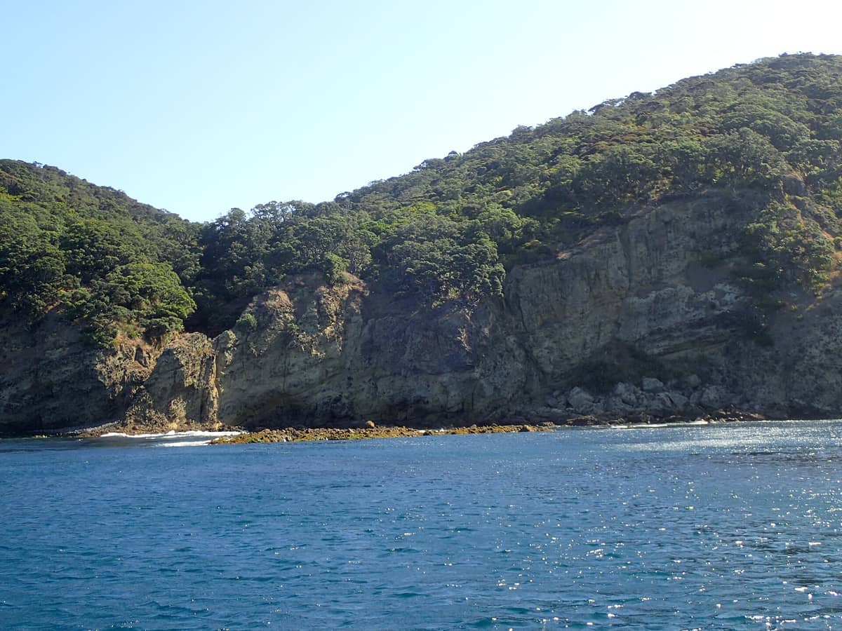
Aotea Great Barrier Island sits at the outer edge of the Hauraki Gulf, separated from the Coromandel Peninsula by the Colville Channel and from urban Auckland by roughly 100 km of open water. It is the sixth-largest island in New Zealand and, despite sitting within the Auckland region, retains a character that has almost nothing to do with the city. There are no traffic lights on the island, no reticulated water supply, no widespread mobile coverage, and no mains electricity grid. Residents rely on rainwater tanks, solar panels, and generators. Visitors who arrive expecting Waiheke-style boutique convenience will be surprised.
The island's dual name reflects its layered identity. In te reo Māori it is Aotea, meaning white cloud or white sail, a name with deep ancestral significance to the local Ngāti Rehua Ngātiwai ki Aotea iwi, the mana whenua of the island. The English name, Great Barrier Island, refers to the island's function as a natural barrier reef protecting the inner Hauraki Gulf from the open Pacific Ocean.
ℹ️ Good to know
Planning context: Aotea is not a ticketed attraction with set opening hours. It is an inhabited island and conservation area. Most practical logistics, including ferry schedules, accommodation availability, and track conditions, should be verified directly with operators before you travel.
Getting There: Ferry vs. Flight
Most visitors arrive by SeaLink ferry, which departs from Auckland City's Hamer Street terminal and takes approximately 4.5 to 5 hours, docking at Tryphena on the island's southern tip (the Tryphena terminal is at 4 Shoal Bay Road). The crossing can be rough in southerly weather, and open-ocean swells between the gulf and the outer islands are significantly different from the sheltered harbour crossings most ferry travellers in Auckland are used to. If you are prone to seasickness, plan accordingly or take a sea-sickness remedy well before departure.
The faster alternative is to fly. Flights from Auckland operate in around 30 minutes, landing at Claris Airport in the island's central plateau. Several operators run scheduled and charter flights; check current availability and prices through the official visitor site or Auckland Airport's listings. For a first visit, flying in and ferrying back (or vice versa) gives you both the aerial view of the island's topography and the more immersive sea approach.
⚠️ What to skip
There is no regular public transport anywhere on the island. If you arrive without a vehicle, you'll need to arrange a local shuttle or taxi in advance, or hire a vehicle on the island. Options are limited, especially in low season, so book ahead.
For broader context on reaching the Hauraki Gulf's island destinations, the Hauraki Gulf islands guide covers access routes, travel times, and planning tips for the gulf as a whole.
Tickets & tours
Live prices and dates from our booking partner. If you book, we may earn a commission at no extra cost to you.
Luggage Storage in Auckland
From 5 €Instant confirmationFree cancellationNew Zealand West Coast discovery tour
From 100 €Instant confirmationFree cancellation13,000ft skydiving experience in Auckland
From 195 €Instant confirmationFree cancellationDiscover Auckland City Tour
From 88 €Instant confirmationFree cancellation
The Landscape: What You Are Looking At
Aotea's terrain is rugged in a way that photographs rarely convey. The Hirakimata (Mount Hobson) massif rises to 621 metres at the island's centre, draped in regenerating native forest including kauri, rimu, and kahikatea. From the summit on a clear morning, the view sweeps south across the Hauraki Gulf toward Auckland's skyline and north toward the outer gulf. The walk up is one of the island's signature tracks and involves a combination of well-formed path and boardwalk sections through kauri forest.
The western coast is sheltered, with calm bays and mudflats at low tide. The east coast is entirely different: exposed surf beaches running for kilometres, backed by dunes and occasionally pounded by Pacific swells. Medlands Beach, on the east coast, is consistently cited by those who know the island as one of the most beautiful surf beaches in the greater Auckland region, and it is rarely crowded even in summer. The contrast between the two coasts in a single day's driving or cycling is one of Aotea's defining experiences.
Aotea's coastal character is distinct from the more accessible western beaches. For comparison, the Auckland west coast beaches guide covers Piha, Muriwai, and Karekare for travellers who want wild surf beaches reachable in a day trip.
The Historical Layer: Kauri, Copper, and Whaling
Aotea has a layered human history that rewards curiosity. Māori settlement on the island is long-standing, and the island features pā sites and other archaeological features, some of which are protected. The arrival of European settlers in the 19th century brought successive waves of extraction. Kauri logging stripped much of the island's ancient forest during the 1800s. The kauri dams, enormous wooden structures built to sluice logs down stream valleys, are among the most striking remnants of this era, several of which are preserved and can be visited on foot today.
Copper mining is a lesser-known chapter. Copper was discovered at Miners Head in 1841, and mine workings were established there the following year. The historic coppermine's main chamber is a remarkable space: 75 metres long, 25 metres wide, and 50 metres high, dimensions that are genuinely surprising when you encounter them in a remote coastal landscape. The Department of Conservation maintains information on these historic workings, and visiting them adds a layer of industrial archaeology to what might otherwise feel like a purely natural experience.
Whaling also touched the island. Tryphena Harbour, the main arrival point for ferry visitors, takes its name from a whaling vessel that sheltered there. These layers of history are not prominently signed across the island, which means the attentive visitor who reads ahead will get far more from a visit than one who arrives cold.
Dark Skies, Silence, and the Night Experience
Aotea holds Dark Sky Sanctuary status from the International Dark-Sky Association, one of only a small number of places in the world to receive this designation. With no mains electricity grid and minimal artificial light pollution, the island's night sky on a clear, moonless night is extraordinary by any standard. The Milky Way is visible to the naked eye as a dense, textured band of light rather than the faint smear most urban and suburban visitors are accustomed to seeing.
The practical implication is that a clear night on Aotea is worth planning around. Accommodation operators are generally aware of the dark sky asset and some offer telescope access or guided stargazing. The southern sky from New Zealand's latitude offers visibility of the Magellanic Clouds and the Southern Cross at angles that northern hemisphere visitors find disorienting and spectacular in equal measure. Even without a telescope or guide, walking onto a beach well away from settlement lights on a clear autumn or winter night is an experience that is genuinely difficult to replicate closer to Auckland.
Hiking, Tracks, and How to Use Your Time
The Department of Conservation manages a significant network of walking tracks across Aotea. The Hirakimata Track to the island's summit is the most popular multi-hour walk, typically requiring a full day return from the trailhead. The kauri forests along this route are mature and quiet in a way that the more accessible Waitākere Ranges, closer to Auckland, no longer fully are due to kauri dieback disease. Aotea's kauri forests are subject to their own strict biosecurity protocols: all footwear and equipment must be cleaned and dried before entering kauri areas. There are cleaning stations at trailheads, and compliance is not optional.
For context on what Auckland-region hiking generally involves in terms of preparation and expectations, the guide to the best hikes in Auckland is a useful reference before committing to Aotea's more remote tracks.
Beyond the summit, shorter tracks connect beaches, historic sites, and viewpoints across the island. The Kaitoke Hot Springs track, a flat and relatively easy walk, leads to geothermal pools in a stream bed where warm water seeps up through gravel, a genuinely unusual experience in an Auckland-region context. These are not developed spa pools; they are natural thermal seeps, and the temperature varies by season and rainfall. Arrive with appropriate expectations and you will find them memorable.
💡 Local tip
Kauri dieback biosecurity: Before entering any kauri forest area on Aotea, clean all footwear and gear thoroughly at designated stations. This is a legal and ecological requirement, not a suggestion. Phytophthora agathidicida, the pathogen that causes kauri dieback, is spread through soil on boots.
Practical Realities: What to Know Before You Go
Aotea is not set up for impulse visits. Accommodation is limited, especially quality self-contained options, and books up quickly in the summer months of December through February and around long weekends. Plan a minimum of two nights; three to five nights is a more realistic window for seeing the island's variety without rushing. A single overnight stay is technically possible but tends to feel incomplete given the time involved in just getting there.
Mobile coverage is minimal to nonexistent across most of the island. This is a feature as much as a limitation, but it means you cannot rely on Google Maps, online bookings, or real-time transport information once you land. Download offline maps before departure, confirm all bookings in advance, and carry cash since card payment is not universally available. Fuel is available on the island but is more expensive than in Auckland, so plan if you are hiring a vehicle.
The island's weather is maritime and changeable. Summer (December to February) brings the most settled conditions and warmest sea temperatures, but also the most visitors relative to capacity. Autumn (March to May) sees fewer people and often stable weather. Winter crossings by ferry can be rough and should be checked against the forecast.
If you're weighing Aotea against other Hauraki Gulf destinations for a shorter trip, a Waiheke Island day trip is a very different, more accessible experience that suits visitors with less time to commit.
Who Should Skip This One
Aotea is not for everyone, and there is no point softening that. Travellers with only a day or two in Auckland will spend almost their entire time in transit. Those who rely on constant connectivity, need reliable wheelchair-accessible infrastructure, or are uncomfortable with basic facilities across remote areas will find the island poorly suited to their needs. The accommodation ranges from DOC huts and campsites to mid-range lodges, but there are no large hotels, and options for travellers with significant mobility requirements are not well documented in official sources.
The experience also requires some tolerance for uncertainty: ferry services can be affected by weather, track conditions change seasonally, and the island's limited commercial infrastructure means that things like restaurants keeping consistent hours should not be assumed. If you need the security of a predictable schedule, Aotea will test you.
Insider Tips
- Book accommodation and ferry or flight tickets well in advance for the December–February period and any New Zealand public holiday weekends. Capacity is genuinely limited and the island does not have overflow options.
- If you want the dark sky experience, plan around the lunar calendar. A full moon significantly reduces the impact of Aotea's dark sky status; a new moon on a cloudless night is when the designation actually delivers what it promises.
- The Kaitoke Hot Springs are best visited in the morning before the track gets foot traffic. Water temperature in the thermal pools varies with rainfall and season, so check recent visitor reports before treating it as a guaranteed highlight.
- Download NZ Topo Map (the app) with offline maps of Aotea before you leave Auckland. Cellular navigation will not work across much of the island and the track network is more complex than a simple summit and return.
- When visiting the historic coppermine at Miners Head, combine it with the coastal walk for context. The scale of the main chamber (75 m long, 25 m wide, 50 m high) is genuinely unexpected and worth seeing without rushing.
Who Is Great Barrier Island (Aotea) For?
- Multi-day hikers who want serious trails without the crowds of more accessible parks
- Stargazers and astrophotographers seeking genuine low-light-pollution skies within New Zealand
- Families planning a digital-detox trip with children old enough to handle remote-area travel
- Surfers and coastal walkers drawn to empty east-coast beaches
- Travellers interested in New Zealand's industrial and Māori heritage in a landscape context
Nearby Attractions
Combine your visit with:
- Auckland Botanic Gardens
Spread across 64 hectares in Manurewa, the Auckland Botanic Gardens offer free entry every day of the year, with themed garden collections, 10 hectares of native forest, and a visitor centre on site. It sits south of the city centre and rewards a longer visit than most people initially plan for.
- Auckland Zoo
Auckland Zoo has been part of the city's fabric since 1922, sitting in the Western Springs precinct with a collection that spans native New Zealand wildlife and international species. This guide covers everything from ticket prices and transit options to the best time of day to arrive and which exhibits deliver the most.
- Bastion Point (Takaparawhau)
Takaparawhau, known widely as Bastion Point, is a grassy headland in Ōrākei where Māori history, colonial conflict, and sweeping Waitematā Harbour views converge. It costs nothing to visit, carries centuries of significance, and rewards visitors who take time to understand what they are standing on.
- Bethells Beach (Te Henga)
Bethells Beach, officially Te Henga (Bethells Beach), is a raw, dramatic stretch of black-sand coastline about 45 minutes west of central Auckland. With rolling dunes, a freshwater lagoon, strong surf, and zero phone coverage, it delivers a genuine wilderness experience rare for a city of 1.6 million people.
Planning a trip? Discover personalized activities with the Nomado app.