Fjällgatan: Stockholm's Most Rewarding Viewpoint Street
Perched on the Stigberget cliff in Södermalm, Fjällgatan is a cobbled 18th-century street that doubles as one of Stockholm's finest free viewpoints. The panorama sweeps across Gamla Stan, Skeppsholmen, and Djurgården — and the street itself, lined with preserved wooden houses, is worth the uphill walk on its own terms.
Quick Facts
- Location
- Fjällgatan, 11628 Stockholm (Södermalm)
- Getting There
- Metro: Medborgarplatsen (Green line), then ~10 min walk east via Folkungagatan and up Erstagatan
- Time Needed
- 30–60 minutes for the street and viewpoint; longer if you linger at sunrise or sunset
- Cost
- Free — open 24 hours, no ticket required
- Best for
- Panoramic city views, 18th-century architecture, photography, and quiet walks away from tourist crowds
- Official website
- www.visitstockholm.com/o/fjallgatan
What Fjällgatan Actually Is
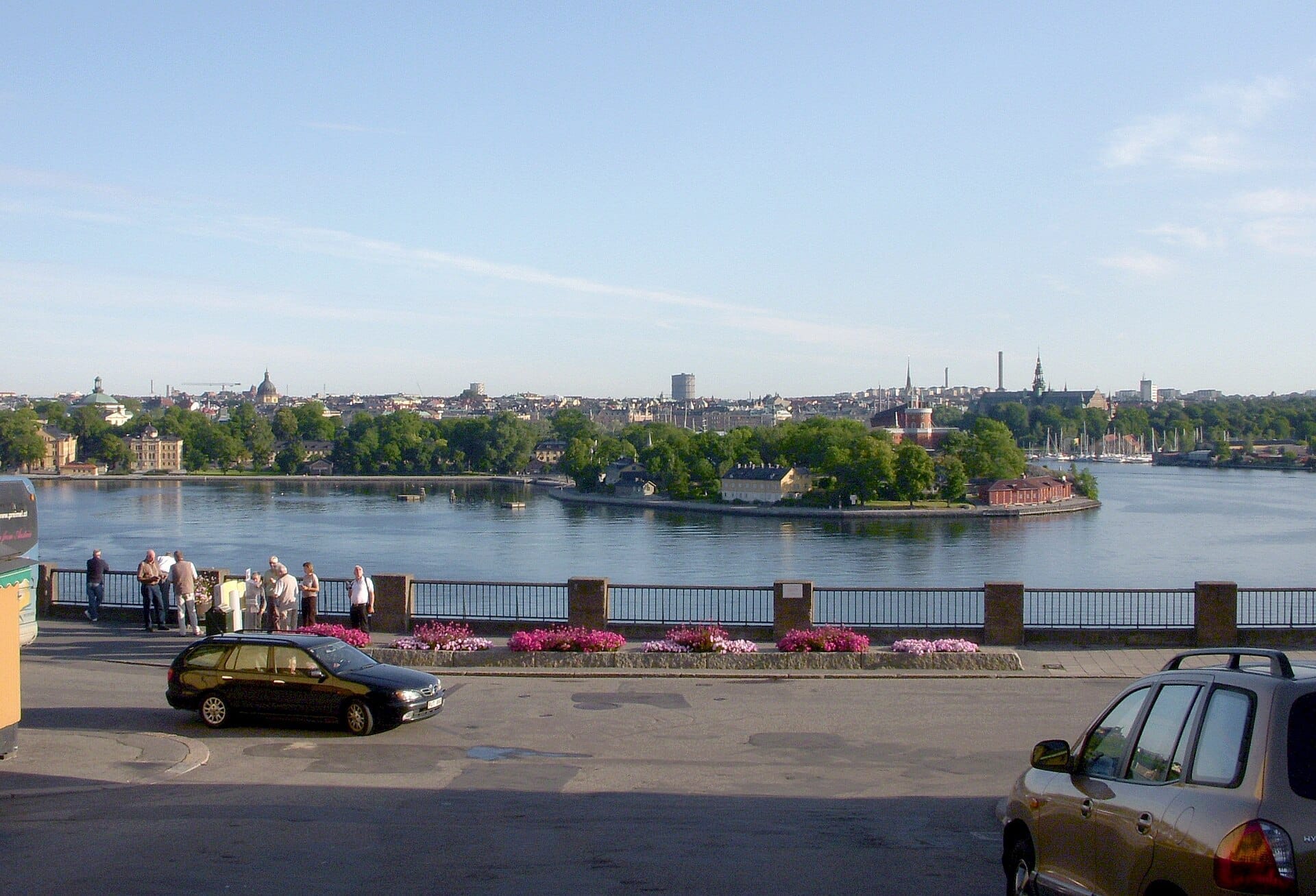
Fjällgatan is a historic street running along the northern edge of Stigberget, a cliff face on Södermalm; the street lies approximately 27.8 metres above the waters of Saltsjön below. From this ledge, the street looks directly north over some of the most concentrated historic scenery in Stockholm: Gamla Stan's copper rooftops, the spire of Storkyrkan, the green dome of the German Church, the low silhouette of Skeppsholmen, and the wooded shoreline of Djurgården stretching east.
Unlike purpose-built observation platforms or paid tower viewpoints, Fjällgatan is simply a street — one you walk along, stop on, and leave when you're ready. The wooden and stone houses lining it date largely from the 18th century and remain in residential use today. The combination of a lived-in historic streetscape and a genuinely commanding view makes it one of the more complete experiences Södermalm offers.
For context on how this fits into Södermalm's geography and character, the Södermalm neighborhood guide covers the broader island, including how to navigate between its main viewpoints and attractions.
History: From Gallows Hill to Fjällgatan
The area’s darker past is tied to its earlier role as an execution site: Stigberget was associated with gallows during Stockholm's medieval and early modern period, and its elevated, visible position made it a logical place for public executions. Executions on city outcrops were a common feature of pre-modern Scandinavian urban life, and the elevated, visible position of this particular cliff made it a logical site.
The current name, Fjällgatan, was formalized in the late 19th century as part of a broader revision of Stockholm's street names. The name itself roughly translates to "Mountain Street" or "Cliff Street," which is an accurate description of its terrain if not especially poetic. The name itself roughly translates to 'Mountain Street' or 'Cliff Street,' which is an accurate description of its terrain if not especially poetic.
The wooden houses that line the street survived the widespread urban renewal that demolished much of working-class Södermalm in the 20th century. Their survival is partly due to the difficult terrain — the slope made large-scale redevelopment impractical — and partly due to growing preservation awareness in Stockholm from the 1960s onward. Today they stand as a relatively intact example of what modest Stockholm residential architecture looked like before industrialization.
Visitors with a deeper interest in Stockholm's medieval layers might pair Fjällgatan with a walk through Gamla Stan, visible from the viewpoint below, where many of the city's oldest standing structures are concentrated.
Tickets & tours
Live prices and dates from our booking partner. If you book, we may earn a commission at no extra cost to you.
2-hour archipelago tour on a RIB speedboat
From 122 €Instant confirmationFree cancellationHaunted Stockholm exploration game and tour
From 12 €Instant confirmationFree cancellationFotografiska Stockholm entrance tickets
From 0 €Instant confirmationFree cancellationStockholm: Nature Reserve Hiking Tour with Campfire Lunch
From 102 €Instant confirmationFree cancellation
The View: What You're Actually Looking At
Standing at the railing along Fjällgatan's north edge, the panorama unfolds in a wide arc. Directly below, the waterway of Saltsjön separates Södermalm from the smaller islands to the north. Gamla Stan sits slightly to the left (west), its dense roofscape punctuated by church towers and the Royal Palace's long facade. Skeppsholmen and Kastellholmen occupy the middle distance, with their former naval buildings now housing museums and cultural institutions.
To the east, Djurgården's tree line forms a green border against the water. On clear days, particularly in the low-angle light of autumn or early spring, the view has a layered, almost graphic quality — the islands appearing as flat planes stacked behind one another. In summer, when Stockholm's long evening light stays warm well past 9 p.m., the scene shifts from daytime clarity to a softer, amber-toned panorama that photographers specifically target.
💡 Local tip
For the best photographs, arrive either in the hour after sunrise or in the 90 minutes before sunset. Midday light in summer is harsh and flattens the view. In winter, the low sun stays near the horizon all day, creating good photographic conditions from mid-morning onward.
The views from Fjällgatan are often compared to those from Monteliusvägen on the western side of Södermalm. They're different in character: Fjällgatan frames Gamla Stan and the eastern islands, while Monteliusvägen looks west toward Kungsholmen and City Hall. Both are free; Fjällgatan tends to be less discovered.
What It Feels Like to Visit: Hour by Hour
Early morning, Fjällgatan is almost always quiet. The residents who live in the wooden houses along the street are going about their routines — bins out, a bicycle being unlocked, the occasional dog walk. The sounds are the sounds of a residential neighborhood, not a tourist attraction: traffic from below, pigeons, the distant clang of a tram on Ringvägen. The air carries the faint saltiness of the water far below.
By mid-morning in peak summer, the first visitors arrive, typically in pairs or small groups. The street never becomes densely crowded in the way that Gamla Stan's lanes do, but it does see a steady flow of visitors between roughly 10 a.m. and 4 p.m. on summer weekends. Even at its busiest, the atmosphere remains calm — there's no ticket queue, no audio tour crowd, nothing to cause a bottleneck.
Evenings in summer are genuinely special. Stockholm's northern latitude means the light doesn't fade until close to 10 p.m. in June and July, and the viewpoint takes on a different quality as the city below shifts from active daytime to a quieter, warmer register. A small number of visitors specifically come at this hour — often locals walking after dinner rather than tourists on a schedule.
Winter visits are underrated. The street is slippery after ice or snow, which requires care on the ascent (see accessibility note below), but the view on a clear winter day, with low golden light hitting the water and Gamla Stan's pale facades, is arguably more striking than the green-season version. Crowds are minimal.
⚠️ What to skip
The uphill approach via Erstagatan is steep. Visitors with limited mobility, or those using strollers or wheelchairs, will find the gradient difficult. There is no elevator or ramp access to the viewpoint level. In icy conditions, the cobbled street itself can also be slippery — wear appropriate footwear in winter.
Getting There: The Practical Details
The most straightforward route from central Stockholm is by metro to Medborgarplatsen station, served by the Green line. From the station, walk east along Folkungagatan, then turn right (south) onto Erstagatan and follow the road uphill. The ascent takes roughly 10 minutes at a moderate pace and involves a noticeable gradient in the final section. The effort is modest for most walkers.
Alternatively, several bus routes serve the Södermalm streets below the cliff, and the walk from Slussen — the major transit hub connecting Södermalm to Gamla Stan — takes around 15 minutes on foot heading east and then uphill. Slussen is particularly convenient if you're arriving from Gamla Stan or the central city.
If you're planning a full day in Södermalm, the guide to getting around Stockholm covers SL transit options, including day passes that make it easy to combine Fjällgatan with other parts of the island without paying per journey.
Combining Fjällgatan with the Surrounding Area
Fjällgatan works best as part of a longer walk through Södermalm rather than as a standalone destination. Coming up from Medborgarplatsen, you pass through one of the island's more authentic residential stretches. On the way back down, a detour west along the cliff toward Katarinaberget brings you past Mosebacke and eventually down toward Slussen.
The Södermalm streets south of the viewpoint connect to the SoFo area, the grid of blocks around Nytorget known for independent shops and cafes. SoFo is a good place to find coffee before or after the climb.
For those treating Fjällgatan as part of a broader city viewpoints itinerary, it pairs logically with Skinnarviksberget, Södermalm's highest natural point, which is a 20-minute walk west and offers an even wider (if less architecturally framed) panorama.
A full overview of Stockholm's best vantage points — including which are free, which require tickets, and which suit different times of day — is covered in the best views in Stockholm guide.
Photography at Fjällgatan
The viewpoint is consistently popular with photographers because the railing along the cliff edge gives a clean, unobstructed sightline north across the water. There are no power lines cutting through the frame in the primary direction, and the composition — water in the foreground, Gamla Stan in the middle distance, sky above — works with both wide-angle and telephoto focal lengths.
A wide lens (24–35mm equivalent on full frame) captures the full arc from Gamla Stan west to Djurgården east. A longer focal length (85–135mm) isolates the Royal Palace facade or compresses the layers of islands into a tighter, more graphic image. The railing itself is at roughly waist height, which allows shooting over it without obstruction.
ℹ️ Good to know
The street faces north, which means it is in partial shade during parts of the morning in summer. For shots that include the street's wooden house facades alongside the view, afternoon light (roughly 2–5 p.m.) wraps around from the west and catches the house fronts more evenly.
Insider Tips
- The benches along the railing fill up quickly on warm summer evenings. If you want a seat to watch the light change, arrive by 7:30 p.m. on weekends in June and July.
- Walk the full length of the street rather than just stopping at the main viewpoint section. The eastern end, closer to Erstaberget, is quieter and has some of the best-preserved house facades with less foot traffic in front of them.
- Autumn, particularly October, brings low mist over the water in the mornings that can create an unusually atmospheric view — the islands appearing to float above a white layer. It clears quickly, so an early start is necessary.
- If you're coming from Slussen on foot, the climb via Katarinavägen and the steps near Mosebacke is a more interesting route than the Erstagatan approach, passing older residential architecture and fewer roads.
- The street itself is residential — people live in these houses year-round. Keep noise to a minimum in early mornings and late evenings, particularly on weekdays.
Who Is Fjällgatan For?
- Photographers looking for a free, unobstructed panoramic viewpoint at different times of day
- Travelers who want to understand Stockholm's geography — seeing the islands from above makes the city's layout suddenly legible
- Architecture and urban history enthusiasts interested in intact 18th-century residential streetscapes
- Visitors planning a half-day walk through Södermalm who want a natural high point to anchor the route
- Winter visitors — the low crowds and low sun angle make this a better cold-weather experience than many Stockholm attractions
Nearby Attractions
Other things to see while in Södermalm:
- Fotografiska
Housed in a 1910 red-brick customs building on Södermalm's waterfront, Fotografiska is one of Europe's most serious photography museums. With rotating major exhibitions, a respected restaurant, and museum doors open until 23:00 every day, it works equally well as an afternoon cultural stop or an evening out.
- Katarina Elevator
The Katarina Elevator (Katarinahissen) is a public passenger lift at Slussen that carries you 38 metres up to a walkway on the Södermalm cliff edge, with wide views over Gamla Stan, the Riddarfjärden inlet, and Stockholm's island geography. It reopened in October 2023 after years of renovation, is currently free to ride when operating, and the journey itself takes under 30 seconds.
- Monteliusvägen
Perched about 25 metres above Söder Mälarstrand on northern Södermalm, Monteliusvägen is a 416-metre pedestrian promenade delivering unobstructed panoramas across Lake Mälaren, Gamla Stan, and Stockholm City Hall. Entry is free, the path is open around the clock, and the views change dramatically with the light and the season.
- Skinnarviksberget
Perched 53 metres above sea level on Södermalm, Skinnarviksberget is Stockholm's highest natural point within the inner city. It costs nothing to visit, is freely accessible at all hours (with an alcohol ban in the park between midnight and 7am), and delivers one of the most unobstructed panoramas in the Swedish capital, taking in the City Hall tower, Lake Mälaren, and the rooftops of Gamla Stan.
Planning a trip? Discover personalized activities with the Nomado app.