Monteliusvägen: Stockholm's Best Free Viewpoint Walk
Perched about 25 metres above Söder Mälarstrand on northern Södermalm, Monteliusvägen is a 416-metre pedestrian promenade delivering unobstructed panoramas across Lake Mälaren, Gamla Stan, and Stockholm City Hall. Entry is free, the path is open around the clock, and the views change dramatically with the light and the season.
Quick Facts
- Location
- Monteliusvägen, 118 25 Stockholm (northern Södermalm, Mariaberget)
- Getting There
- Slussen metro (~300 m uphill via Klevgränd) or Mariatorget metro (~5 min walk)
- Time Needed
- 30–60 minutes for a leisurely walk; longer if you linger at the benches
- Cost
- Free — no tickets, no booking
- Best for
- Panoramic photography, sunrise and sunset walks, romantic strolls
- Official website
- www.visitstockholm.com/o/monteliusvagen
What Is Monteliusvägen?
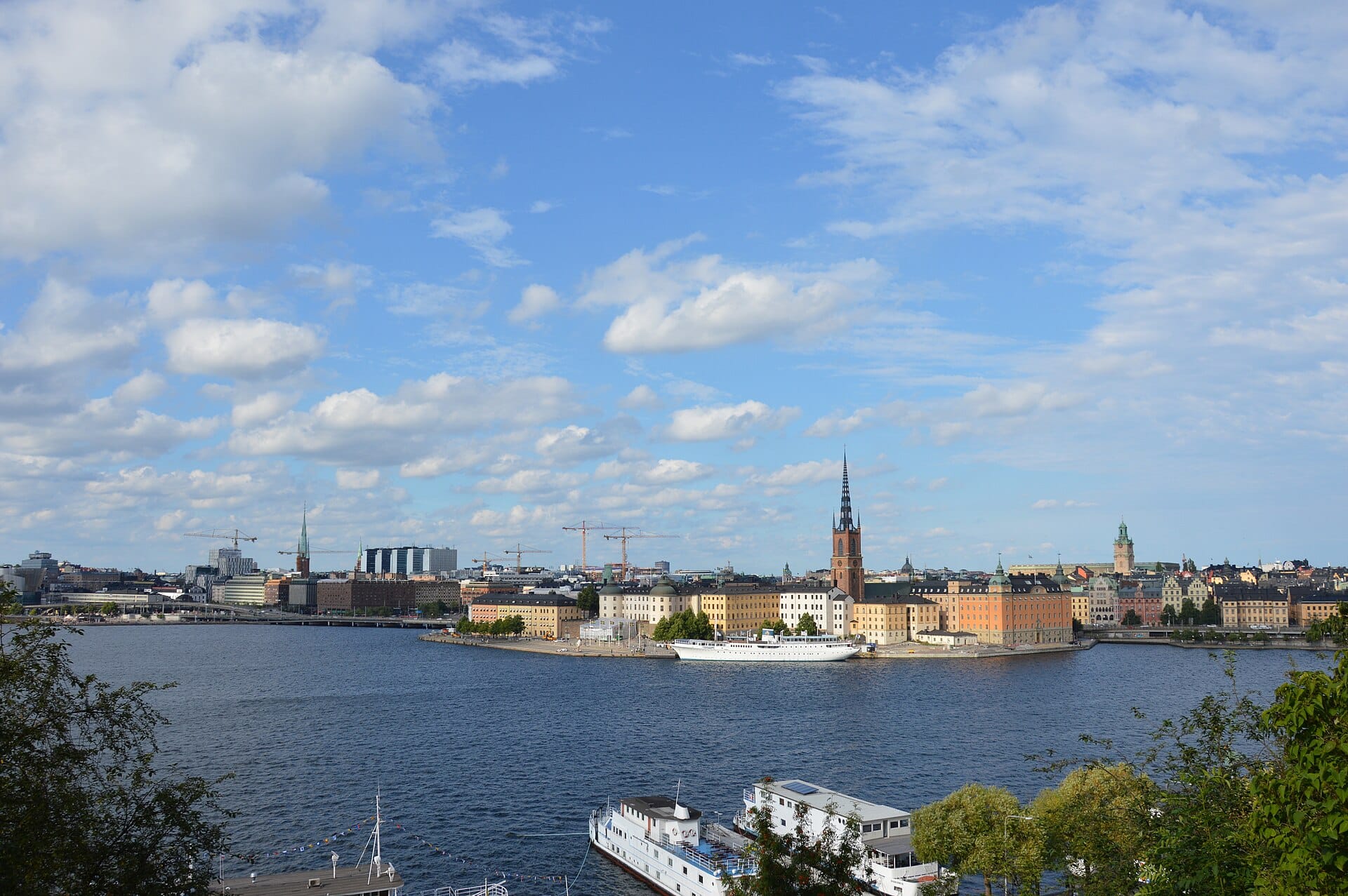
Monteliusvägen is a public pedestrian promenade on the Mariaberget cliff edge in northern Södermalm, one of Stockholm's main central islands. Running roughly 416 metres at an elevation of about 25 metres above the waterfront road Söder Mälarstrand, it offers an unbroken sightline across Lake Mälaren to Gamla Stan, Riddarholmen, Kungsholmen, and the tower of Stockholm City Hall. The path is free, open 24 hours year-round, and flat enough to navigate comfortably once you reach it.
The path is named after Oscar Montelius (1843–1921), a Swedish archaeologist best known for systematising Scandinavian prehistoric chronology. The area has a longer history as a public green space: the Mariaberget hillside was developed as a workers' park in the early twentieth century, and the current formalised promenade, at 416 metres, dates from the late twentieth century. For context on how Södermalm's character developed over that same period, see the Södermalm neighbourhood guide.
💡 Local tip
If you arrive from Slussen metro station, follow signs up Klevgränd — it is a steep 5-minute climb, but it deposits you almost at the eastern entrance of the path. Wear shoes with grip, particularly in winter.
The View: What You Are Actually Looking At
Standing at the railing, the water directly below is the western arm of Lake Mälaren as it flows toward the Baltic. In the middle distance, the copper-green rooflines and church spires of Gamla Stan crowd the island just across the water. Slightly to the right, the tall tower and Golden Hall mosaic facade of Stockholm City Hall mark Kungsholmen. On clear days the view extends further west along the lake, with forested islands dissolving into the horizon.
The panorama makes this one of the most reliable spots for photographing the Stockholm skyline. If you want a systematic comparison with other elevated vantage points in the city, the best views in Stockholm guide covers Skinnarviksberget, Fjällgatan, and several others. Monteliusvägen is the most accessible of the cliff-top options and the only one with a flat, maintained path running its entire length.
The view faces roughly north and west, which has a direct consequence for photography. The best natural light falls on the Old Town facades in the afternoon, when the sun moves around to the southwest. Sunrise light catches Södermalm's own rooftops behind you rather than the panorama ahead, so early mornings are better valued for atmosphere and empty paths than for front-lit subject matter.
Tickets & tours
Live prices and dates from our booking partner. If you book, we may earn a commission at no extra cost to you.
2-hour archipelago tour on a RIB speedboat
From 122 €Instant confirmationFree cancellationHaunted Stockholm exploration game and tour
From 12 €Instant confirmationFree cancellationFotografiska Stockholm entrance tickets
From 0 €Instant confirmationFree cancellationStockholm: Nature Reserve Hiking Tour with Campfire Lunch
From 102 €Instant confirmationFree cancellation
How the Experience Changes Through the Day
Early Morning
Before 8am on weekdays, the path is almost deserted. The silence is striking for a capital city: you hear water birds on the lake, the occasional tram on Hornsgatan below, and wind through the birch trees that line the inland side of the path. In summer, low golden light catches the church towers of Gamla Stan at a shallow angle, and morning mist sometimes sits on the water surface. In winter, the same hours can be icy and dark, but the city lights reflected on the water have their own appeal.
Midday and Afternoon
From around 10am onward, visitor numbers increase noticeably, particularly in summer. Tour groups occasionally move through, and the benches along the path fill with people eating lunch brought from nearby cafés on Hornsgatan. Afternoons in summer bring warm southwest light directly onto the City Hall and the water, making this the most photogenic window of the day. The path never becomes uncomfortably crowded, though: at its busiest it feels like a popular urban park rather than a tourist bottleneck.
Evening and Night
Sunset over Lake Mälaren from Monteliusvägen is legitimately spectacular in summer, when the sun tracks low across the sky to the northwest and sets behind the lake. The city lights come on gradually as dusk deepens, and the reflection of Gamla Stan in the water is one of the more memorable sights Stockholm offers for free. At night the path is quiet and reasonably well-lit along its length, though the approaches via Klevgränd are darker and steeper.
ℹ️ Good to know
In June and early July, Stockholm's northern latitude means sunset does not occur until after 10pm. The path stays light well past 9pm, so there is no need to rush to catch the evening sky.
The Walk Itself: A Practical Walkthrough
The promenade runs east-west along the cliff edge of Mariaberget, parallel to Bastugatan a block inland. The surface alternates between packed gravel and sections of wooden boardwalk. It is flat throughout, which makes the walk itself easy; the challenge is getting up to it. From Slussen, the most direct route is up Klevgränd, a narrow stairway street that rises sharply. The western entry can be reached from Mariatorget metro station with a gentler five-minute walk north.
Along the path, benches face the water at irregular intervals, some shaded by trees, some fully open to the panorama. There are information boards at various points. The vegetation on the inland side is a mix of mature trees and garden plantings that soften the urban setting. The entire length takes under ten minutes to walk without stopping, but most visitors move slowly, using the benches and phone cameras repeatedly.
There are no toilets on the path itself. The nearest facilities are in the cafés and restaurants on Hornsgatan, a short walk south. There are no food or drink vendors on the promenade.
⚠️ What to skip
In winter, the clay and wooden sections of the path become very slippery after rain or snow. Grippy footwear is important. The steep approach via Klevgränd is particularly hazardous when icy.
Getting There and Accessibility
The two most practical metro options are Slussen on the green and red lines, and Mariatorget on the red line. From Slussen, allow about 10 minutes: the uphill route via Klevgränd is steep but it is the most direct. From Mariatorget, the walk is flatter and a little shorter, about 5 minutes, approaching from the western end of the path. Bus 53 stops at Hornsgatan near Mariatorget and reduces the walk further.
Södermalm is well connected to the rest of central Stockholm. If you are planning a day that combines this viewpoint with other neighbourhoods, the guide to getting around Stockholm covers SL metro and bus options in detail. A standard SL single fare applies; there is no separate charge for this attraction.
The promenade itself is flat and is generally considered suitable for wheelchairs and pushchairs once you reach it. However, both main access routes involve either steep stairs (Klevgränd from Slussen) or hilly streets (from Mariatorget), with a longer but flatter alternative via Mariatrappgränd from Mariatorget. There is no car access directly onto the path.
Context: Where Monteliusvägen Fits in Södermalm
Monteliusvägen sits in a part of Södermalm that rewards wandering. Hornsgatan, immediately below, is one of the island's main commercial streets, lined with independent cafés, bakeries, and design shops. The SoFo district is a short walk east, known for its concentration of independent retail and places for a post-walk coffee or meal.
The viewpoint also puts you roughly equidistant from two other elevated spots worth comparing: Skinnarviksberget to the west, which is a rawer, more exposed hilltop with a slightly different angle on the lake, and Fjällgatan on the eastern side of Södermalm, which looks out over the Baltic inlet rather than the lake. Each has a distinct character; Monteliusvägen is the most formal and accessible of the three.
Combining the promenade with a visit to Fotografiska, the photography museum a 15-minute walk east on the waterfront, makes for a coherent half-day without backtracking. Alternatively, the nearby Katarina elevator offers a different kind of elevated perspective and is another free-to-approach landmark on this part of Södermalm.
Who Should Think Twice
If you are visiting Stockholm in winter and have limited outdoor tolerance, the exposed position and potential ice make this a less comfortable experience than the indoor alternatives. The view in overcast, grey weather is considerably less rewarding than on a clear day; if you arrive to a low cloud ceiling, the panorama collapses significantly. Anyone with serious mobility challenges will find the approach routes genuinely difficult.
The path itself offers no shelter, no seating with backs or armrests in all sections, and no services. It is a viewpoint, not a destination with programming. Visitors expecting interpretive content, guided narrative, or an indoor component will find it sparse.
Insider Tips
- The western section of the path, near the Mariatorget end, is consistently less busy than the central and eastern stretches. If you want an unobstructed bench for half an hour, start from the west and walk east rather than the reverse.
- The wooden boardwalk sections reflect light differently from the clay sections in photography. If you are shooting downward at textures rather than outward at the panorama, the boardwalk sections near the midpoint are the most photogenic underfoot.
- On warm summer evenings, locals bring wine and food to eat on the benches. The atmosphere between about 7pm and 9pm in June and July is notably relaxed and local rather than tourist-heavy.
- The treeline on the inland side provides partial shade on hot days. In high summer, the south-facing cliff edge gets full sun exposure by midday, so the shaded bench sections near the trees are noticeably cooler.
- If you approach from Slussen and find Klevgränd too steep on the way back, you can descend via Urvädersgränd or Trädgårdsgatan, which are less abrupt and connect back toward the waterfront at a gentler gradient.
Who Is Monteliusvägen For?
- Photographers wanting the City Hall-and-Old Town panorama without paying for an observation deck
- Couples looking for a quiet evening walk with lake views
- Travellers on a tight budget who want to understand Stockholm's geography from above
- Repeat visitors to Stockholm who want a quieter alternative to the main tourist circuit
- Families with pushchairs who can reach the flat promenade via the gentler approach from Mariatorget
Nearby Attractions
Other things to see while in Södermalm:
- Fjällgatan
Perched on the Stigberget cliff in Södermalm, Fjällgatan is a cobbled 18th-century street that doubles as one of Stockholm's finest free viewpoints. The panorama sweeps across Gamla Stan, Skeppsholmen, and Djurgården — and the street itself, lined with preserved wooden houses, is worth the uphill walk on its own terms.
- Fotografiska
Housed in a 1910 red-brick customs building on Södermalm's waterfront, Fotografiska is one of Europe's most serious photography museums. With rotating major exhibitions, a respected restaurant, and museum doors open until 23:00 every day, it works equally well as an afternoon cultural stop or an evening out.
- Katarina Elevator
The Katarina Elevator (Katarinahissen) is a public passenger lift at Slussen that carries you 38 metres up to a walkway on the Södermalm cliff edge, with wide views over Gamla Stan, the Riddarfjärden inlet, and Stockholm's island geography. It reopened in October 2023 after years of renovation, is currently free to ride when operating, and the journey itself takes under 30 seconds.
- Skinnarviksberget
Perched 53 metres above sea level on Södermalm, Skinnarviksberget is Stockholm's highest natural point within the inner city. It costs nothing to visit, is freely accessible at all hours (with an alcohol ban in the park between midnight and 7am), and delivers one of the most unobstructed panoramas in the Swedish capital, taking in the City Hall tower, Lake Mälaren, and the rooftops of Gamla Stan.
Planning a trip? Discover personalized activities with the Nomado app.