East Railay Beach: The Gateway Shore You Need to Understand Before You Arrive
East Railay Beach is the main arrival point for longtail boats reaching the Railay Peninsula. It is not a swimming beach, but it is the first thing most visitors see — and understanding what it is, and what it is not, shapes the entire Railay experience.
Quick Facts
- Location
- Ao Nang Subdistrict, Mueang Krabi District, Krabi Province, Thailand
- Getting There
- Longtail boat from Ao Nam Mao pier (no road connection to Railay)
- Time Needed
- 15–30 minutes to transit through; longer if you explore the mangroves or rest before crossing to West Railay
- Cost
- Free entry; longtail boat fares apply (verify current rates at the pier)
- Best for
- Arrivals, orientation, photography of limestone karsts, watching boat traffic
- Official website
- www.thailandtourismdirectory.go.th/en/attraction/1805
What East Railay Beach Actually Is
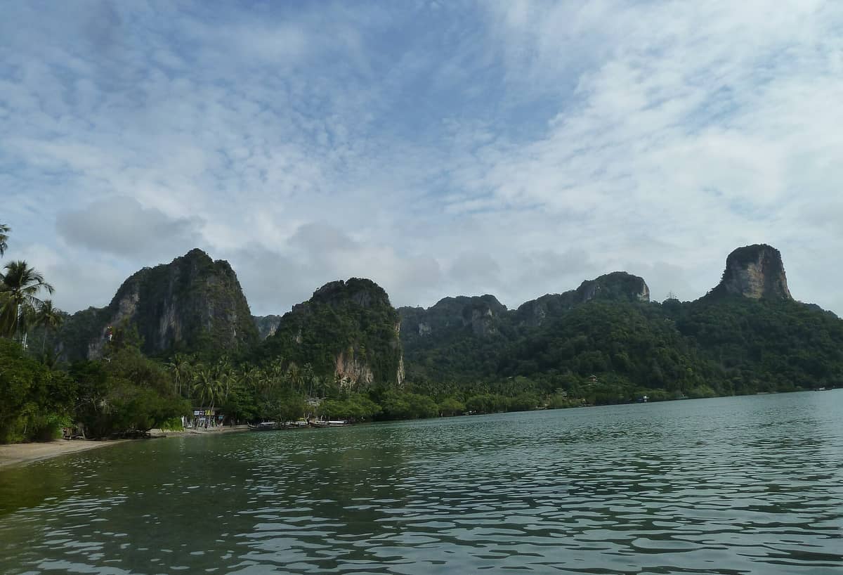
East Railay Beach is the eastern shoreline of the Railay Peninsula in Krabi Province, Thailand. It functions primarily as the boat landing zone for visitors arriving from the mainland, particularly from the Ao Nam Mao pier near Ao Nang. The beach itself is a tidal, mangrove-fringed mudflat rather than a classic white-sand swimming shore, and that distinction matters enormously if you are deciding how to spend your time on Railay.
The Thai Tourism Directory lists this area under the broader entry for Railay Beach (Thai: หาดไร่เลย์), with East Railay also described by the local alias Nam Mao Beach. No separate, standalone official listing exists for the eastern beach, which reflects its role as a functional entry point rather than a destination in its own right.
ℹ️ Good to know
East Railay is not a swimming beach. The eastern shore is shallow, tidal, and lined with mangroves. At low tide, the water recedes significantly and the ground becomes muddy. Arrive with the understanding that this is a transit point, not your sun-and-swim destination.
Arriving by Longtail: The First Few Minutes on Shore
The longtail boat ride from Ao Nam Mao takes roughly 15 to 20 minutes across open coastal water, and the approach to East Railay is genuinely striking. As the boat slows, two-hundred-metre limestone karst towers come into view on both sides, their vertical faces draped with vegetation and pocked with caverns. The scale is difficult to fully appreciate until the shoreline is close.
The landing itself depends on the tide. At high tide, boats can come relatively close to shore and passengers step onto a small pier or wade through shallow water. At low tide, the mudflat extends further out, and the approach can mean picking your way across exposed roots and wet sand. Sandals or water shoes are a practical choice for this reason, particularly if you are visiting outside peak dry-season months.
The sound of the journey shifts noticeably once you reach the eastern shore. The roar of longtail engines — high, two-stroke outboards that drive these boats at considerable speed — gives way to the lap of shallow water, the calls of boat operators coordinating departures, and the low hum of a shoreline that is always in motion. In the morning, when multiple boats arrive within minutes of each other, East Railay is lively and slightly chaotic in a purposeful way.
💡 Local tip
Wear footwear you do not mind getting wet. Even at high tide, the final step onto the East Railay shore often involves shallow water or soft, uneven ground. Flip-flops that stay on your feet are more useful than bare feet or heavy shoes.
Tickets & tours
Live prices and dates from our booking partner. If you book, we may earn a commission at no extra cost to you.
Island Hopping by Private Longtail Boat from Railay
From 130 €Instant confirmationFree cancellationDaily Cooking Class at Thai Cookery School in Krabi
From 42 €Instant confirmationFree cancellation7 islands speedboat excursion from Krabi
From 41 €Instant confirmationFree cancellationSpeedboat Tour to Hong Island Archipelago from Krabi
From 34 €Instant confirmationFree cancellation
The Mangrove Shore: What You See and Smell
Once on shore, the eastern beach reveals its distinct ecosystem. Mangrove trees line the inner edge of the water, their root systems visible at low tide as a dense tangle of arching props that filter the tidal zone. The smell is characteristically coastal and organic: salt air mixed with the earthy scent of exposed tidal sediment. This is not unpleasant, but it is a different sensory register than the powder-sand beaches on the western side of the peninsula.
Mangroves are ecologically significant coastal forests found across Thailand's southern coastline. They provide habitat for small fish, crabs, and bird species, and the mangrove fringe on East Railay is part of the broader limestone karst coastal landscape that defines the Railay Peninsula. Looking south from the landing area, the karst cliffs drop almost vertically into the water, forming a natural amphitheatre around the bay.
Photographers find the eastern shore useful in a different way than the west. The light on the karst faces in the early morning comes from the east, catching texture and colour on the cliff walls that the afternoon sun on West Railay cannot replicate. If you want photographs of the limestone towers with genuine depth, arriving early on the eastern side gives you that window.
Getting from East Railay to the Rest of the Peninsula
The path connecting East Railay to West Railay Beach runs directly across the narrow waist of the peninsula and takes around ten minutes on foot. The path is a concrete-paved walkway lined with bungalows, small restaurants, and rental shops. It is flat and easy to navigate in normal footwear, though it can feel exposed to the afternoon heat. At the western end, the sand and water change immediately: clear turquoise water, a wide white beach, and the dramatic backdrop of Phra Nang Nok cliff face.
From the same path, a short detour south leads to Phra Nang Beach, widely considered one of the finest beaches in Krabi Province. The walk takes roughly 15 to 20 minutes from the eastern landing and passes through a quieter section of the peninsula's interior. Phra Nang also contains the famous Phra Nang Cave, a shrine site that draws both Thai and international visitors.
Those with an interest in rock climbing will find that East Railay serves as the starting point for reaching several climbing areas. The rock climbing on Railay is internationally recognised, with routes on the karst faces accessible from both the eastern and western sides of the peninsula. Climbing operators can be found along the main path.
⚠️ What to skip
East Railay has no road connection to the mainland. The only way in or out is by boat. Keep this in mind when planning your departure, especially during rough weather or if you are on a schedule. Boat services may be reduced or suspended when sea conditions are poor.
How the Beach Changes Through the Day
Early morning, from around 7:00 to 9:00, is when East Railay is most active as a transit hub. Longtails from the mainland bring day visitors who have set out early for West Railay and Phra Nang. The boats arrive in groups, unload quickly, and turn around. The atmosphere is purposeful and fast-moving. This is also the coolest part of the day, and the light on the eastern cliff faces is at its best.
By mid-morning, the flow of arrivals slows and the shore becomes quieter. Those who are staying on the peninsula begin using the eastern beach for the practical functions it supports: watching boats, picking up supplies from longtails, or simply sitting with coffee at one of the small cafes that face the water. At high tide, the water covers the mudflat partially, creating a more visually appealing scene than the exposed tidal flats at low tide.
Late afternoon and early evening see the departure rush, with visitors boarding longtails back to Ao Nam Mao or Ao Nang. The atmosphere is relaxed but time-aware. The light at this hour falls on the western cliffs across the peninsula rather than the eastern shore, so there is less photographic incentive to linger here specifically. The karsts take on warm tones at this hour, visible as you cross back to the western beach.
Weather, Seasons, and When to Visit
Railay's climate follows Krabi Province's broader pattern. The dry season runs roughly from December to March, with lower humidity and more settled sea conditions. This is the period when boat services are most reliable and the peninsula is most accessible. If you are visiting during the Southwest Monsoon, which typically runs from May through October, sea conditions can make crossings rougher and boat schedules less predictable. The best time to visit Krabi for beach activities is generally December through February, when conditions are most stable.
Visiting in the rainy season is possible but requires flexibility. Boats may be cancelled on short notice, and the eastern shore can look particularly grey and overcast during sustained rain. The mangroves, however, are deeply green and the atmosphere is notably less crowded. For travellers who want Railay with fewer people and do not mind occasional rain, the shoulder months of November and April offer a reasonable compromise. See the guide to visiting Krabi in the rainy season for more detail on what to expect.
Accessibility and Practical Considerations
East Railay presents real accessibility challenges. The boat journey itself, the tidal landing conditions, and the uneven ground across the tidal zone are all barriers for visitors with significant mobility limitations. The path between East and West Railay is paved and relatively flat, but the boat boarding process at both ends involves steps, movement on unstable surfaces, and variable water depths. No verified wheelchair-accessible landing facilities have been identified. Visitors with mobility considerations should contact boat operators in advance and assess conditions on the day.
The beach has no official admission fee. Boat fares apply for the crossing and these should be verified at the pier before departure, as they are not officially fixed and may vary by season or operator. The Thailand Tourism Directory displays hours of 11:00 PM to 11:00 AM daily, an apparent inconsistency for a natural beach; treat the area as accessible during daylight hours and verify any service-specific hours locally.
Insider Tips
- Check the tide times before you book your longtail. Low tide on East Railay means a longer walk across wet mud from the water's edge to the shore path. Arriving around mid-tide gives you the clearest, most straightforward landing.
- Drop your bags at your accommodation before attempting any walks. The path from East Railay to Phra Nang Beach is pleasant without luggage and genuinely difficult with a large backpack in midday heat.
- If you want to photograph the karst towers with dramatic morning light, position yourself on the eastern shore between 7:30 and 9:00. The angle of the sun on the cliff faces at this hour produces texture and shadow that disappear later in the day.
- The small restaurants facing the eastern beach tend to be cheaper than those on the West Railay side. If you are watching your budget, eating on the east saves you a meaningful amount over several days.
- When leaving Railay, arrive at the East Railay pier with ten to fifteen minutes to spare, particularly during peak season. Boats fill up and depart when full, not on a fixed schedule, and waiting for the next boat can add an unplanned thirty minutes to your journey.
Who Is East Railay Beach For?
- Travellers arriving by longtail who want to understand the layout of the peninsula before exploring
- Photographers interested in morning light on Krabi's limestone karst formations
- Budget travellers who want to eat and rest in a quieter, less tourist-priced section of Railay
- Rock climbers using East Railay as a base for accessing climbing routes on the southern karsts
- Visitors who appreciate coastal ecology and want to observe mangrove environments
Nearby Attractions
Other things to see while in Railay Peninsula:
- Phra Nang Beach
Phra Nang Beach sits at the southern tip of Railay Peninsula, hemmed in by sheer limestone cliffs and reachable from the mainland only by longtail boat, or on foot from Railay East. The roughly 450-metre stretch of pale sand, a sea cave shrine, and turquoise water make it one of Krabi Province's most visually striking beaches — though its reputation means it is rarely quiet during peak hours.
- Phra Nang Cave & Princess Shrine
Tucked into the limestone cliffs at the southern tip of Railay Peninsula, Phra Nang Cave holds a shrine to a revered sea-princess spirit, surrounded by hundreds of carved wooden offerings left by local fishermen. The cave sits steps from one of Krabi's most photographed beaches, making it easy to combine a cultural visit with a morning swim or a sunset sit on the sand.
- Railay Lagoon
Railay Lagoon, also known as Princess Lagoon, is a secluded tidal pool carved into the limestone heart of the Railay peninsula. Reaching it requires a steep, rope-assisted scramble that most visitors never attempt, which is exactly why the reward feels so outsized for those who do.
- Railay Rock Climbing
Railay Peninsula is one of Southeast Asia's most striking climbing destinations, where sheer limestone karst towers rise directly from the Andaman Sea. Whether you've never touched a climbing wall or you're chasing multi-pitch routes above the ocean, the cliffs at Railay deliver a setting that's genuinely hard to match.
Planning a trip? Discover personalized activities with the Nomado app.