Coal Harbour: Vancouver's Waterfront District Worth More Than a Quick Walk
Coal Harbour is a free-to-explore waterfront neighbourhood on Burrard Inlet, stretching between Canada Place and the edge of Stanley Park. It combines a paved seawall, marina views, mountain backdrops, and one of the most photographed skylines in western Canada.
Quick Facts
- Location
- Burrard Inlet waterfront, Downtown Vancouver, between Canada Place and Stanley Park
- Getting There
- Burrard or Waterfront SkyTrain stations (Canada Line / Expo Line); short walk north to the water
- Time Needed
- 45 minutes to 2 hours depending on pace; more if connecting to Stanley Park Seawall
- Cost
- Free to walk. Seaplane flights, harbour tours, and nearby attractions priced separately in CAD
- Best for
- Morning walkers, photographers, first-time Vancouver visitors, families, and those combining with Stanley Park
- Official website
- www.destinationvancouver.com/neighbourhoods/coal-harbour
About Coal Harbour
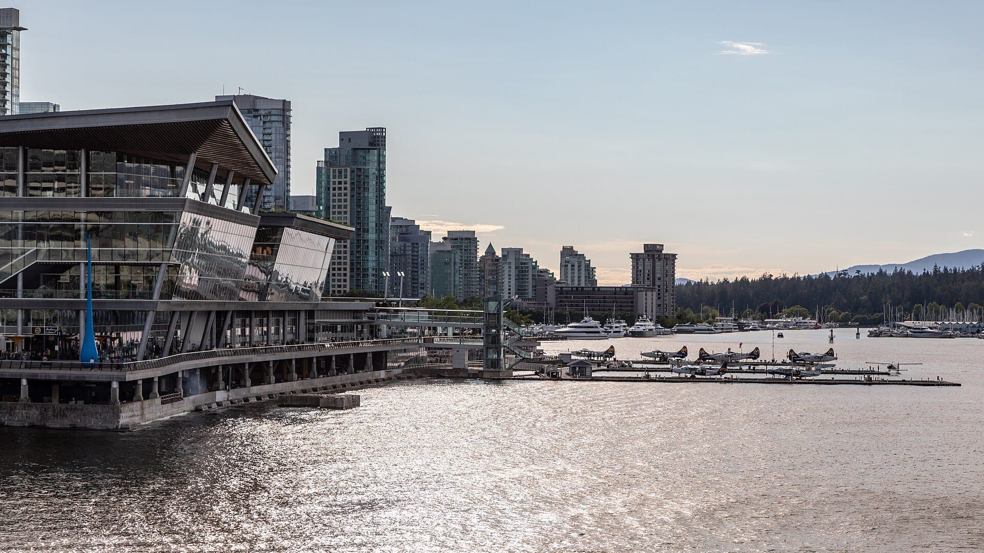
Coal Harbour is not a single attraction with a ticket booth. It is a neighbourhood and waterfront promenade on the south shore of Burrard Inlet, running roughly from the Vancouver Convention Centre and Canada Place in the east to the entrance of Stanley Park in the west. The area includes a continuous paved seawall, two marinas, several public plazas, a floatplane terminal, luxury hotels, and some of the most unobstructed mountain-and-water views available from anywhere in central Vancouver.
The name comes from coal deposits discovered at this inlet in 1859 by Colonel Moody of the Royal Engineers. That geological footnote shaped the entire city: when the Canadian Pacific Railway chose nearby Burrard Inlet as its western terminus in the 1880s, it accelerated Vancouver's incorporation as a city in April 1886 and turned this stretch of waterfront into an industrial hub of sawmills, boat yards, and railway infrastructure. Almost none of that industry remains visible today.
ℹ️ Good to know
The seawall here is fully paved and flat, making it one of the most accessible stretches of waterfront in the city. Wheelchairs, strollers, and cyclists all use the path, though cyclists have a designated lane separate from pedestrians.
The View and Why It Works
Stand at the seawall between the Westin Bayshore Hotel and Harbour Green Park and you get something rare in a major city: a completely unobstructed sight line across open water to the North Shore mountains. On clear days, the peaks of Mount Seymour, Grouse Mountain, and the Lions frame the skyline with snow on them for roughly half the year. In the foreground, float planes from Harbour Air lift off from the terminal near Canada Place every few minutes, adding kinetic energy to what might otherwise be a static postcard.
The light changes dramatically by time of day. Early morning, roughly 7 to 9 am, the mountains catch alpenglow while the water sits glassy and the marina reflects the moored sailboats in near-perfect symmetry. Midday is fine for walking but the light flattens. Late afternoon, particularly in summer, brings a warm golden wash across the glass towers of the Coal Harbour condominiums and the sails of Canada Place, which is when most photographers set up along the seawall railing.
For a broader survey of where to find views like this across the city, the best views in Vancouver guide provides a useful comparison of elevated and waterfront vantage points.
Walking the Seawall: What You Pass and in What Order
Starting from the Canada Place end, the first section of the Coal Harbour seawall passes the floatplane terminal and the cruise ship berths. On summer mornings when cruise ships are in port, the scale of those vessels against the city skyline is genuinely striking. The smell here is unmistakably oceanic: salt water, diesel fumes from the floatplanes, and the faint sweetness of low tide exposing barnacle-covered pilings.
Moving west, the path opens into Harbour Green Park, a well-maintained grassy area with benches facing the water. This is where locals walk dogs in the early morning and where lunch crowds spill out from the nearby office towers on weekday afternoons. The park connects to the Coal Harbour Community Centre, which has public washrooms accessible during operating hours.
Continuing west past the Westin Bayshore Hotel, the seawall narrows slightly before the path merges into the Stanley Park Seawall near Devonian Harbour Park. From Coal Harbour it is a natural, uninterrupted transition into the park. There is no gate, no fee, no formal boundary marker. The transition is seamless.
If you plan to continue into the park, the Stanley Park Seawall extends the walk considerably, circling the entire peninsula for about 10 kilometres total. Most people doing the full loop start from Coal Harbour.
Historical Layers: From Coal Deposits to Expo 86
The transformation of Coal Harbour from industrial waterfront to polished promenade took most of the twentieth century. The Westin Bayshore Hotel, which opened in 1961, was an early signal that leisure and tourism were replacing industrial use along this shore. Howard Hughes famously rented out several floors of the Bayshore in 1972, an event still referenced in the hotel's own marketing. Canada Place, the convention and cruise ship facility whose roof is designed to resemble the sails of a ship, was built for Expo 86 and remains the architectural centrepiece of the eastern end of the harbour.
The residential towers that now define Coal Harbour's skyline came later, mostly developed in the 1990s and 2000s as part of a broader push to bring density to the downtown waterfront. The neighbourhood is now among the most expensive residential postcodes in Canada, and that fact shapes the atmosphere: the seawall is immaculate, the parks are manicured, and the overall feeling is of a place that is carefully managed rather than organically evolved.
How Weather Affects the Experience
Vancouver has a temperate oceanic climate, which means the mountains are frequently obscured by cloud from October through March. The view that makes Coal Harbour worth visiting, those snow-capped peaks reflected in calm water, is not guaranteed. On overcast winter days, the harbour can feel grey and the walk loses much of its drama. The seawall is still usable in rain, and the floatplanes still operate, but managing expectations matters.
Summer, roughly June through August, offers the most reliable conditions: clear skies, warm temperatures in the high teens to low twenties Celsius, and long daylight hours that make evening walks genuinely pleasant. September and early October can also be excellent, with fewer clouds than winter but without the peak-season crowds. If you are visiting in winter and the clouds are heavy, pair the walk with a café stop and consider whether the views of Stanley Park's tree line still justify the trip. For most people, they do.
For a month-by-month breakdown of what to expect, the Vancouver weather guide covers seasonal patterns in detail.
Practical Walkthrough: Getting There and Around
Coal Harbour is accessible without a car. Waterfront Station, the downtown hub for the Expo Line, Canada Line, SeaBus, and West Coast Express commuter rail, is a seven-minute walk east from Harbour Green Park. Burrard Station on the Expo and Millennium Lines is a similar distance south, on Burrard Street. From either station, follow the signs or simply walk north until you hit water.
Driving is possible but parking in the surrounding area uses paid parkades, and finding street parking near the waterfront is unpredictable. For most visitors staying downtown, walking is faster and simpler.
The seawall surface is smooth paving throughout and entirely flat, with curb cuts at road crossings. Accessibility is good. Public washrooms are available at Harbour Green Park (inside the Coal Harbour Community Centre during operating hours) and at Canada Place. There are no steps on the main seawall route. Cycling is permitted in the designated lane but cyclists should expect pedestrian traffic, particularly on weekends.
💡 Local tip
Photography tip: position yourself west of the Coal Harbour Marina and face northeast in the early morning for the best combination of mountain backdrop, marina reflection, and soft directional light. The Canada Place sail roof appears in the middle distance at that angle.
Who Should Skip This, and Why
Coal Harbour is one of the more straightforward stretches of Vancouver's seawall, which means it is also one of the less surprising. Visitors who have already walked the Stanley Park Seawall will find the Coal Harbour section familiar in character, and those specifically seeking wild nature, interesting food stalls, or cultural density will not find much of that here. The neighbourhood is residential and corporate in equal measure, and the seawall reflects that: clean, pleasant, and somewhat uniform.
Travelers after a more textured waterfront experience might prefer Granville Island Public Market, which has the food vendors, working studios, and neighbourhood character that Coal Harbour lacks. Similarly, those looking for historical depth would find Gastown more rewarding for the same amount of walking time.
Insider Tips
- The floatplane operations from Harbour Air are most active in the morning. If you want to watch planes depart and land over the water, aim to be at the eastern end of the seawall before 10 am.
- The Coal Harbour Community Centre has free public washrooms during operating hours. Note these before you commit to a long walk toward Stanley Park.
- In summer, the seawall between Harbour Green Park and the Stanley Park entrance fills with cyclists after 4 pm on weekdays. If you prefer a quieter walk, come before 9 am or after 7 pm.
- The benches along the seawall west of the Bayshore Hotel face directly north across the water and catch the afternoon sun. They are rarely fully occupied even when the seawall path itself is crowded.
- Parking validation is not available from the seawall itself. If you drive, factor in parkade costs on the walk out, not after the fact.
Who Is Coal Harbour For?
- First-time Vancouver visitors who want an easy introduction to the city's waterfront character
- Early-morning walkers looking for mountain views and calm water before crowds arrive
- Photographers seeking the classic Vancouver skyline shot with North Shore mountains
- Families with strollers or visitors with mobility considerations, given the flat paved surface
- Anyone planning to continue directly into Stanley Park without a break
Nearby Attractions
Other things to see while in Downtown Vancouver:
- BC Place
BC Place is Vancouver's premier indoor stadium and event venue, sitting on the north side of False Creek on the southeastern edge of downtown. From BC Lions football to Whitecaps soccer, international concerts, and trade expos, this retractable-roof arena is the city's largest indoor gathering space. Here is what it is actually like to visit, and how to make the most of your time there.
- Bill Reid Gallery of Northwest Coast Art
Opened in 2008, the Bill Reid Gallery of Northwest Coast Art is Canada's only public gallery dedicated entirely to Indigenous art of the Northwest Coast. Tucked into a quiet courtyard in downtown Vancouver, it offers an intimate, carefully curated encounter with Haida and other Northwest Coast artistic traditions.
- Canada Place
Canada Place anchors Vancouver's downtown waterfront with its sail-shaped roof, working cruise terminal, and free public promenade overlooking Burrard Inlet. Whether you're passing through or planning your first visit, here's what actually makes it worth your time.
- Robson Street
Robson Street runs through the heart of downtown Vancouver, connecting the central business district with the residential West End. A historic commercial strip dating to the 1890s, it packs international retailers, independent cafes, and street-level energy into a walkable stretch that changes character dramatically between morning and night.