Border Field State Park: Where San Diego Meets the Border
Border Field State Park occupies the southwestern corner of the continental United States, where Pacific surf meets the U.S.–Mexico border fence. It offers coastal wetlands, a historic marble boundary monument, and views toward Friendship Park — the U.S.-side gathering space has been closed since 2020, so confirm current access before you go.
Quick Facts
- Location
- Monument Road, San Diego, CA 92154 — approx. 15 miles south of downtown San Diego
- Getting There
- Car recommended: take I-5 south, then Dairy Mart Road and Monument Road west to the coast. No direct MTS service to the park entrance.
- Time Needed
- 2–3 hours for a full walk to the beach and Friendship Park; allow extra time if Monument Road is flooded
- Cost
- Day-use parking fee charged (amount subject to change — verify at parks.ca.gov before visiting)
- Best for
- History buffs, birders, solitude seekers, photographers, and anyone curious about the border itself
- Official website
- www.parks.ca.gov/?page_id=664
What Border Field State Park Actually Is
Border Field State Park is a California state park occupying the far southwestern corner of the continental United States, at the point where the Pacific Ocean meets the international boundary between the United States and Mexico. The park sits within the broader Tijuana River National Estuarine Research Reserve, meaning the landscape around you is not just scenic — it is ecologically protected and actively studied. Coastal wetlands, scrub-covered bluffs, and a wide sandy beach extend along the Pacific edge, while the rusted steel border fence defines the park's southern boundary.
Most visitors come for one of three reasons: to see Boundary Monument No. 258, the original marble obelisk placed by the U.S.–Mexico Boundary Commission after the Mexican–American War in the mid-19th century; to visit Friendship Park, the small binational gathering space at the border fence; or simply to reach a beach that, on weekdays, may have almost no one on it. The combination of political significance, natural beauty, and near-total quiet makes this park unlike anywhere else in San Diego County.
⚠️ What to skip
Monument Road — the primary vehicle access road into the park — is frequently flooded after rain or high tides. California State Parks may close the park with little notice. Always check current conditions at parks.ca.gov or call +1 619-575-3613 before making the drive.
The Drive In and the Walk to the Beach
From the I-5, the route south through Dairy Mart Road and Monument Road passes through a transition zone that is genuinely unlike the rest of San Diego. Industrial logistics facilities and agricultural flatlands give way to the low, reed-filled channels of the Tijuana River estuary. By the time Monument Road narrows to a single lane approaching the parking area, the city feels far away. This is not a park you stumble upon — it requires intention.
From the parking area, a flat trail runs roughly a mile toward the ocean, passing through coastal sage scrub and wetland margins. On still mornings, the calls of shorebirds carry across the estuary: the Tijuana River National Estuarine Research Reserve hosts more than 370 recorded bird species, including several that are state or federally listed as threatened. Birders who visit in winter or during spring and fall migration periods will find the estuary section particularly active. Bring binoculars.
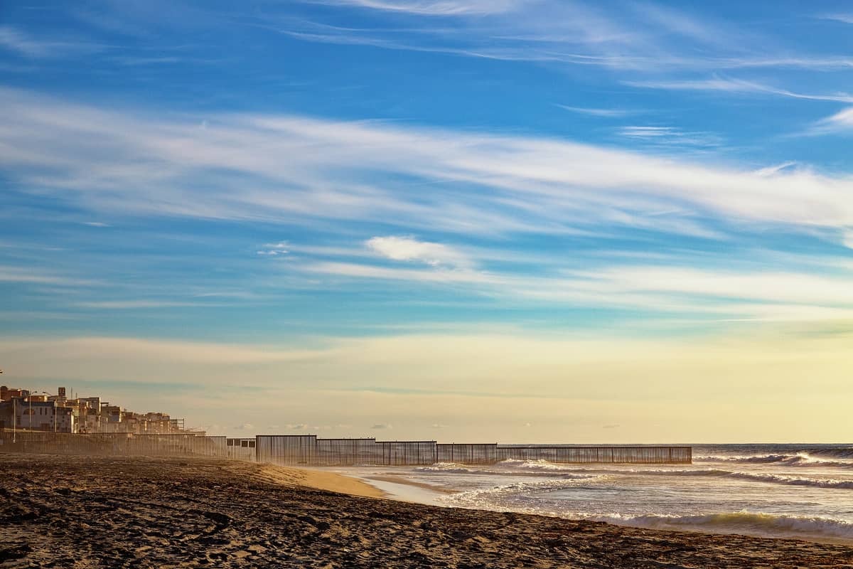
The beach at the western end is wide, backed by low bluffs, and faces open Pacific swell. The border fence runs directly into the ocean here, disappearing into the surf. On weekday mornings, you may have the beach almost entirely to yourself, the only sounds being the wind and the waves breaking against the fence pilings. Weekend afternoons draw more visitors, particularly families, but the park never approaches the crowd levels of San Diego's urban beaches.
Friendship Park and the Border Fence
Friendship Park is the small area at the western end of the border fence, on the U.S. side, designated as a gathering space for people to meet across the boundary. It was dedicated in 1971 by First Lady Pat Nixon, who reportedly said people should be able to meet here without a barrier. The history of what has actually stood at that spot since then, from chain-link to the current layered steel structure, tells a different story about how U.S. border policy has evolved over five decades.
Access to the Friendship Park area on the U.S. side has been completely closed since February 2020, and the park's proximity to active federal border operations means that any future access would depend on policy changes with minimal public notice; check the Friends of Friendship Park website (friendshippark.org) for the most current status and any binational events on the Mexican side before you go.
ℹ️ Good to know
Boundary Monument No. 258 is one of the original marble obelisks placed by the joint U.S.–Mexico Boundary Commission in the mid-19th century, following the Mexican–American War. It marks the western terminus of the international land boundary. The monument itself is small, weathered, and historically significant in a way that rewards knowing what you are looking at.
How the Experience Changes by Time of Day
Early morning — arriving around sunrise — offers the best light for photography along the beach and the strongest conditions for wildlife observation in the estuary. The low horizontal light picks out the texture of the fence and the bluffs in ways that midday sun flattens entirely. The air is typically cooler and calmer, and border activity in the surrounding area tends to be quieter.
Midday works well for simply walking the trail and reaching the beach, but the coastal marine layer that San Diego sees frequently in June and July — locally called June Gloom — can persist until early afternoon, keeping the park grey and cool. This is not necessarily a drawback: the muted light gives the estuary a certain atmospheric quality, and the cooler temperatures make the walk comfortable.
Late afternoon, particularly in autumn, produces some of the park's most photographically rich conditions. September and October bring warm, clear air and golden-hour light that illuminates the fence, the monument, and the bluffs simultaneously. These are also months when the estuary's bird populations are augmented by southbound migrants.
Practical Walkthrough: What to Prepare For
Wear shoes you are comfortable getting sandy or muddy. The trail from the parking area to the beach is flat and compacted, but wet weather or tidal overflow can leave sections muddy. There is no food or water available inside the park, and the nearest services are several miles away back toward Imperial Beach — bring what you need.
The California State Parks accessibility overview notes that terrain and road conditions significantly affect access for visitors with mobility limitations. The sole access road itself is unpaved in sections, and the trail to the beach includes soft sandy stretches. Visitors with specific accessibility needs should call the park directly at +1 619-575-3613 to get current, accurate information before making the trip.
For those planning to explore broader San Diego on the same trip, Border Field pairs logistically with a visit to Cabrillo National Monument on Point Loma — both are historically significant boundary markers of a kind, and both sit at coastal extremities of the region. Sunset Cliffs Natural Park is another dramatic coastal stop that fits naturally into a southern San Diego day.
Who This Park Is For — and Who Should Skip It
This is not a park for visitors who want amenities, maintained facilities, or reliable access. It rewards travelers who are willing to check conditions in advance, accept that they may be turned back by a flooded road, and find value in a landscape that is both ecologically intact and politically charged. The park does not try to be convenient, and it does not apologize for that.
Travelers looking for a very different kind of San Diego outdoor experience — more accessible hiking with panoramic views — will find Cowles Mountain or Torrey Pines State Natural Reserve better fits. Those primarily interested in border history and binational context may also want to consider a day trip to Tijuana as a companion experience — seeing the boundary from both sides adds a dimension that visiting only the U.S. side cannot.
Visitors with young children should be aware that the walk to the beach is approximately one mile each way on an exposed, unshaded trail, there are no restroom facilities near the beach itself, and the coastal winds can be strong. It is manageable but requires realistic planning.
Photography Notes
The visual opportunities here are distinctive: the steel border fence running into the Pacific surf, the weathered marble monument, the flat estuary channels with reflections of sky, and the contrast between the natural landscape and the infrastructure of the boundary. Wide-angle lenses capture the full sweep of fence, beach, and bluff. A telephoto is useful for birds in the estuary and for compressing the visual relationship between the fence and the Tijuana hillsides beyond it.
One important note: you are in close proximity to active federal border enforcement operations. Exercise common sense and respect any marked restricted zones. Photography of CBP officers or operations without consent is not prohibited by law on public land, but keep your focus on the landscape and the monument rather than border agents.
Insider Tips
- Check the Tijuana River National Estuarine Research Reserve website alongside the California State Parks page — the reserve sometimes posts more timely updates on trail and road conditions after rain events.
- The monument and beach area are far enough from the parking lot that casual visitors often turn back before reaching the shore. If you walk the full mile to the beach, you will almost certainly have it to yourself on a weekday.
- Autumn (September through November) is the sweet spot for visiting: low chance of road flooding, warm dry air, excellent bird activity during migration, and the best light conditions of the year.
- The Friends of Friendship Park organization occasionally coordinates binational events at the fence — moments when people on both sides gather simultaneously. Following their schedule can transform a scenic walk into something genuinely memorable.
- There is zero cell signal in most of the park. Download offline maps and the California State Parks park page before you arrive. This also means the park offers a rare experience of genuine disconnection within minutes of a major metropolitan area.
Who Is Border Field State Park For?
- History and border culture enthusiasts who want to understand the physical reality of the U.S.–Mexico boundary
- Birders and nature observers targeting the Tijuana River estuary's diverse shorebird and migratory species
- Photographers seeking dramatic coastal light and the visual contrast of natural landscape against border infrastructure
- Solitude seekers who want a San Diego beach without the crowds
- Thoughtful travelers who want context about the border region beyond what downtown San Diego offers
Nearby Attractions
Combine your visit with:
- Anza-Borrego Desert State Park
Anza-Borrego Desert State Park stretches across more than 600,000 acres of Colorado Desert in eastern San Diego County, making it one of the largest state parks in the United States. From spring wildflower carpets to ancient slot canyons and some of the darkest skies in Southern California, it rewards visitors who plan carefully and respect the terrain.
- Cedar Creek Falls
Cedar Creek Falls is a backcountry waterfall deep inside Cleveland National Forest, reached by a strenuous 6-mile round-trip hike from Ramona. A mandatory day-use permit keeps crowds manageable, but you'll earn every step of the descent into this rugged gorge. This guide covers the permit process, trail conditions, safety warnings, and what to realistically expect.
- Chicano Park
Chicano Park is a National Historic Landmark tucked beneath the San Diego–Coronado Bridge in Barrio Logan, where more than 80 monumental murals cover the concrete pillars of a freeway overpass. Free to enter and open daily, it is one of the most culturally layered outdoor spaces in the American Southwest.
- Cowles Mountain
Cowles Mountain is the highest point in the City of San Diego, rising 1,591 feet above sea level inside Mission Trails Regional Park. The main trail climbs 1.5 miles from the Golfcrest Drive trailhead, gaining roughly 950 feet of elevation, and rewards hikers with panoramic views stretching from the Pacific to the desert. Entry is completely free.