Cowles Mountain: Hiking San Diego's Highest Peak
Cowles Mountain is the highest point in the City of San Diego, rising 1,591 feet above sea level inside Mission Trails Regional Park. The main trail climbs 1.5 miles from the Golfcrest Drive trailhead, gaining roughly 950 feet of elevation, and rewards hikers with panoramic views stretching from the Pacific to the desert. Entry is completely free.
Quick Facts
- Location
- 7001 Golfcrest Dr, San Diego, CA 92119 (San Carlos neighborhood, Mission Trails Regional Park)
- Getting There
- MTS Bus routes serve the surrounding San Carlos area; driving via Hwy 125 to Navajo Road west, then right on Golfcrest Drive is the most practical option
- Time Needed
- 2–3 hours round trip (including summit time)
- Cost
- Free — no ticket, permit, or parking fee
- Best for
- Sunrise hikes, city views, casual fitness routines, families with older children
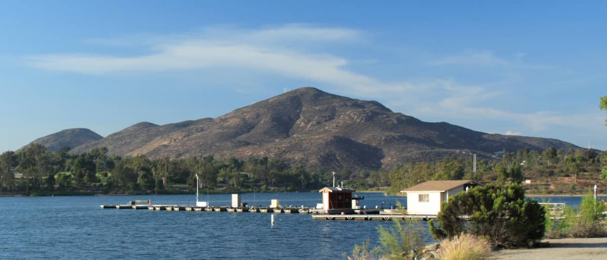
What Cowles Mountain Actually Is
Cowles Mountain is the highest point within the City of San Diego, topping out at 1,591 feet (approximately 485 meters) above sea level. It sits inside Mission Trails Regional Park, one of the largest urban parks in the United States, in the San Carlos neighborhood in the city's eastern interior. Despite being thoroughly embedded in a residential part of San Diego, the summit offers views that feel genuinely expansive: on a clear day you can pick out the Pacific Ocean to the west, the Cuyamaca Mountains to the east, and the entire San Diego basin sprawling below.
The mountain is named for George A. Cowles, a 19th-century rancher and businessman in San Diego County. The City and County of San Diego jointly purchased the land on December 31, 1974, and the park was dedicated in October 1984. A stone plaque at the summit records its elevation and dedication — a small, easy-to-miss detail that rewards those who take a moment to look.
ℹ️ Good to know
Cowles Mountain is free to hike year-round. The trailhead at 7001 Golfcrest Drive has restrooms, a water fountain, and posted trail information. Parking in the adjacent lot is also free, but the lot fills quickly on weekend mornings after about 7:30 am.
The Hike: What to Expect on the Trail
The most popular route starts at the Golfcrest Drive trailhead, reached from Highway 125 by exiting at Navajo Road, heading west roughly two miles, then turning right onto Golfcrest Drive. The lot appears on your right. The trail climbs about 1.5 miles to the summit with around 950 feet of elevation gain — classified as moderate to difficult, depending on your fitness level. The surface is natural granite and decomposed granite, loose in sections and uneven throughout, so trail shoes or hiking boots are strongly recommended over casual sneakers.
The first third of the ascent is the steepest. Rocky steps and exposed granite slabs dominate this stretch, and the path narrows in places, requiring you to watch your footing rather than the view. Above the initial climb, the gradient eases slightly and switchbacks carry you through chaparral scrub — coastal sage, black sage, chamise, and the occasional prickly pear. The smell of sage after light rain or in the heat of the day is particularly strong here, one of those sensory details that distinguishes this trail from a gym staircase.
The summit plateau is modest in size but striking in exposure. A concrete U.S. Geological Survey benchmark marker sits at the highest point. On clear mornings you can see Coronado, Point Loma, the downtown skyline, and, in rare exceptionally clear conditions, Santa Catalina Island off the Los Angeles coast far to the northwest. Round trip takes most people between 1.5 and 2.5 hours depending on pace and time spent at the top.
An alternate route begins at Big Rock Park on Mesa Road in Santee. This path is longer and less trafficked, which makes it worth considering if the Golfcrest lot is full. Both routes are rated difficult by park rangers due to steep grades and uneven surfaces. Neither is paved or accessible to wheelchair users.
Time of Day: How the Experience Changes
Sunrise is the most rewarding time to be on Cowles Mountain. The sky transitions from deep blue to orange behind the mountains to the east, the coastal layer of marine fog often sits low over the ocean and bay giving the city a soft, cinematic look, and the trail is cool and quiet. Arriving at the trailhead by 5:30–6:00 am on weekday mornings means a genuinely peaceful ascent. On weekend mornings during summer, even this early window fills up fast.
By 8:00 am on weekends, the parking lot at Golfcrest Drive is typically full and cars line Navajo Road. The trail itself becomes a two-way stream of hikers, with faster runners weaving past families and dogs on leashes. The noise and congestion peak between 8:00 am and 10:30 am. If you cannot go at sunrise, late afternoon on a weekday — arriving around 3:30–4:00 pm — is the next best option for a less crowded experience.
Midday in summer should be approached carefully. The trail is almost entirely exposed after the lower section, with minimal shade above the scrub line. Temperatures at the summit can run significantly hotter than coastal San Diego, particularly September through October when Santa Ana wind conditions push inland heat toward the coast. Bring more water than you think you need.
⚠️ What to skip
The trail itself has no gate and is technically accessible around the clock, but the Mission Trails park staging areas and parking lots close at 5 pm from November through March and 7 pm from April through October. If you plan to hike after dark, you will need to park on the street and use a headlamp. The trail is not lit.
Weather, Seasons, and When to Go
San Diego's Mediterranean climate makes Cowles Mountain hikeable every month of the year, but the experience differs meaningfully by season. October and November offer the best combination of comfortable temperatures, reliable visibility, and manageable crowds. The summer marine layer — a persistent coastal fog known locally as 'June Gloom' — can obscure the lower parts of the skyline views well into mid-morning during May through July, though the summit often sits above the fog line, giving an unusual perspective of looking down on clouds.
Winter hiking (December through February) brings cooler temperatures at the summit, occasionally wet and slippery granite, and a genuine risk of rain. San Diego's rainy season concentrates most annual precipitation between roughly November and March. After rain, the trail surface becomes slick in places and the lower chaparral releases a sharp, clean scent. Views can be exceptional on clear post-rain days when the air is washed free of haze. Carry a layer; the summit can feel several degrees cooler than the trailhead.
If you are planning a broader San Diego outdoor itinerary, the best hikes in San Diego guide covers Cowles Mountain alongside other trails in the region, including coastal and canyon options that contrast usefully with this inland peak.
Practical Details: Getting There, Gear, and Logistics
Driving is the most practical way to reach Cowles Mountain. From Highway 125, exit at Navajo Road, head west for approximately two miles, and turn right onto Golfcrest Drive. The main parking area is immediately on your right. Street parking along Navajo Road is the overflow option and fills up on busy weekend mornings. GPS to '7001 Golfcrest Dr, San Diego, CA 92119' will get you there reliably.
MTS bus services operate in the surrounding San Carlos neighborhood, but bus stops require a walk to the trailhead. Check sdmts.com for current route and schedule information before relying on transit. Uber and Lyft are workable for drop-off but pick-up from the trailhead afterward may involve a wait depending on time of day.
- Wear proper trail shoes or hiking boots — the loose granite surface is uneven throughout
- Bring at least 1 liter of water per person; the fountain at the trailhead is your last water source before the summit
- Sun protection is essential — hat, sunscreen, and sunglasses are practical necessities above the scrub line
- Dogs are welcome on leash; bags and waste stations are available at the trailhead
- The summit has no restrooms — use facilities at the trailhead before starting
Cowles Mountain pairs naturally with a visit to the broader Mission Trails Regional Park, which includes a visitor center, additional trail networks, and the historic Old Mission Dam site.
Photography and Views
The summit of Cowles Mountain provides an unobstructed 360-degree panorama, which is rare for a free, easily reached viewpoint in a major U.S. city. The western view takes in the downtown San Diego skyline, San Diego Bay, Coronado, Point Loma, and on the clearest days, the Pacific horizon. To the north you can see Mission Bay and, in good visibility, the La Jolla mesa. To the east, the Cuyamaca and Laguna mountain ranges define the skyline.
For photography, the golden hour before sunset offers warm directional light on the western-facing descent and striking city-glow views as the basin lights up below. Sunrise from the summit catches the eastern mountains in alpenglow colors. A wide-angle lens or a smartphone panorama mode will serve you better than a telephoto at the top — the appeal here is the breadth of the view, not specific distant subjects.
For context on how Cowles Mountain compares to other high vantage points across the city, the best views in San Diego guide offers useful comparisons, including coastal viewpoints and elevated park sites.
The Bottom Line: Hype vs. Reality
Cowles Mountain is genuinely one of the best free things to do in San Diego for active travelers — but it comes with caveats worth stating clearly. The trail is popular to the point of being crowded on weekend mornings, and the main route from Golfcrest Drive offers very little shade and no scenic variety beyond chaparral scrub and granite. If you are hoping for dramatic canyon drops, lush vegetation, or solitude, this is not the right trail.
The summit view, however, is legitimately impressive for a city hike. Few places in San Diego give you an unobstructed look at the entire coastal basin for free, with no driving to a remote location required. The combination of accessibility, cost (none), and the quality of the payoff at the top makes this trail earn its reputation — as long as you manage expectations about the journey itself.
Travelers exploring San Diego on a limited budget will find Cowles Mountain a reliable anchor in a day that might also include the many free attractions across the city, from Balboa Park's outdoor spaces to the Embarcadero waterfront.
People who should skip this trail: those with significant knee or hip problems (the descent on loose granite is hard on joints), young children who cannot manage 3 miles of uneven terrain round trip, and anyone who dislikes fully exposed midday sun in warm weather. The trail is also not suitable for wheelchair users or those with mobility aids.
Insider Tips
- Park on Navajo Road near the trailhead intersection rather than circling the main lot on busy weekend mornings — the walk adds 2 minutes but saves 15 to 20 minutes of lot-circling frustration.
- The Big Rock Park trailhead in the Santee area offers a longer but significantly less crowded approach to the same summit, useful if you want a quieter mid-morning hike without the 5:30 am alarm.
- Bring a windbreaker even on warm days — the summit sits exposed at 1,591 feet and afternoon wind can drop the perceived temperature sharply, especially October through March.
- The USGS benchmark disk embedded in the summit rock is the true high point; the flat area around it has several good spots to sit facing west toward the coast without other hikers directly in your frame.
- Post-rain winter days (24–48 hours after a storm clears) produce the clearest long-distance visibility of the year — the coastal haze that normally softens distant views disappears completely, and you can sometimes see Catalina Island on the northwestern horizon.
Who Is Cowles Mountain For?
- Fitness-focused travelers who want a genuine workout with a scenic payoff
- Early risers looking for sunrise views over the San Diego basin
- Budget travelers — the hike is completely free with no reservation required
- Families with children aged 8 and up who are comfortable on uneven terrain
- Photography enthusiasts seeking a wide 360-degree city panorama
Nearby Attractions
Combine your visit with:
- Anza-Borrego Desert State Park
Anza-Borrego Desert State Park stretches across more than 600,000 acres of Colorado Desert in eastern San Diego County, making it one of the largest state parks in the United States. From spring wildflower carpets to ancient slot canyons and some of the darkest skies in Southern California, it rewards visitors who plan carefully and respect the terrain.
- Border Field State Park
Border Field State Park occupies the southwestern corner of the continental United States, where Pacific surf meets the U.S.–Mexico border fence. It offers coastal wetlands, a historic marble boundary monument, and views toward Friendship Park — the U.S.-side gathering space has been closed since 2020, so confirm current access before you go.
- Cedar Creek Falls
Cedar Creek Falls is a backcountry waterfall deep inside Cleveland National Forest, reached by a strenuous 6-mile round-trip hike from Ramona. A mandatory day-use permit keeps crowds manageable, but you'll earn every step of the descent into this rugged gorge. This guide covers the permit process, trail conditions, safety warnings, and what to realistically expect.
- Chicano Park
Chicano Park is a National Historic Landmark tucked beneath the San Diego–Coronado Bridge in Barrio Logan, where more than 80 monumental murals cover the concrete pillars of a freeway overpass. Free to enter and open daily, it is one of the most culturally layered outdoor spaces in the American Southwest.