Arcos Vallarta (Arcos de Guadalajara): Guadalajara's Ceremonial Gateway
Built to mark Guadalajara's 400th anniversary and completed in 1942 after work began in 1939, the Arcos de Guadalajara are a pair of eclectic-style arches with Californian neocolonial elements rising 21 meters above Avenida Vallarta. Free to visit at any hour, they serve as one of the city's most recognized landmarks and a natural orientation point in the western corridor.
Quick Facts
- Location
- Av. Ignacio L. Vallarta 2485, Col. Arcos Vallarta, Guadalajara, Jalisco, Mexico
- Getting There
- Accessible by city bus on Avenida Vallarta; ride-hailing services (Uber, DiDi) drop off nearby. Limited street parking.
- Time Needed
- 15–30 minutes to view and photograph; longer if combining with a walk along Avenida Chapultepec
- Cost
- Free – no ticket or admission required
- Best for
- Architecture fans, photographers, first-time visitors looking for a city landmark
What Are the Arcos de Guadalajara?
The Arcos de Guadalajara, commonly known as Arcos Vallarta, are a pair of eclectic-style stone arches with Californian neocolonial elements standing in the median of Avenida Vallarta, one of the city's main east-west thoroughfares. The overall monument reaches about 21 meters in height, with each arch spanning the width of the central median of Avenida Vallarta. They were commissioned to serve as a ceremonial entrance gate to a westward-expanding Guadalajara, and they still read that way today: you pass under or beside them and feel a clear sense of threshold.
Unlike many civic monuments, these arches are not set inside a park or plaza. They occupy the central median of a multi-lane avenue, with traffic flowing on either side. That placement makes them an unusual experience: simultaneously monumental and embedded in everyday city movement. Buses, motorcycles, and cars pass within meters of the stone, while pedestrians photograph from the sidewalk or cross to the median at designated points.
History and Architectural Context
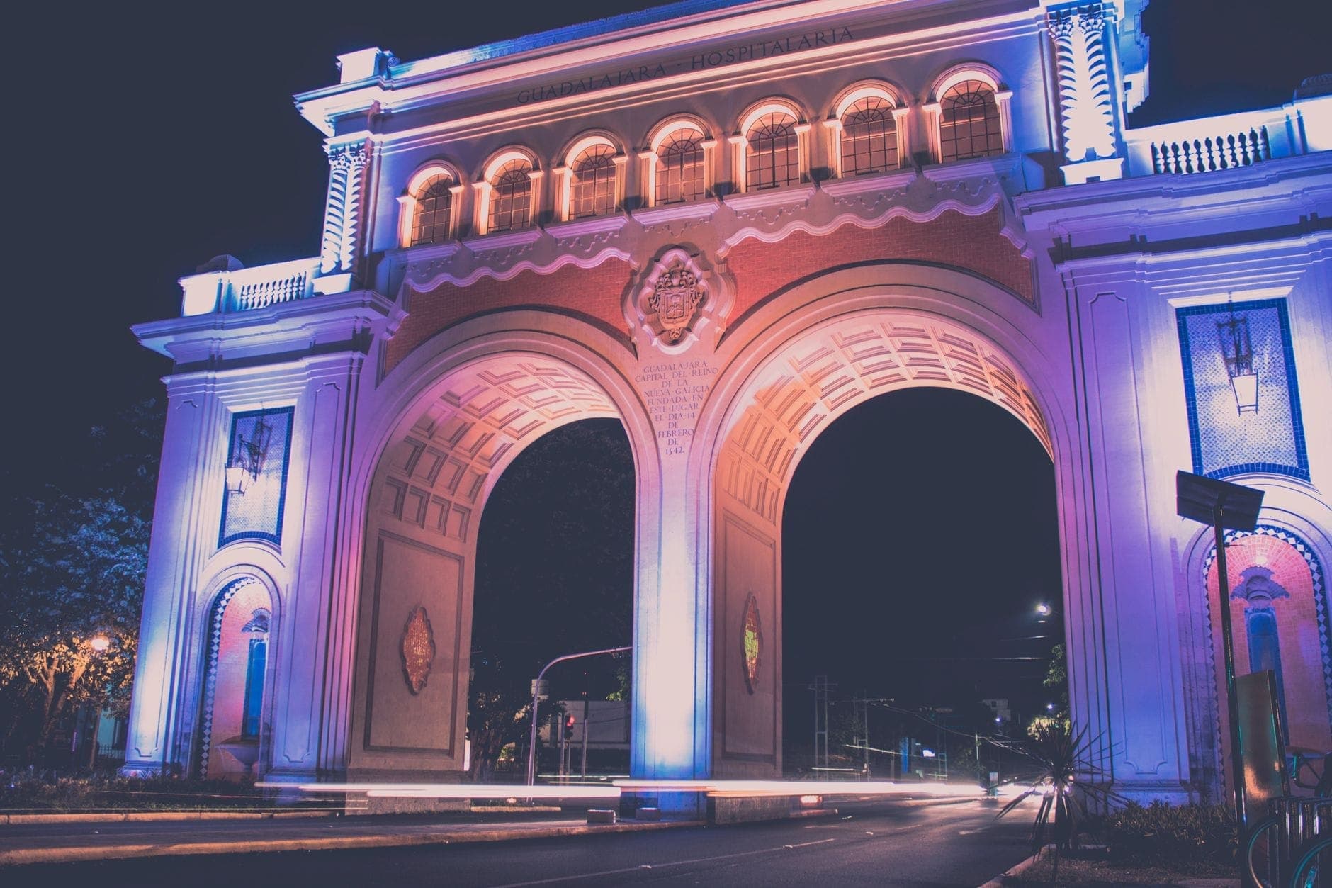
Construction of the Arcos de Guadalajara began in 1939 and was completed in 1942, timed to commemorate the 400th anniversary of Guadalajara's founding. The eclectic design with Californian neocolonial elements, including clean rounded arches and restrained ornamentation, reflects civic architecture popular in mid-20th century Mexico: formal, symmetrical, and intended to project permanence and institutional pride.
At the time of construction, this western stretch of the city was at the edge of significant urban growth. The arches were meant to signal arrival into the modern city, and the name of the surrounding neighborhood, Colonia Arcos Vallarta, has since grown around them. Over the decades, the arches shifted from a literal city gateway into a symbolic one: a reference point locals use for navigation and a frame that appears on postcards, city branding, and murals across Guadalajara.
Visitors interested in the broader architectural heritage of the city will find the arches pair well with a visit to the Guadalajara Cathedral in the historic core, or the ornate interiors of the Teatro Degollado. For a focused overview of how Guadalajara's built environment evolved from colonial to modernist periods, the Guadalajara architecture guide provides useful context.
Visiting the Arcos: What to Expect on the Ground
The arches are visible from a considerable distance along Avenida Vallarta, particularly when approaching from the east. The stone has a warm cream-grey tone that shifts noticeably depending on light conditions. Up close, the scale is more impressive than photographs suggest: standing on the sidewalk and looking up, the arch curves feel generous and confident rather than delicate.
The immediate surroundings are urban and active. Avenida Vallarta carries heavy traffic through much of the day, so the ambient noise level is high: engines, horns, and the rumble of buses form a constant backdrop. This is not a contemplative space the way a park or museum would be. It is a working city street with a landmark in the middle of it.
⚠️ What to skip
The arches stand in the avenue's median. To view them from the center, you will need to cross several lanes of active traffic at a marked crossing point. Exercise caution, especially during rush hours (roughly 7:30–9:30 AM and 5:30–8:00 PM on weekdays), when traffic on Avenida Vallarta is dense and fast-moving.
Most visitors view and photograph the arches from the sidewalk rather than the median. Both perspectives are valid. From the sidewalk, you get the full silhouette of both arches together. From the median, you are closer to the stone itself and can read any inscriptions or details on the facing surfaces. Reaching the median requires attention: use the pedestrian crossings and wait for a complete green cycle before attempting to cross.
Best Time of Day to Visit
The arches are visible around the clock. At night, they are lit from below, and the warm stone takes on a golden glow against the dark sky. Night visits, particularly on weekday evenings after traffic thins around 9:00 PM, offer the most dramatic photography conditions and the safest street crossing windows. The surrounding commercial strip on Avenida Vallarta remains active into the evening with restaurants and cafés.
Early morning on weekdays, around 7:00–8:00 AM, gives you good natural light from the east falling on the arches, but traffic builds quickly. Weekend mornings, especially Sunday before 10:00 AM, combine softer light with significantly reduced vehicle volume. That combination makes Sunday morning the most comfortable time for unhurried photography and for crossing to the median.
Midday light in Guadalajara is harsh for most of the year, washing out the stone's natural color variation. The city sits at about 1,550–1,600 meters elevation, which makes direct sun surprisingly intense even in the cooler months of November through February. A hat and sunscreen are practical for any daytime visit, short as it may be.
💡 Local tip
For the classic postcard composition with both arches framed symmetrically, position yourself on the southern sidewalk and use a moderate zoom. Shooting from street level at the center of the median captures the arch height most effectively but requires a clear break in traffic.
What's Around the Arcos: Making the Most of the Area
The arches are located in the Arcos Vallarta neighborhood, which sits within the broader Chapultepec area of western Guadalajara. Within walking distance, Avenida Chapultepec offers a pedestrian-friendly street lined with cafés, bars, and restaurants, making it a natural next stop after viewing the monument. On weekends, the street hosts an open-air market with local crafts and food vendors.
A few blocks further west lies the Glorieta Minerva, another of Guadalajara's landmark roundabout monuments and often considered the symbolic heart of the western city corridor. Combining both the Arcos and the Minerva in a single walk takes roughly 20–30 minutes on foot and gives a clear sense of how Guadalajara organizes its civic symbols along this axis.
The adjacent Chapultepec neighborhood is one of the city's most walkable areas for food and café culture, particularly in the late morning and early evening. If you are combining the Arcos with a broader exploration of this part of the city, allow two to three hours and comfortable walking shoes.
Practical Information
Admission is free. The monument is on a public avenue and accessible at all hours. No guided tours, entry queues, or timed access windows apply. There is no on-site facility such as a visitor center, restrooms, or souvenir stand.
Getting there by ride-hailing is straightforward: request a drop-off at Av. Ignacio L. Vallarta 2485 in the Arcos Vallarta neighborhood. Apps like Uber and DiDi are active in Guadalajara and work reliably in this part of the city. City buses run along Avenida Vallarta and will stop in the vicinity, though verifying current route numbers through the Mi Transporte network before your visit is advisable, as routes can change.
Street parking exists in the surrounding blocks but fills quickly during business hours. If you are driving, budget additional time to find a spot, particularly on weekday mornings and evenings.
ℹ️ Good to know
Accessibility note: The arches are an outdoor roadside monument. Reaching them involves standard city sidewalks and pedestrian crossings. Specific step-free or wheelchair-accessible route details are not documented in official listings; assess the crossing conditions on arrival based on current traffic patterns.
If you are planning a full day in this part of Guadalajara, the Guadalajara walking tour guide includes itinerary suggestions that connect the Arcos with other landmarks in the western city corridor.
Honest Assessment: Is It Worth the Stop?
The Arcos de Guadalajara are a genuine city symbol, referenced constantly in local visual culture, and they carry real historical weight as a commemorative 20th-century monument. That said, the experience of visiting them is brief and largely photographic. There is no interior to explore, no interpretive signage, and no surrounding plaza to sit in. You are standing on or near a busy urban avenue.
Travelers who have come specifically to understand Guadalajara's identity and visual landscape will find the stop worthwhile. The arches read differently in person than in photos: larger, more grounded in the city fabric. For visitors on a tightly packed schedule, the arches reward a 20-minute detour rather than a dedicated half-day. They are best combined with the surrounding neighborhood rather than visited in isolation.
Travelers who are not particularly interested in civic architecture or city landmarks may find the experience underwhelming, especially compared to the richness of the historic center or the crafts markets of Tlaquepaque. If your priorities are museums, markets, or green space, allocate your time there first and treat the Arcos as an en-route photo opportunity rather than a destination.
Insider Tips
- Sunday mornings before 10:00 AM offer the best combination of low traffic and good eastward light, making median crossing and photography significantly easier than on weekdays.
- Night photography here is underrated. The uplighting turns the stone a deep amber, and traffic headlights streaking past in a long exposure create a dramatic contrast that daytime shots cannot replicate. A tripod helps considerably.
- The neighborhood name Arcos Vallarta is used by drivers and locals as a navigation shorthand for this whole stretch of the avenue. Telling a taxi or ride-hail driver 'Arcos Vallarta' will get you within steps of the monument.
- There is no food or coffee immediately at the monument. Walk two to three blocks south toward Avenida Chapultepec for a range of cafés and street-food options, which makes a natural pre or post-visit stop.
- The arches photograph well from inside a car or bus window if you are passing through, which many visitors do without realizing it. If you are transiting along Avenida Vallarta anyway, it costs nothing to look up.
Who Is Arcos Vallarta (Arcos de Guadalajara) For?
- Architecture and urban history enthusiasts who want to understand how Guadalajara has constructed its civic identity
- Photographers seeking a well-lit monument that rewards both daytime and night shooting
- First-time visitors to Guadalajara building a mental map of the city's western corridor
- Travelers combining a walk along Avenida Chapultepec who want a landmark bookend to the stroll
- Budget travelers: entirely free, requires no advance planning, and takes under 30 minutes
Nearby Attractions
Other things to see while in Chapultepec:
- Avenida Chapultepec
Avenida Chapultepec is a 14-block pedestrian-friendly boulevard in Guadalajara's Colonia Americana that shifts character by the hour. Sunday mornings bring cyclists and skaters under closed traffic conditions; Saturday nights pull in a younger crowd for an outdoor cultural market. On any weekday it functions as a relaxed commercial spine lined with cafes, restaurants, and small shops.
- Glorieta de La Minerva
The Glorieta de La Minerva is the symbolic heart of modern Guadalajara, a monumental 1950s roundabout where a bronze goddess rises about 23 metres above six converging avenues. Free to visit at any hour, it reads differently depending on when you show up: rush-hour spectacle, Sunday cycling route, or golden-hour photography backdrop.
- Parque Revolución (Parque Rojo)
Designed by Luis Barragán and inaugurated in 1929, Parque Revolución sits at the heart of Colonia Americana, just steps from the Juárez light-rail station. Known locally as Parque Rojo for its distinctive red benches and paving, this free public park draws students, commuters, and curious visitors into one of the city's most genuinely local green spaces.