Aït Benhaddou: The Earthen Ksar That Outlasted Empires
Rising from the southern slopes of the High Atlas, the Ksar of Aït Benhaddou is a UNESCO World Heritage Site and one of Morocco's most architecturally striking places. Built from pisé earth and palm wood, this fortified village has stood at the crossroads of trans-Saharan trade for centuries — and remains partly inhabited today.
Quick Facts
- Location
- Ouarzazate Province, Drâa-Tafilalet region — approx. 185–190 km southeast of Marrakech via the Tizi n'Tichka Pass
- Getting There
- No direct public transport. Easiest by organized day tour or private driver from Marrakech; road journey takes roughly 3.5–4 hours each way (around 185–190 km)
- Time Needed
- 2–3 hours on site; full day from Marrakech including travel
- Cost
- No official entrance fee. Local guided visits involve a voluntary contribution. Transport costs vary by option
- Best for
- History enthusiasts, architecture lovers, photographers, film fans, and anyone crossing the Atlas toward the desert
- Official website
- visitaitbenhaddou.com/en/home
What Is Aït Benhaddou?
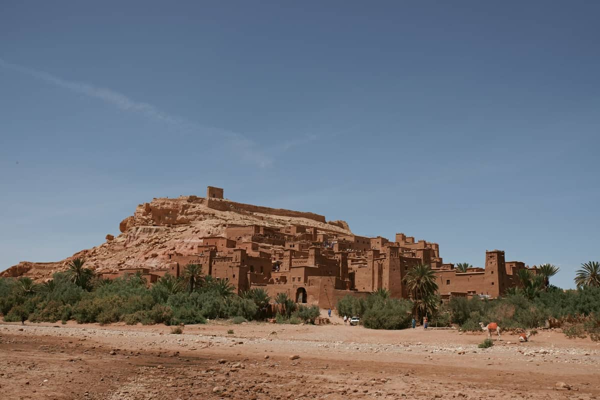
The Ksar of Aït Benhaddou is a fortified earthen village — a ksar — perched on a rocky hillside above the Ounila River, about 25 km northwest of Ouarzazate in southern Morocco. It was inscribed as a UNESCO World Heritage Site in 1987, recognized as one of the finest surviving examples of pre-Saharan earthen architecture in North Africa.
The ksar is a cluster of kasbahs (family tower-houses) built from pisé, a compressed mixture of earth, straw, and water, with walls textured like dried riverbed clay and decorated with geometric relief patterns pressed directly into the surface. The current structures are believed to date from no earlier than the 17th century, though human settlement in this valley is far older. The whole ensemble — towers, granaries, a mosque, and a kasbah — rises in rough tiers up the hillside, culminating in a collapsed but still dramatic fortified crown near the summit.
Crucially, Aït Benhaddou is not a museum or a ruin kept behind barriers. A small number of families continue to live within the ksar, and you walk through their actual village. The earthen walls around you are maintained by hand using traditional methods, because the material is alive in the most literal sense: rain erodes it, sun bakes it, and skilled builders repair it every year.
ℹ️ Good to know
The ksar has no ticket booth and no gate. Access is free, though local residents often offer to act as informal guides for a negotiated contribution. You are not obligated to accept, but a fair payment for a knowledgeable local guide is genuinely worthwhile given how much context is otherwise invisible.
The Experience: What It Feels Like to Arrive
Most visitors arrive from the modern village on the opposite bank of the Ounila River, which is typically dry or shallow enough to cross via stepping stones or a small footbridge. This crossing is part of the experience: you step from the world of tour buses and souvenir stalls directly into an earthen landscape that feels genuinely ancient. The smell on a warm morning is dry dust and baked clay, occasionally cut by the scent of donkey dung and woodsmoke from active households.
Early morning, before the main tour groups arrive around 10:00, the village is at its quietest and most photogenic. The low angle of the sun picks out every ridge and furrow in the earthen walls, casting long shadows that reveal the texture of the architecture in a way that flat midday light completely erases. Roosters, the sound of a plastic bucket being set down on stone, and the distant drone of a vehicle on the Ouarzazate road are typical sounds at this hour.
By mid-morning, the coaches have arrived and the main path through the ksar becomes genuinely crowded. The narrow passageways between buildings force groups to move in single file, and during peak season (October to March, coinciding with cooler temperatures and the high tourism window), you may share the climb with dozens of other visitors simultaneously. If solitude matters to you, arrive before 09:00 or stay past 16:00 when most day-trip groups have departed.
Tickets & tours
Live prices and dates from our booking partner. If you book, we may earn a commission at no extra cost to you.
Private day trip to the Ancient Kasbah of Ait Benhaddou
From 125 €Instant confirmationFree cancellationFull-day tour Marrakech to Kasbah Telouet and Kasbah Ait Ben Hadou
From 40 €Instant confirmationFree cancellationPrivate tour to Ouarzazate and Kasbah Ait Ben Haddou
From 229 €Instant confirmationFree cancellationFull day tour of Ouarzazate from Marrakech
From 51 €Instant confirmationFree cancellation
Architecture and Historical Significance
Aït Benhaddou sat on the historic caravan route connecting the Saharan regions — what old maps called Sudan or the Sahel — to Marrakech via the Drâa Valley and the High Atlas passes. Salt, gold, and enslaved people moved through this valley for centuries. The ksar was not merely a village; it was a fortified waystation, and the thickness of its walls and the height of its towers reflect that defensive function.
The architecture belongs to the broader tradition of southern Moroccan earthen building, characterized by towers with decorative merlons at their summits and blind arcades incised into the façades. The geometric patterns are not purely decorative: they reflect tribal identities, protect against the evil eye according to local belief, and help regulate temperature by creating shadow across the wall surface. Each family's tower was a combined home, grain store, and refuge.
If you want deeper context for how this architectural style fits into Morocco's broader built heritage, the guide to Islamic architecture in Marrakech provides useful background on the design vocabulary you will encounter here and across the region.
What makes Aït Benhaddou unusual among UNESCO sites is that it is not a frozen relic. The earthen buildings require constant maintenance. When you see a freshly patched section of wall with slightly different coloring to the older surface beside it, you are watching a living conservation method that has been used here for centuries. Several families remain resident, and UNESCO has supported restoration programs that prioritize traditional techniques over modern materials.
Film Location: Why the Crowds Come
Aït Benhaddou's global profile owes a great deal to cinema. Its pre-Saharan visual character has made it one of the most filmed locations in North Africa. Productions including Gladiator, Lawrence of Arabia, The Mummy, and the television series Game of Thrones have all used the ksar as a backdrop. A handful of shops in the modern village sell photographs and memorabilia from productions, and some locals will describe which wall or which tower appeared in which film.
The film connection brings visitors who might not otherwise make this journey, which is no bad thing for the local economy. But it also means the site can feel unexpectedly stage-like in places, particularly when you encounter painted signage for a scene that was left behind, or when a shop owner references a Hollywood film rather than the village's actual history. The authentic experience is still very much available — you just have to look past the film-set surface.
💡 Local tip
Photography tip: The best views of the full ksar are from the far bank of the Ounila River, looking northeast. The warm, reddish tones of the earthen walls photograph best in the first and last two hours of daylight. At midday the walls go flat and pale under direct sun.
Getting There from Marrakech
Aït Benhaddou is approximately 185–190 km southeast of Marrakech, reached by road over the High Atlas via the Tizi n'Tichka Pass at around 2,260 meters elevation. The mountain road is well-maintained and paved but winding, and the journey typically takes 3.5 to 4 hours each way by car. There is no direct public transport from Marrakech.
The most common approach is an organized day trip or a multi-day circuit that continues to Ouarzazate, the Drâa Valley, or the Saharan dunes near Merzouga. For planning context, the guide to day trips from Marrakech covers transport options and how to combine this site with other southern destinations.
Private drivers hired in Marrakech are the most flexible option: you control your arrival time and can stop at viewpoints along the Tichka Pass. Shared group tours are cheaper but lock you into a schedule that typically puts you at the ksar between 10:00 and 13:00, which coincides with peak crowding. If you are combining Aït Benhaddou with an onward journey toward the desert, consider stopping here on the way out rather than the way back, so you can arrive early.
⚠️ What to skip
Mountain weather warning: The Tizi n'Tichka Pass can be affected by snow or ice between November and March. Day-trip itineraries are occasionally disrupted by road closures after heavy snowfall. Check road conditions before departure during winter months.
Practical Walkthrough: Navigating the Ksar
Cross the river from the modern village and you enter the ksar through a low gateway. The main path winds upward through the settlement. The lower sections are the most inhabited and have active households: you will hear voices, smell cooking, and occasionally encounter a child or an elder. The upper sections are increasingly ruined and uninhabited, the towers partially collapsed, the rooms open to the sky.
The climb to the top takes 20 to 30 minutes at a relaxed pace, with the path becoming steeper and less defined toward the summit. The reward is a clear view across the Ounila valley floor, the palm grove below, and the bare ochre hills extending south toward Ouarzazate. The surface underfoot is compacted earth and stone throughout, with no handrails on the steeper sections.
Wear shoes with a grip. Smooth-soled sandals on dried earthen steps are a genuine hazard, particularly on the descent. Light layers are advisable: the valley floor can be warm even in winter, but wind picks up at the summit viewpoints. Drinking water is not available inside the ksar itself, so bring your own. Toilets are available in the modern village before you cross the river.
For those combining Aït Benhaddou with a longer southern Morocco journey, the earthen kasbah at Telouet — accessible on the older Tizi n'Telouet road — provides a striking architectural contrast as a largely abandoned Glaoui palace.
Limitations and What to Expect
Aït Benhaddou is architecturally significant and visually extraordinary. It is also, by late morning on any given day between October and March, quite crowded and somewhat commercialized along its main visitor path. Souvenir sellers, informal guides, and requests for payment to photograph residents or their homes are all part of the experience. None of this is unusual for a UNESCO site with this level of recognition, but visitors expecting a solitary communion with ancient history will need to manage their timing carefully.
The site is not well-suited to visitors with limited mobility. The entire ksar is built on a slope with earthen paths, uneven surfaces, and no accessible infrastructure. The modern village and the riverbank view provide a reasonable experience without entering the ksar itself, but the full climb is not feasible for wheelchair users or those who struggle with steep, unpaved terrain.
Travelers who want the drama of Morocco's earthen south without the journey from Marrakech might also consider the Bahia Palace or the Saadian Tombs within the medina, which show a different register of the same broader architectural tradition.
Insider Tips
- Arrive before 09:00 to have the main path nearly to yourself. The light is better, the village is active with morning routines, and you can take photographs without other visitors in the frame. Most tour groups do not reach the site until 10:00 at the earliest.
- If a local resident approaches you as a guide, negotiate a price before you start rather than at the summit. A fair contribution for a 45-minute guided tour is typically in the range of 50–100 MAD, though this varies. An experienced local guide will point out architectural details and film-location history that you would completely miss alone.
- The view from the far bank of the Ounila River — before you cross — is arguably the best single photograph you can take. Many visitors rush straight across and never look back. Spend ten minutes at the riverbank first.
- If you are visiting as part of a Marrakech-to-desert itinerary, stop at Aït Benhaddou on the outward leg (morning) rather than the return. You will catch better light, beat the crowds, and have energy for the climb rather than arriving tired from a long day.
- The modern village across the river has a handful of restaurants serving tagine and harira. The quality is variable, but the setting — looking directly at the ksar while you eat — is hard to beat. Eating here supports the local economy more directly than buying from the souvenir stalls.
Who Is Aït Benhaddou For?
- Architecture and history enthusiasts who want to see living earthen construction techniques up close
- Photographers, especially those who can arrive at golden hour in the early morning
- Travelers on a Marrakech-to-Sahara circuit looking for a compelling midpoint stop
- Film and television fans interested in the locations behind Gladiator, Game of Thrones, and other productions
- Travelers combining the site with the Ouarzazate region, Drâa Valley, or the Telouet Kasbah
Nearby Attractions
Combine your visit with:
- Agafay Desert
Just 30 to 40 kilometres southwest of Marrakech, the Agafay Desert is a rocky plateau of roughly 300 to 400 square kilometres that delivers dramatic open-sky landscapes without a multi-day Sahara expedition. It is not the sand-dune desert many visitors picture, but that distinction is part of its appeal: a raw, mineral terrain framed by the snow-capped peaks of the High Atlas, accessible within an hour of the city.
- Anima Garden
Set along the Ourika road 27 km south of Marrakech, Anima Garden is a three-hectare art-and-nature space created by Austrian artist André Heller. Sculptures, water features, and carefully curated plantings coexist in a setting that feels both otherworldly and deeply rooted in Moroccan landscape. It rewards slow exploration and offers a genuine contrast to the pace of the medina.
- Essaouira
Essaouira is a UNESCO-listed fortified coastal city on Morocco's Atlantic coast, roughly 2.5 to 3 hours from Marrakech by road. Its 18th-century medina, ocean-facing ramparts, and salt-aired souks offer a complete change of pace from the heat and intensity of the inland city. Entry to the medina is free.
- Imlil Village
Perched at roughly 1,740 metres in the High Atlas Mountains, Imlil Village is the main staging point for treks to Jebel Toubkal, North Africa's highest peak. It's a working Amazigh (Berber) mountain community that has gradually absorbed trekkers, guesthouses, and mule handlers into its daily rhythm, without losing the feel of the agricultural valley it was built around.
Planning a trip? Discover personalized activities with the Nomado app.