Torrey Pines State Beach: Wild Coastline Between La Jolla and Del Mar
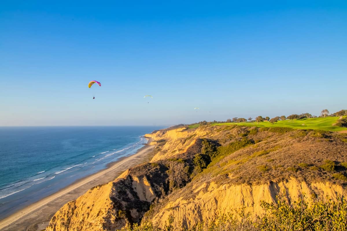
Torrey Pines State Beach is one of the most scenically striking beaches in San Diego County, backed by dramatic sandstone bluffs and protected as part of California's Torrey Pines State Natural Reserve. There's no per-person admission fee, no boardwalk commerce, and no crowds by San Diego standards. What you get instead is a long, wide stretch of sand beneath cliffs that glow amber in the afternoon light.
Quick Facts
- Location
- 12600 North Torrey Pines Road, La Jolla, CA 92037 (between La Jolla and Del Mar)
- Getting There
- Car recommended. From I-5, exit Carmel Valley Road west, then head south on Torrey Pines Road. Limited MTS bus access; check sdmts.com for current routes.
- Time Needed
- 2 to 4 hours for beach only; half-day if combining with reserve trails
- Cost
- No per-person fee. Day-use parking: $15–$20 in the South Beach lot and $10–$25 in the North Beach lot (demand-based pricing). Walk-in and bike access is free.
- Best for
- Solitude seekers, nature lovers, photographers, surfers, hikers
- Official website
- www.parks.ca.gov/?page_id=658
What Makes Torrey Pines State Beach Different
Most San Diego beaches sit behind a row of rental shops, taco stands, and parking meters. Torrey Pines State Beach operates at a different register. The beach runs roughly 1.5 miles along the Pacific coast just north of La Jolla Shores, backed not by development but by towering sandstone bluffs. At the top of those bluffs grows one of the rarest trees in North America: the Torrey pine, a gnarled, salt-adapted species found naturally in only two places in the world, here and on Santa Rosa Island off the Santa Barbara coast.
The combined Torrey Pines State Natural Reserve and State Beach, managed by California State Parks, protects about 2,000 acres of coastal bluffs, lagoon, and shoreline. The beach itself is the lower, accessible coastal strip. Visitors arrive for different reasons: surfers who appreciate a long, uncrowded break; hikers who descend from the reserve trails to walk the sand; families who spread out in the wide North Beach area; and photographers who come specifically for the bluff formations and that amber afternoon light.
ℹ️ Good to know
Access hours are 7:15 AM to sunset daily. There is no per-person admission fee. You pay only for parking, currently $15–$20 per vehicle in the South Beach lot or $10–$25 in the North Beach lot depending on the lot. Walk-in visitors and cyclists enter free.
The Beach Itself: Layout and What to Expect
The beach divides into two general areas. South Beach sits at the base of the reserve bluffs and serves as the primary entry point, with the main parking lot, restrooms, and access to the reserve's trail system above. North Beach, separated by a small lagoon outlet, tends to be slightly wider and calmer in character, with accessible picnic areas, parking, restrooms, rinsing showers, and a beach access ramp for visitors with mobility needs.
The sand here is notably coarse compared to the fine powder at Mission Beach or Coronado. It compacts well when wet, making it comfortable for walking barefoot along the tideline. The bluffs create a partial wind buffer in some sections, which can make conditions feel warmer and more sheltered than exposed beaches to the south. Kelp washes ashore regularly, especially after winter swells, carrying with it the briny, mineral smell that marks this as a more raw stretch of California coast.
Swimming is possible but requires attention. There are no permanent lifeguard towers along this stretch in the same density as Mission Beach or Pacific Beach, and rip currents can develop, particularly near the lagoon outlet at North Beach. Check current conditions before entering the water.
⚠️ What to skip
Rip currents can be present near the Los Penasquitos Lagoon outlet at the north end of the beach. Lifeguard coverage may not be year-round or staffed at every section. Check flag conditions and local surf reports before swimming.
How the Experience Changes Through the Day
Early morning is the best time to understand why this place matters. By 7:30 AM on a weekday, the parking lot may hold only a handful of cars. The bluffs cast long shadows across the sand. Shorebirds, including Western sandpipers and willets, probe the wet tideline without disturbance. The lagoon at the north end reflects the pale sky. The light is soft and directional, and the Torrey pines visible above the bluff edge look more dramatic than at any other hour.
Midday from late June through August brings the coastal marine layer, locally called the June Gloom, which can linger well past noon, keeping temperatures in the low 60s Fahrenheit even in summer. This is not necessarily a problem for beach use, but if you are coming for photography or warmth, plan accordingly. Crowds at midday in summer are present but never approach the compression of Pacific Beach or Mission Beach, partly because the parking lot capacity limits throughput naturally.
Late afternoon, roughly 3 PM to an hour before sunset, is when the bluffs turn their most photogenic. The sandstone catches the western light and the color shifts from pale tan to deep ochre and rust. This window also sees a second surge of visitors arriving after work or checking in from nearby hotels. On clear days in September and October, when the marine layer has typically retreated, late afternoon here is exceptional.
The Torrey Pine: Context for the Bluffs Above
The Torrey pine (Pinus torreyana) is the rarest pine species in the United States. It survives in conditions most trees cannot: thin, nutrient-poor sandstone soils, salt spray, and seasonal drought. The trees growing above this beach are wild individuals, not planted specimens. Their silhouettes, contorted by decades of coastal wind, are part of what makes the view from the beach looking north and east toward the bluffs so distinctive.
If you want to walk among the trees rather than simply view them from below, the Torrey Pines State Natural Reserve trail network begins at the South Beach parking area and ascends the bluffs. Trails like the Razor Point and Yucca Point loops offer close views of both the trees and the beach below. Most are moderate in difficulty and short in length, with a few interpretive signs on the geology and ecology. Combining a reserve hike with beach time below is the most complete way to experience this protected landscape.
The reserve’s conservation story began in the early 20th century, and the area was later brought under state protection as a state park and natural reserve. That context adds something to the experience that most beaches cannot offer: you are standing in a place that was deliberately protected over a century ago specifically because of what grows on the cliffs above you. The decision to preserve this stretch was driven by recognition that the Torrey pine population here was the last significant coastal wild stand.
Getting There and Parking Without Frustration
The most direct route by car from I-5 is to exit at Carmel Valley Road, head west to the coast, then turn south on North Torrey Pines Road. The South Beach parking lot entrance is on the right. The lot fills early on summer weekends, often by 9 AM. North Beach has a separate, smaller lot accessed a short distance north on Torrey Pines Road.
Walk-in access is free and worth knowing about. Visitors who park along surface streets in nearby Del Mar or use rideshare apps (Uber and Lyft operate throughout San Diego) can walk in without paying the parking fee. This also removes the stress of lot availability. For broader context on moving around the city, the getting around San Diego guide covers transit options including MTS bus routes that serve the coastal corridor.
Cyclists can access the beach from the Torrey Pines Road shoulder and from nearby roads in the area. The grade descending to the beach from the north is gentle. From La Jolla to the south, the route involves more elevation change along the reserve road.
Photography, Surfing, and What Else to Do Here
Surf at Torrey Pines tends to be most consistent from October through April when northwest swells reach the beach without significant reef or point interference. The beach break can produce clean, medium-size waves that attract intermediate surfers. Beginners may find conditions less forgiving than at La Jolla Shores to the south, which has a gentler shore break.
For photographers, the primary subjects are the bluff geometry, the Torrey pine silhouettes above the ridgeline, and the surf patterns against the pale sand. The North Beach section also sits near the Los Penasquitos Lagoon State Marine Conservation Area, where shorebirds and occasionally harbor seals can be observed. For wider coastal photography across San Diego, the best views in San Diego guide includes several vantage points that complement a visit here.
Beachcombing after winter storms can be productive. The combination of west-facing beach exposure and kelp-bearing currents means unusual shells and other debris can occasionally appear after significant swell events. Tidepooling is limited directly at Torrey Pines compared to La Jolla Cove or Cabrillo, but the north end near the lagoon outlet can expose small rocky zones at low tide.
Who This Beach Suits and Who It Does Not
Torrey Pines State Beach works best for visitors who prioritize space, scenery, and natural setting over amenities and energy. If you are looking for the social scene, the beach volleyball, the food trucks, and the boardwalk pedestrian traffic, this is not the right choice. Pacific Beach or Mission Beach boardwalk will serve those priorities better.
Visitors with young children should note that the beach is wide and open, which is positive, but amenities are limited. There are no food concessions at the beach itself, so bring everything you need, including water, snacks, and sun protection. The walk from the parking area to the sand is short and manageable, but the terrain is sand and gravel rather than a paved promenade.
For visitors building a broader San Diego itinerary, Torrey Pines pairs well with a morning visit to the Birch Aquarium at Scripps in nearby La Jolla, or with a stop at La Jolla for lunch before or after the beach. The best beaches in San Diego guide places Torrey Pines in the context of other coastal options across the city.
Insider Tips
- Arrive before 8 AM on summer weekends to guarantee parking without circling. The lot fills fast, and unlike many San Diego beaches, there is no easy overflow street parking nearby.
- Walk-in access is free. Dropping someone at the North Beach entrance while another person parks on the Del Mar side is a legitimate strategy that saves both the parking fee and the frustration.
- The concrete path connecting the South Beach parking lot to the beach passes below the bluff face. Stop and look up here before heading to the sand. The layered sediment bands in the cliff are visually striking up close and give a sense of the geological age of this coastline.
- September and October are objectively the best months to visit: summer crowds have thinned, the marine layer has retreated, afternoon temperatures reach the low-to-mid 70s Fahrenheit, and the low-angle light in the late afternoon on the bluffs is superb.
- Dogs are not permitted on the beach or in the reserve. This is a state park regulation, not a recommendation, and it is enforced.
Who Is Torrey Pines State Beach For?
- Solitude seekers who want a San Diego beach without commercial noise or dense crowds
- Hikers who want to combine a coastal trail with time on the sand in a single visit
- Photographers targeting dramatic coastal geology and rare native flora
- Surfers looking for a beach break with room to spread out during fall and winter swells
- Nature-focused travelers who want ecological context alongside a beach experience
Nearby Attractions
Combine your visit with:
- Anza-Borrego Desert State Park
Anza-Borrego Desert State Park stretches across more than 600,000 acres of Colorado Desert in eastern San Diego County, making it one of the largest state parks in the United States. From spring wildflower carpets to ancient slot canyons and some of the darkest skies in Southern California, it rewards visitors who plan carefully and respect the terrain.
- Border Field State Park
Border Field State Park occupies the southwestern corner of the continental United States, where Pacific surf meets the U.S.–Mexico border fence. It offers coastal wetlands, a historic marble boundary monument, and views toward Friendship Park — the U.S.-side gathering space has been closed since 2020, so confirm current access before you go.
- Cedar Creek Falls
Cedar Creek Falls is a backcountry waterfall deep inside Cleveland National Forest, reached by a strenuous 6-mile round-trip hike from Ramona. A mandatory day-use permit keeps crowds manageable, but you'll earn every step of the descent into this rugged gorge. This guide covers the permit process, trail conditions, safety warnings, and what to realistically expect.
- Chicano Park
Chicano Park is a National Historic Landmark tucked beneath the San Diego–Coronado Bridge in Barrio Logan, where more than 80 monumental murals cover the concrete pillars of a freeway overpass. Free to enter and open daily, it is one of the most culturally layered outdoor spaces in the American Southwest.