Rouge National Urban Park: Canada's First National Urban Park
Spanning over 79 square kilometres across Toronto's eastern edge, Rouge National Urban Park is Canada's first national urban park. Free to enter and open every day of the year, it packs forests, wetlands, agricultural land, beaches, and over 1,700 species of plants and animals into a landscape that feels genuinely removed from the city around it.
Quick Facts
- Location
- Scarborough, Toronto (also spanning Markham, Pickering, Uxbridge and Whitchurch-Stouffville)
- Getting There
- TTC Bus routes serve the Zoo Road area; check TTC trip planner for current service. By car: approximately 30 minutes from downtown Toronto.
- Time Needed
- 2 hours minimum for a short trail walk; full day for serious hiking or combining multiple sections
- Cost
- Free. No day-use fee. Parking lots open 7:30 am to 9:00 pm daily.
- Best for
- Hikers, birders, families with older children, photographers, and anyone needing wilderness without leaving the city
- Official website
- parks.canada.ca/pn-np/on/rouge
What Rouge National Urban Park Actually Is
Rouge National Urban Park is not a manicured city park with paved paths and park benches. It is a genuine wilderness preserve, covering over 79 square kilometres, where forest canopy closes over the trail, coyotes move through the underbrush at dusk, and the sound of the Rouge River drowns out any traffic noise. For a park that sits inside one of Canada's largest metropolitan areas, that contrast is striking and not easy to forget.
Established on May 15, 2015 under the Rouge National Urban Park Act, it became Canada's first national urban park and remains its only one. That designation matters practically: it falls under Parks Canada's mandate, meaning conservation standards are stronger than those applied to most municipal greenspace. The park protects ecosystems spanning the Oak Ridges Moraine to the Lake Ontario shoreline, along with working farms that have been cultivating this land for generations. The result is a patchwork of forest, wetland, valley, agricultural field, and beach, all within roughly 30 minutes of downtown Toronto.
For context on how Rouge fits into Toronto's wider outdoor landscape, the best parks in Toronto guide covers the full range from downtown greenspace to wilder escapes. Rouge sits firmly at the wild end of that spectrum.
ℹ️ Good to know
Admission to Rouge National Urban Park is free every day of the year for day use. There are no tickets, no passes, and no booking requirements for general trail access.
The Landscape: What You're Walking Into
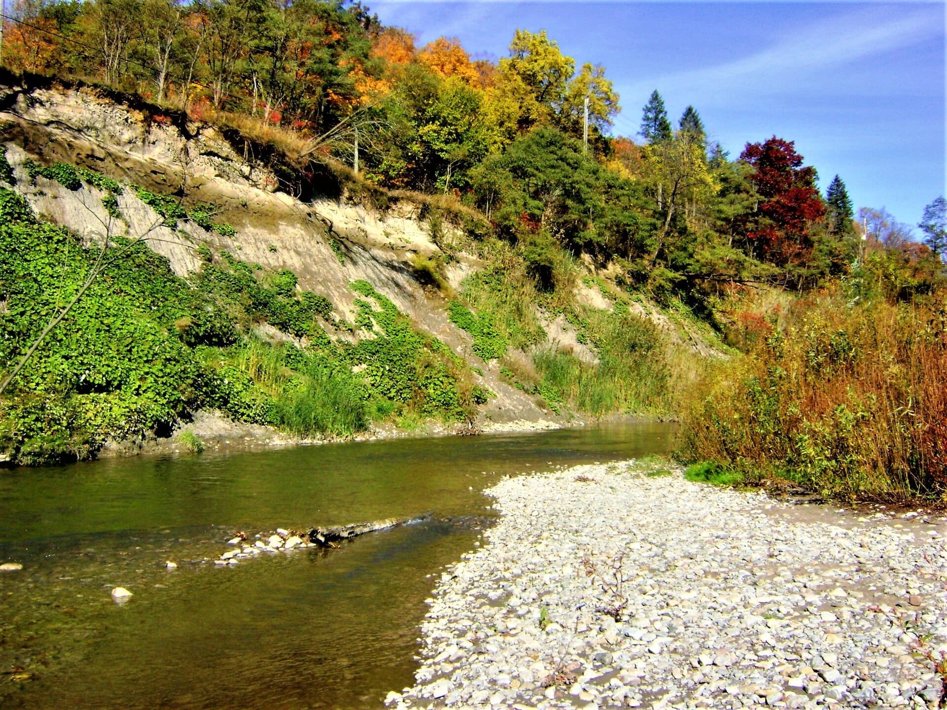
The park's terrain shifts noticeably as you move through it. Near the lake, the land is flat and the air smells of damp soil and marsh vegetation. Moving north into the Rouge River valley, the trail drops into a deeply carved ravine where exposed clay banks and tangled root systems make the path feel more remote than its proximity to the city would suggest. On sunny mornings, light filters through the canopy at angles that turn the valley floor almost golden.
The park harbors more than 1,700 species, including at-risk species such as the Bobolink and the Barn Swallow. Birding is particularly productive in the wetland sections and along the river corridor, where you might hear Red-winged Blackbirds, Belted Kingfishers, and Wood Ducks without having to walk more than a few hundred metres from a trailhead. The presence of working farms alongside wildlife corridors is unusual for a national park and reflects a deliberate conservation approach that treats agricultural heritage as part of the landscape's identity.
The park borders the Toronto Zoo, which shares the Zoo Road access corridor. The two are separate operations but sit back to back, and combining both in a single day is a practical option for families.
Tickets & tours
Hand-picked options from our booking partner. Prices are indicative; availability and final rates are confirmed when you complete your booking.
Toronto Old Town: Dark Side Exploration Game and Tour
From 12 €Instant confirmationFree cancellationLEGOLAND Discovery Centre Toronto tickets
From 16 €Instant confirmationFree cancellationToronto 'Little Canada' entrance tickets
From 27 €Instant confirmationFree cancellationNiagara Falls evening tour with boat, dinner and Illumination Tower
From 77 €Instant confirmationFree cancellation
How the Experience Changes by Time of Day and Season
Early morning, roughly between 7 and 9 am, is when the park shows its best face. Mist rises off the river in cooler months, wildlife is most active, and the parking lots are quiet. The Rouge Valley Trail in particular feels entirely different at 7 am than it does at noon on a summer Saturday, when families and joggers fill the lower sections near Zoo Road.
Late afternoon on weekdays is another reliable quiet window. By 5 pm, most families have left, and the trails take on a calmer character. The light is better for photography during this hour too, especially in autumn when the maple and oak canopy turns amber and red above the river valley.
Seasonally, autumn (late September through October) is the most visually dramatic time to visit. Spring brings substantial mud on unpaved trails but also the year's most active birding. Summer weekends are the busiest, and some parking areas reach capacity by mid-morning. Winter visits are entirely feasible: snowfall muffles the landscape, animal tracks become readable in fresh snow, and the crowds nearly disappear. Dress in layers and expect ice on uneven terrain.
⚠️ What to skip
Parking lots close at approximately 9:00 pm daily and may close earlier or temporarily during severe weather. If you arrive by car, note the posted closure time before you start a longer trail.
Trails and Access Points: Where to Start
The Zoo Road Day Use Area, near the Toronto Zoo's main entrance, is the most accessible starting point and the one most visitors use first. From here you can connect to the Rouge Valley Trail, which follows the river south toward Lake Ontario and offers some of the park's most varied scenery within a manageable distance. The trail surface varies: some sections are well-maintained gravel paths, others are raw earth that becomes slippery after rain.
More experienced hikers tend to explore the northern sections of the park, which extend into Markham and Uxbridge and receive far less foot traffic. These areas require a car and more careful navigation, but the payoff is genuine solitude in a landscape that feels nothing like the urban fringe. Parks Canada's official website provides a downloadable trail map that is worth reviewing before you visit, particularly if you plan to venture beyond the main Zoo Road corridor.
The Glen Eagles area and the Mast Trail offer different terrain from the valley floor, including elevated viewpoints and denser forest. Footwear matters: proper hiking boots with ankle support make a real difference on the valley slopes, especially after wet weather. Sandals and flat-soled sneakers work fine for the paved sections near the day-use areas but become a liability on the steeper trail descents.
If Rouge sparks interest in broader ravine hiking across the city, the Toronto ravines hiking guide covers the full network of green corridors that run through the urban grid.
Getting There Without a Car
Reaching Rouge by public transit requires some planning but is possible. TTC bus routes connect the Zoo Road area to the subway network; check the TTC trip planner for current route numbers and service frequency, as these change periodically. The journey from downtown Toronto takes roughly 45 to 60 minutes by transit. GO Transit also provides regional service to nearby stations in Markham and Scarborough, which can work as an alternative starting point depending on which section of the park you intend to explore.
By car, the Zoo Road access point is approximately 30 minutes from downtown Toronto via Highway 401. On summer and autumn weekends, the parking lots near the main trailheads fill quickly, sometimes by 9:30 am. Arriving before 8 am or after 2 pm generally avoids the worst of it.
💡 Local tip
If you're driving from central Toronto on a weekend, the Highway 401 eastbound approach can back up near the Meadowvale Road exit. Allow extra time or check traffic before leaving.
Who This Park Suits, and Who It Doesn't
Rouge works well for anyone comfortable spending two to four hours on unpaved trail with minimal facilities. Birders, trail runners, families with children old enough to manage uneven terrain, and photographers all tend to get genuine value from the visit. The park's scale and ecological diversity also make it interesting for anyone with a background in natural history; interpretive signage at the main access points provides solid context on the watershed and the at-risk species present.
Visitors expecting manicured paths, on-site food service, or the kind of polished infrastructure associated with urban parks in the city centre will be disappointed. There are washrooms at the main day-use areas, but services beyond that are limited. Young children and anyone with limited mobility will find the trail network challenging outside the flat sections near the parking areas; accessibility varies significantly across the park, and it is worth checking Parks Canada's accessibility information for specific areas before planning a trip around them.
For visitors combining Rouge with the broader Scarborough area, the nearby Scarborough Bluffs offer a completely different landscape: dramatic lake-facing cliffs rather than river valley forest, and worth pairing on the same day if you have a car.
Photography and Practical Details
The Rouge Valley's north-south orientation means that morning light enters the valley from the east and strikes the exposed clay banks and river surface directly, which is useful for photography between roughly 7 and 10 am. The autumn canopy reflects onto the river in sections where the trail runs along the water's edge, creating the kind of image that doesn't require any technical skill to execute well.
Bring more water than you think you need. There are no water refill stations on the trails themselves. A basic first aid kit is worth carrying on longer hikes in the northern sections. Mobile coverage drops off in the deeper valley sections, so downloading the trail map offline before you arrive is a practical precaution.
If you're planning a fuller itinerary around Toronto's natural and cultural sites, the 3 days in Toronto guide can help you structure how Rouge fits alongside other priorities.
Insider Tips
- The section of the Rouge Valley Trail between Zoo Road and the Glen Eagles area sees a fraction of the traffic of the main day-use zone. Walk past the first parking lot and continue along the river for noticeably fewer people after the first 15 minutes.
- In late April and May, the beaver pond sections near the lower valley are active at dusk. Arriving around 6 pm and standing quietly for 10 minutes near the water's edge often produces sightings that busier midday visits won't deliver.
- The park's working farm sections, visible from certain trail corridors, provide a rare visual reminder of the Carolinian agricultural landscape that predated the city. Stop at the interpretive panels near Zoo Road to understand the land tenure history before you walk.
- If the Zoo Road parking lot is full on a weekend morning, the secondary access points in Markham (such as the Twyn Rivers Drive area) typically have space available and connect to the same trail network.
- Wear long pants regardless of season. The trail edges are brushy in summer and tick awareness is warranted; Parks Canada's visitor information includes guidance on tick prevention for this reason.
Who Is Rouge National Urban Park For?
- Trail hikers and day-trippers wanting genuine forest and river landscape within the Toronto city boundary
- Birders targeting species such as Belted Kingfisher, Wood Duck, Bobolink, and Barn Swallow in functioning wetland and agricultural habitat
- Families with older children (8+) ready for uneven terrain and a half-day outdoor commitment
- Photographers seeking autumn foliage, river-valley light, and wildlife without driving hours from the city
- Nature-focused visitors who want to understand the ecological and agricultural history of Toronto's eastern fringe
Nearby Attractions
Other things to see while in Scarborough:
- Bluffer's Park & Beach
Bluffer's Park and Beach sits at the base of the Scarborough Bluffs, a towering 15-kilometre stretch of cliffs that rise over 90 metres above Lake Ontario. It is one of Toronto's most geologically dramatic landscapes, offering a free sandy beach, calm harbour waters, and jaw-dropping cliff views that feel far removed from the city above.
- Guild Park and Gardens
Guild Park and Gardens in Scarborough preserves dozens of architectural fragments salvaged from demolished Toronto buildings, set across a blufftop park overlooking Lake Ontario. Free to enter year-round, it combines genuine heritage interest with peaceful walking paths and one of the city's more unusual green spaces.
- Scarborough Bluffs
Stretching 15 kilometres along the eastern shore of Lake Ontario, the Scarborough Bluffs are one of Toronto's most striking natural features. Formed from glacial sediment deposited over 12,000 years ago, the chalk-white and ochre cliffs rise more than 90 metres above the water. Entry is free, the views are genuinely impressive, and the contrast with the downtown skyline couldn't be greater.
- Toronto Zoo
Set on 710 acres beside Rouge National Urban Park in Scarborough, the Toronto Zoo is the largest zoo in Canada, home to over 5,000 animals across 500 species. It rewards a full day of exploration, but the sheer scale demands some planning.