Monte Limbara: Gallura's Granite Massif and the Roof of Northern Sardinia
Monte Limbara is the dominant peak of Gallura in northeastern Sardinia, a broad granite massif reaching 1,362 metres at Punta Sa Berritta. Covered in cork oak and holm oak forest, laced with hiking trails, and ringed by sweeping views from the Tyrrhenian Sea to the mountains of the interior, it offers something different from the coastal Sardinia most visitors know.
Quick Facts
- Location
- SP51, Tempio Pausania, Gallura, northeastern Sardinia
- Getting There
- Car only (no public transport). From Tempio Pausania: SS 392 toward Oschiri; access point at Curadoreddu, km 7. From the south: SS 597 Sassari–Olbia then SP 62 toward Berchidda.
- Time Needed
- Half day minimum; full day for serious hiking. The road up to the summit area takes around 20–30 minutes from Tempio Pausania.
- Cost
- Free to access. Some specialist areas (mouflon reserve at Curadoreddu, Butterfly Park) require reservations and may charge fees — confirm directly with managing bodies.
- Best for
- Hikers, nature photographers, travellers looking for a break from the coast, birdwatchers, and anyone curious about Gallura's forested interior.
- Official website
- www.sardegnaturismo.it/en/explore/monte-limbara
What Monte Limbara Actually Is
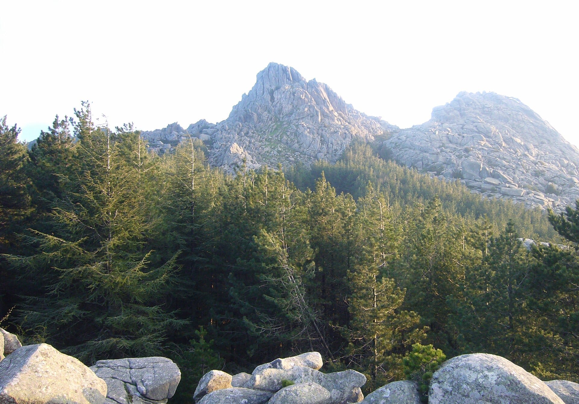
Monte Limbara is not a single pointed peak but a granite massif, about 120 kilometres in extent and covering around 6,680 hectares in the heart of Gallura. Its highest point, Punta Sa Berritta, tops out at 1,362 metres above sea level. A second significant summit, Balistreri, sits close by. The massif straddles four municipalities: Tempio Pausania on the north and northwest slopes, Calangianus to the east, Berchidda to the south, and Oschiri to the southwest.
From below, the massif reads as a dark green wall rising abruptly from Gallura's rolling granite plateaux. Up close, it is a landscape of exposed rock outcrops, dense cork oak and holm oak forest, open heath, and small streams that survive even in summer in the deeper gullies. Telecommunications towers crowd the summit ridge, which is a minor visual disappointment, but the scale of the landscape absorbs them once you are actually walking.
ℹ️ Good to know
Monte Limbara is freely accessible year-round. There are no gates, no ticket booths, and no booking required for general hiking. The road from Tempio Pausania to the summit area is paved and generally passable in a standard car in good conditions.
The Historical and Cultural Weight of the Mountain
The Ancient Romans called this zone *limes Balares*, because it marked the border between Gallura and the territories of the Balares, an indigenous Sardinian people. The name Monte Limbara likely derives from this same Latin root, making the mountain itself a kind of cartographic memory: a line drawn in granite between two ancient worlds.
Near the Balistreri peak stands the small church of Madonna della Neve, Our Lady of the Snow. It is a building that feels entirely of its place: spare, white, set against rough granite, with nothing around it to soften the sky. Local pilgrims have long made their way up here, and the church remains an active site of devotion rather than a heritage exhibit.
Gallura has always been the granite region of Sardinia, distinct in geology, language (Gallurese, a variety of Italian closer to Corsican than to standard Sardinian), and culture. Monte Limbara sits at the geographical centre of this identity. Exploring it alongside nearby villages like Tempio Pausania gives context that a beach itinerary simply cannot. For a broader picture of the region, the Gallura travel guide is a useful starting point.
Tickets & tours
Hand-picked options from our booking partner. Prices are indicative; availability and final rates are confirmed when you complete your booking.
Supramonte Full-Day Jeep Off-Roading and Hiking Tour in Dorgali
From 95 €Instant confirmationFree cancellationVineyard Guided Tour and 7 Wine Tasting in Palau
From 84 €Instant confirmationFree cancellationFull-Day Sailboat Tour in La Maddalena Archipelago from Cannigione
From 112 €Instant confirmationFree cancellationHiking excursion to the Devil's Saddle
From 35 €Instant confirmationFree cancellation
What the Visit Feels Like: Time of Day and Seasons
In the early morning, particularly between June and September, the summit is often clear while the coastal lowlands sit under a thin haze. The air smells of resin and damp granite, and the only sounds are wind through the cork oaks and, if you are lucky, the call of raptors that nest in the rockfaces. By mid-morning in summer, day-trippers arrive from Tempio Pausania and the coast, but the massif is large enough that you rarely feel crowded.
By midday in July and August, temperatures on the exposed summit ridge can climb significantly. The granite absorbs heat and radiates it back. Start any serious hike by 8 a.m. in summer, carry at least two litres of water per person, and plan to be off the exposed ridgeline by early afternoon. The forested lower slopes are far more comfortable during the heat of the day.
Autumn is arguably the finest season on Monte Limbara. From late September through November, the light turns low and golden, the forest floor accumulates fallen cork bark and acorns, and the probability of cloud and mist rolling in from the north adds atmosphere without usually ruining visibility. Temperatures are mild enough for comfortable hiking all day. Spring (April to early June) is the other strong choice: the undergrowth is flowering, water runs in the gullies, and migrating birds pass through.
Winter brings a genuine cold here, occasionally snow on the higher peaks, and sometimes ice on the access road. The Madonna della Neve church gets its own logic in this context. Winter visits are possible but require checking road conditions before departure, and the summit area can be in cloud for days at a stretch.
⚠️ What to skip
The summit road can be icy or temporarily closed after heavy rain or snow between November and March. Check local conditions via Tempio Pausania's municipal channels before making the drive in winter.
Hiking and Trails: What to Expect
The trail network on Monte Limbara ranges from easy forest walks along forest roads to more demanding ridge routes that require sure footing on granite. The most popular route to Punta Sa Berritta begins from the road near the summit, making it accessible to reasonably fit walkers without any technical equipment. The ascent from the car park to the peak takes about an hour at a moderate pace.
The trail up Monte La Trona gives a longer circuit option across the massif. The terrain underfoot is characteristic Gallura granite: smooth and warm to the touch in sun, slippery when wet. Proper hiking shoes with grip are important. Trainers are inadequate on wet rock.
For those interested in combining Monte Limbara with a wider programme of Sardinian mountain walking, the hiking in Sardinia guide covers trail grades, gear requirements, and logistics across the island.
- Wear ankle-supporting hiking boots with grip, not trainers.
- Carry a minimum of 1.5–2 litres of water per person in summer. There are no reliable water sources on the upper slopes.
- A wind layer is useful at the summit even in summer — the ridge can be cold and exposed.
- Download an offline map before you go. Mobile signal on the upper massif is variable.
- The massif is large and forested; it is possible to lose trail markings. Stick to established paths unless experienced in off-trail navigation.
Flora, Fauna, and the Natural Character of the Massif
The lower and middle slopes of Monte Limbara are dominated by cork oak forest, Gallura's most economically and ecologically significant tree. Cork harvesting has shaped this landscape for centuries, and you will see the distinctive rust-red lower trunks of recently stripped trees throughout the forest. Higher up, the vegetation transitions to holm oak, heath, and then bare granite at the summit.
The Curadoreddu area on the northern approach hosts a mouflon reserve. The Sardinian mouflon is native to the island and considered a symbol of the Sardinian uplands. Visiting the reserve requires advance reservation through the managing forestry bodies. A Butterfly Park on the southern slopes is another specialist draw, though like the mouflon reserve it operates with its own access conditions that require independent confirmation.
Bird life across the massif includes raptors, including the Bonelli's eagle, which has historically nested in this part of Gallura. The forests hold woodpeckers, treecreepers, and crossbills. For casual visitors, the mix of open granite and dense forest makes birdwatching productive without requiring any specialist effort.
Getting There and Practicalities
A car is effectively required. There is no scheduled public transport to Monte Limbara's upper slopes. From Tempio Pausania, follow the SS 392 toward Oschiri; the forestry offices and northern access at Curadoreddu are at kilometre 7. The road continues to the summit area. From the south, approach via the SS 597 Sassari–Olbia road, then SP 62 toward Berchidda.
Tempio Pausania, about 14 kilometres to the northwest, is the natural base. It is a composed granite town with a historic centre, decent food options, and accommodation including the Hotel Vallicciola on the Limbara slopes itself, a useful option for anyone wanting access. Olbia, with its airport (IATA: OLB), is roughly 50 kilometres to the east, making Monte Limbara a logical day trip for visitors based on the Costa Smeralda coast.
If you are building an itinerary that combines Limbara with Gallura's coast and interior, the Sardinia road trip guide covers routing options that work well for northeastern Sardinia.
💡 Local tip
Fuel up in Tempio Pausania before heading up. There are no petrol stations on the mountain, and the closest options on the Berchidda side require backtracking several kilometres.
Photography, Views, and What to Frame
The summit panorama from Punta Sa Berritta on a clear day takes in the coast of Gallura, the silhouettes of the La Maddalena archipelago, Corsica to the north, and the mountains of the interior stretching south. Early morning in autumn or late spring gives the cleanest light and the greatest chance of finding the coast clear of haze.
For photographers, the most interesting compositions are not at the summit but in the cork oak forest below, where light filters between orange-barked trunks onto grey granite boulders. The church of Madonna della Neve against a stormy sky is one of the more compelling frames on the mountain. Those visiting the broader region might also note that the granite formations at Capo Testa offer related photographic character in a coastal setting.
Drone use in Italian mountain areas is subject to national civil aviation authority (ENAC) regulations. Check ENAC requirements and local restrictions before flying.
Who This Is Not For
Monte Limbara is not a well-packaged tourist attraction with a café at the top and a clear narrative. Visitors expecting easy access, facilities, or a polished experience will be frustrated. The telecommunications infrastructure at the summit is visually jarring and impossible to ignore. People who struggle with uneven terrain, who require wheelchair access, or who are not comfortable with unmarked forest driving will find the experience limited. In peak summer heat, the exposed upper slopes are uncomfortable between 11 a.m. and 4 p.m., and the payoff does not justify the discomfort if you cannot start early.
If your primary interest is Sardinia's archaeology or nuragic heritage, Monte Limbara offers relatively little in comparison with sites such as those documented in the broader guide to Sardinian nuragic culture. The mountain's value is its landscape, its scale, and its contrast with the coastal experience most visitors have.
Insider Tips
- The northern access road through Curadoreddu is a scenic approach. If you are coming from Tempio Pausania, take this route up and descend via Berchidda for a full cross-massif circuit by car.
- The church of Madonna della Neve is often locked but the setting around it, with its views north toward the coast, rewards the walk to Balistreri even if the building itself is closed.
- September and October weekday mornings are consistently the quietest period. Italian domestic tourists often leave after Ferragosto (15 August), and the trails are quieter.
- Cork oak trees that have recently been stripped show vivid red-orange trunks that photograph beautifully in low morning light. Look for recently harvested trees in the Curadoreddu forest section, where harvesting has shaped the landscape.
- If you are based in Olbia or the Costa Smeralda and have a free half day, Monte Limbara is far enough inland to feel like a completely different Sardinia. The drive from Olbia through the cork landscape of the Gallura interior is itself worthwhile — keep time for Tempio Pausania's old centre on the way back.
Who Is Monte Limbara For?
- Hikers and trail runners looking for altitude and granite terrain in northern Sardinia
- Nature photographers wanting cork oak forest, granite boulders, and summit panoramas in a single location
- Travellers on a multi-day Gallura or Sardinia road trip who want interior contrast to the coastal route
- Birdwatchers, particularly those hoping to see raptors on the massif
- Anyone visiting in shoulder season (May or October) who wants a full-day outdoor excursion away from the beach crowds
Nearby Attractions
Other things to see while in Gallura:
- Basilica di San Simplicio (Olbia)
The Basilica di San Simplicio is the oldest surviving building in Olbia and one of the finest Romanesque churches in Sardinia. Built between the late 11th and mid-12th centuries on a site with origins in a Roman necropolis and a Palaeo-Christian church, it offers a rare, unhurried encounter with pre-medieval Gallura — around ten minutes' walk from the ferry port crowds.
- Capo Testa
Capo Testa is a rugged granite promontory jutting into the Strait of Bonifacio near Santa Teresa Gallura, in Sardinia's far north. The headland is free to visit and rewards exploration with wind-sculpted rock formations, secluded sea pools, and the eerily beautiful Valle della Luna. It is one of northern Sardinia's most distinctive natural landscapes.
- Coddu Vecchiu Giants' Tomb (Arzachena)
The Giants' Tomb of Coddu Vecchiu is one of Sardinia's best-preserved Nuragic funerary monuments, featuring a roughly 4-metre granite entrance stele that has stood in the Gallura countryside for roughly 4,000 years. Located about 10 km from the Gulf of Arzachena, it offers a absorbing encounter with the island's prehistoric past in under an hour.
- Costa Paradiso
Costa Paradiso is a striking stretch of northern Sardinian coastline where ancient red and orange granite cliffs drop into transparent turquoise water. Largely a seasonal holiday settlement with under 200 year-round residents, it offers raw scenery, natural rock pools, and sheltered coves without the infrastructure of larger resorts.