Isar River & Isarauen: Munich's Favorite Outdoor Escape
The Isar River flows through the heart of Munich for nearly 14 km, flanked by gravel banks and floodplain meadows that function as the city's great outdoor living room. Entry is free, the water is swift and cold, and on warm weekends it draws tens of thousands of locals. This guide tells you where to go, when to arrive, and what to expect.
Quick Facts
- Location
- Along the Isar River, Munich (multiple access points across Haidhausen, Au, Thalkirchen and beyond)
- Getting There
- U1/U2 Fraunhoferstrasse or U1/U2/U7 Kolumbusplatz for central riverbanks; U3 Thalkirchen (Tierpark) for Flaucher & Isarauen south
- Time Needed
- 1 hour for a riverside walk; half a day for swimming, cycling, and a barbecue
- Cost
- Free. Raft trips are fee-based and priced by private operators
- Best for
- Swimmers, cyclists, picnickers, and anyone wanting to see how Munich actually relaxes
- Official website
- www.muenchen.de/en/culture-leisure/isar
What the Isar River Actually Is
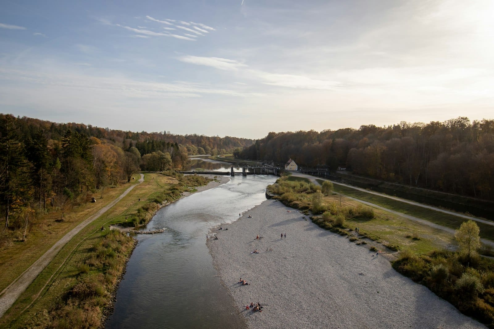
The Isar River runs roughly 292 km from the Karwendel mountains in Tyrol, entering Germany near Mittenwald, through Bavaria, and into the Danube near Deggendorf. Within Munich, it covers just under 14 km, but those 14 km contain the city's most intensively used outdoor space. The Isarauen, the German term for the river's floodplain meadows and gravel banks, are not a park in the managed, manicured sense. There are no entry gates, no ticket booths, no closing times. The area is public urban open space, accessible around the clock year-round, subject only to temporary restrictions during high water or conservation work.
What makes this stretch of river unusual in a European city context is its deliberate rewilding. Between 2000 and 2011, Munich's city administration oversaw a major restoration project that removed the old concrete embankments along significant southern sections and allowed the river to reclaim a more natural, braided channel. The result is a riverscape that feels genuinely wild for a city of 1.6 million people: fast-moving, clear alpine water, gravel and sand bars that shift after floods, and willow-lined islands that appear and disappear with the seasons.
ℹ️ Good to know
The Isar's water originates from alpine snowmelt and springs. Even in July, water temperatures rarely exceed 16–18°C. The current is stronger than it looks, particularly mid-river. Bathing is permitted only in designated sections and always at your own risk, with no lifeguards on duty.
The River Through the Day: What to Expect at Different Hours
Early mornings on a weekday, the Isar banks are practically empty. Joggers and cyclists use the paved paths along the top of the embankments; the gravel banks themselves are quiet enough to hear the water moving over stones. The light before 8 a.m. comes in at a low angle from the east, catching the current in a way that makes the water look almost translucent. This is the best time for photography and for understanding the river's actual width and structure without bodies and towels blocking the view.
By late morning on a warm Saturday in June or July, the dynamic shifts completely. Locals arrive in waves: families with folding chairs, groups of students hauling bags of groceries and portable speakers, office workers who take a long lunch at the water's edge. The Flaucher area, a gravel bar and meadow in the southern section near Thalkirchen, can hold thousands of people on peak summer afternoons. The smell of charcoal from hundreds of barbecues drifts across the banks from around midday onwards, because the Isar is one of the few places in Munich where open-fire barbecuing is officially permitted in designated zones.
Evenings see a gentler crowd: couples walking the footpaths, cyclists heading home, and a residual cluster of swimmers and sunbathers who stay until the light fades. After dark, the paved embankment paths stay in use but the gravel banks empty out. On summer nights when temperatures stay above 20°C, some groups remain well past sunset, though most of the day's energy dissipates by 9 p.m.
⚠️ What to skip
After heavy rain in the Alps, the Isar can rise significantly within hours. If the river looks brown or unusually fast, stay off the gravel banks. The city issues water level warnings via its official channels, and sections of the bank may be closed without much advance notice.
Tickets & tours
Live prices and dates from our booking partner. If you book, we may earn a commission at no extra cost to you.
Guided bike tour through Munich with English Garden and Isar meadows
From 28 €Instant confirmationGuided bike tour through Munich with English Garden and Isar meadows
From 28 €Instant confirmationLuggage Storage in Munich
From 6 €Instant confirmationFree cancellationOne hour city sightseeing bus tour in Munich
From 21 €Instant confirmationFree cancellation
Key Sections Along the River: Where to Go
The Isar passes through multiple Munich neighborhoods, and each stretch has a different character.
Flaucher and Isarauen (Thalkirchen)
The southern stretch near Thalkirchen is where most locals go when they want a full day at the river. The Flaucher area has dedicated barbecue zones, broad gravel beaches, and shallow entry points for swimming. Access is straightforward: take the U3 to Thalkirchen (Tierpark), then walk about 10 minutes north along the river path. The adjacent Isarauen extend south toward Hellabrunn zoo, and the walking path here is flat, wide, and suitable for strollers on the upper embankment level, though the gravel banks below involve uneven footing.
This section is also closest to the Munich Zoo Hellabrunn, which makes it a logical pairing for a family day: zoo in the morning, river in the afternoon.
Reichenbachbrücke to Wittelsbacherbrücke (Central Isar)
The central section of the Isar, running through the Au and Haidhausen neighborhoods, is where the restoration work is most visible. The embankment here has been stepped back from the water, creating wider gravel banks and a more natural river profile. The Corneliusbrücke and Reichenbachbrücke are practical access points, each a short walk from the U-Bahn network. The banks are more mixed-use here: sunbathers, volleyball players on informal sand patches, and a steady flow of cyclists on the upper path.
For anyone exploring the city on two wheels, this stretch connects naturally to a broader cycling route through Munich that runs the length of the river.
Eisbach and the English Garden Connection
At the northern end of the Isar's urban run, near the southern edge of the English Garden, the Eisbach channel splits off from the main river. The Eisbach is famous for a stationary standing wave near the Prinzregentenstrasse bridge where surfers ride year-round, although bathing at the wave itself is officially prohibited. This is a different kind of river experience, urban and performative rather than pastoral, but it is directly connected to the same watershed.
The Eisbach Wave and the broader Englischer Garten are the natural northern terminus of an Isar River day that starts in the south at Flaucher.
Swimming in the Isar: What You Need to Know
Swimming in the Isar within Munich is legal in specific sections and increasingly popular, but it is not a casual, risk-free activity. The water is fast. In the restored southern sections, the current is strong enough mid-river to carry a non-swimmer a significant distance before they can exit. The recommended approach is to enter at a shallow gravel bar, wade in, and let the current carry you downstream at an angle, exiting at the next accessible gravel bank.
Water quality in the Isar has improved substantially over the past two decades following the restoration and ongoing water quality management. The city website indicates the river is used extensively for bathing, but there are no lifeguard stations and no pool-style monitored bathing zones with on-site staff. After heavy rain, runoff can temporarily affect water quality, and the city advises against bathing for a period after significant rainfall events.
Footwear matters more than most visitors expect. The gravel banks are composed of rounded alpine stones, which are comfortable for sitting but awkward to walk across barefoot for any distance. Water shoes or old trainers make entry and exit considerably less painful.
Raft Trips on the Isar
A specific Bavarian tradition connected to the Isar is the wooden raft trip (Floßfahrt), which runs from communities upstream of Munich down through the city and to points south. Organized commercial raft trips typically operate from May 1 to mid-September. These are social events as much as river journeys: groups book a raft, bring food and beer, and float downriver for several hours. Pricing varies by operator and group size and is not set by the city. Booking well in advance is necessary for weekend trips in summer.
💡 Local tip
Raft trips are social and tend to be lively. If you are looking for a quiet nature experience, a raft trip is probably not what you want. If you want to understand how Bavarians celebrate outdoors, it is a concentrated example of exactly that.
Getting There and Practical Logistics
The Isar is reachable from much of Munich without a long journey. For the central riverbanks in the Au and Haidhausen area, the U1 or U2 to Fraunhoferstrasse or U1/U2/U7 to Kolumbusplatz puts you within a 5 to 10 minute walk of the river. For the Flaucher area in the south, the U3 to Thalkirchen (Tierpark) is the standard route, followed by a 10 minute walk north along the river path.
Munich's public transport network covers the area well. The MVV transit system runs U-Bahn, S-Bahn, trams, and buses under a unified ticketing structure. A single trip or day ticket purchased via the MVV app or machines at any U-Bahn station covers all modes.
Cycling to the river is practical and popular. The embankment paths are designated cycling routes and connect to the broader city cycle network. Bike rental is available from multiple providers across central Munich.
Parking near the Flaucher is limited and fills early on warm weekends, sometimes before 10 a.m. If you are driving, allow extra time or park further away and walk. Public transport is the more reliable option.
Accessibility is genuinely limited for wheelchair users and those with restricted mobility. The paved paths along the top of the embankment are manageable, but access to the gravel banks below involves steps or steep gravel paths. There are no ramps or barrier-free entry points to the water-level areas. This is a structural characteristic of the naturalized bank design rather than an oversight.
Seasonal Variation: When to Come
The Isar is used year-round, but the experience changes dramatically by season. Summer, roughly June through August, is peak season, and the Munich summer crowds at the Flaucher can feel overwhelming on a hot Saturday. If you visit in summer, aim for a weekday or arrive before 10 a.m. on weekends.
Spring and early autumn are the most rewarding times for walkers and cyclists. May and September offer mild temperatures, manageable crowds, and the best light for photography. The willows and alders along the banks are particularly striking in April when the new leaves emerge against the grey-green water.
Winter visits are quiet and atmospheric. The gravel banks are nearly empty, frost occasionally coats the stones, and the river runs fast and dark. Cyclists and joggers still use the upper paths on clear days. It is a completely different place, and worth a short walk even in cold weather.
💡 Local tip
The best photography light on the Isar is early morning between May and September, when low sunlight hits the water from the east. The Reichenbachbrücke and Corneliusbrücke offer elevated vantage points above the river for wider compositions.
Insider Tips
- The Flaucher barbecue areas fill up by noon on hot Saturdays. If you want a usable grill spot, arrive before 10 a.m. or come on a weekday. Disposable grills are sold at nearby supermarkets, but bringing your own means you control quality.
- The Isar's gravel banks shift after every major flood, so the exact layout of sand bars, shallow wading areas, and entry points changes from year to year. What you see on older photos may not match current conditions.
- For the quietest stretch of river within central Munich, try the banks between Wittelsbacherbrücke and Ludwigsbrücke on a weekday morning. The restoration work here opened up wide gravel beaches that most visitors walk past without stopping.
- Water shoes or old trainers make a significant difference on the gravel banks. Pack them in your bag even if you are not planning to swim; they also help when wading across the shallows to reach mid-river gravel bars.
- If you want to combine a river walk with a beer garden, the Gaststätte Flaucher near the Flaucher area is a traditional option that has served the local crowd for decades, with outdoor seating under mature trees.
Who Is Isar River & Isarauen For?
- Locals-only experience: The Isar is where Munich residents actually spend warm days, not a tourist attraction in the conventional sense
- Swimmers and waders comfortable with cold, fast water and no lifeguard supervision
- Cyclists looking for a long, mostly flat riverside route through the city
- Families with older children who can handle uneven terrain and strong currents
- Photographers after natural light on moving alpine water within an urban setting
Nearby Attractions
Other things to see while in Haidhausen:
- Maximilianeum
Rising from the eastern bank of the Isar at the end of Maximilianstraße, the Maximilianeum is a 19th-century palatial landmark that serves as both the seat of the Bavarian State Parliament and a foundation for gifted students. Its Neo-Gothic and Historicist façade dominates one of Munich's great axial views, and its story spans royal ambition, wartime destruction, and democratic rebirth.
Planning a trip? Discover personalized activities with the Nomado app.