Hai Van Pass: Vietnam's Most Dramatic Coastal Mountain Road
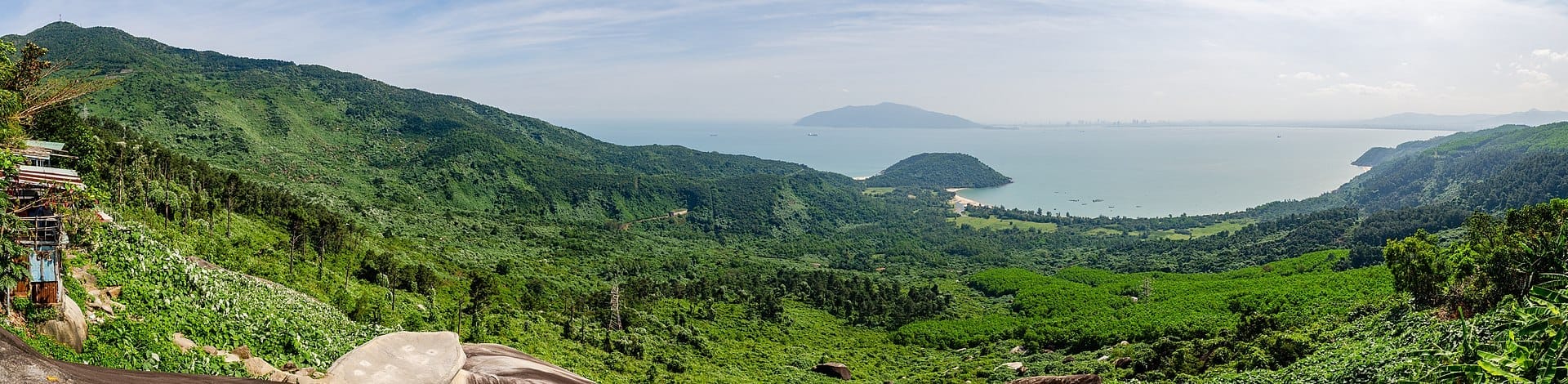
Stretching roughly 20 kilometres and reaching a 496‑metre summit between Da Nang and Hue, Hai Van Pass (Đèo Hải Vân) is one of Vietnam's great scenic drives. The road is free to use, open around the clock, and delivers sweeping views of the East Sea on one side and jungle-clad mountains on the other. Whether you ride a motorbike, hire a car, or join an organised tour, the journey over the pass is the destination.
Quick Facts
- Location
- Between Lien Chieu District, Da Nang and Lang Co, Thua Thien Hue Province. ~20 km north of downtown Da Nang.
- Getting There
- Motorbike or car via National Route 1A. Most long-distance buses use the Hai Van Tunnel rather than the pass road. Most visitors join a tour or rent a motorbike from Da Nang.
- Time Needed
- 1.5–3 hours for the drive and summit stop; a full day if combined with Lang Co Bay or Hue.
- Cost
- Free. No entrance ticket. Hai Van Tunnel toll (from about 40,000 VND for standard cars) applies only if you bypass the pass road.
- Best for
- Motorbike riders, photographers, road-trip travellers, history enthusiasts, and anyone doing Da Nang to Hue overland.
- Official website
- danangfantasticity.com/en/heritage-landscape/hai-van-pass
What Hai Van Pass Actually Is
Hai Van Pass, in Vietnamese Đèo Hải Vân, translates literally as Ocean Cloud Pass, a name that earns its poetry on most mornings when thick mist rolls off the South China Sea and wraps around the ridge. The road is about 20 kilometres long, traversing a spur of the Truong Son mountain range and reaching a summit plateau at roughly 496 metres above sea level, before descending toward Lang Co town and the lagoon flatlands of Thua Thien Hue Province. It is a public road, part of historic National Route 1A, and there is no gate, no ticket booth, and no closing time.
That freedom is part of the appeal, but it also means the experience depends almost entirely on your own planning. You choose your mode of transport, you choose your start time, and you choose how long to linger at the top. The pass rewards those who plan well and punishes those who arrive underprepared in bad weather on an unfamiliar motorbike.
ℹ️ Good to know
The Hai Van Tunnel, which opened in 2005, runs through the mountain base and is the faster route for trucks and buses. Choosing the pass road instead of the tunnel is entirely your decision, and it adds roughly 30–45 minutes to a direct Da Nang to Hue journey.
The Historical Weight of the Summit
The pass has functioned as a dividing line for far longer than Vietnam has existed as a unified country. Between 1306 and 1471, Hai Van Pass marked the frontier between the Cham kingdom in the south and the Vietnamese kingdom of Dai Viet in the north. The cultural split it enforced is still subtly audible in regional accents and visible in temple architecture on either side. After 1471, when Dai Viet absorbed the territory, the pass became a military chokepoint of the first order.
French colonial engineers recognised its strategic value and built fortifications at the summit, some of which still stand. During the American War, both sides used the commanding high ground for observation and defence. The concrete bunkers, gun emplacements, and pillboxes at the top are not reconstructions; they are the real structures, weathered and partially overgrown, and they give the summit an atmosphere that goes well beyond scenic viewpoint.
For travellers doing a broader loop through central Vietnam, the pass fits naturally into a route that includes Hai Van Gate at the summit, and the lagoon landscapes of Lang Co Bay on the Hue side.
Tickets & tours
Live prices and dates from our booking partner. If you book, we may earn a commission at no extra cost to you.
Hai Van Pass and Hue City Full-Day Tour from Hoian-Danang
From 68 €Instant confirmationFree cancellationMarble Mountains, Hai Van pass, and Lang Co beach tour with lunch
From 75 €Instant confirmationFree cancellationHue countryside and Hai Van pass motorbike adventure
From 47 €Instant confirmationFree cancellationFull-day tour from Hue - Hai Van Pass, Lang Co Beach and Truoi Village
From 91 €Instant confirmationFree cancellation
How the Experience Changes by Time of Day
Early morning, between 6 and 8 am, is when the pass delivers its most atmospheric light. The sun rises over the sea to the east and sends long, warm light across the water while the mountain interior stays in cool shadow. Mist frequently clings to the ridgeline at this hour, and the air smells of damp vegetation and salt. Traffic is light, and the only sounds at the summit are wind and distant surf. This is consistently the best window for photography.
By mid-morning, tour groups begin to arrive in earnest, mostly in vans and minibuses that park on the narrow summit area and disgorge passengers for 15-minute photo stops. The summit is not large, and it can feel congested between 9 am and 11 am. Vendors selling coffee, fresh coconuts, and light snacks set up by the old gate structure, and the atmosphere shifts from contemplative to lively.
Midday and afternoon bring harsh, flat light that bleaches the sea views and makes photography less rewarding. Heat on the exposed summit can be significant from April through August. Late afternoon, from around 4 pm onward, sees traffic thin again, and the light becomes interesting once more as the sun drops toward the mountains to the west. Sunset from the summit, facing north toward Lang Co lagoon, can be exceptional on clear days.
⚠️ What to skip
During the rainy season, roughly September through December, the pass road can be shrouded in zero-visibility fog with no warning. Roads become slick with moisture and fallen leaves. Check weather before departing and turn back if visibility drops below 50 metres. Accidents on this road are not uncommon in wet conditions.
Getting There: Your Realistic Options
The most common approach from Da Nang is to rent a semi-automatic or manual motorbike in the city and ride north on National Route 1A through Lien Chieu District. The road is well-signed. The climb begins gradually, then steepens noticeably in the final third before the summit. First-time riders on an unfamiliar bike should treat the hairpin bends with respect; the road surface is generally good but narrow, and heavy vehicles occasionally use the pass instead of the tunnel.
Hiring a private driver or booking a day tour is the more relaxed alternative. Several operators run Da Nang to Hue tours that cross the pass in one direction and use the tunnel in the other, combining the drive with stops at Lang Co Bay and cultural sites in Hue. This option suits travellers who want the view without managing a motorbike on mountain roads.
The pass integrates well into a multi-day central Vietnam itinerary. If you are planning a loop from Da Nang outward, the central Vietnam itinerary guide covers how to sequence the pass with Hue and Hoi An without backtracking.
💡 Local tip
If you are riding from Da Nang, start before 7 am to reach the summit before tour vans and to get the best light. The whole ride from central Da Nang to the summit takes approximately 40–50 minutes without stops.
What You See at the Summit
The summit plateau is anchored by Hai Van Gate, a substantial stone archway built during the Nguyen dynasty that straddles the road. Beyond the gate, a series of fortified positions spread across the ridgeline, some dating to French colonial construction and later modified during wartime. The concrete is cracked and moss-covered, and in places vegetation has broken through the floors. It is rough terrain rather than a manicured site; wear shoes with grip.
Looking south from the summit, the view takes in the full arc of Da Nang Bay. On a clear day, Son Tra Peninsula is clearly visible, its communications tower marking the high point. The city itself spreads along the shore, and My Khe Beach is a pale strip of sand below. To the north, the road descends in visible switchbacks toward Lang Co lagoon, a broad stretch of turquoise water separated from the sea by a narrow sand spit.
Travellers who want to explore the Da Nang side of the mountain range further can combine the pass with time on Son Tra Peninsula, which offers forest trails and coastal lookouts on the opposite headland from the city.
Photography Notes and Practical Details
The south-facing viewpoint, looking over Da Nang Bay, is the classic shot. A wide-angle lens or a phone camera in ultrawide mode handles the full panorama. The light is best in the first two hours after sunrise. Shooting north toward Lang Co works better in the late afternoon, when the lagoon picks up warmer tones.
Drone operators should be aware that the summit area has military heritage structures and proximity to active transport infrastructure. Rules on drone use in Vietnam require Civil Aviation Authority permits for commercial use; even recreational flights can attract attention from locals or passing authorities. Fly cautiously and check current regulations before bringing equipment.
There are no formal amenities at the summit beyond small vendor stalls, which are not always present outside peak hours. Carry water, particularly if visiting in the dry season between April and August when temperatures at the exposed summit can be uncomfortable. Sunscreen and a light windproof layer are worth packing regardless of season, as the ridge catches constant wind off the sea.
For a broader look at the region's scenic high points and how Hai Van fits among them, the Da Nang viewpoints guide gives useful context on what to prioritise if time is limited.
Who Should Skip This
Travellers who are not comfortable on a motorbike and dislike organised tours may find the pass difficult to reach independently and underwhelming once there if they arrive by van for 15 minutes with a crowd. The summit itself is not a polished attraction; it is a weathered historical site on an active mountain road. Visitors expecting a managed experience with clear information panels, café facilities, and safe walking paths will be disappointed.
Anyone visiting during the heart of the rainy season, particularly October and November, should honestly assess weather conditions before committing. The pass in thick fog offers no views and carries real road risk. It is not worth the journey if the cloud is down.
If you are short on time and weighing whether to include the pass in a tight Da Nang itinerary, the 3 days in Da Nang guide helps you prioritise across the city's main draws.
Insider Tips
- Ride or drive from south (Da Nang side) to north (Lang Co side) in the morning to keep the best sea-facing light at your back on the descending bends, then stop at the summit on the way.
- The vendor stalls at the top sometimes brew fresh Vietnamese drip coffee. A slow cup at the summit with that view costs almost nothing and is worth more than any café in the city below.
- Explore the old French and wartime fortifications on the ridgeline above the gate rather than just photographing from the road. The structures extend further than most visitors realise and offer elevated vantage points the roadside crowds miss.
- If you are riding back to Da Nang the same day, consider the timing: the descent toward Da Nang in late afternoon puts the sun directly in your eyes on westward-facing bends. Polarised sunglasses are not optional.
- The pass is in both Da Nang municipality on the south side and Thua Thien Hue Province on the north side. Crossing it means crossing a provincial boundary between the two.
Who Is Hai Van Pass For?
- Motorbike travellers doing the Da Nang to Hue overland route
- Photographers seeking early morning coastal panoramas
- History-minded visitors interested in Vietnam's Cham and colonial-era past
- Road-trippers combining Lang Co Bay with a wider central Vietnam loop
- Travellers who want a memorable half-day that costs nothing and requires no booking
Nearby Attractions
Other things to see while in Hai Van Pass & North Da Nang:
- Hai Van Gate
Perched at nearly 496 metres on the Truong Son range, Hai Van Gate is a restored 19th-century Nguyen Dynasty citadel marking the boundary between Da Nang and Thua Thien Hue Province. Reopened in August 2024 after a major restoration, it offers free admission, sweeping coastal panoramas, and about 200 years of layered military history in a single compact site.
- Lang Co Bay
Lang Co Bay sits at the foot of Hai Van Pass in Thua Thien Hue Province, roughly 30 kilometres north of Da Nang. Its 10-kilometre arc of sand, turquoise shallows, and lagoon backdrop earned it membership in the Club of the World's Most Beautiful Bays in 2009. Entry is free and the beach is open around the clock.
- Nam O Reef & Village
Nam O Reef sits at the edge of a 400-year-old fishing village in Lien Chieu District, about 17 km northwest of Da Nang's center. A free, crowd-light coastal site with a rocky tidal reef, working boats, and one of central Vietnam's last traditional fish sauce communities, it rewards travelers who look beyond the main beach strip.
Planning a trip? Discover personalized activities with the Nomado app.