Hai Van Gate (Hai Van Quan): The Ancient Gateway at the Top of Vietnam's Most Dramatic Pass
Perched at nearly 496 metres on the Truong Son range, Hai Van Gate is a restored 19th-century Nguyen Dynasty citadel marking the boundary between Da Nang and Thua Thien Hue Province. Reopened in August 2024 after a major restoration, it offers free admission, sweeping coastal panoramas, and about 200 years of layered military history in a single compact site.
Quick Facts
- Location
- Summit of Hai Van Pass, border of Lien Chieu District (Da Nang) and Phu Loc District (Thua Thien Hue) — approx. 20–30 km north of central Da Nang
- Getting There
- By car, motorbike, or tour vehicle via National Route 1A north from Da Nang; no direct public bus to the summit. Ride-hailing apps cover the ascent from Da Nang city
- Time Needed
- 45–90 minutes at the gate; budget 2–3 hours total including the scenic drive up and down
- Cost
- Free admission (no ticket required as of 2024; fees may be introduced in future)
- Best for
- History enthusiasts, photographers, road-trippers connecting Da Nang and Hue, early-morning visitors chasing cloud-sea views
- Official website
- danangfantasticity.com/en/heritage-landscape/hai-van-pass
What Hai Van Gate Actually Is
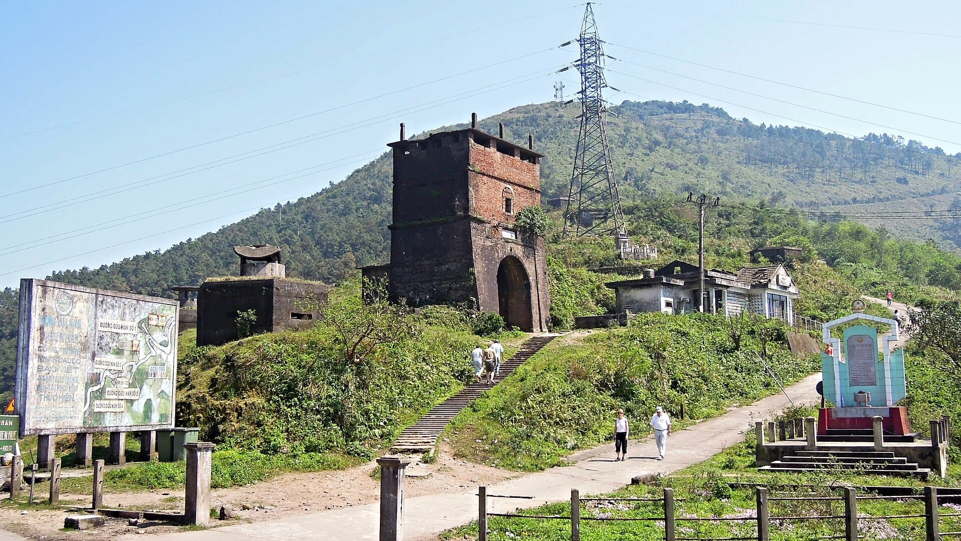
Hai Van Gate, known in Vietnamese as Hai Van Quan, is not simply a viewpoint or a photo stop. It is a fortified citadel gate built in 1826 during the seventh year of Emperor Minh Mang's reign, constructed on the foundation of an earlier Tran Dynasty defensive structure. The Nguyen court built it to control the sole north-south mountain crossing along this stretch of coast, protecting the imperial capital of Hue from the south and commanding views over Da Nang Bay. Roughly 200 years of military use, from medieval Vietnamese lords to French colonial forces to American-era bunkers, have accumulated on this single summit.
The complex sits at approximately 496 metres above sea level on the Bach Ma spur of the Truong Son range, and it physically marks the provincial boundary: the northern archway faces Hue and is inscribed 'Hai Van Quan', while the southern archway facing Da Nang carries the inscription 'Thien ha de nhat hung quan', roughly translated as 'the most magnificent gateway under the heavens'. That southern inscription is not idle boasting. Standing beneath it and looking out over the East Sea, it is difficult to argue otherwise.
Vietnam's Ministry of Culture, Sports and Tourism recognised Hai Van Gate as a national historical site in 2017. The complex then underwent a significant structural restoration beginning December 2021, reopening to visitors on August 1, 2024. What you see today is the result of that careful work: cleaned stone walls, stabilised ramparts, and a gate complex that is finally legible as architecture rather than ruin.
ℹ️ Good to know
Admission is free as of the 2024 reopening. Local authorities have signalled that a ticketing system may be introduced in the future, so check before you go if you are visiting beyond 2025.
The Experience: What You See and Feel When You Arrive
The ascent itself is part of the experience. The road up from the Da Nang side switchbacks through dense tropical forest, and the air changes noticeably as you climb, cooling and growing humid with cloud moisture. On clear mornings, you emerge above a soft white layer of cloud that fills the valley below like a lake. On overcast days, you drive directly into the mist, and the gate appears gradually out of the fog, its dark stone walls dripping with condensation. Both versions are worth seeing, for different reasons.
At the summit, the gate structure is compact. The main archway is broad enough to drive a vehicle through, flanked by thick stone walls that extend along the ridge. French-era and American-era concrete fortifications are still visible on the hillside, not restored but not hidden either. They sit alongside the Nguyen stonework as an honest record of the site's continued military use through the 20th century. The texture of the site is rough limestone and laterite, worn smooth in some places by centuries of passing foot traffic.
The views from the rampart walls are the main draw for most visitors. To the south, the entire sweep of Da Nang Bay opens below you, with My Khe beach visible as a pale arc and the Son Tra Peninsula rising beyond it. To the north, Lang Co Bay glitters in the middle distance, a long sand spit separating a lagoon from the open sea. On clear days, both views are available simultaneously from the same spot.
Riders who know Vietnam's motorbike culture will recognise this as the pass made famous internationally by the Top Gear Vietnam special. That context brings a certain category of visitor, but the historical weight of the site long predates any television programme. If you want the full geographical picture of where Hai Van Pass sits in central Vietnam, the Da Nang mountains guide covers the broader range of highland sites in the region.
Tickets & tours
Live prices and dates from our booking partner. If you book, we may earn a commission at no extra cost to you.
Hai Van Pass and Hue City Full-Day Tour from Hoian-Danang
From 68 €Instant confirmationFree cancellationPrivate transfer from Da Nang to Hue with stop at Hai Van and Lang Co
From 111 €Instant confirmationFree cancellationPrivate Return Transfer from Da Nang to Hai Van and Lang Co
From 85 €Instant confirmationFree cancellationPrivate transfer between Da Nang's city centre and Hai Van or Lang Co
From 95 €Instant confirmationFree cancellation
Time of Day and Weather: When to Go and What to Expect
Early morning, roughly 6:00 to 8:00, consistently produces the best conditions. Cloud inversions are most likely in the hour after dawn, when the valleys on both sides fill with mist while the summit stays clear. The light at this hour is cool and directional, useful for photography of the stone walls and archways. By mid-morning the clouds typically burn off, the tour vehicles begin arriving in numbers, and the summit can feel crowded on the narrow ramparts.
Midday is the least rewarding time to visit. The sun is nearly overhead, shadows are flat, heat radiates from the stone, and the viewing area is at its most crowded. If your schedule only allows a midday stop, the gate is still worth a look, but manage expectations for the photographs.
Late afternoon, especially from around 4:00 onward, brings warm low-angle light and a gradual thinning of the tour crowd. The Da Nang Bay view to the south picks up a gold cast that makes it one of the better photography windows of the day. However, be aware of descent timing: the road down from the pass after dark on a motorbike is not advisable given the steep curves and limited lighting.
⚠️ What to skip
Da Nang's wet season runs from roughly September through March. During this period, the pass summit is frequently enveloped in cloud or rain for most of the day. Views may be completely obscured. The site remains accessible and historically interesting, but if clear panoramas are your priority, plan your visit between April and August.
Historical and Cultural Context
The Hai Van Pass, 'Pass of Clouds and Ocean' in literal translation, has divided Vietnam's north and south since before any modern political boundary existed. The Truong Son range here pushes all the way to the sea, leaving only this narrow coastal gap and the mountain crossing above it. For medieval Vietnamese kingdoms, and later for the Nguyen lords and emperors, whoever controlled Hai Van controlled the movement of armies, merchants, and tribute between the north and south of the country.
The 1826 construction under Minh Mang formalised what had been a defended crossing for centuries. The Nguyen Dynasty built in the Chinese garrison-fort style, with thick walls, firing positions, and a formal gateway that served both military and ceremonial functions. Envoys from the imperial court in Hue passed through this gate heading south. Tax collectors, soldiers, and traders all passed through in the other direction. The inscription 'Thien ha de nhat hung quan', likely added after the initial construction, reflects the imperial confidence of the early Nguyen period.
The French occupied the structure in the colonial period, adding their own fortifications to what was already a militarily obvious position. During the American War, the pass remained strategically significant, and concrete bunkers were added to the ridge. These are now part of the site's layered record, neither demolished nor especially interpreted for visitors. A basic understanding of Vietnamese military history enriches a visit considerably, as the site does relatively little hand-holding through signage.
The gate sits directly on the road that connects Da Nang and Hue, making it a natural stop on a central Vietnam itinerary. Most visitors combine it with the drive through Lang Co Bay on the northern descent, which offers one of the more photogenic coastal stretches in the region.
Practical Walkthrough: Getting There and Getting Around the Site
From central Da Nang, the drive north on National Route 1A takes approximately 30 to 45 minutes depending on traffic, before the road begins its ascent of the pass. The climb itself takes another 15 to 20 minutes by car or motorbike. The road is sealed and in generally good condition, but the curves are tight and the drop on the seaward side is steep. Motorbike riders should be comfortable with mountain roads before attempting this independently.
At the summit, parking is available on a small area adjacent to the gate. The site has no formal entrance queue or ticketing booth. Vendors sell drinks and light snacks from stalls near the gate. There are basic toilet facilities at the summit, though quality is variable.
The gate complex itself takes 30 to 45 minutes to explore properly, longer if you spend time on the ramparts. Wear closed shoes with grip. The stone surfaces are uneven, and the outer walls involve steps and inclines without handrails in places. The site is not wheelchair accessible in any meaningful sense, and visitors with significant mobility limitations should be aware that the viewing areas on the walls are reached by steep stone steps.
If you are not self-driving, hiring a car with a driver for the day is the most practical option. Several operators in Da Nang offer a Da Nang to Hue day trip that includes the gate, Lang Co Bay, and other stops. For context on the full pass route, the Hai Van Pass attraction page covers the full road experience rather than the gate structure specifically.
💡 Local tip
Bring a light jacket even in the dry season. The summit sits at nearly 500 metres, and the temperature is noticeably cooler than the coast, particularly in early morning and after rain. Cloud moisture also means surfaces stay damp, so a jacket doubles as wind protection on the exposed ramparts.
Photography Notes
The two archways frame compositions effectively. The southern gate inscription, with the Da Nang Bay visible through the arch on clear days, is the most reproduced shot from this site. The northern archway looking toward Hue gives a narrower mountain-road framing with forest on both sides. Both work best in morning or late afternoon light when the stonework has shadow and texture rather than washing out in midday glare.
For landscape work, a wide-angle lens captures the full sweep of both bays from the rampart walls. A longer focal length compresses the distance between the sea and the ridge and works well for isolating the bunker silhouettes against sky. Drone operators should be aware that airspace regulations near Vietnamese administrative boundaries and military sites are strictly enforced; do not fly a drone at Hai Van Gate without verifying current permits.
Who This Site Suits and Who Might Be Disappointed
Hai Van Gate rewards visitors who are interested in history, architecture, or landscape photography and are willing to make the drive. The site does relatively little interpretive work. Signage is minimal, and there is no audio guide or visitor centre. If you need a site to tell you what you are looking at, you may leave feeling vaguely underwhelmed. Reading about the Nguyen Dynasty and the history of the pass before you arrive makes an enormous difference to how much the place communicates.
Families travelling with young children will find the site manageable but not especially child-focused. There is open space, some stone walls to scramble on, and good views, but no activities, exhibits, or interpretation designed for younger visitors. For a more structured family outing in the Da Nang region, see the Da Nang with kids guide for alternatives that offer more to occupy younger travellers.
Visitors making a fast transit between Da Nang and Hue who want a single stop that combines history, views, and a genuine sense of place will find this site delivers precisely that. It is not overhyped in the way that some coastal viewpoints in the region are. The historical substance is real, the views are exceptional on clear days, and the recent restoration has made the architecture legible without sanitising it.
Insider Tips
- Arrive before 7:30 in the morning to catch the cloud inversion over Da Nang Bay. This phenomenon, where cloud fills the valley while the summit stays clear, disappears within an hour of sunrise most days during dry season.
- The southern inscription 'Thien ha de nhat hung quan' is on the Da Nang-facing side of the gate. Many visitors photograph only the northern Hue-facing side and miss the more historically significant southern inscription entirely. Walk through the arch and look back.
- The French and American concrete bunkers on the hillside above the gate are not fenced off. Walking up to them adds 10 to 15 minutes and gives an elevated angle looking back down at the Nguyen archways, a perspective most visitors never see.
- If you are travelling between Da Nang and Hue by car, ask your driver to stop at the small pull-out about 2 kilometres below the summit on the Da Nang side. The view of the coastline from this lower angle, with the road snaking up the cliff face, is a different and equally striking composition.
- Admission is currently free but this may change. Take a small amount of Vietnamese dong for drinks and snacks from the summit vendors, who accept cash only.
Who Is Hai Van Gate For?
- History and architecture enthusiasts wanting to engage with authentic Nguyen Dynasty military heritage
- Photographers targeting early-morning cloud-inversion shots over Da Nang Bay and Lang Co
- Road-trippers on the Da Nang to Hue route seeking a stop with genuine historical weight rather than a commercial attraction
- Travellers who prefer uncrowded, open-air sites with no entrance fee and no structured queuing
- Motorbike riders completing what many consider Vietnam's most scenic coastal mountain pass
Nearby Attractions
Other things to see while in Hai Van Pass & North Da Nang:
- Hai Van Pass
Stretching roughly 20 kilometres and reaching a 496‑metre summit between Da Nang and Hue, Hai Van Pass (Đèo Hải Vân) is one of Vietnam's great scenic drives. The road is free to use, open around the clock, and delivers sweeping views of the East Sea on one side and jungle-clad mountains on the other. Whether you ride a motorbike, hire a car, or join an organised tour, the journey over the pass is the destination.
- Lang Co Bay
Lang Co Bay sits at the foot of Hai Van Pass in Thua Thien Hue Province, roughly 30 kilometres north of Da Nang. Its 10-kilometre arc of sand, turquoise shallows, and lagoon backdrop earned it membership in the Club of the World's Most Beautiful Bays in 2009. Entry is free and the beach is open around the clock.
- Nam O Reef & Village
Nam O Reef sits at the edge of a 400-year-old fishing village in Lien Chieu District, about 17 km northwest of Da Nang's center. A free, crowd-light coastal site with a rocky tidal reef, working boats, and one of central Vietnam's last traditional fish sauce communities, it rewards travelers who look beyond the main beach strip.
Planning a trip? Discover personalized activities with the Nomado app.