Calico Hills: Red Rock Canyon's Most Striking Sandstone Landscape
Calico Hills is a stretch of dramatically banded red and cream sandstone formations along the Scenic Loop Drive in Red Rock Canyon National Conservation Area. Accessible by car, foot, or bike, it offers some of the most photogenic desert scenery within striking distance of Las Vegas, with trails ranging from easy wanders to rocky scrambles.
Quick Facts
- Location
- Red Rock Canyon National Conservation Area, Nevada — approx. 17 miles west of the Las Vegas Strip
- Getting There
- No public transit to the canyon; drive west on Charleston Blvd (NV-159) or join an organized tour. Parking available at Calico I and Calico II pullouts along the Scenic Loop Drive.
- Time Needed
- 2 to 4 hours for a full Calico Hills visit; combine with the full Scenic Loop for a half-day
- Cost
- US$20 per private vehicle; US$10 motorcycle; US$10 bicycle; pedestrian access is covered under vehicle and motorcycle entry. A $2 reservation fee applies Oct 1 – May 31. America the Beautiful pass accepted.
- Best for
- Hikers, photographers, geology enthusiasts, and families looking for accessible desert scenery near Las Vegas
What Calico Hills Actually Is
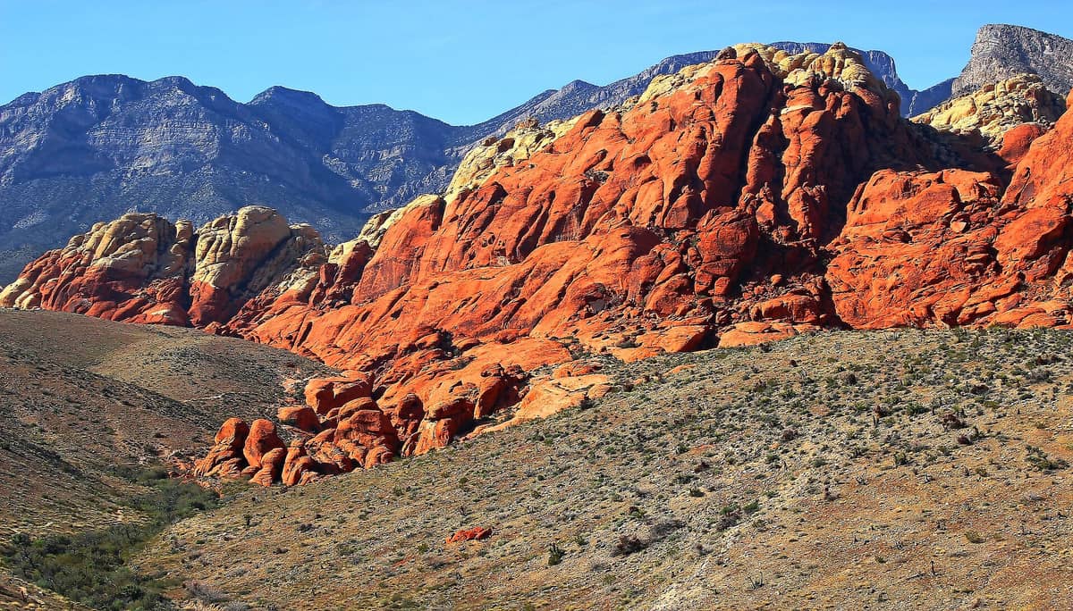
Calico Hills is not a single peak or a formal trail with a tidy trailhead sign. It is a broad sweep of eroded Aztec sandstone formations that line the eastern edge of the Red Rock Canyon National Conservation Area, forming the first major geological feature most visitors encounter after entering the Scenic Loop Drive. The rocks themselves are the attraction: layered bands of deep rust-red, salmon, and off-white stone, deposited as ancient sand dunes and compressed over roughly 180 million years into the formations you see today. Iron oxide gives the redder sections their color; calcium carbonate cements the paler cream zones. Up close, the surface has a rough, granular texture, and the stone holds warmth well into the evening after a sunny day.
The official BLM recreation description places Calico Hills along the corridor running from Calico Basin to Sandstone Quarry. Two main roadside pullouts, Calico I and Calico II, give direct access to the base of the formations. From these points, informal use-paths fan out across the rock, and the more established Calico Hills Trail links the area into a longer route. There are no interpretive panels at every turn; this is a place where the landscape speaks plainly, without a lot of curatorial assistance.
ℹ️ Good to know
The Scenic Loop Drive operates on seasonal hours: 6:00 a.m. to 5:00 p.m. November through February, 6:00 a.m. to 7:00 p.m. in March and October, and 6:00 a.m. to 8:00 p.m. April through September. The Visitor Center is open daily 8:00 a.m. to 4:30 p.m. Arrive well before closing, especially in winter.
How the Light Changes Everything
The color intensity of Calico Hills shifts dramatically depending on when you arrive. In the hour after the canyon opens in the morning, the low-angle sun hits the eastern faces of the formations directly, turning the iron-rich stone a deep copper-red and throwing long shadows that exaggerate every fold and crevice. This is the most photogenic window of the day, and experienced photographers target it specifically. The air at this hour is still cool, often in the 50s Fahrenheit in spring and autumn, and the canyon is quiet enough that you can hear birds calling from the wash below.
By midday, especially in summer, the light flattens and the temperature at the base of the rocks can climb well above 100 degrees Fahrenheit. The sandstone radiates stored heat, and shade disappears. This is when the experience becomes genuinely uncomfortable and, in the hottest months of June through August, potentially dangerous for anyone without adequate water. Afternoon thunderstorms are possible in late summer, which can make the sandstone slick and cause flash flooding in the washes. Check conditions before heading out.
The last 90 minutes before the loop closes in the afternoon offer another quality light window, though it is less dramatic than early morning. The formations take on a warmer glow, and the crowd has usually thinned. Autumn and spring afternoons at Calico Hills are genuinely pleasant: temperatures in the 60s to low 70s, clear skies, and occasional wildflower color at the base of the rock.
⚠️ What to skip
Summer visits (June through August) require serious preparation. Carry at least two liters of water per person, wear sun protection, and plan to be off exposed rock by 10:00 a.m. Heat-related illness is a documented risk at Red Rock Canyon during peak summer months.
Tickets & tours
Hand-picked options from our booking partner. Prices are indicative; availability and final rates are confirmed when you complete your booking.
Self-guided e-bike tour of Red Rock Canyon
From 86 €Instant confirmationFree cancellationRed Rock Canyon classic tour
From 97 €Instant confirmationFree cancellationRed Rock Canyon with Rocky Gap adventure tour
From 123 €Instant confirmationFree cancellationSelf-guided e-bike tour of Red Rock Canyon with pick-up
From 108 €Instant confirmationFree cancellation
Trails and How to Navigate the Area
The Calico Hills area offers several ways to engage with the landscape, depending on your fitness level and how much time you have. The most straightforward approach is to park at the Calico I pullout and walk the informal paths that lead directly to the base of the formations. This requires no navigation skills and takes around 20 to 30 minutes as a casual stroll. The ground is sandy in places, firm sandstone in others, and the transition between the two keeps you attentive.
For a longer route, the Calico Hills Trail runs from Calico Basin through the heart of the formations and connects toward Sandstone Quarry. This trail covers moderate terrain and includes some rock scrambling, particularly if you leave the main path to explore the higher ledges. Trekking poles are useful on the descent sections. Trail-running shoes or proper hiking boots with ankle support are recommended; standard sneakers work on the flatter sections but lose traction quickly on steep sandstone.
The area integrates naturally with the full Red Rock Canyon Scenic Drive, a one-way 13-mile loop that passes Calico Hills as its first major stop before continuing to Sandstone Quarry, Willow Spring, and Pine Creek Canyon. Doing both in a single half-day is the standard approach for visitors with a rental car.
💡 Local tip
Calico I has designated accessible parking spaces. However, the BLM notes that no designated trails along the Scenic Loop Drive are considered accessible to strollers or standard mobility devices. The terrain beyond the parking area involves uneven rock and sand.
Getting There from Las Vegas
Calico Hills sits approximately 17 miles west of the Las Vegas Strip, a drive of around 30 minutes under normal traffic conditions. The standard route follows West Charleston Boulevard (Nevada State Route 159) directly to the Red Rock Canyon NCA entrance. The road is straightforward and well-signed. Most visitors drive their own rental car or a personal vehicle; this is by far the easiest approach.
There is no public bus service directly to Red Rock Canyon. The regional transit network does not extend to the canyon entrance, so visitors without a car need to book through one of the many guided tour operators in Las Vegas, rent a bicycle for the loop (though the 13-mile one-way drive requires serious fitness), or arrange a rideshare. Note that rideshare availability for the return journey from remote canyon pullouts is unreliable; drivers are scarce in the area. If you take an Uber or Lyft out, plan your pickup from the Visitor Center, not mid-loop.
If you are building a broader itinerary around Red Rock Canyon, the hiking near Las Vegas guide covers trailhead logistics for the wider area, including ice box canyon and Pine Creek Canyon, both of which are accessible from the same scenic loop.
Photography Notes
The Calico Hills formation is one of the most photogenic geological features within easy reach of Las Vegas, but producing images that stand out requires some deliberate choices. The obvious shot, from the parking area looking directly at the rock face, is fine but identical to what tens of thousands of visitors capture every year. Moving laterally along the base of the formations, or finding a low angle that emphasizes the layering in the stone, produces more interesting results. The contrast between the cream sandstone and the dark desert varnish streaks running down the cliff faces is particularly striking in early morning light.
Wide-angle lenses work well for capturing the scale of the formations against the sky. A polarizing filter significantly improves color saturation and cuts glare off the sandstone. In winter, snow occasionally dusts the upper reaches of the Spring Mountains visible in the background, adding visual contrast. Calico Hills faces roughly east, which means afternoon shots place the rock in shade while the sky remains bright; this is a challenging exposure scenario without graduated filters or HDR techniques.
💡 Local tip
For the best photography conditions, arrive within the first hour after the Scenic Loop opens. In summer that means being parked at Calico I by 6:30 a.m. In spring and autumn, the 7:00 to 9:00 a.m. window delivers warm light without requiring a pre-dawn start.
What to Realistically Expect
Calico Hills delivers on its core promise: the sandstone formations are genuinely striking, the sense of scale is real, and the landscape feels meaningfully different from the desert floor around Las Vegas. That said, visitors expecting developed facilities should calibrate expectations. There are no food vendors, no shade structures, and no interpretive facilities at the Calico pullouts themselves. The Visitor Center, located near the entrance, is the place to pick up maps, use restrooms, and ask rangers questions before heading deeper into the loop.
The area draws a broad mix of visitors: trail runners who use the early morning hours before the car traffic builds, families with young children who stick to the sandy flats at the base of the rock, and serious climbers who treat the formations as technical bouldering terrain. Rock climbing is permitted in some areas of Red Rock Canyon NCA; check current regulations with the BLM before attempting any roped climbing. If you want more developed hiking infrastructure and clearly marked trails, the Pine Creek Canyon Trail further along the loop offers a more structured experience.
Visitors who might not get much from Calico Hills include those who find desert landscapes repetitive, anyone expecting a traditional park experience with interpretive programming and paved walkways, and travelers who are visiting Las Vegas primarily for the Strip and want a brief outdoor detour without real engagement. If you fall into that last category, the short walk to the Calico I pullout still delivers a striking view for minimal effort, and you can spend 30 minutes and call it done without feeling shortchanged.
Calico Hills pairs well with other nearby attractions in the Red Rock Canyon area. Seven Magic Mountains, the colorful boulder art installation, is located on the highway south of the city rather than at Red Rock itself, but the Seven Magic Mountains makes a logical add-on for a day of Nevada desert landscapes. For those considering a longer day, Valley of Fire State Park offers similar sandstone scenery on a larger scale, about an hour northeast of Las Vegas.
Insider Tips
- The Calico I pullout fills up quickly on weekends between October and May. If you arrive after 9:00 a.m. on a Saturday, expect to wait for a parking spot or continue to Calico II, which has more capacity and slightly different angles on the formations.
- A timed reservation is required for private vehicles entering the Scenic Loop from October 1 through May 31 for entry between 8:00 a.m. and 5:00 p.m. Book through recreation.gov well in advance during peak spring season — weekends in March and April sell out fast. A $2 reservation fee applies in addition to the vehicle entry fee.
- The sandstone at Calico Hills is fragile in ways that are not immediately obvious. Biological soil crust, the dark, bumpy surface crust visible between rocks, takes decades to form and is destroyed by a single footstep. Stay on established rock or sandy wash surfaces rather than cutting across the crust.
- If you want to add a picnic, the Calico Basin area just outside the NCA entrance has a small, informal picnic area with shade and is free to access. It makes a good lunch stop before or after the Scenic Loop.
- Wildlife is more active at Calico Hills in the early morning. Desert tortoises are occasionally seen near the base of the formations in spring and early summer. Bighorn sheep frequent the higher reaches of the canyon and are sometimes visible from the Calico pullouts with binoculars.
Who Is Calico Hills For?
- Photographers targeting Mojave Desert landscapes within a day trip of Las Vegas
- Hikers looking for a moderate half-day desert trail without driving hours from the Strip
- Geology enthusiasts interested in Jurassic-era sandstone formations and visible mineral banding
- Families with older children comfortable on uneven terrain and rock surfaces
- Visitors wanting an outdoor reset from the Strip with straightforward logistics and no permit complexity
Nearby Attractions
Other things to see while in Red Rock Canyon Area:
- Ice Box Canyon Trail
Ice Box Canyon Trail delivers one of the most rewarding short hikes in Red Rock Canyon National Conservation Area, combining a well-marked desert path with boulder scrambling, cool canyon shade, and a seasonal waterfall. At roughly 2.5 to 3 miles round trip, it delivers a lot of scenery for a short hike for scenery and adventure.
- Pine Creek Canyon Trail
Pine Creek Canyon Trail cuts into one of Red Rock Canyon's most visually dramatic corridors, delivering towering Aztec sandstone walls, a seasonal creek lined with cottonwoods, and remnants of a historic homestead, all within a manageable 2-mile round trip. Located inside the Red Rock Canyon National Conservation Area about 17 miles west of the Las Vegas Strip, it rewards hikers of most fitness levels with outsized scenery relative to the effort involved.
- Red Rock Canyon Scenic Drive
The Red Rock Canyon Scenic Drive is a 13-mile one-way road through one of the Mojave Desert's most geologically dramatic landscapes, located about 17 miles west of Las Vegas. From cream-colored limestone cliffs to rust-red sandstone formations, it delivers a complete change of scene from the Strip — and requires almost no hiking to appreciate.