Akerselva River Walk: Oslo's Industrial River Turned Urban Green Trail
The Akerselva River Walk traces an 8-kilometre corridor from Maridalsvannet lake through Grünerløkka and into central Oslo, weaving past waterfalls, converted mill buildings, and riverside parks. It costs nothing, runs open all year, and gives a more honest picture of Oslo's character than almost any paid attraction in the city.
Quick Facts
- Location
- Akerselva river corridor, Grünerløkka, Oslo, Norway
- Getting There
- Nydalen T-bane (metro); tram 12 and bus 54 serve multiple points along the route; Grønland T-bane near the southern end
- Time Needed
- 2–4 hours for the full 8 km walk; 1 hour for the Grünerløkka stretch alone
- Cost
- Free. The trail is a public path with no entrance fee
- Best for
- History lovers, photographers, joggers, families, anyone wanting to understand Oslo beyond the tourist centre
- Official website
- www.visitoslo.com/en/articles/akerselva-river
What the Akerselva River Walk Actually Is
The Akerselva River Walk follows the Akerselva, Oslo's primary urban river, along a marked public path that stretches approximately 8 kilometres from Maridalsvannet, Oslo's largest lake and main drinking water reservoir, down through inner-city neighbourhoods and into the Vaterland area near Brugata in central Oslo. Over its full length the river drops around 150 metres in elevation, which means waterfalls, rapids, and the steady white-noise presence of moving water throughout the walk.
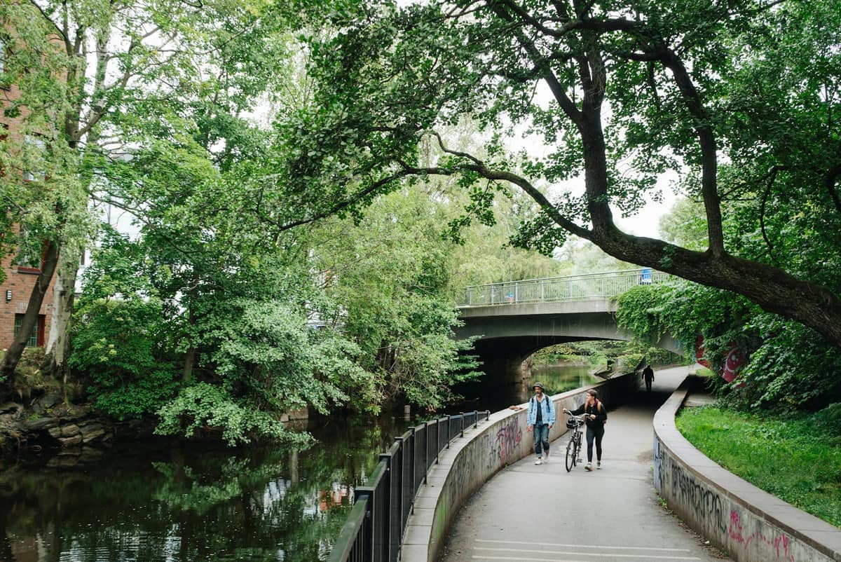
This is not a manicured park path. Parts of it are properly wild, with tree roots breaking through gravel and uneven stone steps descending to the water's edge. Other sections pass directly through the backyards, so to speak, of Grünerløkka's café culture, where you can step off the trail and get a coffee within two minutes. That contrast, between raw nature and dense urban life, is the walk's defining quality.
Much of the corridor is recognised by Oslo municipality as a cultural heritage area with many protected sites along the riverbanks. For visitors trying to understand how Oslo works as a city, not just as a collection of monuments, walking Akerselva is more revealing than most museum visits. It also fits naturally into a three-day Oslo itinerary as a half-day route that connects several neighbourhoods.
💡 Local tip
The most accessible and visually rewarding section runs between Nydalen and Grünerløkka (roughly the middle third of the full route). If you only have an hour, start at Nydalen T-bane station, follow the river south, and finish at Grünerløkka's Birkelunden park.
The History Behind the Riverbanks
Akerselva powered Oslo's industrial revolution. From the early 19th century through to the mid-20th century, more than 40 factories, mills, and workshops lined its banks, using the river's energy to drive machinery. Textile mills, sawmills, paper factories, and chemical plants occupied both sides of the water. At its industrial peak, the river corridor was one of the most densely industrialised urban zones in Scandinavia.
By the 1970s and 1980s, most of the factories had closed. What followed was a decades-long transformation, partly organic, partly planned, that converted mill buildings into apartments, galleries, and offices while preserving the riverbanks as public green space. The brick chimney stacks and stone mill facades that remain are not decorative: they are the original structures, repurposed. Walking the river, you read layers of the same city across two centuries.
Grünerløkka itself grew up as a working-class district to house the factory workers who laboured along the river. The neighbourhood's dense grid of late-19th-century apartment blocks reflects that history directly. Today it's Oslo's most characterful inner-city neighbourhood, and the river is the axis it pivots around. For more on the area's texture, the Grünerløkka neighbourhood guide covers it in detail.
Tickets & tours
Live prices and dates from our booking partner. If you book, we may earn a commission at no extra cost to you.
Oslo private city walk
From 23 €Instant confirmationFree cancellationHighlights of Oslo walking tour
From 30 €Instant confirmationFree cancellationFeel like a royal in this private walking tour
From 49 €Instant confirmationFree cancellationDiscover the highlights of Oslo in a private walking tour
From 71 €Instant confirmationFree cancellation
Walking the Route: What You Pass Section by Section
The upper section, from Maridalsvannet down to Nydalen, is the quietest stretch. The forest thickens here, the path narrows, and the river runs fast and relatively wild. You pass several small waterfalls in this section, and in summer the vegetation closes in to form a genuine green tunnel. This part suits walkers who want the nature experience without much else. It is also the section least served by public transport, so most visitors access it specifically rather than stumbling into it.
The middle section, Nydalen to Grünerløkka, is where industrial heritage is most concentrated. You pass the heavy stone walls of former factory complexes, some still bearing the names of the companies that occupied them. The Akersfossen waterfall sits within this stretch, a proper cascade that drops several metres in the middle of the city, usually audible before it becomes visible. The BI Norwegian Business School campus at Nydalen occupies several converted factory buildings here, which gives the upper entry point an interesting mixed atmosphere of student life and historical fabric.
The lower section, through Grünerløkka and down toward Vaterland, is the most urban. The riverbanks here are landscaped and regularly crowded on warm days. Benches face the water, grills are set out in summer, and the mix of people reflects the neighbourhood, which is to say: varied, informal, and generally relaxed. The path ends near Brugata and Grønland, which puts you within walking distance of Oslo Central Station.
ℹ️ Good to know
Guided walking tours of Akerselva run seasonally through Oslo Guidebureau (the 'Historic River Walk'). These carry a ticket cost and have fixed departure times. The information here covers the self-guided public trail, which is always free and always open.
How the Walk Changes by Time of Day and Season
Early morning, before 8am, the lower sections near Grünerløkka have a genuinely peaceful quality. Dog walkers move along the banks, the cafés are just opening, and the river sound is clear rather than competing with conversation. The light in summer mornings hits the water at a low angle that photographers tend to seek out.
Midday on a summer weekend brings a different experience. The grassy banks fill with people eating lunch, sunbathing on flat rocks, or watching the current. It becomes social infrastructure as much as a nature trail. This is not a quiet escape in summer afternoons; it is Oslo using its river as a living room. If you want solitude, come before 9am or head to the upper section.
Autumn is arguably the walk's best season. September and October bring leaf colour that intensifies around the older trees along the banks. The crowds thin considerably, the air has a sharpness that makes the waterfalls more dramatic, and the brick factory walls take on a richer tone in lower light. Rain, which is more frequent in October, makes the rapids louder and gives the moss-covered stones a deep green that photographs well but requires waterproof footwear.
Winter transforms the walk into something quieter and colder. Ice forms at the edges of the river in January and February, and some sections can be slippery. Snowfall on the stone mills creates genuinely striking scenes, and the absence of foliage opens views through the trees that summer hides. Layer appropriately. For broader seasonal context, the Oslo in winter guide covers what to expect city-wide.
Getting There and Practical Logistics
For the full north-to-south walk, the most practical starting point is Nydalen T-bane station on the Oslo Metro. From there, it is a short walk down to the river, and you follow it south. The full walk to Vaterland/Brugata takes roughly two to three hours at a relaxed pace, including stops. For the upper section from Maridalsvannet, bus 54 from Jernbanetorget toward Kjelsås, alighting at a stop near Akerselva by Brekke, brings you close to the northern end of the marked trail.
The southern end deposits you near Grønland T-bane and Oslo Central Station, so there are no logistical headaches getting back into the city centre. The route is essentially linear, which means you can stop at any point and catch public transport without backtracking.
Footwear matters more than most city walks. The path has long paved stretches, but also compacted gravel, stone steps, and occasional muddy sections. Trail shoes or sturdy walking shoes are more comfortable than trainers on the rougher northern sections. The middle and lower sections are fine in ordinary shoes in dry weather.
⚠️ What to skip
Wheelchair accessibility is limited and varies by section. The lower Grünerløkka stretch is the most accessible. The upper sections toward Maridalsvannet have significant uneven terrain and steps. Check specific segments before visiting if mobility is a concern.
Photography Along the Walk
Akerselva is one of the more photogenic urban walks in Scandinavia, though it rewards patience more than quick stops. The Akersfossen waterfall in the middle section works best in overcast light, which reduces harsh shadows on the white water. The old mill facades photograph well in the golden hours of early morning or late afternoon. In the lower section, the combination of graffiti-covered brick walls and flowing water creates a textural contrast that urban photographers consistently seek out.
For a curated sense of Oslo's best viewpoints and visual stops, including several that connect naturally to the river walk, the Oslo viewpoints guide is worth consulting before you plan your route.
Who Gets the Most Out of This Walk (and Who Might Not)
Visitors who come to Oslo for urban history, architecture, or simply to understand a city on foot will find Akerselva disproportionately rewarding for a free walk. Runners use the path regularly; it is one of Oslo's most popular jogging routes. Families with children manage the middle and lower sections without difficulty. Photographers, particularly those drawn to industrial textures and water, will want to spend significant time here.
Travellers who prefer compact, clearly-narrated experiences, where someone tells them what they are looking at, may find the self-guided format underwhelming without background reading. The river does not explain itself. For that kind of structured experience, the paid guided tours are a better fit. And visitors primarily interested in Oslo's major museums, such as the Munch Museum or the National Museum, may want to fold a short river section into a half-day rather than dedicating a full walk to it.
Anyone expecting a pristine wilderness experience should adjust expectations. This is a city river with city sounds, and sections of the lower trail pass through areas that are functional rather than scenic. The value of the walk is cumulative and contextual, not concentrated in a single viewpoint.
Insider Tips
- The Akersfossen waterfall is most dramatic after heavy rain or during spring snowmelt (typically March to May), when the volume of water increases significantly. Visit then if you want the full cascade effect.
- Several of the old mill buildings along the middle section have been converted into creative studios and galleries. Keep an eye out for open doors, particularly on weekends, when some occupants run informal open-house events.
- The grassy banks and small parks along the lower Grünerløkka section, particularly around Kuba, have built-in barbecue grills available for public use in summer. Locals bring charcoal and food; it is an entirely normal thing to do and a good way to stop mid-walk.
- If you are walking south, resist finishing at Vaterland and instead continue a few minutes east to Grønland for some of Oslo's best and most affordable food, including several excellent kebab and Middle Eastern places that are far removed from the tourist-centre price bracket.
- The walk pairs naturally with Mathallen Oslo, the covered food market that sits just off the river near Vulkan. It is a good lunch stop mid-route without requiring a significant detour from the path.
Who Is Akerselva River Walk For?
- Urban history enthusiasts who want to understand Oslo's industrial past through physical remains rather than museum displays
- Runners and joggers looking for a scenic, traffic-free route through the city
- Photographers interested in industrial textures, moving water, and the intersection of nature and city
- Budget travellers: the walk is entirely free and passes cafés and food spots at multiple price points
- Families with children who want outdoor time without long drives or admission fees
Nearby Attractions
Other things to see while in Grünerløkka:
- Mathallen Oslo
Mathallen Oslo brings together dozens of specialty food vendors, restaurants, and cafés under one roof in the revitalized Vulkan district along the Akerselva river. Free to enter, it works equally well as a quick lunch stop or an unhurried afternoon of eating and browsing. This guide covers what to find inside, the best times to visit, and how to get there.
Planning a trip? Discover personalized activities with the Nomado app.