Point Reyes National Seashore: Wild Coast, Tule Elk, and Open Sky Near San Francisco
Point Reyes National Seashore stretches across more than 71,000 acres of dramatic Pacific coastline, forested ridges, and open ranching land just 30 miles north of San Francisco. With free admission, over 140 miles of trails, and wildlife that ranges from gray whales to tule elk, it rewards both a quick half-day stop and a full multi-day itinerary.
Quick Facts
- Location
- 1 Bear Valley Road, Point Reyes Station, CA 94956 — approx. 30 miles (50 km) northwest of San Francisco
- Getting There
- By car via Highway 1 or Sir Francis Drake Blvd. No direct public transit from San Francisco; West Marin Stagecoach Route 68 connects to limited stops from San Rafael (SMART/Golden Gate Transit hub)
- Time Needed
- Half day minimum; full day recommended for lighthouse + beach + wildlife; overnight or multi-day for serious hiking
- Cost
- No entrance fee for general park access; check NPS for current fees on specific permits or campground reservations
- Best for
- Hiking, coastal scenery, wildlife watching, photography, and escaping the city without leaving California
- Official website
- www.nps.gov/pore
What Point Reyes National Seashore Actually Is
Point Reyes National Seashore is a federally protected park authorized in 1962 and managed by the National Park Service. It covers just over 71,000 acres (roughly 288 km²) of the Point Reyes Peninsula in Marin County, a triangular wedge of land separated from the California mainland by the San Andreas Fault. The geology here is not subtle: the peninsula sits on the Pacific Plate, a different tectonic plate from the rest of coastal California, and has been slowly migrating northwest for millions of years. During the 1906 earthquake that devastated San Francisco, the land at Point Reyes shifted nearly 20 feet in a matter of seconds — a fence line near the Bear Valley Visitor Center still marks that displacement.
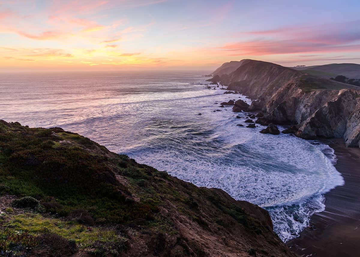
What visitors actually encounter is a landscape of unusual diversity packed into a single day trip. The southern ridges are draped in Douglas fir and bay laurel. The central valleys hold active cattle ranches that have operated here under special permit since before the park's creation. The open headlands are exposed to full Pacific winds, and the beaches range from sheltered coves to long surf-pounded stretches that are dramatic to walk and actively dangerous to swim. The Point Reyes Lighthouse, perched near the westernmost tip of the headland, sits at one of the foggiest and windiest spots on the entire U.S. Pacific Coast.
ℹ️ Good to know
Point Reyes is about 30 miles north of San Francisco but typically takes 75 to 90 minutes to reach by car due to winding two-lane roads through West Marin. Budget more time than the map suggests, especially on weekends.
The Lighthouse: Why Everyone Comes Here First
The Point Reyes Lighthouse sits at the end of Sir Francis Drake Boulevard, and most first-time visitors make it their primary destination. The structure was completed in 1870 to warn ships away from the fog-shrouded headland, which had already claimed dozens of vessels. Getting to the lighthouse involves descending roughly 300 steps from the parking area to the lighthouse platform — the NPS advises that those with heart or respiratory conditions should consider this before heading down. The descent is manageable for most visitors, but the return climb in wind and cold can surprise people who underestimated it.
The lighthouse itself is a compact Fresnel lens structure, and the views from the platform are genuinely striking: open ocean in three directions, sea stacks below, and on clear days a visual sense of how exposed this headland truly is. From late December through early April, this is one of the better shore-based whale-watching spots on the California coast, as gray whales pass during their annual migration. During peak whale season on weekends, the NPS operates a mandatory shuttle from Drakes Beach to the lighthouse parking area — private vehicles are not permitted at that time. Check the NPS site for current shuttle dates and schedules before you go.
⚠️ What to skip
The lighthouse area is frequently windy and cold, even in summer. Temperatures at the headland can be 10 to 15°F colder than inland and significantly cooler than San Francisco. Bring a windproof layer regardless of the city weather when you leave.
Tickets & tours
Hand-picked options from our booking partner. Prices are indicative; availability and final rates are confirmed when you complete your booking.
Point Reyes National Seashore self-guided driving audio tour
From 13 €Instant confirmationFree cancellationSelf-Guided Driving Tour of Point Reyes National Seashore
From 17 €Instant confirmationSonoma and Napa Valley wine tour from San Francisco
From 127 €Instant confirmationFree cancellationGo City | San Francisco Explorer Pass
From 76 €Instant confirmationFree cancellation
Wildlife: Tule Elk, Shore Birds, and Gray Whales
Point Reyes supports one of the most accessible large-mammal wildlife experiences in the Bay Area. The Tule Elk Reserve at Tomales Point, reached via the Pierce Point Road at the park's northern end, holds a free-ranging herd of tule elk — a subspecies native to California that was nearly extinct in the 19th century. The Tomales Point Trail (approximately 9.5 miles round trip) runs along the ridge above the ocean and through open grassland where elk are regularly visible, especially in morning light. During the autumn rut, the sound of bulls bugling carries across the hillside.
The esteros and tidal flats along Drakes Estero and Tomales Bay are significant stopover points on the Pacific Flyway, drawing waterfowl and shorebirds in large concentrations during migration seasons. Harbor seals haul out on sandbars inside Drakes Estero. The park's varied habitat — forest, grassland, wetland, and coast — produces a bird list that exceeds 490 recorded species, making it a consistent destination for serious birders.
For context on how Point Reyes fits into a broader outdoor itinerary, the San Francisco hiking guide covers nearby options including trails in the Marin Headlands and Mount Tamalpais, both of which can be combined with a Point Reyes day trip.
Beaches: What to Expect and What to Avoid
Point Reyes has several distinct beaches, each with a different character. Limantour Beach, reached via Limantour Road from the Bear Valley area, is a long barrier spit with relatively protected water on its inner side and open surf on the ocean side. It tends to be less exposed to wind than the headland beaches and is popular for walking and picnicking. The sand is fine and pale, and low tide reveals a wide, firm foreshore that feels genuinely remote despite the park proximity to the city.
Drakes Beach sits in a horseshoe bay below white cliffs and offers more wind protection than most of the park's shoreline. It has restroom facilities and a visitor center that is open on a seasonal schedule. Point Reyes Beach (also called North Beach and South Beach on maps) is the long stretch of open Pacific coast running along the western side of the peninsula. This beach is visually impressive, wide, and often empty on weekdays — but it carries a consistent surf and rip current hazard. Swimming is strongly discouraged at Point Reyes Beach, and the NPS posts warnings accordingly. Walk here, photograph here, but treat the water as a spectacle rather than an invitation.
⚠️ What to skip
Rip currents and sneaker waves are documented hazards at Point Reyes Beach. The NPS advises visitors not to swim and to stay back from the wave zone. These warnings should be taken seriously — the surf conditions here are not comparable to protected bay beaches.
How the Experience Changes by Time of Day and Season
Early mornings at Point Reyes, particularly from October through May, often bring fog that sits low over the valleys while the ridges remain clear. The Bear Valley trail system in early morning is quiet in a way that feels unusual this close to a major metropolitan area — the only sounds are ravens, the occasional wind through the Douglas firs, and your footsteps on soft duff. By mid-morning on weekends, the parking areas at Bear Valley and the lighthouse fill quickly. Summer weekends can see the main lots reach capacity by 10 a.m.
The clearest, calmest days at Point Reyes tend to fall in late September and October, when the marine layer retreats and the light has the low-angle warmth of early autumn. June through August — San Francisco's nominal summer — is often the foggiest period at the headland, and the lighthouse can be completely socked in. That is not necessarily a reason to avoid it; the drama of fog curling over the cliffs has its own appeal for photography, but visibility may be near zero.
Winter weekdays can be the best time of all. The ranching roads and forest trails hold almost no one, the elk are more easily approached along Tomales Point, and the whale-watching window begins in late December. Rain does not shut the park down, and the wet-season green of the hills against the gray Pacific is a specific visual reward that summer visitors miss entirely.
If you are planning a larger West Marin loop, Point Reyes pairs naturally with a stop in Muir Woods and a drive through the Marin Headlands — a combination that covers three distinct ecosystems in a single long day.
Getting There: The Honest Logistics
There is no direct public transit connection from San Francisco to the main visitor areas of Point Reyes. The West Marin Stagecoach Route 68 operates limited service connecting San Rafael (accessible via Golden Gate Transit bus or SMART train from the city) to Point Reyes Station and some park trailheads, but schedules are infrequent and the service does not cover the lighthouse or main ocean beach areas directly. For most visitors, a car is the practical necessity.
From San Francisco, the main driving routes are Highway 1 through Marin (scenic but slow) or Sir Francis Drake Boulevard via San Anselmo. Both are two-lane roads with limited passing opportunities and occasional weekend congestion near the headland. GPS often underestimates travel time on these routes. Plan for 75 to 90 minutes from central San Francisco under normal conditions, longer on summer and fall weekends. Fuel up before leaving the city or in Fairfax/San Anselmo — gas options thin out in West Marin.
Point Reyes is one of the more rewarding day trips from San Francisco, especially when combined with a stop in the town of Point Reyes Station for lunch before or after the park.
Who This Attraction Is Not Right For
Visitors with very limited mobility will find Point Reyes more restricted than the average national park. The lighthouse involves that steep staircase descent. The beaches require walking across soft sand. Most of the wildlife-watching areas involve unpaved trails of moderate length. The Bear Valley Visitor Center and a few paved paths near it are accessible, but the park's highlights are spread across a large, rugged landscape.
Point Reyes is also not a strong choice for visitors seeking the kind of guaranteed visual payoff that a single famous viewpoint delivers. The experience here is cumulative and environmental — it builds across an hour of walking, a shift in weather, the sudden appearance of elk on a ridgeline. If you are looking for a quick photo stop on a packed itinerary, the drive and time investment may not balance out. For a first-time visitor to San Francisco with only two or three days, other closer attractions may take priority. But for anyone with a full spare day and an interest in landscapes that feel genuinely unmanaged, few places within reach of the city come close.
First-time visitors working out how Point Reyes fits into a broader San Francisco trip can find scheduling advice in the 3-day San Francisco itinerary guide, which outlines how to balance city highlights with day trip options.
Insider Tips
- The Tomales Point Trail to the Tule Elk Reserve is significantly less visited than the lighthouse on weekends. Start at the Pierce Point trailhead by 8 a.m. to have the elk and the ridge views largely to yourself.
- Drakes Beach is the most wind-sheltered of the main beaches. If the headland is blowing hard — which it often is — Drakes is where you can actually sit down and eat lunch without holding your food.
- The Bear Valley Visitor Center has well-informed rangers and a free wall map that is more useful than most phone apps in an area with patchy cell service. Stop here first even if you think you know where you are going.
- If you are visiting during whale season (late December through April), check the NPS website for weekend shuttle dates well in advance. On shuttle weekends, you cannot drive to the lighthouse — the shuttle runs from Drakes Beach and the timing affects your entire day plan.
- Point Reyes Station, the small town at the park's eastern edge, has a good butcher, a well-stocked grocery, and a bakery. Picking up food here for a trail lunch is more practical and better quality than anything available inside the park itself.
Who Is Point Reyes National Seashore For?
- Hikers and trail runners looking for serious mileage in coastal terrain within a day of San Francisco
- Wildlife photographers, particularly during the autumn elk rut or the gray whale migration window
- Birders working the Pacific Flyway: the esteros and tidal flats concentrate species numbers that rival dedicated birding refuges
- Travelers who want open space and genuine quiet after a few days in the city
- Families with older children who can manage moderate trail distances and have an interest in natural history
Nearby Attractions
Combine your visit with:
- 16th Avenue Tiled Steps
The 16th Avenue Tiled Steps Project is a community-made mosaic staircase of 163 steps stretching through San Francisco's Golden Gate Heights neighborhood (a sub-area of the Inner Sunset), depicting a journey from the ocean floor to the night sky. It's free, photogenic, and connects to one of the city's best lesser-known hilltop viewpoints.
- Angel Island State Park
Angel Island State Park sits in the middle of San Francisco Bay, offering miles of hiking trails, layers of military and immigration history, and 360-degree views of the city skyline, Marin headlands, and beyond. Getting there requires a ferry, which is part of the appeal — the island feels removed from city life, even though San Francisco is visible the entire time.
- Asian Art Museum of San Francisco
One of the largest Asian art collections in the Western world, housed in a transformed Beaux-Arts landmark at Civic Center. From ancient Chinese bronzes to contemporary Southeast Asian installations, the museum rewards careful visitors who know what to look for.
- UC Berkeley Campus
The University of California, Berkeley sits on a hillside above San Francisco Bay, offering free access to striking Beaux-Arts architecture, landmark museums, and open green spaces. A short BART ride from San Francisco, it rewards curious visitors with history, intellectual energy, and some of the best campus scenery in the country.