Kitekite Falls: Piha's Towering Rainforest Waterfall
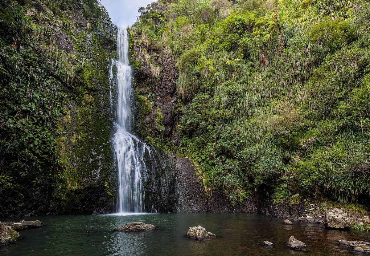
Kitekite Falls drops 40 metres into a rock pool at the edge of the Waitākere Ranges, just inland from Piha Beach. entry is free. Combine it with a beach visit for one of the most rewarding half-days on Auckland's West Coast.
Quick Facts
- Location
- 105 Glen Esk Road trailhead, Piha, Auckland; park at the beach car park and walk down Glenesk Road
- Getting There
- Drive to Piha via State Highway 16 and Scenic Drive; park at the beach car park and walk down Glenesk Road to the trailhead. No direct public transport to the trailhead; a car is the practical option.
- Time Needed
- 1.5 to 2.5 hours return, including time at the falls
- Cost
- Free; no admission charge
- Best for
- Families, hikers, photographers, and anyone combining the walk with a Piha beach day
- Official website
- www.aucklandnz.com/explore/kitekite-falls-path
What Kitekite Falls Actually Is
Kitekite Falls is a 40-metre waterfall in the Waitākere Ranges Regional Park, reached by a short bush track that begins at the end of Glen Esk Road in Piha. The waterfall drops in a broad curtain over dark basalt rock into a pool at the base, framed on all sides by dense native bush: tree ferns, kahikatea, and tawa that block out the sky and hold the air cool even on warm summer afternoons.
This is not a long or demanding walk. Most visitors reach the falls in 30 to 40 minutes one way from the trailhead, making it accessible to anyone with moderate fitness. That said, the track is not wheelchair-friendly: it follows formed gravel paths and boardwalks, and involves uneven ground and stream crossings. Children who can handle a forest walk do well here.
⚠️ What to skip
Stream crossings on this track can become hazardous after heavy rainfall. If Auckland has had significant rain in the 24 to 48 hours before your visit, check conditions before setting out and be prepared to turn back. Flash flooding is a real risk in the Waitākere Ranges.
The Walk In: What to Expect Underfoot
The track starts at the trailhead at 105 Glen Esk Road, reached by parking at the beach car park and walking down Glenesk Road, and follows Glen Esk Stream into the forest almost immediately. The transition from the road into the bush is abrupt: within a few minutes, the sound of the road disappears and is replaced by birdsong and the steady note of running water. The track surface alternates between compacted gravel, timber boardwalk over muddier sections, and exposed tree roots closer to the falls.
Stream crossings are part of the route. In dry conditions, they are generally easier to negotiate; after rain, do not attempt to cross if the water is high. Wear shoes with grip: trail runners or sturdy walking shoes are fine. Jandals or flat sneakers are a poor choice, especially after wet weather.
The final approach to the falls involves a steeper section and a viewpoint from which the full height of the drop becomes visible. Getting to the pool at the base requires care on wet rock. The spray radius is wider than it looks from a distance, so cameras and phones will collect mist quickly once you move close.
Tickets & tours
Live prices and dates from our booking partner. If you book, we may earn a commission at no extra cost to you.
Luggage Storage in Auckland
From 5 €Instant confirmationFree cancellationNew Zealand West Coast discovery tour
From 100 €Instant confirmationFree cancellation13,000ft skydiving experience in Auckland
From 195 €Instant confirmationFree cancellationDiscover Auckland City Tour
From 88 €Instant confirmationFree cancellation
The Falls Themselves: Scale, Sound, and Sensation
At 40 metres, Kitekite Falls is genuinely tall. Height alone does not always translate into an impressive waterfall experience, but here the combination of scale, the narrowness of the gorge, and the acoustics of the surrounding rock face makes the falls feel substantial. In higher flow conditions (typically winter and early spring, or after rain), the curtain widens and the roar carries back along the track well before you reach the pool.
In summer, when flow is lower, the falls are quieter and more delicate: a series of separate threads rather than a single mass of water. Both states have their appeal, but the high-flow version is more dramatic. If you visit in late June or July after rain and the track is safe, the falls can be at their most powerful.
The pool at the base is cold. People do swim here, particularly in summer, but the water temperature rarely rises significantly even after weeks of warm weather. Bring a towel if you want to attempt it, but do not treat this as a reliable swimming destination in the way that a beach would be.
Time of Day and Crowds
The carpark at Piha Beach is the visitor parking option for the trail. On summer weekends and public holidays, arrive early to improve your chances of finding a space. Arriving before 9am gives you a quieter track and the falls in soft morning light filtered through the canopy. This is also when birdlife is most active: kererū (New Zealand wood pigeon) move through the upper canopy, and you may hear tūī in the flowering trees.
Midday in summer brings the largest crowds, especially when combined with nearby Piha Beach. The track is narrow in places, and passing other groups at the stream crossings can feel awkward during peak hours. Late afternoon visits (after 3pm on a weekday) tend to be significantly quieter and have the advantage of the bush lighting up golden before dusk.
💡 Local tip
If you are visiting Piha Beach on the same day, do the Kitekite Falls walk first thing in the morning, then head to the beach. The walk takes 1.5 to 2.5 hours, and by the time you are done, the beach crowd will still be manageable.
Ecological and Cultural Context
Kitekite Falls sits within the Waitākere Ranges Regional Park, a 16,000-hectare forested range that forms Auckland's western boundary. The ranges are significant to mana whenua, particularly Ngāti Whātua and Te Kawerau ā Maki, who have lived in and travelled through this landscape for centuries. The name 'Kitekite' is believed to relate to the Māori word for 'to see' or 'viewing', though no single authoritative origin story is documented in current tourism sources.
The forest here is predominantly mixed podocarp-broadleaf native bush, including species such as tawa, kahikatea, and tree ferns. The Waitākere Ranges are also subject to kauri dieback disease (caused by Phytophthora agathidicida). On tracks within Controlled Area Notices, visitors must use the cleaning stations at track entrances and exits and ensure footwear and equipment have no visible soil. Kitekite Falls is outside the main kauri zones, but check and follow the signs and hygiene instructions at the trailhead.
ℹ️ Good to know
Kauri dieback disease is devastating New Zealand's ancient kauri trees. On tracks covered by a Controlled Area Notice, use the boot-cleaning stations and follow the posted instructions. The spores travel on soil particles.
Getting There and Combining with Other Stops
Piha is approximately 40 to 45 minutes by car from central Auckland via the Northwestern Motorway (SH16) and Scenic Drive. There is no direct public transport to the Kitekite Falls trailhead. If you do not have a car, you can check private tour operators that include West Coast beach and waterfall combinations. Renting a car for a day is the most flexible option for this part of Auckland's coastline. The Auckland West Coast beaches guide covers the wider area and can help you plan the full day.
Piha Beach is five minutes' drive from the Glen Esk Road carpark, making it the obvious pairing for a half-day or full-day trip. Piha Beach is one of the most photographed surf beaches in New Zealand, with Lion Rock as its landmark and lifeguard patrols during summer months. The two together form a complete West Coast experience without needing to move far.
If you want more variety, Muriwai Beach and its gannet colony are about 30 minutes north of Piha by car. Combining all three in a single day is possible but rushed. Kitekite Falls and Piha Beach alone fill a comfortable half-day without any sense of hurrying.
Photography Notes
The falls photograph best in overcast conditions. Flat light eliminates the harsh shadows that direct sun creates in a narrow gorge, and the waterfall's white curtain retains detail rather than blowing out. Overcast days are common in the Waitākere Ranges year-round, so do not be discouraged by grey skies on the drive over.
A wide-angle lens captures the full height of the falls within the gorge frame. If you are shooting on a phone, step back further than feels natural and use portrait mode sparingly as the depth cues in a gorge can confuse computational bokeh. A slow shutter speed (1/4 second or longer) smooths the water into the silk-like effect common in waterfall photography, though you will need a tripod or a stable rock surface to hold the camera steady.
Spray is the main practical problem. Bring a microfibre cloth to wipe the lens repeatedly, and keep your bag or camera case closed between shots. The pool at the base is the closest shooting position and yields the most dramatic perspective, but also the most spray.
Who Should Reconsider This Visit
Anyone with limited mobility will find this track difficult. The surface is uneven, stream crossings require stepping on rocks, and there are no accessible facilities at the trailhead. This is not a walk that can be partially completed to reach a viewpoint in most conditions. If mobility is a concern, the Piha beach area itself offers far better accessibility.
Visitors who have driven a long way hoping for a swimming hole destination may be disappointed. The pool is cold, not always deep enough for swimming depending on season, and there are no changing facilities. If a warm swim is the goal, there are better options closer to the city. And if you are visiting on a busy summer Sunday with no tolerance for other people on a narrow forest track, manage expectations: this is a popular walk by Waitākere Ranges standards.
Insider Tips
- The trailhead is reached by parking at the Piha Beach car park and walking down Glenesk Road; the road has residents-only vehicle access, so do not drive or park along it.
- Bring a waterproof layer even in summer. The forest canopy drips long after rain stops, the spray zone near the falls is significant, and afternoon showers are common in the Waitākere Ranges with little warning.
- The light inside the gorge is quite low. If you are shooting on a phone and finding photos blurry, switch to the standard lens rather than ultra-wide (which performs worse in low light on most phones) and brace your elbows against your body to stabilise.
- Combine Kitekite Falls with a walk along Piha Beach for a more complete day. Lion Rock remains a landmark, but its summit is closed; together, the falls walk and beach visit make a West Coast day out.
- Check the Auckland Council's park conditions page before any visit to the Waitākere Ranges after heavy rain. Some tracks in the region are closed after significant rainfall and the page is updated regularly.
Who Is Kitekite Falls For?
- Families with children who can manage a forest walk of about an hour each way
- Photographers looking for a native bush waterfall within day-trip distance of Auckland
- Hikers wanting to pair a bush walk with a surf beach visit in a single day
- Travellers on a tight budget who want a genuinely impressive natural attraction at no cost
- Anyone spending a day on Auckland's West Coast who wants more than just the beach
Nearby Attractions
Other things to see while in Piha:
- Karekare Beach
Karekare Beach sits inside the Waitākere Ranges Regional Park, about an hour's drive from central Auckland. This narrow, black-sand beach backed by forest-covered cliffs is free to visit, demands a little effort to reach, and rewards those who make the trip with one of the most striking coastal settings in the Auckland region.
- Piha Beach
Piha Beach sits on Auckland's Waitākere coast, about 40 minutes from the city, where black ironsand meets the Tasman Sea with relentless force. Dominated by the 101-metre volcanic monolith Lion Rock, it is the kind of place that makes you feel small. Free to visit, dramatic in any weather, and deeply connected to Māori history, Piha is unlike anything else within reach of a major New Zealand city.
- Waitākere Ranges Regional Park
Stretching west of Auckland city, Waitākere Ranges Regional Park protects 16,000 hectares of native rainforest. Known in te reo Māori as Te Wao Nui a Tiriwa, the Great Forest of Tiriwa, this park combines dramatic ridge-top views, ancient kauri remnants, and wild black-sand surf beaches within 40 minutes of the CBD.
Planning a trip? Discover personalized activities with the Nomado app.