Kew Mae Pan Nature Trail: Doi Inthanon's Most Rewarding Walk
The Kew Mae Pan Nature Trail is a 3-kilometre loop at the summit zone of Doi Inthanon National Park, winding through cloud forest and open ridgelines above 2,200 metres. On clear days, the views stretch across layered mountain ranges into Myanmar. This is one of northern Thailand's finest short hikes, and one of the coldest places you will stand in the country.
Quick Facts
- Location
- Doi Inthanon National Park, Chom Thong District, Chiang Mai Province
- Getting There
- Private car or tour from Chiang Mai city (approx. 100 km); no public transport reaches the trailhead directly
- Time Needed
- 1.5 to 2 hours including the walk and time at viewpoints
- Cost
- National park entry fee required (foreigners: 300 THB); no separate trail fee applies — guide fee may be separate
- Best for
- Hikers, nature photographers, anyone wanting a genuine mountain experience in northern Thailand
What Kew Mae Pan Actually Is
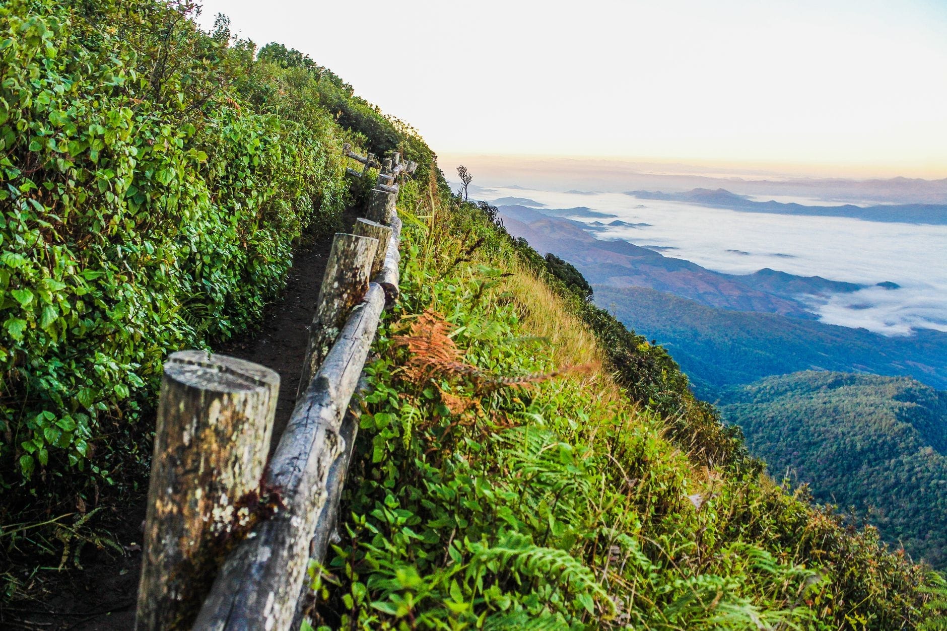
The Kew Mae Pan Nature Trail is a circular walking route that loops around the southern ridge of Doi Inthanon, Thailand's highest peak at 2,565 metres. The trailhead sits a short drive below the summit, and most of the walk takes place above 2,200 metres, placing it firmly in subalpine cloud forest territory. This is not a technical climb. It is a well-maintained path through a landscape that feels genuinely unlike anything else in Southeast Asia: dwarf trees draped in lichen and moss, open grassland stretching along exposed ridges, and sudden clearings where the terrain drops away and the views reach for miles.
The trail earned its reputation for good reason. Unlike the summit of Doi Inthanon itself, which is forested and offers no view, Kew Mae Pan delivers both forest immersion and open panoramas on the same walk. On a clear morning between October and February, the mountains of the Thai-Myanmar border range appear as faint blue ridges in the distance. Wildflowers colour the grassland sections, and the air at this elevation carries a real chill that feels foreign to a country most visitors associate with heat.
ℹ️ Good to know
The trail is officially closed from June through October during the rainy season. Outside these months, a local Hmong guide is required to accompany your group. Guides are stationed at the trailhead and assigned automatically at no additional cost beyond the guide fee.
The Walk: What to Expect Section by Section
The loop runs approximately 3 kilometres and takes most walkers between 1.5 and 2 hours to complete, not counting time spent at viewpoints. The path is well-marked and the elevation change is modest, with a few short ascents over rocky sections but nothing that requires hiking experience. A pair of trail runners or light hiking shoes is adequate. Flip-flops are a bad idea: the path is uneven in places and can be slippery with morning dew.
The first section of the trail moves through dense cloud forest, where the trees are short and twisted from wind and cold, and every surface is coated in pale green moss. Sound drops out here. The forest absorbs it. You will hear birdsong, the occasional drip of condensation from leaves, and almost nothing else. This section takes roughly 20 to 30 minutes before the treeline opens.
The middle section along the exposed ridge is where most photographs are taken. The views are widest here, and on clear days the drop in elevation creates a sense of standing at the edge of something large. This is also where the wind picks up sharply, and where a jacket becomes necessary rather than optional. The grassland edges in this section support a rotating cast of wildflowers depending on the season, with varieties that bloom specifically in the cool-dry period between November and February.
The final section returns through forest, completing the loop near the trailhead. Many visitors choose to linger on the ridge rather than rushing through, which is the correct instinct. The total walking distance is short enough that there is no need to rush.
💡 Local tip
Arrive at the trailhead before 8:00 AM to walk the ridge section in morning light before clouds build. By mid-morning on many days, mist rolls in from the valleys and obscures the long views, though it creates its own atmosphere.
Tickets & tours
Hand-picked options from our booking partner. Prices are indicative; availability and final rates are confirmed when you complete your booking.
Half-day tour to admire elephants and enjoy Thai nature
From 48 €Instant confirmationFree cancellationPrivate Mae Hong Son highlights car tour from Pai
From 175 €Instant confirmationFree cancellationExperience Lampang's culture with private van and driver
From 132 €Instant confirmationFree cancellationMae Kampong village full-day trip with private transfer
From 132 €Instant confirmationFree cancellation
Best Time to Visit and Weather Realities
The trail operates from November 1 through May 31, with the best conditions falling between November and February. During these months, the air is clear, the temperature at the trailhead ranges from roughly 5 to 15 degrees Celsius in the morning, and the wildflowers along the ridge are at their most varied. This is also when Doi Inthanon receives the highest visitor numbers overall, so arriving early matters both for views and for parking.
March and April bring warmer temperatures and drier conditions, but also the beginning of smoke season across northern Thailand. On days when agricultural burning is active in the lowlands, the distant views from the ridge can disappear entirely into haze. If you are visiting during this period, check the Air Quality Index before making the drive up. For a full picture of northern Thailand's seasonal patterns, the Chiang Mai burning season guide explains what to expect and when conditions typically clear.
The rainy season closure from June through October is genuine and enforced. The trail becomes dangerously slippery and the vegetation is too sensitive to absorb foot traffic during this period. Do not attempt to walk it outside the official open season.
Getting to Kew Mae Pan
There is no public transport to the Kew Mae Pan trailhead. The practical options are renting a car or motorbike from Chiang Mai and driving the 100-kilometre route yourself, joining an organised day tour that includes Doi Inthanon, or hiring a private driver for the day. The drive from Chiang Mai takes approximately 2 to 2.5 hours depending on traffic and the pace of the mountain road. The route is straightforward and well-signposted once you enter the national park.
The trailhead for Kew Mae Pan sits a few kilometres below the Doi Inthanon summit, past the Twin PagodasRoyal Twin Pagodas on the main park road. Most visitors combine the trail with the pagodas and a stop at the summit on the same day. This is a sensible approach given the distance from the city, but it means arriving early to complete the nature trail while views are still clear before crowds gather at the other sites.
If you are planning a full day on the mountain, the Doi Inthanon day trip guide covers route planning, timing, and what else is worth seeing inside the park.
Photography on the Trail
The ridge section provides the most dramatic landscape photography, particularly in the first two hours after sunrise when low light crosses the mountain ridges from the east and long shadows define the terrain. A wide angle lens captures the grassland and sky; a telephoto is useful for picking out the distant ranges on clear days. The cloud forest sections are better for close-up and macro work: lichen textures, moss-covered branches, and wildflower detail.
The entire Doi Inthanon area rewards careful photographers willing to time their visit well. The Chiang Mai photography guide includes notes on the best conditions and timing for this part of the park.
⚠️ What to skip
Bring a lens cloth. Condensation from the cloud forest coats optics quickly, especially in the cooler months when temperature differences between forest interior and open ridge are significant.
Practical Details and What to Bring
Dress in layers. The temperature difference between the national park gate and the trailhead is noticeable, and the wind on the exposed ridge makes it feel colder than the ambient temperature suggests. A light fleece or packable jacket is sufficient for most visitors in December and January, but a warmer layer is advisable in the coldest weeks of the cool season when temperatures near the summit can approach freezing overnight.
Bring water and a snack. There are no refreshment stalls at the trailhead itself, though facilities exist at other stops within the park. Sun protection matters on the open ridge sections even in cool weather. The elevation reduces UV filtering, and the open grassland provides no shade for a significant portion of the walk.
The trail is accessible to most reasonably fit walkers, but uneven rocky sections and the absence of handrails on steeper parts mean it is not suitable for those with limited mobility. The ranger accompaniment requirement is standard and not negotiable: rangers wait at the trailhead and groups do not proceed without one. This system also ensures someone familiar with the terrain is always present, which is practical on a high-altitude trail subject to rapid weather changes.
💡 Local tip
Tell the ranger your preferred pace at the start. Rangers walk at different speeds and some are more informative than others. A brief conversation at the beginning tends to produce a more engaging walk.
Who This Trail Is Not For
Visitors who dislike cold weather, who are not comfortable on uneven terrain, or who are expecting a dramatic summit experience should calibrate expectations. The trail is not technically challenging, but the altitude and temperature genuinely affect comfort. Visitors who arrive at midday during the dry season frequently find the ridge views obscured by cloud and the trail uncomfortably windy without reward.
Families with very young children should consider whether the uneven rocky sections and the mandatory pace of a ranger-guided group suits their needs. Older children who walk regularly will likely find it engaging. The wildflowers, unusual trees, and occasional bird sightings provide enough to hold attention on the slower sections.
Insider Tips
- If you are visiting between late November and early February, start the drive from Chiang Mai by 5:30 AM to reach the trailhead before 8:00 AM. This is not excessive caution: the ridge views are genuinely better in the first two hours of the day before valley mist rises.
- Combine the trail with the nearby Royal Twin Pagodas and Wachirathan Waterfall on the same day trip to make the long drive from Chiang Mai worthwhile. Plan the nature trail first while you are fresh and the light is right, then visit the pagodas mid-morning.
- Rangers at the trailhead often have binoculars and are knowledgeable about bird species along the route. Doi Inthanon is a recognised birdwatching destination, and species not found at lower elevations in Thailand appear in this zone.
- The trail fee is paid separately from the national park entry fee. Carry cash in small denominations. The fee structure has changed in recent years, so confirm the current rate at the gate rather than relying on older sources.
- If the ridge is fully socked in with cloud when you arrive, wait 20 minutes before deciding to turn back. Clouds at this elevation move quickly and gaps appear with little warning, sometimes opening to full panoramic clarity within minutes.
Who Is Kew Mae Pan Nature Trail For?
- Hikers and trekkers wanting a short but genuine high-altitude walk without technical difficulty
- Nature photographers targeting cloud forest detail, wildflowers, and panoramic ridge light
- Visitors combining Doi Inthanon's main sites into a single well-organised day trip from Chiang Mai
- Birdwatchers: the trail passes through habitat supporting species endemic to the upper elevation zones of northern Thailand
- Travellers who want to experience genuine cold weather in Thailand, particularly in December and January
Nearby Attractions
Other things to see while in Doi Inthanon National Park Area:
- Doi Inthanon Royal Twin Pagodas
Set high on the slopes of Thailand's tallest mountain, the Royal Twin Pagodas are two elaborately decorated chedis surrounded by manicured gardens and often wreathed in mist. Built to honor King Bhumibol Adulyadej and Queen Sirikit, they represent some of the finest contemporary Lanna Buddhist craftsmanship in northern Thailand.
- Doi Inthanon Summit
At 2,565 metres above sea level, the Doi Inthanon summit is the highest point in Thailand. The peak sits inside Doi Inthanon National Park, roughly 70 kilometres southwest of Chiang Mai, and draws visitors for its cloud forest ecology, dramatically cooler temperatures, and the sense of standing above everything else in the country.
- Wachirathan Waterfall
Wachirathan Waterfall is the largest and loudest waterfall in Doi Inthanon National Park, dropping over 80 metres in a wide curtain of white water that generates a constant cool mist. Set deep in montane forest roughly 21 kilometres from the park entrance, it rewards visitors with raw natural power rather than picture-perfect serenity.