Doi Ang Khang Royal Agricultural Station: Chiang Mai's Cool-Climate Garden on the Myanmar Border
Doi Ang Khang Royal Agricultural Station sits at roughly 1,400 metres on a ridge that edges the Myanmar border, where the air carries a genuine chill and the hillsides bloom with temperate flowers rarely seen elsewhere in Thailand. It is part royal garden, part agricultural research centre, and part window into the hill tribe communities that have called this plateau home for generations.
Quick Facts
- Location
- Doi Ang Khang, Fang District, Chiang Mai Province — approximately 150 km north of Chiang Mai city
- Getting There
- Private car or hired driver via Highway 107 to Fang, then Route 1249 up the mountain. No direct public bus reaches the station; travellers usually transfer from Chiang Mai–Fang buses to local pickup trucks for the final climb.
- Time Needed
- 4–6 hours on site; most visitors combine with an overnight stay in the area
- Cost
- Entry fee applies (verify current rate at the gate). Camera fees may be charged separately for certain garden zones.
- Best for
- Garden lovers, cool-weather seekers, photographers, families wanting a scenic drive, and travellers interested in royal development projects
What Doi Ang Khang Actually Is
Doi Ang Khang Royal Agricultural Station is not a national park and not a conventional tourist garden. It is a working research station established by royal initiative in 1969, when King Bhumibol Adulyadej visited the area and proposed replacing opium poppy cultivation with temperate fruits, vegetables, and ornamental crops. That original mission still operates today: agronomists study cold-climate cultivars, hill tribe communities receive training in sustainable farming, and the station's gardens serve as a living demonstration of what grows at altitude in northern Thailand.
The result, for a visitor, is an unusual place: manicured flowerbeds share the hillside with working orchards of peaches, plums, and kiwi fruit. Research plots sit beside open lawns where Thai families picnic under strawberry-shaped parasols. There is a formality to the main garden areas, and a rawness to the surrounding ridgeline and border scenery. Neither element overwhelms the other, which is what makes Doi Ang Khang worth the long drive.
ℹ️ Good to know
The station sits within a controlled border zone near Myanmar. Visitors must carry their passport or Thai ID. Foreign nationals are generally permitted entry to the station grounds but movement beyond designated areas may be restricted. Confirm current regulations with your accommodation or driver before visiting.
The Gardens: Flowers, Orchards, and Research Plots
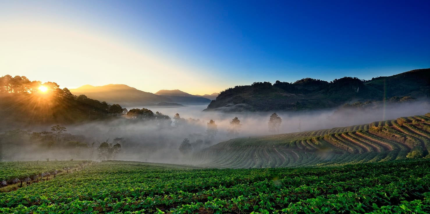
The centrepiece of any visit is the ornamental garden area, which peaks between late November and early February. During these months, the beds fill with cherry blossoms (a variety that needs the cool temperatures Doi Ang Khang provides), roses, dahlias, salvias, and flowering brassicas in dense, organized rows. The colour concentration on a clear morning, with mist still sitting in the valleys below the ridge, is genuinely striking.
Outside the peak flowering season, the gardens are quieter and the palette more muted, though the topiary and rose sections maintain structure year-round. The fruit orchards are worth walking through in summer, when peaches and plums are on the branch. Some produce is sold at the station's small shop, and buying directly supports the agricultural programme.
Photography works best in the morning, before visitor numbers build and before the midday light flattens the colour. Bring a lens that lets you work tight inside the flower rows, and a wider option for the ridgeline views behind the main garden area. If you arrive in late afternoon, the low-angle light catches the flowers well but you will have less time before closing.
💡 Local tip
The flowering calendar shifts by a few weeks each year depending on rainfall and temperature. If cherry blossoms are your priority, check current conditions via Thai royal project social media accounts or call the station directly before making the drive.
Tickets & tours
Hand-picked options from our booking partner. Prices are indicative; availability and final rates are confirmed when you complete your booking.
Chiang Mai private van day trip to Doi Suthep, Sticky Waterfall
From 146 €Instant confirmationFree cancellationChiang Mai - Doi Inthanon full day tour
From 41 €Instant confirmationFree cancellationDoi Inthanon Trek tour in Chiang Mai
From 119 €Instant confirmationFree cancellationHalf-day private van tour to Doi Suthep and Doi Pui Hmong Village from Chiang Mai
From 93 €Instant confirmationFree cancellation
The Ridgeline, Border Views, and Getting Your Bearings
Beyond the gardens, Doi Ang Khang rewards walkers who venture toward the ridge. The viewpoint areas above the main station look north and west into Myanmar, with layered blue ridgelines receding into the distance on clear days. The air at this altitude is noticeably thinner and cooler than Chiang Mai city, typically around 15–20°C in the dry season and sometimes dropping close to or below 5°C on cold nights between December and January.
The surrounding terrain is steep and forested, and the roads that thread the plateau require careful driving, particularly on the descent via Route 1249. The access road climbs through sharp switchbacks, and the final approach to the station involves gradients that will stress an underpowered vehicle. Trucks and well-maintained SUVs handle it reliably; small city hatchbacks can manage but take the corners slowly.
⚠️ What to skip
Fog can close in rapidly above 1,000 metres, particularly from late afternoon in the cool season. If you are driving yourself, plan to descend well before dusk. The switchbacks on Route 1249 are unlit and the guardrails inconsistent.
Hill Tribe Villages and the Human Side of the Station
Several ethnic minority villages are located within or immediately adjacent to the station area, including communities of Shan, Yunnan Chinese (often called Chinese Haw), Lisu, and Palong people. The royal agricultural project brought these communities into its development framework, and some villagers work in the gardens or sell produce and handicrafts through the station's facilities.
The Chinese Haw village near the station is particularly distinctive: the architecture, food, and daily rhythms reflect the migrants who arrived from Yunnan following the end of the Chinese Civil War. Small restaurants in the village area serve yunnan-influenced dishes, and this is one of the practical reasons to build an overnight stay into your trip rather than rushing back to Chiang Mai the same day.
For broader context on the hill tribe communities found across this region, the Chiang Mai trekking guide covers the cultural background in detail. If you are pairing this visit with other northern sites, the northern Thailand travel guide maps out logical multi-day routes.
How to Get There and When to Go
The drive from Chiang Mai city takes approximately three to three and a half hours without stops, heading north on Highway 107 through Chiang Dao and continuing to Fang before turning west onto the mountain road. The journey itself is part of the experience: the road passes through the broad valley around Chiang Dao, with Doi Chiang Dao's limestone massif visible to the west, before the terrain tightens as you approach Fang.
If you are stopping en route, Chiang Dao Cave sits about halfway along and makes a logical mid-morning stop before continuing north. The cave is a significant site in its own right and breaks up what is otherwise a long single-purpose drive.
Songthaews from Fang town head toward the Doi Ang Khang area, but schedules are irregular and drop-off points may not reach the station entrance. A hired driver from Chiang Mai city for the day or a booked tour is the most practical option for foreign visitors without their own vehicle. If you are travelling by motorbike, the roads are paved but the gradients are demanding; a semi-automatic or larger-displacement bike is strongly recommended over a small scooter.
The peak season is November through February, when temperatures are coolest and the flowering is at its most dramatic. March to May is hotter and drier, with reduced floral interest. The rainy season from June to October makes the roads muddier and the mountain access less reliable, though the landscape turns intensely green.
For a fuller picture of how Chiang Mai's seasons affect travel decisions, the best time to visit Chiang Mai guide breaks down each month in detail.
Staying Overnight and What to Expect
The station operates its own accommodation in the form of bungalows on the hillside, bookable through the Royal Project Foundation. These fill quickly during the December and January peak, so advance reservation is essential. The bungalows are simple and clean, not luxurious, with the main draw being the morning experience: waking to cold air, watching the mist clear from the valley below, and having the gardens largely to yourself before the day-trip visitors arrive.
A small number of guesthouses and resorts have also developed in the wider Doi Ang Khang area. Standards vary considerably, and the access roads to some involve further steep driving. Pack warm clothing regardless of where you stay: even in the relatively mild November cool season, evenings at altitude can require a jacket that would feel absurd back in Chiang Mai city.
💡 Local tip
Pack more layers than you think you will need. Chiang Mai city's cool season temperatures give no reliable indication of how cold Doi Ang Khang gets after dark. A fleece and a windproof outer layer are practical minimums for December and January nights.
Who Should Reconsider
Doi Ang Khang requires genuine investment: a long drive, a border-zone entry process, and an entry fee to reach what is, outside the flowering peak, a pleasant but not spectacular garden. Travellers with only two or three days in Chiang Mai will almost certainly spend their time more efficiently elsewhere, given that the round trip alone consumes the better part of a day.
If your priority is mountain scenery combined with more established hiking infrastructure, Doi Inthanon sits closer to Chiang Mai city, reaches a higher summit, and has maintained trail networks. For a cooler-climate day trip with less driving, Doi Inthanon is the stronger choice for most visitors on a tight schedule.
Visitors who are not mobile enough for uneven garden paths and sloped terrain will find some areas inaccessible. The main garden paths are walkable but not flat, and some viewpoint areas require short climbs on unpaved ground. There is no wheelchair infrastructure to speak of.
Insider Tips
- Book station bungalows at least six to eight weeks ahead for the December to January peak. They sell out far earlier than most visitors expect, and there is no same-day availability.
- The strawberry growing plots near the entrance sometimes allow visitors to pick their own fruit during the season, typically January through March. Ask at the information point near the main gate.
- Yunnan-style noodle soup sold in the Chinese Haw village just outside the station makes a better breakfast than anything served in the station's own cafe. Walk down early before day-trip crowds arrive.
- If you want to photograph the cherry blossoms without crowds, arrive at gate opening and head directly to the blossom area before walking the rest of the gardens. By mid-morning, group tours dominate the blossom paths.
- The descent on the eastern route via Ban Luang, used in the first access option described by the Royal Project, is longer but smoother than retracing the main route. If you have a reliable vehicle and good daylight remaining, it adds little time and passes through a different landscape.
Who Is Doi Ang Khang Royal Agricultural Station For?
- Photographers targeting cool-season flowers and border-ridge landscapes
- Families looking for a scenic multi-day road trip into northern Chiang Mai province
- Travellers interested in royal development projects and their social impact
- Garden enthusiasts who want to see temperate horticulture in a tropical country
- Visitors building a multi-day loop that includes Chiang Dao and Fang
Nearby Attractions
Other things to see while in Chiang Dao:
- Chiang Dao Cave (Tham Chiang Dao)
Tham Chiang Dao is a vast limestone cave complex near the base of Doi Chiang Dao mountain, roughly 70km north of Chiang Mai. Some sections are lit and walkable independently; others require a local guide with a lantern. The experience blends natural geology with active Buddhist devotion in a way few caves in Southeast Asia manage.
- Mae Ngat Dam (Houseboat Area)
Mae Ngat Dam sits roughly 50–60 kilometres north of Chiang Mai in Mae Taeng District, forming a wide reservoir ringed by forested mountains. The attraction here is not the dam itself but the cluster of bamboo houseboats moored on the water, where visitors can sleep overnight, kayak at dawn, and eat fresh fish in near-total silence.