Deep Cove: North Vancouver's Waterfront Village at the End of Indian Arm
Deep Cove is a compact waterfront community in the District of North Vancouver, set where the mountains meet Indian Arm. Free to enter and easy to reach by car or transit, it offers kayaking, the Quarry Rock trail, and a walkable village strip within about 30 minutes of downtown Vancouver.
Quick Facts
- Location
- 4360 Gallant Avenue, North Vancouver, BC — 13 km from downtown Vancouver, at the foot of Mount Seymour
- Getting There
- TransLink bus from Phibbs Exchange or Seylynn Village; check TransLink trip planner for current routes
- Time Needed
- 2–4 hours for the village and Quarry Rock trail; full day if kayaking
- Cost
- Free to enter; kayak/canoe rentals and guided tours charged by individual operators (CAD, verify current rates)
- Best for
- Kayakers, hikers, families, photographers, and anyone wanting a genuine North Shore escape without a long drive
- Official website
- www.dnv.org/programs-and-services/deep-cove
Deep Cove at a glance
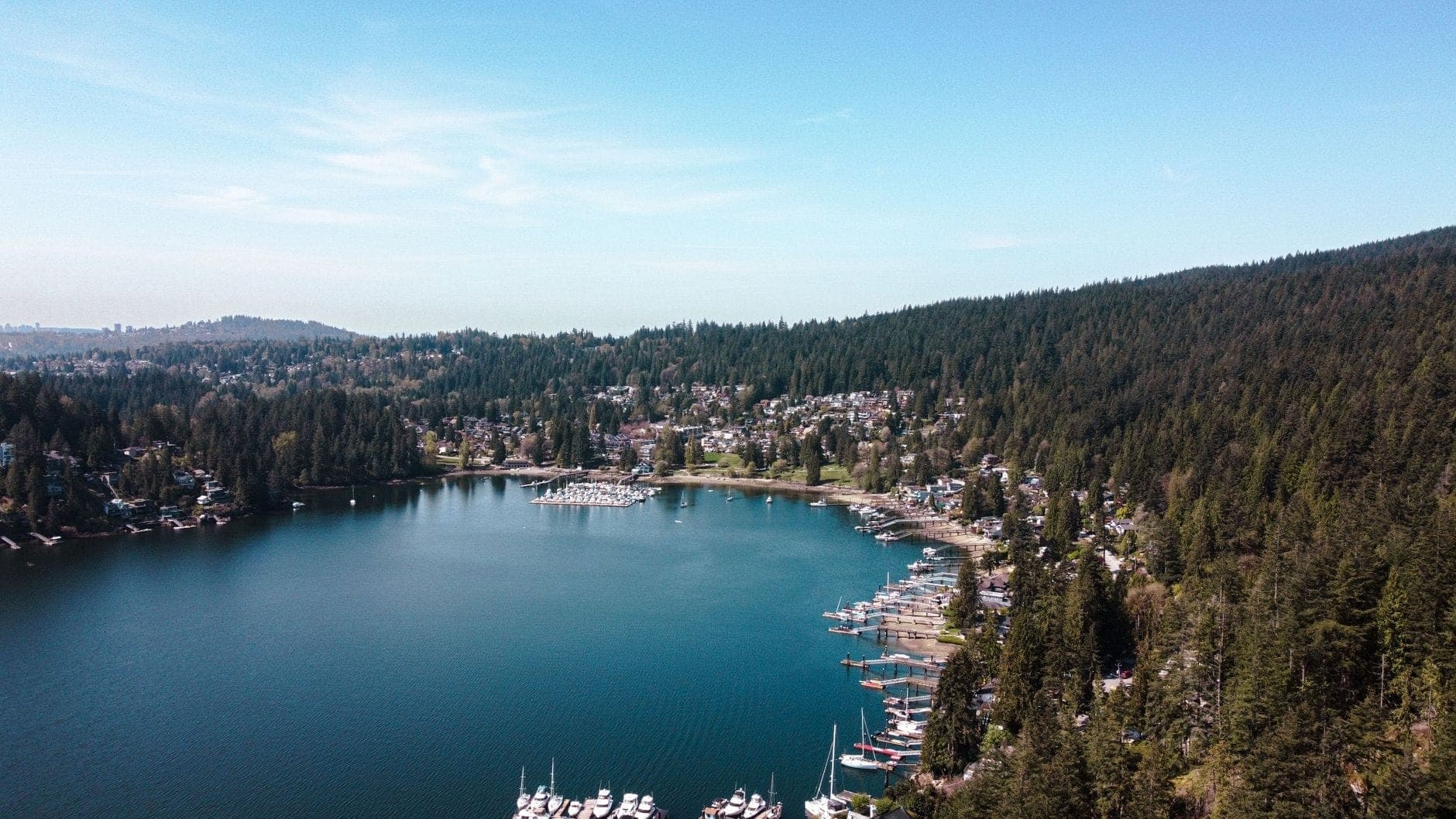
Deep Cove is not a park, a resort, or a ticketed attraction. It is a working waterfront community at the easternmost edge of the District of North Vancouver, sitting at the narrow head of Indian Arm, a glacially carved fjord that extends over 20 kilometres. The village strip along Gallant Avenue is small enough to walk end-to-end in ten minutes: a handful of independent cafes, kayak outfitters, a bakery that regularly draws a line, and a small public wharf.
The Tsleil-Waututh Nation, whose traditional territory includes this shoreline, know the area as Guy-angulton, meaning 'sheltered place' That description still holds. The cove is naturally protected by the surrounding hills, the water is calm even when the broader inlet is choppy, and the whole pocket feels removed from the city in a way that distances on a map do not predict. You are about 13 kilometres from downtown Vancouver, but the scale, noise level, and visual environment are entirely different.
ℹ️ Good to know
Deep Cove has no admission gate and no set opening hours. The community is publicly accessible at all times. Individual business hours, kayak rental windows, and parking lot operating times vary by season and operator — check ahead if you are planning around a specific activity.
The Village on Foot: What You Will See and Smell and Hear
Arriving from the parking area near Panorama Park, the first thing most visitors notice is the salt-and-cedar smell that is specific to sheltered inlets on the BC coast. The water here is still enough that you can hear the creak of kayak paddles and the lap of small wakes against the dock pilings. On summer mornings, the surface of Indian Arm reflects the ridgeline to the east before the sun climbs high enough to break the effect.
The bakery on Gallant Avenue, Honey Doughnuts & Goodies, has operated here for decades and produces a specific type of yeast-raised doughnut that generates a line from mid-morning onward on weekends. The line moves, and the doughnuts are genuinely good, but if you arrive at 10:30 on a Saturday in July expecting a quick grab, budget for a wait. Weekday mornings before 9 a.m. are a different experience entirely: quieter, cooler, and unhurried.
The strip of shops and eateries is independent and small-scale. There is no chain presence. Cafes here tend to have outdoor seating that faces the water, which means on clear days you get a straight sightline down Indian Arm toward the mountains in the distance. The overall visual register is greens and greys and the specific blue-grey of protected saltwater, with kayaks pulling colour into the frame.
Kayaking Indian Arm: The Main Draw
Kayaking is the activity most closely associated with Deep Cove, and the reason is straightforward: Indian Arm is protected, visually dramatic, and accessible to paddlers of almost all experience levels from the public launch at Panorama Park. The arm stretches north toward the mountains, and even a short paddle of 30 to 45 minutes will take you far enough from the village that the urban context disappears entirely.
Several outfitters operate from the waterfront and offer single and double kayak rentals, as well as stand-up paddleboard rentals and guided tours. Rates and seasonal hours vary; verify directly with operators before your visit. Beginners do not need prior experience for calm-conditions paddling close to the village, but conditions can change, and outfitters will brief you on protocols before you launch. Morning is the best window for calm water. Afternoon winds, particularly in summer, can pick up from the southwest and create surface chop that makes return paddling harder than anticipated.
💡 Local tip
If you plan to kayak, aim for an early start: 8–10 a.m. on summer days gives you calm water, cooler temperatures, and the best light on the mountains to the north. Afternoons on Indian Arm can see increased wind and chop.
Experienced paddlers sometimes continue further up Indian Arm toward Granite Falls or camp on the water's edge overnight. For context on the wider North Shore paddling and hiking environment, the Quarry Rock trail offers a complementary land-based perspective on the same fjord landscape.
Quarry Rock: The Trail That Earns the View
The most popular hike directly accessible from Deep Cove is the Quarry Rock trail in Panorama Park. The trailhead is a short walk from the village along Panorama Drive. The trail itself is approximately 3.8 kilometres round trip, gaining about 215 metres in elevation over forested ground with exposed tree roots and some rocky scrambling near the summit. It is not a technical hike, but it is uneven enough that trail shoes or hiking boots are strongly recommended over sandals or flat-soled shoes.
The payoff at the top is a granite outcrop with an unobstructed view down Indian Arm. On clear days the fjord stretches to the south with forested slopes rising sharply on both sides. It is a genuinely memorable view, earned in under an hour of walking. The trail is heavily used on weekend mornings: the narrow path can create bottlenecks in both directions, and the summit rock fills up quickly by mid-morning. A weekday visit, or arriving at the trailhead before 8 a.m. on weekends, gives you the view without the crowd management.
Deep Cove and Quarry Rock sit within the broader North Shore landscape. For other trails and outdoor options nearby, the guide to Grouse Mountain and the Lynn Canyon Suspension Bridge cover complementary North Shore destinations worth combining on a full day out.
How Deep Cove Changes by Time of Day and Season
Early morning, from opening time at the first cafe through about 9 a.m., Deep Cove is calm and unhurried. The water is at its smoothest, the light is low and warm in summer, and the village feels like a neighbourhood rather than a destination. Locals walking dogs and early kayakers launching are the primary population. This is the window most likely to feel genuinely peaceful.
By mid-morning on any dry weekend between May and September, the parking lots fill. Gallant Avenue becomes a slow procession of visitors, the doughnut line extends, and the kayak rental queue builds. This is still a pleasant place to be, but managing expectations about pace helps. The energy shifts from contemplative to social.
In autumn and winter, the crowd picture changes completely. Visitor numbers drop sharply after October. The trade-off is that the trees on the surrounding hillsides turn, the light on the water becomes low and golden in the late afternoon, and the whole cove takes on a quality that is harder to photograph but easier to actually experience. Rain is common from October through March. The trail to Quarry Rock becomes slippery when wet, and waterproof footwear is the practical choice rather than an optional upgrade.
⚠️ What to skip
Parking in Deep Cove is limited and fills quickly on summer weekends, often by 9:30 a.m. Consider arriving before 8:30 a.m. or using TransLink transit from North Vancouver to avoid the parking situation entirely. Uber and Lyft also operate in Metro Vancouver.
Getting There and Getting Around
By car from downtown Vancouver, the most direct route crosses the Second Narrows Bridge (the Ironworkers Memorial Bridge) and continues via the Trans-Canada Highway to Mount Seymour Parkway, then descending into the Deep Cove community. Total drive time is roughly 30 minutes without traffic congestion. The route is straightforward. Parking is available near Panorama Park and along residential streets, but volume on summer weekends makes early arrival important.
By transit, TransLink bus services connect Deep Cove to the broader North Shore network, including connections from Phibbs Exchange, which links to the SeaBus terminal at Lonsdale Quay in North Vancouver. The SeaBus runs between downtown Vancouver's Waterfront Station and Lonsdale Quay in about 12 minutes one way. Use the TransLink trip planner at translink.ca for current routes and schedules, as service details change periodically. For a broader orientation to transit options across Metro Vancouver, the getting around Vancouver guide covers the full picture.
Once in Deep Cove, everything of interest is walkable. The village, the wharf, Panorama Park, and the Quarry Rock trailhead are all within a ten to fifteen minute walk of each other. The terrain is gently sloped near the waterfront and steeper as you head inland toward the trail. Visitors with significant mobility limitations may find the Quarry Rock trail difficult due to roots, uneven surfaces, and gradient, but the waterfront area and village itself are manageable, though sidewalk grades and curb cuts vary.
Historical and Cultural Context
The area's Indigenous history is grounded in its geography. The sheltered water and forested shoreline made Guy-angulton a meaningful place for the Tsleil-Waututh and Squamish Nations long before European settlement. The colonial-era postal history is more recent: a summer post office named Deep Water opened in 1927, was renamed Deep Cove Post Office in 1940, and the community name Deep Cove was later adopted in BC geographical records.
The community has remained small by design and by geography. Hemmed in by the inlet to the south and east and by the slopes of Mount Seymour to the north and west, it never developed the density of other North Shore communities. This physical constraint is the main reason it retains the character it does. The village that exists today is genuinely similar in scale to what it has been for decades, which is either a feature or a limitation depending on what you are looking for.
Deep Cove sits within the broader North Shore context that includes communities from West Vancouver through to the Seymour area. For a wider overview of what the North Shore offers, the North Shore Vancouver neighbourhood guide provides useful orientation.
Who Might Want to Skip This
Deep Cove is not the right destination for visitors whose priority is urban sightseeing, cultural institutions, or concentrated dining options. The village strip is short, the number of shops is small, and the primary draws are outdoor and sensory rather than curatorial. If you are on a single-day itinerary focused on downtown Vancouver attractions and have limited time, Deep Cove requires enough travel and time investment that it may not fit.
It is also not a particularly fair-weather fallback. The Quarry Rock trail is genuinely less enjoyable in heavy rain, and the waterfront loses much of its appeal when visibility is poor. In those conditions, the case for making the trip is weaker. Check the forecast before committing a weekend morning to it.
Insider Tips
- The doughnut line at Honey Doughnuts moves faster than it looks, but on summer weekends it can still mean a 20-minute wait. Order coffee elsewhere first, then join the queue — the timing works out more efficiently than standing in place.
- The public wharf at the end of Gallant Avenue is worth walking to even if you are not kayaking. Harbour seals regularly haul out on the dock floats, particularly in the morning before boat traffic picks up.
- For the Quarry Rock trail, the trailhead signage is easy to miss if you are unfamiliar with the area. From Panorama Park, follow Panorama Drive northeast on foot — the Baden Powell Trail entrance is clearly marked once you are on the right road.
- Autumn visits, particularly October to early November, offer the lowest crowds and the best foliage colour on the surrounding hillsides. The water is glassy in the mornings and the low-angle light makes photography significantly more rewarding than the flat midday light of summer.
- If you are combining Deep Cove with other North Shore stops, note that the drive from Deep Cove to the Capilano Suspension Bridge takes approximately 30 minutes without traffic. Doing both in a single day is workable if you start early and are selective about how long you spend at each.
Who Is Deep Cove For?
- Kayakers and paddleboarders looking for calm, scenic water close to Vancouver
- Hikers wanting a short but rewarding trail with a genuine fjord viewpoint
- Families with children who can manage a moderate 3-4 km round-trip hike
- Photographers working with natural landscape and water subjects
- Visitors who want a half-day break from the city without leaving Metro Vancouver
Nearby Attractions
Other things to see while in North Shore:
- Capilano Suspension Bridge
Stretching 137 metres across and hanging 70 metres above the Capilano River in North Vancouver, the Capilano Suspension Bridge is one of Canada's most visited attractions. This guide covers what the experience is actually like, how to time your visit, and whether the price of admission is worth it for your travel style.
- Cypress Mountain
Perched within Cypress Provincial Park on Vancouver's North Shore, Cypress Mountain Ski Area puts over 600 skiable acres and 61 runs within 30 minutes of downtown. From Olympic-pedigree terrain to family-friendly snow tubing, it delivers genuine mountain experience without a full resort trip.
- Grouse Grind
The Grouse Grind is a 2.5 km trail on the south slope of Grouse Mountain in North Vancouver, gaining 800 metres in elevation across 2,830 steps. Free to hike up, it demands real fitness and rewards you with sweeping city views at the top. Descent is by paid gondola only.
- Grouse Mountain
Rising to over 1,200 metres above North Vancouver, Grouse Mountain delivers sweeping city views, grizzly bear encounters, winter skiing, and the legendary Grouse Grind trail. Whether you ride the Skyride gondola or earn the summit on foot, the mountain rewards visitors in every season.