Potato Chip Rock: The Hike Behind San Diego's Most Photographed Rock
Potato Chip Rock is a paper-thin slab of granite perched near the summit of Woodson Mountain in Poway, about 30 miles northeast of downtown San Diego. Reaching it requires a moderate-to-strenuous 8-mile round-trip hike with roughly 1,600 feet of elevation gain — and the reward is both a sweeping view of San Diego County and one of Southern California's most recognizable photo opportunities.
Quick Facts
- Location
- Lake Poway Recreation Area, 14644 Lake Poway Rd, Poway, CA 92064
- Getting There
- Car strongly recommended. No direct public transit to the trailhead. Approximately 30 miles northeast of downtown San Diego via I-15 N.
- Time Needed
- 3–5 hours for the full round-trip hike (approx. 7–7.5 miles, around 2,000 ft elevation gain)
- Cost
- Hike is free. Parking at Lake Poway reported as $10 on weekends for non-Poway residents; free on weekdays. Verify current fees with the City of Poway before visiting.
- Best for
- Hikers seeking views, photography enthusiasts, active travelers looking for a half-day adventure
What Is Potato Chip Rock?
Potato Chip Rock is a thin, cantilevered slab of granite that juts out from the ridgeline near the summit of Woodson Mountain at roughly 2,900 feet (884 m) elevation in Poway, California. The rock extends more than seven feet outward from the hillside, its underside worn smooth and its top barely wide enough for two people standing side by side. What makes it remarkable is not its geological rarity — it is simply a weather-eroded outcrop — but its visual drama. Stand on the edge, photograph from below, and the rock looks exactly like a chip: flat, curved, impossibly thin.
The site sits within the broader Woodson Mountain trail system, accessed most commonly from the Lake Poway Recreation Area trailhead in Poway. It has become one of the most photographed natural features in San Diego County, driven almost entirely by social media. That popularity is real, and it shapes the experience significantly — this is not a solitary wilderness moment. Plan accordingly.
ℹ️ Good to know
Potato Chip Rock is free to hike year-round. The Lake Poway Recreation Area opens at 6:00 a.m. and closes at sunset. Weekend parking fees for non-Poway residents are reported at $10 — verify current rates with the City of Poway before your visit.
The Trail: What to Expect Underfoot
The standard route from the Lake Poway trailhead runs approximately 7–7.5 miles round-trip and gains around 2,000 feet in elevation. The trail begins on a wide, well-maintained dirt path along the edge of Lake Poway, where the water reflects the surrounding chaparral on calm mornings. This lower section is genuinely pleasant — flat, shaded in spots, and easy enough that you might underestimate what comes next.
Once the trail begins climbing in earnest, the character shifts. Granite boulders pile up along the hillside, the path narrows through scrub oak and sage, and the footing becomes rocky and uneven. The final push to the summit involves scrambling over exposed granite slabs where metal handrails have been installed at several points — useful reminders that this route is taken seriously by the land managers. Expect to use your hands on a few sections near the top.
The elevation gain is steady rather than brutal, but this is not a casual stroll. Most reasonably fit adults complete the round trip in 3 to 5 hours. Budget more time if you plan to wait for a photo at the rock itself, which you almost certainly will.
⚠️ What to skip
This trail is not suitable for strollers, wheelchairs, or young children who are not experienced hikers. The rocky, uneven terrain and exposed sections require sure footing throughout. No sources identified any wheelchair-accessible portion of this route.
The Rock Itself: The Photo Queue Reality
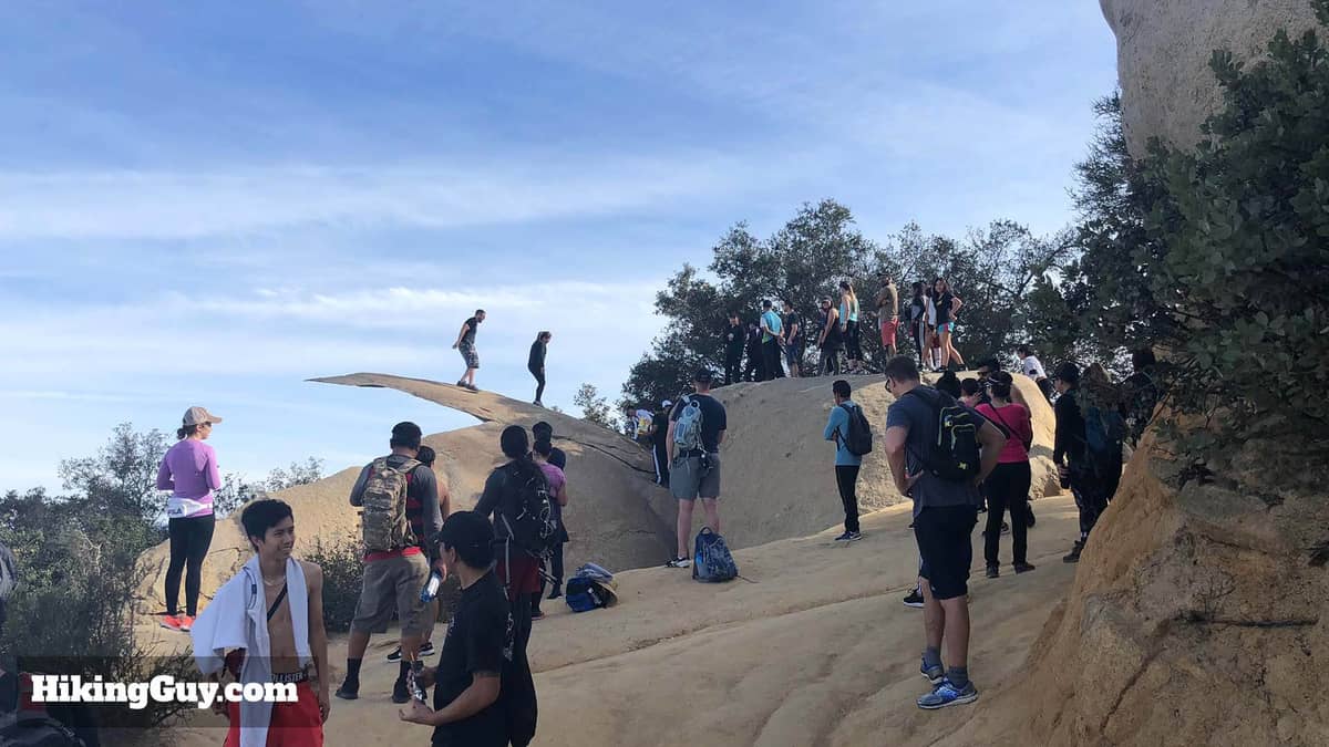
When you finally reach Potato Chip Rock, there will almost certainly be a line. On weekend mornings, the queue can stretch to 20 or 30 people, with each group taking several minutes to arrange their shot. The wait is part of the experience now — hikers chat, trade photography tips, and watch each other balance on the edge. It has a surprisingly social energy, though it is worth knowing in advance so you are not caught off guard.
The classic photo is taken from slightly below and to the side of the rock, with the subject standing on the chip with nothing but sky behind them. The drop beneath the rock is real — the exposure is genuine, not theatrical — but the ledge is stable and wide enough to stand on comfortably. Most people crouch, kneel, or strike dramatic poses. Having a friend photograph you from a specific angle makes a significant difference in the final image; the perspective only works from a particular vantage point about 10 to 15 feet below the slab.
From the broader summit area near the rock, the views extend across Poway and into the coastal valleys toward the Pacific. On clear days — especially in fall and winter after rain has scrubbed the air clean — you can make out the ocean horizon and the hills of Baja California to the south.
When to Go: Time of Day and Season
Early morning on weekdays is the single best time to visit. Arrive at the trailhead by 6:30 or 7:00 a.m. and the parking lot is manageable, the air is cool, and the line at the rock is short or nonexistent. The light at this hour is also ideal for photography — soft, directional, and warm before the sun climbs overhead.
Weekend mornings after 9:00 a.m. are a different story. The parking lot fills quickly, the trail becomes congested at the rocky sections near the summit, and the photo queue can consume 30 to 45 minutes of waiting. If a weekend visit is your only option, arriving right at the 6:00 a.m. opening gives you a meaningful head start.
Seasonally, San Diego's Mediterranean climate means the trail is hikeable year-round. Summer brings inland heat that can push temperatures well above what coastal San Diego experiences — the trailhead sits roughly 30 miles inland, and summer midday temperatures in Poway regularly exceed 90°F (32°C). Spring and fall offer the most comfortable conditions, while winter hiking is brisk but often clear. Avoid the trail during or immediately after heavy rain, when the granite slabs become slick and the dirt sections churn to mud.
💡 Local tip
For the best combination of light, crowd levels, and temperature: hike on a weekday morning in October or November. The summer marine layer that blankets coastal San Diego rarely reaches this far inland, so expect full sun and bring sun protection regardless of season.
Getting There and Practical Logistics
A personal vehicle is essentially required for this hike. The Lake Poway Recreation Area trailhead at 14644 Lake Poway Rd, Poway, CA 92064 is not served by any direct public transit route, and the surrounding roads are not walkable from transit stops. From downtown San Diego, the drive takes 35 to 45 minutes via I-15 North. There is also an alternative trailhead accessed from Highway 67 near Ramona, which some hikers use to approach from the other side, but the Lake Poway entrance is the standard and most straightforward starting point.
Parking at the Lake Poway Recreation Area is reported to cost $10 on weekends for non-Poway residents, while weekday parking has been described as free in multiple sources. These fees are subject to change; confirm current rates on the City of Poway's official recreation page before your visit. The lot has a finite number of spaces, and on busy weekend mornings it can fill by 8:00 a.m.
For broader context on getting around San Diego County by car and transit, the getting around San Diego guide covers regional transport options, including how to reach inland trailheads from the city center.
What to Bring
This is a serious half-day hike, not a quick stroll. Pack accordingly. Water is the most critical item: at least 2 liters per person, more in summer. The trail has no water sources or facilities beyond the trailhead area. Sun protection is non-negotiable — a hat, sunscreen, and UV-rated clothing matter on exposed granite ridgelines where there is no shade for long stretches.
- At least 2 liters of water per person (3+ in summer)
- Sunscreen, hat, and sunglasses
- Sturdy trail shoes or light hiking boots with grip (the granite slabs demand traction)
- Snacks or a light lunch — the round trip takes 3–5 hours
- A camera or phone fully charged before you leave the car
- A light layer for the summit, which can be noticeably cooler and windier than the valley below
Is It Worth the Effort?
That depends entirely on what you are looking for. If the goal is a challenging, rewarding hike with genuine views and a payoff at the summit, yes — Woodson Mountain delivers on those terms. The trail through chaparral and granite is genuinely attractive, and the summit views across San Diego County are expansive. The rock itself is legitimately impressive up close in a way that photographs do not fully convey.
If you are hoping for a quiet, contemplative wilderness experience, this is probably not your trail on a weekend. The social media fame has made Potato Chip Rock a pilgrimage for thousands of visitors, and the atmosphere near the summit on busy days resembles a queue at an amusement park more than a backcountry escape. That is not a reason to skip it, but it is a reason to calibrate your expectations before you commit to 8 miles.
If you are building a broader hiking itinerary, the best hikes in San Diego guide covers trails across the county that suit different fitness levels and crowd tolerances, from coastal bluff walks to serious backcountry routes.
For those who prefer their views served with less sweat, San Diego's best viewpoints include accessible overlooks from Coronado, Point Loma, and Mount Soledad that require far less elevation gain.
Insider Tips
- The photo composition only works from a specific spot about 10–15 feet below and to the side of the rock — scout the angle before your group climbs up, or ask someone already in the queue where they are shooting from.
- Weekday mornings in October and November consistently offer the shortest waits, best light, and most comfortable temperatures. If you can only visit on a weekend, arrive at the 6:00 a.m. opening to beat the main crowds by at least 90 minutes.
- The alternative Highway 67 trailhead near Ramona approaches the summit from the opposite side. It is a shorter route to the rock but involves less shade and even more exposed terrain — it is more popular with trail runners than with casual hikers.
- Cell service on the upper trail can be unreliable. Download an offline map or screenshot the trail route before leaving the parking lot, particularly if you are unfamiliar with the area.
- The granite slabs near the summit are beautiful but unforgiving — a hiking pole or two makes the descent significantly easier on your knees, especially after the adrenaline of the summit wears off.
Who Is Potato Chip Rock For?
- Active travelers who want a half-day hike with a defined destination and panoramic payoff
- Photography enthusiasts chasing a genuinely dramatic and unique natural feature
- Visitors who want to experience San Diego's inland chaparral landscape beyond the coast
- Hikers with moderate to strong fitness who are comfortable with rocky, exposed terrain
- Groups of friends or couples looking for a shared challenge and a memorable photo
Nearby Attractions
Combine your visit with:
- Anza-Borrego Desert State Park
Anza-Borrego Desert State Park stretches across more than 600,000 acres of Colorado Desert in eastern San Diego County, making it one of the largest state parks in the United States. From spring wildflower carpets to ancient slot canyons and some of the darkest skies in Southern California, it rewards visitors who plan carefully and respect the terrain.
- Border Field State Park
Border Field State Park occupies the southwestern corner of the continental United States, where Pacific surf meets the U.S.–Mexico border fence. It offers coastal wetlands, a historic marble boundary monument, and views toward Friendship Park — the U.S.-side gathering space has been closed since 2020, so confirm current access before you go.
- Cedar Creek Falls
Cedar Creek Falls is a backcountry waterfall deep inside Cleveland National Forest, reached by a strenuous 6-mile round-trip hike from Ramona. A mandatory day-use permit keeps crowds manageable, but you'll earn every step of the descent into this rugged gorge. This guide covers the permit process, trail conditions, safety warnings, and what to realistically expect.
- Chicano Park
Chicano Park is a National Historic Landmark tucked beneath the San Diego–Coronado Bridge in Barrio Logan, where more than 80 monumental murals cover the concrete pillars of a freeway overpass. Free to enter and open daily, it is one of the most culturally layered outdoor spaces in the American Southwest.