Parque Nacional Enrique Olaya Herrera: Bogotá's Historic Green Heart
Inaugurated in 1934 and declared a national monument, Parque Nacional Enrique Olaya Herrera is Bogotá's most historically significant urban park. Free to enter and open daily, it blends century-old landscape design with access to the Eastern Hills, making it a genuine refuge for locals and a rewarding detour for travelers.
Quick Facts
- Location
- Calle 35 # 3 - 50 / Carrera 7a # 37-04, La Macarena, Bogotá, D.C.
- Getting There
- TransMilenio to Calle 39, then 7 blocks east; or Museo Nacional station, about a 15-min walk north along Carrera 7
- Time Needed
- 1–3 hours (longer if you continue onto the Eastern Hills trails)
- Cost
- Free entry, no ticket required
- Best for
- Morning joggers, families, architecture lovers, hikers connecting to the Cerros Orientales
What Is Parque Nacional Enrique Olaya Herrera?
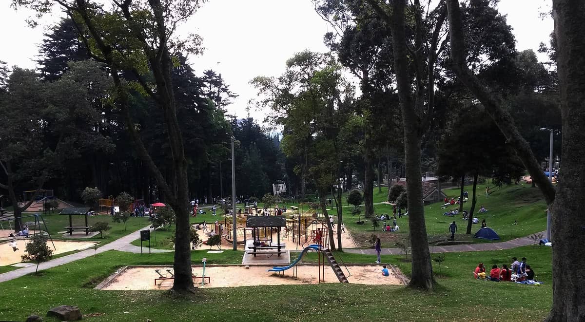
Parque Nacional Enrique Olaya Herrera is not a national park in the wilderness sense — it is a large, formally designed urban park in central Bogotá, sitting on the lower slopes of the Eastern Hills (Cerros Orientales). The name can confuse first-time visitors who expect something like a nature reserve. What you actually get is a sprawling green space with mature trees, open meadows, sports courts, walking paths, and a direct connection to the foothill trails above the city.
Conceived under Law 50 of 1931 and inaugurated on 6 August 1934 during the presidency of Enrique Olaya Herrera — for whom it is named — the park was recognized as a national monument by Decree 1756 in 1996. More than ninety years after its opening, it remains one of the most genuinely used parks in the city: not just a tourist backdrop, but a place where people actually live their daily lives.
ℹ️ Good to know
Opening hours: daily 06:00–18:00. Entry is free. No ticket, no registration required.
The Experience at Different Times of Day
The park reads very differently depending on when you arrive. At 6:30 in the morning on a weekday, the dominant sounds are birdsong from the tree canopy above the upper paths, the rhythmic slap of running shoes on paved tracks, and the occasional bark of a dog being walked by a Bogotá resident on their morning routine. The air at this hour is noticeably cool — temperatures in this part of the city regularly sit in the low to mid-teens Celsius in the early morning — and a thin mist sometimes lingers at the park's upper edges near the hillside.
By mid-morning on a weekend, the character shifts. Families spread out across the grass sections, vendors set up carts near the main entrances, and the sports courts fill with informal football and basketball games. The central open areas become the domain of children, and the quieter upper paths attract couples and solo walkers looking for a view toward the city below. Midday on Saturday is the park at its most social and its most crowded — if quiet contemplation is what you are after, this is the wrong time.
Late afternoon, roughly 4:00–5:30 p.m., is arguably the most atmospheric window. Light hits the tree canopy at a low angle, the temperature drops perceptibly, and the crowd thins to joggers finishing their circuits and dog walkers. The hillside behind the park turns a deeper green as the light fades, and from the upper paths you get a sense of the city's scale laid out to the west. Plan to be out before 6:00 p.m., as the park closes at 18:00 and the surrounding streets become quieter after dark.
⚠️ What to skip
Avoid visiting after closing time. The park's open edges and limited lighting make lingering past dusk inadvisable. Check current safety guidance for the surrounding area before visiting at off-peak hours.
Tickets & tours
Hand-picked options from our booking partner. Prices are indicative; availability and final rates are confirmed when you complete your booking.
Candelaria walking tour
From 35 €Instant confirmationFree cancellationCoffee farm guided tour
From 114 €Instant confirmationFree cancellationZipaquira Salt Cathedral guided tour
From 86 €Instant confirmationFree cancellationBogota full-day bike rental
From 19 €Instant confirmationFree cancellation
Historical and Architectural Context
The park's design reflects the ideals of early 20th-century civic planning in Latin America: a formal green space intended to bring hygiene, leisure, and civic identity to a rapidly growing capital. The layout incorporates broad pedestrian promenades, planted tree lines, and open sports areas that were progressive for their era. Over nine decades, the landscape has matured considerably — the trees that were saplings in 1934 are now large enough to form a genuine canopy in the upper sections of the park.
The park's designation as a national monument means that major structural alterations are restricted, which has helped preserve its original character. You will notice older paved paths alongside newer concrete sections, and the boundary between formal park design and the informal hillside above is deliberately blurred — the Eastern Hills simply begin where the planted sections end. This gradient from urban park to semi-wild hillside is one of the park's most distinctive features.
For context on the wider La Macarena neighborhood that surrounds the park, and how the park fits into the area's mix of arts, restaurants, and foothill access, see the La Macarena neighborhood guide.
Practical Walkthrough: How to Navigate the Park
The main address most maps reference is Carrera 7a #37-04, placing the primary entrance on the eastern side of the park, facing the hillside. An alternate official address — Calle 35 #3-50 — is used by some city sources and corresponds to a different access point. If you are navigating with a map app, check which entrance puts you at the section you want: the upper eastern edge gives quickest access to the trail connections, while the western perimeter is more convenient for sports facilities and the main open meadows.
The terrain slopes noticeably from west to east, climbing toward the Cerros Orientales. Paths include both paved promenades suitable for strollers and light footwear, and unpaved dirt sections on the upper hillside edges that require proper walking shoes. If you plan to continue beyond the park boundary onto the Cerros Orientales trails, bring layers — temperature and wind exposure increase significantly as you gain elevation — along with water and sun protection.
The park functions as one of several access corridors to Bogotá's Eastern Hills. For a fuller picture of what those trails involve, including conditions and access points, see the guide to Cerro de Monserrate, which sits further along the same ridgeline.
💡 Local tip
Wear layered clothing. Bogotá's altitude means temperatures can shift by 8–10°C between early morning and midday. A light jacket in a daypack is more useful here than almost anywhere at sea level.
Getting There
By TransMilenio, a practical approach is to ride to the Calle 39 station on the Avenida Caracas corridor, then walk approximately seven blocks east along Calle 39 toward Carrera 7. The walk takes roughly 10–12 minutes at a comfortable pace and passes through the residential-commercial mix typical of this part of the city. Alternatively, alight at the Museo Nacional station and walk north along Carrera 7 for about 15 minutes — this route is flat and passes by the Museo Nacional de Colombia if you want to combine both in one outing.
Ride-hailing apps — Uber, Cabify, and Didi — all operate in Bogotá and offer a faster option if you are coming from further afield. For a broader overview of navigating the city's transport options, the getting around Bogotá guide covers TransMilenio, taxis, and app-based rides in detail.
Photography and Sensory Notes
The park offers several photographic angles that do not show up on most travel blogs. The upper paths, especially in morning light, frame the city's skyline through a foreground of eucalyptus and oak. The older, paved promenades have a worn, dignified quality that photographs well in overcast light — and Bogotá's sky is overcast more often than not, so do not wait for sunshine to shoot here. Early morning also gives you the softest mist conditions and the lowest foot traffic.
Sensory details worth noting: the smell of damp earth and eucalyptus that rises from the upper hillside after light rain, the sound of cumbia or vallenato occasionally drifting from a portable speaker at the weekend picnic sections, and the distinctive coolness of the air at this elevation even on days when the sun is fully out. The park does not smell like a city park at ground level — the altitude and the hillside vegetation give it a distinctly cleaner quality than most urban green spaces.
If Bogotá's outdoor and green-space culture interests you, the Bogotá Ciclovía guide covers the city's extraordinary weekly cycling and walking event, which often draws participants past the park's western edge.
Who Should Skip This Park
Travelers with very limited time in Bogotá who are prioritizing museums, colonial architecture, or gastronomic experiences may find the park a lower priority than other attractions in the city. It is a park — genuinely lovely and historically significant, but without a specific feature like an art collection, a dramatic viewpoint, or a unique cultural event to anchor the visit. Visitors with significant mobility limitations should also note that the upper sections of the park involve uneven terrain that may not be comfortable to navigate.
Families with young children who need specific playground infrastructure may find the park less equipped than they expect from a major urban green space in a large capital. The open meadows work well for informal play, but dedicated playground structures are limited.
Insider Tips
- The park's upper eastern edge, closest to the hillside, is significantly quieter than the main open sections even on busy weekend afternoons. Follow the path uphill and you will quickly leave the crowds behind.
- If you are visiting on a Sunday, check whether Ciclovía is active — Avenida Carrera 7 transforms into a car-free cycling and walking corridor, and the walk to the park becomes a pleasure rather than a dodge through traffic.
- Bogotá's rainy seasons (April–May and September–November) can make the unpaved upper paths muddy and slippery. If you plan to walk toward the hillside trails, solid closed-toe shoes are worth the fuss.
- The park is a national monument, which means street vendors and permanent commercial structures inside are restricted in some areas. Bring your own water and snacks if you prefer not to rely on on-site options.
- For the clearest views toward the city from the upper paths, arrive between 9:00 and 11:00 a.m. By early afternoon, cloud cover often reduces visibility.
Who Is Parque Nacional Enrique Olaya Herrera For?
- Morning joggers and cyclists looking for a traffic-free route with elevation gain
- Travelers who want to access the Eastern Hills trails without committing to a full Monserrate ascent
- Families wanting open green space in a central, easily accessible location
- History and architecture enthusiasts interested in early 20th-century Colombian civic design
- Anyone spending time in La Macarena who wants a low-key, no-cost outdoor break between meals or gallery visits
Nearby Attractions
Other things to see while in La Macarena:
- Museo Nacional de Colombia
The Museo Nacional de Colombia tells the full arc of the country's story, from pre-Columbian civilizations through independence to the present day. Housed in the striking former Panóptico de Cundinamarca, the building itself is as compelling as the collection inside. It sits in the Centro Internacional area on Carrera 7 between Calles 28 and 29, and offers free entry on Wednesday afternoons and the last Sunday of every month.