Horseshoe Bend: The Colorado River Overlook Worth the Drive from Las Vegas
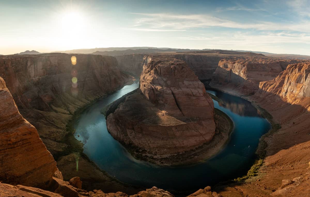
Horseshoe Bend is the dramatic 270-degree curve of the Colorado River carved into red Navajo sandstone near Page, Arizona. A 0.6-mile trail leads to one of the most photographed geological formations in the American Southwest, sitting roughly 4.5 hours' drive from Las Vegas to the Page, AZ area.
Quick Facts
- Location
- US-89, Mile Marker 545, 5 miles south of Page, AZ 86040 (Glen Canyon National Recreation Area)
- Getting There
- No public transit; drive via I-15 North and connecting highways to US-89 from Las Vegas (~4.5–5 hours each way).
- Time Needed
- 1.5–2 hours at the site; plan a full day from Las Vegas including drive time
- Cost
- No admission fee; parking $10 per passenger vehicle, $5 per motorcycle
- Best for
- Landscape photography, day-trippers from Las Vegas, nature lovers, Southwest road trips
- Official website
- horseshoebend.com
What Horseshoe Bend Actually Is
Horseshoe Bend is a meander of the Colorado River so exaggerated it looks almost engineered. The river curves nearly 270 degrees around a sandstone fin before reversing direction, cutting roughly 1,000 feet below the rim where visitors stand. The overlook sits within the Glen Canyon National Recreation Area, managed by the National Park Service, just 5 miles south of the small city of Page in northern Arizona.
The formation is entirely natural, the product of millions of years of river incision into Navajo sandstone. The rock walls are a warm amber-red, contrasting with the green-blue Colorado River below. On clear days, the color contrast between stone and water is striking enough that photos from this spot routinely go viral. But no photograph fully communicates the scale. Standing at the unguarded edge and looking straight down is a different experience from anything a screen can prepare you for.
⚠️ What to skip
There are no railings at the overlook. The drop is approximately 1,000 feet. Keep children close, watch your footing near the rim, and treat the edge with serious respect.
The Drive from Las Vegas: What to Expect
Horseshoe Bend sits approximately 270 miles from Las Vegas, with typical drive times around 4 to 4.5 hours each way via I-15 North through the Virgin River Gorge, then US-89 toward Page. This is not the Hoover Dam corridor. Most of the drive is straightforward highway travel, but the final stretch on US-89 through the Navajo Nation is particularly scenic.
If you are considering this as a day trip from Las Vegas, be realistic about the commitment: a round trip is roughly 9 hours of driving. Many visitors combine it with a stop at Antelope Canyon, which is within a few miles of Page and can be toured in the same day. Others treat it as an overnight trip, staying in Page and catching sunrise or sunset at the rim before the parking lot fills.
For a broader picture of how Horseshoe Bend fits into the region, the day trips from Las Vegas guide covers logistics, route options, and how to structure a multi-stop itinerary across the Colorado Plateau.
Tickets & tours
Hand-picked options from our booking partner. Prices are indicative; availability and final rates are confirmed when you complete your booking.
Antelope Canyon and Horseshoe Bend tour from Las Vegas
From 198 €Instant confirmationFree cancellationAntelope Canyon X and Horseshoe Bend Tour from Las Vegas
From 161 €Instant confirmationFree cancellationUpper Antelope Canyon and Horseshoe Bend Tour from Las Vegas
From 210 €Instant confirmationFree cancellationLower Antelope Canyon and Horseshoe Bend tour from Las Vegas
From 217 €Instant confirmationFree cancellation
The Trail: What You Walk and What You See
The trail from the parking lot to the overlook is about 0.7 miles one way, gaining minimal elevation for most of its length before a short rise over a sandstone ridge near the end. The surface is hard-packed sand and gravel on most of the route, with a designated accessible packed path leading to a fenced viewing platform; the original sandy branch to the main overlook can still challenge manual wheelchairs without assistance.
The walk itself offers virtually no shade. From late spring through early fall, the trail reflects heat from the surrounding rock and soil, and surface temperatures can climb well above air temperature. You will feel this in your first few minutes, especially on the return uphill section after the ridge. Carrying at least one liter of water per person is not optional during warm months. The site has no water sources or fountains at the trailhead.
At the rim, you have two main vantage points: a central lookout directly above the bend's apex, and a narrower secondary point slightly to the right that gives a different angle on the river below. The central point is where the crowd concentrates. If you walk a few minutes along the rim in either direction, the crowds thin considerably and you get framing options that most visitors miss entirely.
💡 Local tip
Photography tip: A wide-angle lens (16–24mm on full frame) is ideal for capturing the full sweep of the bend. Check current regulations before attempting any drone use, as recreational flying is generally prohibited and special authorization is required for permitted operations.
Best Time to Visit: Light, Crowds, and Weather
Sunrise and the hour or two after it produce the most dramatic light at Horseshoe Bend. The eastern canyon walls catch the first warm light while the river below remains partially shadowed, creating depth and contrast. By mid-morning the entire scene is in full sun, which can wash out colors and creates harsh shadows in photographs. Late afternoon, particularly in the hour before sunset, offers similarly warm tones from the opposite direction.
Crowds arrive in force by 9 or 10 in the morning and remain heavy through early afternoon on weekends and during summer months. In peak season, the parking lot fills and vehicles queue along the highway shoulder. Arriving before 7:30 AM gives you both the best light and a quieter experience at the rim. Weekdays in shoulder season, particularly March, April, October, and November, offer a more relaxed visit with shorter parking waits.
Summer heat is a genuine concern. Page, Arizona, regularly sees temperatures above 100°F from June through August. The exposed trail and shadeless rim amplify this. Winter visits are entirely possible and the crowds thin significantly. Snow occasionally dusts the rim, which creates unusual and striking photographs. Cold mornings can also produce fog in the canyon below, another rarely-seen effect worth planning around if weather permits.
ℹ️ Good to know
The parking lot and trail are open sunrise to sunset, every day of the year, including holidays. Parking is $10 per passenger vehicle and $5 per motorcycle. No entrance fee is charged for the overlook or trail itself.
Practical Details: Parking, Fees, and Gear
The dedicated parking lot off US-89 between Mile Markers 545 and 544 on City of Page land is the only legal parking option for the site. Payment is collected at the lot. The fee is $10 per passenger vehicle and $5 per motorcycle, with commercial vehicle rates also posted. There is no annual pass that waives this specific fee, as it is managed separately from the standard NPS America the Beautiful pass structure. Confirm current fee details at the lot or on the official website before your visit.
Basic restroom facilities are available at the trailhead parking area. There are no food vendors, no water stations, and no shade structures at any point along the trail or at the rim. What you bring is what you have. Sunscreen, a hat with a brim, and more water than you think you need are the practical non-negotiables for any visit between April and October. Closed-toe shoes with grip help on the sandy sections near the rim edge.
Is It Worth the Drive? An Honest Assessment
The honest answer is that Horseshoe Bend rewards visitors who approach it with the right expectations. The overlook itself is genuinely spectacular, one of the more vertiginous and visually complete natural scenes in the American Southwest. The scale at the rim is something photographs cannot replicate, and first-time visitors consistently describe a sense of physical surprise at how far down the river actually is.
That said, the 4.5-hour drive each way makes this a significant commitment from Las Vegas. Visitors who also plan to tour Antelope Canyon, explore Valley of Fire State Park en route, or continue into southern Utah will get considerably more value from the journey than those making a dedicated round trip. If the Colorado River canyon landscape is what draws you, consider also looking at Lake Mead National Recreation Area, which is far closer to Las Vegas and offers a different perspective on the same river system.
Who might want to skip it: travelers with mobility limitations who need fully paved surfaces, visitors during peak summer heat who are not prepared for full sun exposure, and anyone hoping for a quick, low-effort stop. The site demands a committed half-day minimum just for the drive logistics, and the exposed trail in midday heat can be genuinely unpleasant for those unprepared.
Context: Geology and the Colorado River
Horseshoe Bend formed when the ancestral Colorado River established its course across a relatively flat plateau surface, cutting sinuous meanders as rivers naturally do. As the Colorado Plateau gradually uplifted over millions of years, the river's downward cutting accelerated while the meander shape was preserved. The result is an entrenched meander, the serpentine path now locked hundreds of feet below the rim rather than freely migrating across flat ground.
The rock exposed at the overlook is Navajo sandstone, a formation deposited roughly 190 million years ago from vast Jurassic-era sand dunes. Its characteristic warm orange-red tones come from iron oxide in the grain cement. The blue-green color of the Colorado River below is a function of light reflection, sediment load, and water depth, and shifts noticeably with time of day and season.
Insider Tips
- Walk the rim at least 100 meters in each direction from the main overlook. The secondary angles are less crowded and show different perspectives of the bend that the central viewpoint cannot offer.
- The parking lot gate opens at sunrise. Arriving 15 to 20 minutes before sunrise means you walk in near-dark but reach the rim just as the canyon walls catch the first light. Bring a flashlight or use your phone torch on the trail.
- Antelope Canyon tours depart from Page, which is 5 miles north of the trailhead. Book your Antelope Canyon slot in advance for the same morning (early slot), then walk Horseshoe Bend afterward to avoid the midday heat.
- The return walk back over the sandy ridge can feel harder than the approach, especially in heat. Pace yourself and drink water before you feel thirsty. Heat exhaustion is a documented risk here in summer months.
- Winter weekday mornings offer the thinnest crowds of any time of year. If snow has fallen recently, the red-and-white rim against the green river is a genuinely unusual sight that most visitors never see.
Who Is Horseshoe Bend For?
- Photographers seeking Southwest landscape shots at golden hour
- Road-trippers building a Colorado Plateau itinerary from Las Vegas
- Visitors pairing with an Antelope Canyon tour for a full day near Page
- Geology and natural history enthusiasts
- Travelers who want a dramatic nature payoff without technical hiking
Nearby Attractions
Combine your visit with:
- Antelope Canyon
Antelope Canyon is a series of sculpted slot canyons carved into Navajo Sandstone near Page, Arizona, and one of the most visually striking natural formations in the American Southwest. Accessible only on guided tours led by licensed Navajo guides, it requires advance planning but rewards visitors with an experience unlike anywhere else within day-trip range of Las Vegas.
- Area 51 & Extraterrestrial Highway
Nevada State Route 375, officially designated the Extraterrestrial Highway in 1996, is a 98-mile desert drive skirting the perimeter of the most famous restricted military installation on Earth. It costs nothing to drive, demands serious preparation, and delivers a genuinely remote American landscape that few Strip visitors ever see.
- AREA15 Immersive Entertainment Complex
AREA15 is a 35-acre immersive entertainment and events district just off the Las Vegas Strip, packed with art installations, bizarre interactive experiences, bars, and ticketed attractions like Omega Mart. Daytime entry is free, but the real substance costs extra — and it's worth understanding the pass tiers before you arrive.
- Death Valley National Park
Just two hours from the Las Vegas Strip, Death Valley National Park is the hottest, driest, and lowest national park in the United States. From the salt flats of Badwater Basin to the sculpted dunes of Mesquite Flat, it rewards early risers and well-prepared visitors with landscapes found nowhere else on Earth.