Black Rock Viewpoint (Pa Hin Dam): Phuket's Best Panorama You'll Actually Work For
Perched at roughly 290 meters above southern Phuket, Black Rock Viewpoint — known in Thai as Pa Hin Dam, or 'Black Rock Cliff' — delivers a sweeping panorama over Nai Harn Beach, Nui Beach, and the open Andaman Sea. It's free, it's rarely crowded, and getting there requires a genuine effort through jungle trails or steep dirt roads. That effort is precisely what keeps it worth making.
Quick Facts
- Location
- Soi Laem Mum Nok, Karon, Muang, Phuket — southern peninsula near Karon Viewpoint
- Getting There
- No public transit. Hire a motorbike, use Grab, or hike 6 km from Nai Harn Beach
- Time Needed
- 1.5–3 hours depending on route; allow more for photography at the top
- Cost
- Free entry
- Best for
- Hikers, photographers, sunset seekers, and anyone escaping the crowd at Karon Viewpoint
What Black Rock Viewpoint Actually Is
Pa Hin Dam — literally 'Black Rock Cliff' in Thai — is a natural rock outcrop on Phuket's southern peninsula, sitting at approximately 290 to 300 meters elevation. The name refers to the exposed slabs of flat black granite that form the viewpoint itself: dark, weathered stone polished smooth enough to sit on, jutting out over a drop with nothing between you and the coastline below.
Until around 2016, this spot was essentially unknown outside of local trail runners and the occasional adventurous expat. It has since grown a quiet following, but it still sees a fraction of the foot traffic at nearby Karon Viewpoint, which sits on a paved road just a short distance away. That contrast is stark: Karon draws tour vans and selfie crowds; Pa Hin Dam draws people who deliberately sought it out.
The viewpoint looks north over Nai Harn Beach and directly down toward Nui Beach, with unobstructed sightlines across the Andaman Sea toward the outer islands on clear days. The perspective is genuinely different from Karon Viewpoint — lower in the treeline, closer to the cliff edge, and framed by jungle canopy on three sides.
💡 Local tip
Bring at least one liter of water per person regardless of route length. The trails are shaded, but the humidity and steep sections make dehydration faster than you'd expect.
How to Get There: Your Three Options
There is no public transport to Pa Hin Dam. Getting there means either riding a motorbike up a steep dirt road, hiking from the coast, or arriving by Grab and walking the final stretch.
Option 1: From Karon Viewpoint (Easiest by Motorbike)
The most direct approach starts near Karon Viewpoint. From the main viewpoint car park, take the dirt road heading right (when facing the sea) for a few hundred meters until you spot a large rock marked 'Pa Hin Dam' with a Thai-language sign. From there, a short, steep walk of 5 to 10 minutes through light scrub brings you to the granite slabs. The dirt road is rideable on a motorbike with decent tires, but it is steep and loose in sections — take it slowly and park before the final approach on foot.
Option 2: The 6 km Loop from Nai Harn Beach
For a proper half-day hike, park at Nai Harn Beach and follow the trail through the grounds beside the Nai Harn Hotel, then pick up the shaded jungle path heading uphill. The full loop covers roughly 6 kilometers with significant elevation gain. The trail is well-shaded, which reduces heat stress, but the surface is uneven and can be muddy after rain. Good trail shoes or at minimum solid sandals with grip are required — flip-flops will cause problems.
Option 3: The 1 km Trail from Nui Beach
A shorter jungle trail begins from the Nui Beach parking area. At around 1 kilometer, it is compact but consistently steep. This works well if you combine a morning swim at Nui Beach with the hike up — arrive early, swim before the heat builds, then ascend. The trail is narrow and not signposted in English, so a screenshot of an offline map is useful before you lose signal.
⚠️ What to skip
The dirt road and jungle trails are NOT suitable for wheelchair users or anyone with limited mobility. There are no handrails, no paved surfaces, and multiple sections require using hands for balance on steeper rocks.
Tickets & tours
Hand-picked options from our booking partner. Prices are indicative; availability and final rates are confirmed when you complete your booking.
Muay Thai Boxing Tickets at Patong Boxing Stadium
From 56 €Instant confirmationFree cancellationPhuket Island and Big Buddha Private Tour
From 125 €Instant confirmationFree cancellationGuided elephant nature walk tour with transfer
From 50 €Instant confirmationFree cancellationFull-day tour to the highlights of Phuket City and its surroundings
From 71 €Instant confirmationFree cancellation
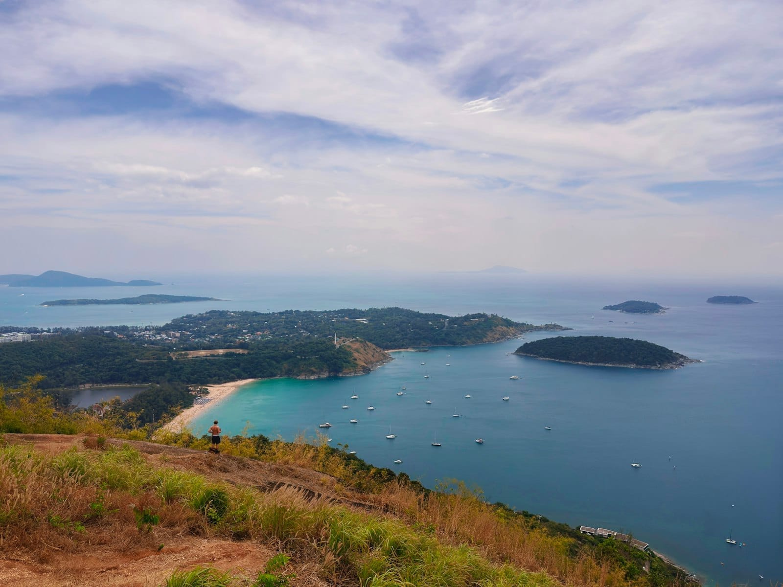
What You See at the Top
The flat black granite slabs open up suddenly after the final push through the treeline. There is no fence, no railing, and no viewing platform: just open rock and open sky. The surface is large enough for a small group to spread out comfortably, which means you are not jostling for position the way you would be at a formal viewpoint.
Looking north, Nai Harn Beach curves in a clean arc below, its sand pale against the turquoise water. On clear days the outer Andaman islands are visible as dark silhouettes. Directly below the cliff face, Nui Beach is small and sharp — a reminder of how quickly the terrain drops. To the south, the coastline continues toward Ya Nui Beach and Promthep Cape, both visible on days without haze.
The granite surface itself is worth noticing. The rock is dark grey to near-black, with a coarse texture that provides grip even when slightly damp. Small fissures run through the slabs, and patches of lichen and scrub cling to the edges. It does not look curated or maintained — because it is not. This is an undeveloped natural site, and that rawness is part of what makes it distinct.
Best Time to Visit and How the Experience Changes by Hour
Sunset is the headline draw, and with good reason. In the hour before the sun drops into the Andaman Sea, the light turns the granite from dark grey to amber and the sea below shifts through a sequence of copper and rose tones. The western-facing exposure means you get a direct view of the sun descending, with no obstructions from the treeline once you are out on the rocks.
However, arriving at sunset means navigating back down the trail in the dark, which is genuinely unpleasant without a torch. If you are hiking rather than riding a motorbike, either bring a reliable headlamp or plan to leave the summit 20 to 30 minutes before the sun fully sets to descend with remaining light.
Early morning offers a different quality entirely. Before 8 am, the jungle is cool, the trail is empty, and the light from the east catches the sea surface below in a bright silver glare. There is no guarantee of a dramatic sky, but the solitude is consistent. Late morning and midday are the least rewarding: heat builds quickly on exposed rock with no shade, and any haze tends to peak by noon, softening the views.
ℹ️ Good to know
Dry season (November to April) gives the clearest visibility and safest trail conditions. During the rainy season (May to October), trails become slippery and muddy, and the viewpoint is frequently obscured by cloud. If you visit in the wet season, aim for early morning before afternoon storms build.
Photography at Pa Hin Dam
The rock slabs give photographers a stable platform with multiple foreground options: the texture of the granite itself, the scrub at the cliff edge, or the raw drop to the coast below. A wide-angle lens captures the full sweep from Nai Harn around to the southern cape. Telephoto compression, by contrast, pulls the outer islands closer and creates a stacked-horizon effect with the sea layers.
The lack of fencing means you can get very close to the edge for low-angle shots. Exercise genuine caution here: the cliff drops sharply and the surface can be slick after recent rain. Do not prioritize a shot over your footing. Tripods are practical given the flat surface and are useful for the low-light window around sunset.
Context: Where This Fits in the Southern Phuket Landscape
Pa Hin Dam sits within the cluster of attractions that make southern Phuket worth a full day of exploration. Karon Viewpoint is the obvious neighbour — if you are already there, the additional effort to reach Pa Hin Dam is minimal by motorbike and significant but rewarding on foot. The two viewpoints serve different purposes: Karon for a quick, accessible overview; Pa Hin Dam for an immersive, isolated experience.
Below the hill, Nai Harn Beach is one of Phuket's more relaxed southern beaches, suitable for a swim before or after the hike. Promthep Cape is a short drive further south and pairs naturally with a Pa Hin Dam sunset visit if you split your time between the two — the cape for the crowd and the social experience, Pa Hin Dam for the quiet version of the same light.
For travelers basing themselves in this part of the island, the Rawai and Chalong area gives easy access to the southern viewpoints, Chalong Bay, and a network of local restaurants that serve a primarily resident rather than resort crowd.
Who Should Skip This
Pa Hin Dam is not the right stop for everyone. If you are traveling with young children, elderly family members, or anyone who cannot manage uneven terrain and steep gradients, Karon Viewpoint immediately nearby gives a comparable coastal view from a paved, fenced platform with no hiking required.
Travelers with tight schedules who have already seen the Karon Viewpoint panorama may not find the additional effort proportionate to the marginal difference in perspective. And if you arrive expecting a polished, Instagram-optimised destination with facilities, you will be disappointed: there are no toilets, no vendors, no shade structures, and no signage in English beyond the initial trail marker.
In short: this rewards curiosity and physical effort. It does not reward passive tourism.
Insider Tips
- Screenshot an offline map before you leave phone signal range — the trail from Nui Beach is not signposted in English and forks once near the top.
- If you ride a motorbike up the dirt road from the Karon Viewpoint side, park before the final rocky section and walk the last 5 minutes. Riding all the way to the edge is possible but not worth the risk on loose terrain.
- Visit on a weekday if possible. Weekends bring more Thai day-trippers, particularly in the late afternoon, which is the only time the summit feels even slightly crowded.
- Combine the hike with a stop at Nui Beach for a swim before you ascend — the water there is clear, calm, and far less frequented than Nai Harn. You will appreciate the cool-down before climbing.
- Bring a headlamp if you are staying for sunset. The trail back through the jungle is genuinely dark by 7 pm, and your phone torch will drain your battery faster than you want.
Who Is Black Rock Viewpoint For?
- Hikers and trail walkers looking for a route with a dramatic payoff at the end
- Photographers wanting an unobstructed, non-commercialized sunset platform
- Travelers who have already done Karon Viewpoint and want a less crowded alternative
- Motorbike riders doing a southern Phuket loop who want an off-paved-road detour
- Anyone willing to trade 30 minutes of effort for a panorama that most day-trippers never find
Nearby Attractions
Other things to see while in Rawai & Chalong:
- Chalong Bay
Chalong Bay (Ao Chalong) is Phuket's largest and most active boat anchorage, serving as the main departure point for island day trips, dive boats, and yacht charters. It's not a swimming beach, but understanding what it is makes it genuinely useful for any southern Phuket itinerary.
- Coral Island (Koh Hae)
Koh Hae, known to most visitors as Coral Island, is a small island roughly 3 km southeast of Phuket, reachable by speedboat in under 20 minutes from Chalong Pier or Rawai Beach. It offers two sandy beaches, accessible snorkeling over coral reefs, and a range of watersports — without the full-day commitment of Phi Phi or Racha Island.
- Nai Harn Beach
Tucked into Phuket's southern tip, Nai Harn Beach offers a rare combination of clear water, genuine calm, and striking natural scenery. At roughly 700 meters long, it stays manageable even in peak season, drawing a mix of long-term expats, families, and travelers who've learned that louder doesn't mean better.
- Promthep Cape
Laem Promthep sits at the absolute southern tip of Phuket Island, where limestone cliffs drop into the Andaman Sea and the horizon stretches unbroken at dusk. Free to enter and open around the clock, it's the island's most iconic spot to watch the sun disappear — if you time it right and manage the crowds.