Bitou Cape Trail: Cliffs, Capes, and Open Pacific Sky
The Bitou Cape Trail (鼻頭角步道) traces a narrow coastal ridge above the Pacific Ocean in Ruifang District, New Taipei City. Free to enter and roughly 3.5 km long, it rewards hikers with some of the most dramatic ocean scenery within striking distance of Taipei. Note that sections have been under reconstruction since 2020, so checking current trail status before visiting is essential.
Quick Facts
- Location
- Bitou Road, Ruifang District, New Taipei City 224, Taiwan
- Getting There
- TRA train to Ruifang Station, then bus 856 (Gold Fulong line) or 791 to Bitoujiao bus stop
- Time Needed
- 2 to 3 hours for the trail; half a day including travel from Taipei
- Cost
- Free (no admission fee)
- Best for
- Coastal hiking, photography, and half-day escapes from the city
- Official website
- www.necoast-nsa.gov.tw/Attraction-Content.aspx?a=183&l=2
What Is the Bitou Cape Trail?
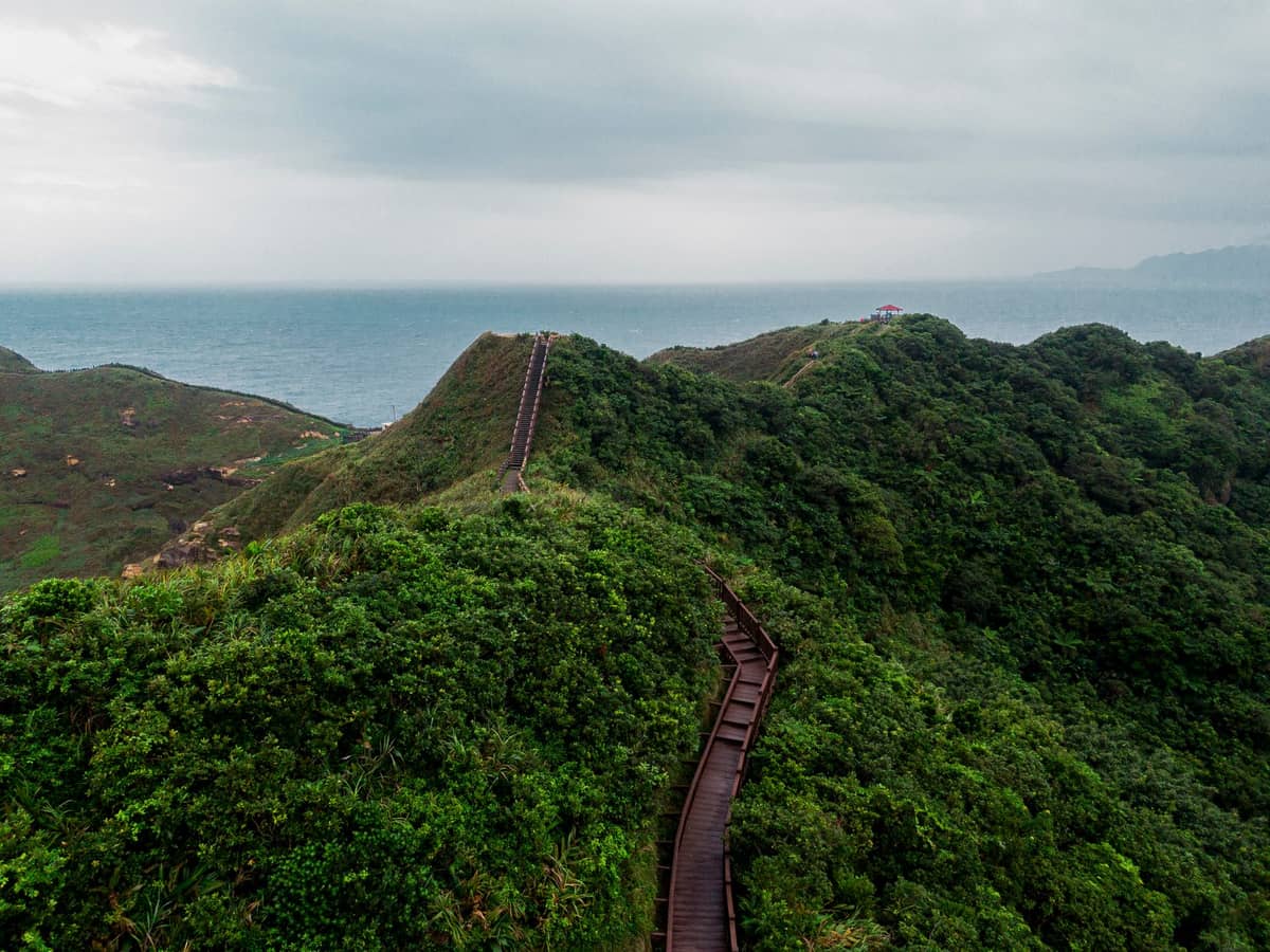
The Bitou Cape Hiking Trail (鼻頭角步道) sits at a rocky promontory on Taiwan's northeast coast, where the Pacific Ocean pushes in hard against sheer sedimentary cliffs. Administered by the Northeast and Yilan Coast National Scenic Area, the trail runs approximately 3.5 km and combines coastal ridge walking with forested inland sections, punctuated at intervals by open viewpoints that look out across deep-blue ocean and the scalloped bays of the northeast coast.
This is not a groomed urban park path. The route involves stone staircases, uneven packed-earth sections, and narrow ridge segments where the drop to the water is close enough to notice. For anyone who finds Taiwan's big-city hiking trails too mild, Bitou Cape delivers genuine coastal exposure without requiring specialist equipment or exceptional fitness.
⚠️ What to skip
Trail closures: A significant portion of the Bitou Cape Trail has been officially closed or under reconstruction since around 2020. On-site signage may redirect you to a shorter accessible loop. Check current conditions locally before making the trip, and do not attempt to pass closure barriers.
The Landscape: What You Actually See Here
The cape itself is a wedge of folded sandstone and shale that juts into the Pacific, its layered rock face cut into honeycombed formations by salt spray and erosion. From the higher ridge sections, the coastline curves away in both directions, with the deep green hills above Jiufen visible to the southwest and the open ocean stretching to the horizon to the east. On clear days, the water shifts through multiple shades of blue and green depending on depth.
The lower sections of the trail pass through dense subtropical vegetation: ferns, coastal grasses, and low-canopy trees that block the wind and create a noticeably different microclimate from the exposed ridge above. The transition from forest shade to open cliff-top happens quickly, which makes the viewpoints feel earned rather than handed to you.
Wildlife along the route is worth paying attention to. Shore birds work the cliff edges, and the tide pools visible from above hold the kind of marine life common to Taiwan's northeast coast. You are unlikely to see much at trail pace, but pausing at the lower viewing platforms gives time for the full coastal picture to settle.
Morning vs. Afternoon: How the Experience Changes
Morning visits have a clear practical advantage: the northeast coast's predictable sea breeze hasn't built to full strength yet, and light mist frequently sits over the water in the early hours, softening the distant headlands into shapes that look more painted than real. By 9 a.m., the trail receives its first regular visitors from Taipei, but the total numbers rarely make the path feel crowded.
Midday can be punishing in summer. The exposed ridge sections offer no shade, and temperatures on the cape in July and August can be significantly higher than what a forecast for Taipei city will suggest. Bring more water than you think you need. The trail's forested lower sections offer some relief, but any extended time on the upper viewpoints in midsummer should be planned with the heat in mind.
Afternoon light on the Pacific-facing cliffs is exceptional for photography, particularly in autumn and winter when the sun angles lower and the water takes on a metallic quality. Late afternoon also tends to clear the trail of day-trippers who started early, leaving the viewpoints quieter just as the light improves.
💡 Local tip
Autumn (October to November) and winter (December to February) offer the most reliable clear skies on the northeast coast. Spring brings mist and fog that can be atmospheric but frequently obscures long-distance views. Summer humidity reduces visibility and adds heat stress.
Getting to Bitou Cape Trail from Taipei
The most reliable route from Taipei is by Taiwan Railways (TRA) from Taipei Main Station to Ruifang Station, a journey of roughly 45 to 50 minutes. From Ruifang, bus 856 (the Taiwan Tourist Shuttle "Gold Fulong" line) runs along the northeast coast and stops at Bitoujiao, the closest stop to the trailhead. Bus 791, which also covers the coastal route, is an alternative with slightly different scheduling.
From Keelung, bus 791 runs directly to the Bitou Cape stop along the coastal highway, making this a logical extension if you are already on the north coast. The trail also pairs well with a visit to Jiufen Old Street or a full day along the northeast coast: bus 856 connects both stops, so linking the two in sequence is straightforward without backtracking to Taipei.
There is no MRT line that runs to this part of the coast. If you are relying on Taipei MRT, your route will still require a TRA train connection at Taipei Main Station or a bus from the city.
ℹ️ Good to know
Bus 856 (Gold Fulong line) runs on a tourist shuttle schedule that varies by season. Confirm current timetables at Ruifang Station or at the Taiwan Tourist Shuttle official site before planning your return. Gaps between buses can be 30 to 60 minutes.
Practical Walkthrough: What to Expect on the Trail
The main trailhead is a short walk from the Bitoujiao bus stop. A small parking area and basic facilities mark the start. From here, the path climbs steadily through forest before opening onto the coastal ridge. The first major viewpoint comes within about 15 to 20 minutes of walking, overlooking the rocky promontory and the sea below.
Because sections have been closed for safety and reconstruction, including the route to Bitou Cape Lighthouse, the officially listed route of about 3.5 km may not be fully available to general visitors. On-site signage typically indicates which sections are passable. Many visitors complete a shortened out-and-back route to the cape viewpoints, which still delivers the essential experience. Attempting to bypass closure barriers is not advisable: the coastal terrain is steep and the consequences of an unexpected section of broken path are serious.
- Footwear: trail runners or light hiking shoes with grip. Flat-soled sandals are inadequate for the stone stairs and uneven sections.
- Water: carry at least 1 litre per person in warm months. No reliable water sources exist on the trail.
- Sun protection: hat, sunscreen, and UV-blocking clothing for any ridge sections.
- Rain: the northeast coast receives more rainfall than Taipei city. A compact rain layer is worth carrying year-round.
- Bag: hands-free is preferable on the steeper stair sections.
The trail is not wheelchair-accessible. Narrow paths, staircases, and uneven coastal terrain make it impractical for pushchairs as well. For accessible outdoor experiences near Taipei, Daan Forest Park and Taipei Botanical Garden offer easier terrain.
Context: The Northeast Coast Beyond the Trail
Bitou Cape sits within the Northeast and Yilan Coast National Scenic Area, one of Taiwan's most geologically varied coastal zones. The same administrative area covers the sea-carved formations at Yehliu Geopark to the northwest and extends south toward the Yilan coast. The folded rock strata visible at Bitou Cape are the product of tectonic collision between the Philippine Sea Plate and the Eurasian Plate, processes still active across northeast Taiwan.
The cape has been a navigational landmark for ships working the Taiwan Strait and the Pacific coast for centuries. The fishing community at the base of the headland is small and functional rather than touristified, which distinguishes Bitou from the heavier foot traffic at nearby Jiufen or Shifen. There are no significant commercial developments at the trailhead, no souvenir rows, and no queues.
For those planning a fuller day on the northeast coast, this trail works naturally as part of a day trip that also includes the old mining district around Ruifang. Our guide to north coast day trips from Taipei covers how to combine these stops efficiently.
Who Should Skip This Trail
Visitors with limited mobility or those travelling with very young children will find the terrain genuinely challenging. The stair-heavy sections and narrow cliff paths are not adaptable, and there is no alternative flat route that delivers the same views.
Anyone expecting well-signposted, groomed infrastructure comparable to Taipei's urban parks may be disappointed. The northeast coast trail network is more raw, and with ongoing reconstruction, some of the original route remains unavailable. If your priority is a complete loop trail with consistent facilities, it is worth verifying current conditions before making the 1.5-hour journey from the city.
In typhoon season (roughly June to October), the northeast coast is the first part of Taiwan to receive direct impact from Pacific storms. Even at the edge of a typhoon track, the cape can experience dangerous wind and rain. Check Central Weather Administration forecasts and avoid visiting if any warning level is in effect.
Insider Tips
- Take the first bus of the morning from Ruifang (around 8 to 9 a.m.) to reach the trailhead before the main wave of day-trippers from Taipei arrives. The viewpoints feel entirely different when you have them to yourself.
- The fishing port just below the cape has a small number of local eateries that serve simple seafood at prices aimed at residents rather than tourists. Worth a stop after the hike if anything is open, which varies by day and season.
- Binoculars add significant value here. The ocean views from the ridge are wide enough that distant islands, fishing boats, and shore birds become part of the picture rather than background detail.
- If bus 856 schedules don't align with your return time, a taxi from the trailhead to Ruifang Station is a practical fallback. Confirm fare before boarding, as this is a less-trafficked route.
- The trail is noticeably less crowded on weekdays than weekends, even in peak season. If you have flexibility, a Tuesday or Wednesday visit avoids the families and tour groups that gather at the trailhead on Saturdays and Sundays.
Who Is Bitou Cape Trail For?
- Hikers looking for coastal scenery without a full-day commitment
- Photographers chasing sea-cliff light, especially in autumn and winter afternoons
- Taipei visitors who have already done the city's main sites and want a half-day in genuinely different terrain
- Northeast coast day-trippers combining Bitou with Jiufen or Ruifang
- Travellers interested in Taiwan's geological coastline rather than its commercial attractions
Nearby Attractions
Combine your visit with:
- Houtong Cat Village
Houtong Cat Village is a retired mining settlement in New Taipei City's Ruifang District where a large resident cat population transformed a fading industrial town into one of Taiwan's most photographed day trips. The village is free to enter, reached by a scenic Taiwan Railways train ride from Taipei, and pairs well with the adjacent Houtong Coal Mine Ecological Park.
- Jinguashi Gold Museum Area
Set high in the mountains of Ruifang District, the Gold Museum in Jinguashi preserves an entire Japanese-era gold and copper mining complex. Expect underground tunnel walks, colonial architecture, a POW camp memorial, and sweeping Pacific coastline views, all within a single open-air park.
- Jiufen Old Street
Jiufen Old Street (Jishan Street) is a narrow, lantern-lit lane winding through a former gold-mining town above Taiwan's northeast coast. Free to enter and accessible by train and bus from Taipei, it rewards visitors who arrive early or stay for dusk, when the red lanterns glow against the mountain fog.
- Pingxi Old Street
Pingxi Old Street is a narrow, railway-hugging lane in New Taipei City where Taiwan's sky lantern tradition comes to life. Built on the bones of a coal mining community, this free-admission street rewards visitors with lantern shops, traditional snacks, and mountain valley scenery that feels genuinely removed from the capital.