San Francisco–Oakland Bay Bridge: The Complete Visitor Guide
The San Francisco–Oakland Bay Bridge is one of the most significant pieces of infrastructure in the American West, carrying traffic (now designated as Interstate 80) across San Francisco Bay since 1936. While it is not a walk-through attraction, the views from the Embarcadero waterfront and the eastern span's bike path make it a compelling stop for curious travelers.
Quick Facts
- Location
- Spans San Francisco Bay between San Francisco, Yerba Buena Island, and Oakland, CA
- Getting There
- F-line streetcar along Market Street and the Embarcadero; BART or Muni Metro to Embarcadero Station for western views
- Time Needed
- 30–60 minutes for waterfront viewing; 2–3 hours for the eastern span bike path
- Cost
- Free to view from shore; westbound vehicle toll applies (check current rates at bayareafastrak.org)
- Best for
- Architecture enthusiasts, photographers, cyclists, and anyone curious about Bay Area engineering history
- Official website
- http://www.baybridgeinfo.org
What the Bay Bridge Actually Is (And Why That Matters)
The San Francisco–Oakland Bay Bridge is not a tourist attraction in the conventional sense. There is no ticket booth, no visitor center, and no pedestrian walkway across the full span. What it is, however, is one of the most impressive feats of civil engineering in the United States, and from the right vantage points along the Embarcadero waterfront, it delivers some of the most striking views in San Francisco.
Stretching approximately 4.46 miles (7.18 km) across San Francisco Bay, the bridge links downtown San Francisco with Oakland via Yerba Buena Island. It carries highway traffic (now designated as Interstate 80) 24 hours a day. The bridge is technically two structures joined at the island in the middle of the bay: a western span (San Francisco to Yerba Buena Island) and an eastern span (Yerba Buena Island to Oakland). The western span uses a double-deck suspension design that opened in 1936. The eastern span is a newer structure, rebuilt after the 1989 Loma Prieta earthquake caused a section to collapse, and it features a single-tower, self-anchored suspension design completed in 2013.
ℹ️ Good to know
The bridge has carried commemorative names over the years: it was dedicated as the James B. "Sunny Jim" Rolph Bridge, and the western span was later named for former San Francisco Mayor Willie L. Brown Jr. Almost everyone still just calls it the Bay Bridge.
A Brief History Worth Knowing
Construction on the Bay Bridge began in 1933, during the Great Depression. It was completed and opened to traffic on November 12, 1936, beating the Golden Gate Bridge’s May 1937 opening by about six months. At the time, it was the longest steel high-level bridge in the world. More than 6,500 workers built it over three and a half years, using 220,000 tons of structural steel.
The bridge's engineering legacy is complicated by history. The original eastern span's cantilever truss design was damaged in the 1989 earthquake, when a 50-foot section of the upper deck fell onto the lower deck, killing one driver and forcing a 30-day closure. This event set in motion a two-decade effort to replace the eastern span entirely. The replacement structure, completed in 2013, cost approximately $6.4 billion and became one of the most expensive public works projects in California history.
If you want to understand the Bay Bridge in the context of San Francisco's broader architectural identity, the San Francisco architecture guide puts this kind of infrastructure alongside the city's Victorian, Art Deco, and Modernist building heritage.
Tickets & tours
Hand-picked options from our booking partner. Prices are indicative; availability and final rates are confirmed when you complete your booking.
Muir Woods and Sausalito guided tour with transportation
From 82 €Instant confirmationFree cancellationSan Francisco 2-day hop on hop off city and night tour
From 103 €Instant confirmationFree cancellationSan Francisco self-guided bike tour
From 27 €Instant confirmationFree cancellationGolden Gate Bridge to Sausalito guided bike tour
From 64 €Instant confirmationFree cancellation
Viewing the Bridge: Where to Stand and When
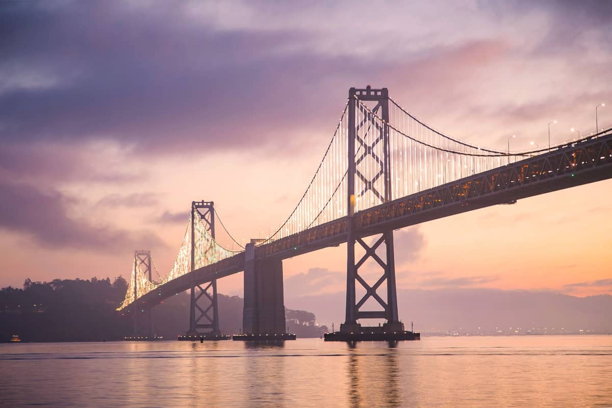
The Embarcadero waterfront, running south from the Ferry Building toward Oracle Park, gives you the closest unobstructed views of the Bay Bridge's western tower and suspension cables from the San Francisco side. On a clear morning, the silvery cables catch the light and the tower seems to float above the low bay haze. By midday, the light flattens. Late afternoon and early evening produce the most dramatic conditions: the western sun catches the bridge from behind you, and the Bay Bridge tower takes on a warm, slightly amber tone against the darkening east.
For photographers, the best fixed viewing spots along the Embarcadero are roughly between Pier 14 and Pier 7, where you can compose a frame with the bridge in the background and the bay's activity, including container ships, ferries, and sailboats, in the foreground. The pier railings also give you a stable surface for long exposures after dark, when the bridge's white LED lighting system illuminates the suspension cables in a long, clean arc across the bay.
💡 Local tip
San Francisco's fog is thickest in summer mornings, particularly June through August. If you want clear views of the Bay Bridge, September and October are consistently your best months. Arrive before 9am or after 4pm to avoid direct overhead glare on the water.
The Embarcadero itself is worth spending time on before or after viewing the bridge. The Ferry Building Marketplace sits at the foot of Market Street, roughly a 10-minute walk from the best bridge viewpoints, and makes a natural starting or ending point for a waterfront walk.
The Eastern Span Bike and Pedestrian Path
The one part of the Bay Bridge where you can actually walk and cycle is the eastern span, between Oakland and Yerba Buena Island. This dedicated path runs along the north side of the newer eastern structure. It does not continue across the western span into San Francisco, so it is not a way to cross the full bay on foot or by bike. Think of it as a bay-level experience of the bridge's engineering, with sweeping views back toward San Francisco, down into the water, and out toward the East Bay hills.
Access to the eastern span path is from the Oakland side, near the Bay Bridge toll plaza area. The path runs out over the bay to Yerba Buena Island and the Bimla Rhinehart Vista Point; hours and access conditions should be confirmed through the Metropolitan Transportation Commission or the Bay Trail organization before visiting, as closures for maintenance do occur.
⚠️ What to skip
There is no pedestrian or bike access from the San Francisco side of the bridge. Do not attempt to walk onto the western span roadway. It is illegal and extremely dangerous.
Driving Across: What to Expect
For many visitors, crossing the Bay Bridge is a practical necessity rather than a sightseeing choice, typically on the way to Oakland, Berkeley, or the East Bay. Westbound traffic, heading toward San Francisco, is tolled; eastbound is free. Tolls are collected electronically via FasTrak or with a pay-by-plate option, and cash is no longer accepted at the toll plaza. Current toll rates are set by the Bay Area Toll Authority and can be verified on the Bay Area FasTrak website, as rates adjust periodically.
From a car, the crossing itself takes about 10 to 15 minutes in light traffic. You pass through the Yerba Buena Island tunnel midway across. The views from the upper deck of the bridge are genuinely impressive on a clear day, particularly looking north toward Alcatraz and the Golden Gate from the suspension section, though you will only catch glimpses while driving.
If you are planning to visit Oakland or Berkeley as a day trip, the bridge is an unavoidable part of the journey. For broader context on getting around the region, the guide to getting around San Francisco covers BART, the F-line, ferries, and driving options in detail.
Night Lighting and Special Events
Artist Leo Villareal's Bay Lights installation on the western span's cables debuted in 2013 with 25,000 white LEDs, went dark in 2023 after weather and corrosion took a toll, and returned in March 2026 as a rebuilt system with tens of thousands of custom LEDs. Produced by the nonprofit Illuminate, the display runs nightly from dusk to dawn on the northern cable plane; confirm current operating status at illuminate.org before planning a special trip around it.
When the lights are running, a post-dinner walk along the Embarcadero with the illuminated cables in view is one of the more memorable free experiences in the city. Even with standard bridge lighting alone, the western span remains a strong nighttime subject from Pier 14 and nearby waterfront vantage points.
For context on the city's best vantage points overall, including rooftop bars and hilltop parks with bridge views, the best views in San Francisco guide covers options across multiple neighborhoods.
Practical Notes: Getting There and What to Bring
The easiest way to reach the best viewing spots is via the F-line historic streetcar along Market Street and the Embarcadero, or by walking south from the Ferry Building. BART's Embarcadero Station drops you at street level near the waterfront. The Embarcadero is flat and fully accessible by wheelchair or stroller along its wide, paved promenade.
Wear layers. The Embarcadero waterfront is exposed to bay wind, which picks up significantly in the afternoon and can make a 65°F day feel considerably colder. In summer, morning fog can reduce visibility significantly. Autumn visits, particularly September and October, offer the clearest skies and the least wind.
For photography, a moderate telephoto lens (70–200mm equivalent) lets you isolate the tower and cable geometry from the waterfront. For the Bay Lights after dark, bring a tripod or use a pier railing for stability. Wide-angle shots from near Pier 14 capture both the bridge and the foreground bay activity in a single frame.
If you are combining the Bay Bridge visit with a broader waterfront itinerary, Ferry Plaza Farmers Market runs on Tuesdays, Thursdays, and Saturdays and is located within easy walking distance of the best bridge viewpoints.
Insider Tips
- For the sharpest photographs of the Bay Lights, visit on a night with low or no wind. Rippled water creates distracting reflections; calm nights produce a cleaner, more mirror-like bay surface that doubles the visual impact of the LED installation.
- Pier 14 juts out slightly over the water and is publicly accessible at all hours, giving you a slightly closer, unobstructed angle on the bridge than the standard Embarcadero walkway.
- The view of the Bay Bridge from Treasure Island, an artificial island created north of Yerba Buena Island, is one of the most dramatic in the Bay Area. The entire San Francisco skyline appears behind the bridge's western span. You can reach Treasure Island by car via a connector road off I-80. Check current access conditions as redevelopment work on the island has affected access in the past.
- September and October are the warmest, clearest months in San Francisco due to the city's Mediterranean climate. Fog and overcast skies during June and July can obscure bridge views almost entirely before midday.
- The Bay Bridge appeared in several significant 20th-century photographs taken by Dorothea Lange and other documentary photographers. At opening in 1936, it was among the largest steel bridges in the world, making it a symbol of Depression-era American industrial ambition.
Who Is San Francisco–Oakland Bay Bridge For?
- Architecture and engineering enthusiasts who want to see one of the largest steel bridges in the Western Hemisphere up close
- Photographers, particularly those shooting at golden hour or after dark when the Bay Lights installation is active
- Cyclists willing to access the eastern span bike path from the Oakland side for a unique bay-level perspective
- Travelers on a budget looking for a free, high-quality visual experience along the Embarcadero waterfront
- First-time San Francisco visitors building a waterfront itinerary that combines the Ferry Building, the bay views, and the iconic bridge silhouette
Nearby Attractions
Other things to see while in The Embarcadero:
- Exploratorium
The Exploratorium is a hands-on museum of science, art, and human perception on San Francisco's Embarcadero waterfront. Founded in 1969, it houses hundreds of interactive exhibits across a refurbished pier building, making it one of the most engaging indoor experiences the city offers.
- Ferry Building Marketplace
The Ferry Building Marketplace occupies one of San Francisco's most storied waterfront landmarks, a restored 1898 Beaux-Arts terminal at the foot of Market Street. Free to enter, it houses around 50 food vendors, artisan producers, and restaurants, with a farmers market three days a week year-round drawing the city's top chefs and serious home cooks alike.
- Ferry Plaza Farmers Market
The Ferry Plaza Farmers Market, operating since 1993 outside San Francisco's landmark Ferry Building, is one of the most respected farmers markets in California. With free admission, a waterfront setting, and year-round operation three days a week, it draws serious food lovers and curious visitors alike.